

Utah map
Draper map
About 50,166 people live here (Census Bureau, 2024 estimate). The sheet's index lists 300 streets; Veterans Memorial Highway, Highland Drive and Minuteman Drive cross the most grid squares. Things to do inside the boundary: Loveland Living Planet Aquarium.
Open the map (PDF, US Letter)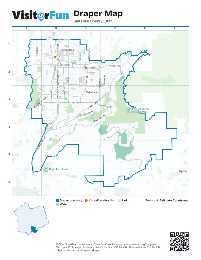
Street index of Draper
Each street on the sheet and the grid squares it crosses.
- Veterans Memorial HighwayB1, B2, B3, B4, A5, A6
- Bangerter HighwayA3, B3
- 12300 SouthA2, B2, C2
- 11400 SouthA1, B1, C1
- 700 EastC1, C2
- 1300 EastC2, C3
- State StreetB1, B2
- Draper ParkwayC2, D2
- 12600 SouthA2, B2, C2, D2
- Highland DriveD1, D2, C3, D3, B4, C4
- Minuteman DriveB2, B3, B4, A5, B5, A6
- Traverse Ridge RoadB4, C4, D4, D5
- Suncrest DriveD4, E4, D5, E5, E6
- 300 EastB1, B2, B3
- Lone Peak ParkwayB1, B2, B3
- 13800 SouthB3, C3
- 600 WestA3, B3, A4, B4
- Bangerter ParkwayB3, B4
- 13490 SouthA3, B3
- 200 WestB3
- 14600 SouthB4
- Waynes World DriveC3
- Jordan GatewayB1
- Pioneer RoadD1, E1, C2, D2
- Pony Express RoadB2, B3, B4
- 150 EastB1, B2, B3
- Fort StreetC2, C3
- Vista Station BoulevardA2, B2, A3, B3
- Mike Weir DriveD3, C4, D4
- Steep Mountain DriveB4, C4, B5
- 13200 SouthB3, C3, D3
- Deer Ridge DriveD4, C5
- 12200 SouthB2, C2, D2
- 700 WestA1, A2
- Kimballs LaneB1, C1
- Carlquist DriveB2, C2, C3
- 12650 SouthB2, C2
- Rambling RoadC3, D3
- Golden Pheasant DriveB2, C2
- Future WayB4
- 11950 SouthB1
- Frontrunner BoulevardA2, B2, A3, B3
- 1000 EastC1, C2
- Galena Park BoulevardA2, B3
- 12450 SouthB2, C2
- Stokes AvenueB3, C3
- 900 EastC2
- 12150 SouthB2, C2
- Charger WayC2
- 13775 SouthB3
- 450 EastC2
- 425 WestB3
- Ikea WayB3
- Vista WayB1
- 12230 SouthB2, C2
- 14015 SouthB3
- Hidden Valley DriveC2
- Vestry RoadC3, D3, B4, C4
- Willow Springs LaneB2, C2
- Lower Corner Canyon TrailD3
- Southfork DriveB3, C3, B4
- Eagle Crest DriveD4, E4, D5
- East Deer Ridge DriveC5, D5
- Aintree AvenueD3
- Manilla DriveB4
- Election RoadB1
- 13400 SouthB3, C3
- Rocky Mouth LaneC4
- 800 EastC1, C2
- 12000 SouthB1, C1
- Old English RoadC3
- Vahe StreetA2
- 12500 SouthC2, D2
- 12100 SouthB2, C2
- Springtime RoadD4, E4
- Thornberry DriveB1, C1
- Pheasant View DriveB2, C2
- Boulter StreetD2, D3
- Lone Rock DriveC2, C3
- Brookings DriveD5, E5
- Lone Peak LaneC3
- Scenic Pointe DriveB4
- Levengrove DriveD6
- Golden Harvest RoadB2
- Canyon Pointe RoadE4
- 600 EastC2, C3
- Sunset Stream WayC3
- Relation StreetD2
- Seven Oaks LaneD4
- Skaggs Catholic Center RoadB1
- Marion Vista DriveB4
- Draper Heights WayC4
- Cranberry Hill DriveB1, C1
- Longbranch DriveD4, D5
- Tuscalee WayD3
- Green Clover RoadB2, B3
- Timoney RoadD3
- Pond Ridge DriveC1, C2
- Ellerbeck LaneD2
- Maple Park CourtC4
- Somerset Ridge DriveD2
- Canyon Breeze LaneC3
- Walden LaneC2
- Midlake DriveB2, C2, C3
- Molasses Mill DriveC3, C4
- Life Science WayB2
- Engelmann DriveB1
- Rocky Knoll LaneC4
- Cherry Crest DriveB2, B3, C3
- Junegrass DriveA1, B1
- Hackamore DriveC3
- Nashi LaneC3, D3
- Stephens View WayA2
- Stone Canyon DriveC3, D3
- Brookside DriveD5
- Winged Trace CourtE5
- 1100 EastC2, C3
- Bear Mountain DriveD2
- Indian Wells LaneD2
- Data DriveB3
- Akagi LaneD3
- Inauguration RoadB1
- Long Tail DriveC2
- Bear Hills DriveE1, E2
- Osborne LaneC3
- Catania DriveD1, E1, D2
- 265 WestB2
- Tuscany Creek WayD1, D2
- LeAmbra LaneC4
- Olive Berry LaneB1
- Wayfield DriveB4
- Tumbleweed WayD3, D4
- Springdale WayD3
- Parowan WayB4, C4
- Sunset Dunes WayC4
- 13275 SouthB3
- Bellevue WayB3, C3
- Fielding Hill LaneD5
- 1840 EastD2
- Moose Hollow DriveD2
- Timber Ridge DriveC3
- Aiden Ridge DriveA1, A2
- Braidhill DriveB4, C4
- High Berry LaneB1, C1
- Bridgefield DriveB4
- Sage Hollow DriveD3
- 1700 EastD2
- Ranchero DriveC3
- Elk Glen DriveC4, D4
- Dearborn View DriveB4
- Carraway LaneC2
- Iron Horse PlaceD2
- Bubbling Brook LaneB1
- Bechers Brook WayD3
- Beachwood DriveC3
- Magic Wand StreetC3, D3
- Draper View RoadC4
- Lone Oak DriveD4
- Day Meadow DriveB2, B3
- Point DriveB3
- Newport Dawn DriveC2, C3
- Candy Pull DriveC3
- Rosefield LaneC3
- Laneys WayC4
- Corner Bridge LaneB3, C3
- Triton Quest WayB4
- Redberry RoadB2
- Cottage View LaneB1
- Ensign Point LaneB3
- Rockwell VistaC3, C4
- Winged Bluff LaneD4
- 13165 SouthB3
- Constitution AvenueC2
- Village Crest DriveD4
- 14000 SouthB3
- Camden Park LaneC1
- Sweet Berry DriveB1
- Annie Lace WayD3
- Montane DriveD2
- Summerharvest DriveC2
- Cindy LaneC2
- Webb RoadA2
- Snow Blossom WayD4
- Bridle Trail RoadC3
- Brambleberry LaneB1, C1
- Canyon End DriveE4
- Blue Heron DriveC1
- Beaumont WayC3
- Brayden WayB4, C4
- Vintage View LaneC4
- Bella Monte DriveB3
- 11900 SouthC1
- Bricker DriveB3
- Glacial Peak DriveD4
- Shortcut DriveE4
- Eagle Chase DriveD4
- Osborne Fox WayA1
- Cypress Point WayD2
- Ember DriveD4, E4
- Perspective WayB4
- Whisper Bend DriveC2
- Trail Crest CourtD4
- Pine Mesa DriveC3, D3
- Shadow View LaneC1
- Spyglass Hill DriveD3, D4
- Meadow Bluff LaneD4
- 65 EastB4
- Tilden Parc LaneC2
- 13240 SouthB3
- Alan Point DriveA1
- New River DriveD2
- Camden RoadC1
- Rolling Green DriveD3, D4
- Brown Farm LaneB3, C3
- Chandlerpoint WayB4
- Mountain Berry DriveB1, C1
- Cephus RoadA2
- Farm Hollow LaneB3, C3
- Sprague LaneB3
- Wylie LaneD3
- 1020 EastC2, C3
- Horton WayD6
- Daisyfield DriveB3, B4
- Arrow Creek DriveC3
- Fayview LaneC2
- Halls Creek RoadB1
- Haven Crest RoadB4, C4
- Skyler DriveC3
- Willow Wood DriveC1
- Mercer Hollow CoveE5
- Traverse Point DriveB4
- Twin Ridge DriveB1
- Park Presidio WayA3, B3
- 13130 SouthB2
- Pristine DriveC4
- Corner Wood DriveC3
- Draper Hill DriveB4
- Bluff Point DriveD4
- Hawberry RoadC3
- Stonebridge DriveB2
- Hickenlooper WayC3
- Gray Fox DriveD3
- Ridge Oak LaneA1
- 2000 EastD2
- Fox Crossing LaneC2
- Richins RoadD2
- Costanza WayD2
- Viscaya DriveD5, E5
- Shadowlands LaneD2, D3
- Dairy LaneB3, C3
- Hickory Ridge LaneD2
- Rolling Hills WayA1, B1
- Hollow Creek RoadC3
- Kodiak CourtD2
- Lantern LaneD4
- Tripp LaneC3
- 13065 SouthB2
- 13100 SouthB2
- Corner Ridge DriveC3
- Lakemont DriveC3
- Manfield WayC2
- Beverlee Ann DriveB1
- Normandy Loop LaneC1
- Genova DriveD1
- Business Park DriveB2
- Walnut Grove DriveD4, D5
- Bear Creek DriveD2
- Senior Band RoadC3
- Tall Woods DriveD4, D5
- Mountain Crest DriveD2
- Canyon Wild RoadE4
- Brewster DriveB4, C4
- Clover DriveC2
- Auburn Sky DriveE4
- Jarvie LaneC3
- 12900 SouthC2, D2
- Honeyfield DriveB4
- Crystal Spring DriveC2
- Woodridge Oak DriveC2, B3, C3
- New Saddle RoadC3
- Bear Hills CircleE1
- 12610 SouthC2
- Wasatch Point LaneB3
- Jonathan View LaneA2
- Old Saddle RoadC3
- Round Tree LaneD4
- Auburn Ridge LaneD4
- Mule Deer DriveD3
- Sunset Crest WayA1, B1
- Canyon Vine CoveD3, D4
- Cherry Creek LaneD2
- Fairmont Hill CourtB4, C4
- Burning Oak DriveD3
- Douglas Vista DriveA1
- Course View LaneD2
- Lone Hill DriveD4, E4
- Riparian DriveC1
- Somerlin DriveD2
- Crimson Oak DriveD3
- 13560 SouthB3
Things to do on the Draper map
Places on the map
- 7-Eleven
- Adagio Park
- Airborne Draper
- American Preparatory Academy
- Boondocks Fun Center
- Browns Pond
- Corner Canyon
- Corner Canyon Duck Pond
- Corner Canyon High School
- Corner Canyon Regional Park
- Deer Ridge Off-Leash Area
- Draper City Hall
- Draper Cycle Park
- Draper Elementary School
- Draper Park
- Draper Park Middle School
- Flight Park State Recreation Area
- Galena Hills Park
- Galena Soónkahni Preserve
- IKEA
- Jordan River Rotary Park
- Juan Diego Catholic High School
- Lone Peak Business Park
- Lone Peak Hospital
- Maack Hill
- Mehraban Wetlands Park
- Oak Hollow Elementary School
- Potato Hill
- Red Rock
- Skaggs Catholic Center
- Smith Fields Park
- South Mountain Golf Course
- South Mountain Park
- Steep Mountain Park
- Suncrest Park
- Suncrest Village Green Park
- United States Post Office
- Wheadon Farm Park
Next to Draper
- Alpine
© OpenStreetMap contributors, Open Database License, openstreetmap.org/copyright · Map data: Protomaps · Boundary: Who's On First (CC-BY 4.0); Quattroshapes (CC BY 2.0)















