

Utah map
Holladay map
About 30,588 people live here (Census Bureau, 2024 estimate). The sheet's index lists 300 streets; Holladay Boulevard, Belt Route and Highland Drive cross the most grid squares. Also on it: Old Mill Golf Course, Cottonwood Country Club and Creekside Place.
Open the map (PDF, US Letter)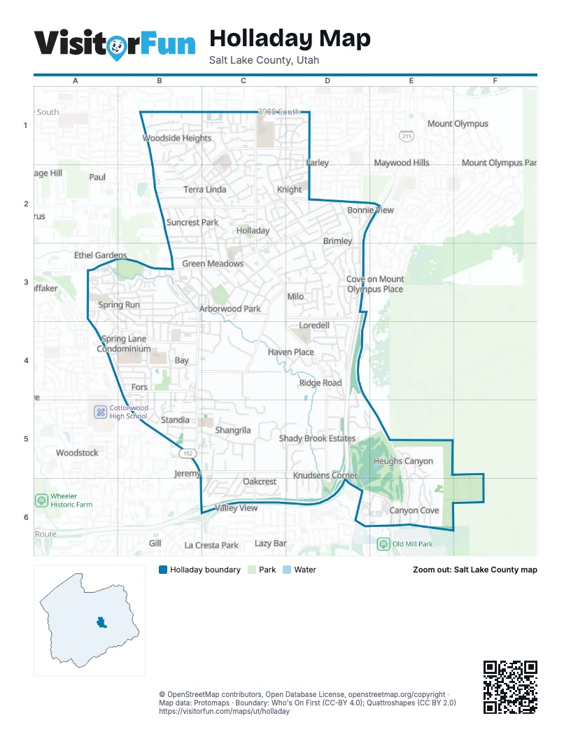
Street index of Holladay
Each street on the sheet and the grid squares it crosses.
- Belt RouteD2, E2, D3, D4, D5, C6, D6
- Highland DriveB1, B2, B3, B4, B5, B6, C6
- Van Winkle ExpresswayA4, B5
- 6200 SouthB5, C5, D5, D6, E6
- Holladay BoulevardB1, B2, C2, C3, D3, D4, D5, D6
- 2300 EastC1, C2, C3, C5, C6
- Murray Holladay RoadD2, A3, B3, C3
- 3900 SouthB1, C1, D1
- 4500 SouthB2, C2, E2
- Big Cottonwood RoadC5, D5
- 5600 SouthB4
- 4430 SouthC2, D2, E2
- 1300 EastA3
- 3000 EastD6
- 6100 SouthB5
- Wasatch BoulevardD3, D4, D5, E5, E6
- Lincoln LaneC1, D1, B2
- Cottonwood LaneC3, D3, C4, C5
- Spring LaneA3, A4, B4
- 2700 EastD1, D2
- Walker LaneB4, C4
- Casto LaneD3
- 6400 SouthB6
- Big Cottonwood Canyon RoadD6
- Laney AvenueC2, C3
- Wander LaneC2, D2, D3, D4
- Wallace LaneD2, D3
- Hillsden DriveD4
- Lakewood DriveA4, B4
- Arbor LaneB3, C3
- Kentucky AvenueD2, C3, D3
- Kings Row DriveA3, B3
- Naniloa DriveD3
- Meadowmoor RoadA3, B3
- Valley View AvenueC3, D3
- Canyon Cove DriveE5, E6
- Camille StreetC1, C2, D2
- Fieldcrest LaneA3, B3
- Tolcate LaneD5
- Viewmont StreetC3
- Memory LaneB3, C3
- Cresthill DriveB2, C2
- Woodcrest DriveB4
- Park PlaceB4, B5
- Heughs Canyon DriveE5, E6
- Fardown AvenueB5, C5
- Pheasant WayB4, C4, C5
- Morning Star DriveD1, D2
- Millrock DriveE6
- Brentwood DriveC5, D5
- 2000 EastC1
- Olympus DriveC1, D1
- Oakhill DriveC5
- Haven LaneC4, D4
- Cumberland RoadC1, C2
- Moor Mont DriveB3, B4
- Cottonwood Club DriveB4
- Sycamore DriveB2, C2, C3
- 4675 SouthB3, C3
- Lynne LaneC1, C2
- Moor Dale LaneB3
- Stratton DriveD2, E2, D3
- Westmoor RoadB3, B4
- Rodeo Walk DriveB3
- Gurene DriveB3, B4
- Southmoor DriveB4
- Terra Linda DriveB2, C2
- 2100 EastC3, C4, C5
- Highland CircleB3
- Holloway DriveB1, C1, B2, C2
- Spring Run DriveB3, B4
- Apple Blossom LaneD2
- Gundersen LaneB1, C1
- Deerwood LaneD5
- Field Rose DriveC5
- 4510 SouthD2
- Albright DriveB2, C2
- Arcadia LaneB2, C2
- Wayman LaneD4
- Sandpiper CircleA4
- Sycamore LaneB3, C3
- Melony DriveC2, D2
- Silver Hawk DriveD4, D5
- Holly LaneC2, C3
- Bonair StreetC3
- Russell StreetC2
- Whitewater DriveD5
- Wren RoadC3, D3
- Butternut RoadC2
- Hugo AvenueC2, C3
- Osage Orange AvenueB2
- Sandpiper DriveA3, A4
- South Woodside DriveB1
- 3990 SouthB1
- Oles LaneD5, D6
- Capricorn WayC1, D1
- Clearview StreetC2, C3
- 5340 SouthC4
- Rowland DriveD1, D2
- Juniper WayD4
- Severn DriveB1
- Delaware LaneB3
- Branch DriveD3
- Indian Rock RoadD4, D5
- Blue Spruce DriveD4
- Suada DriveC1
- Longview DriveB1, B2
- North Woodside DriveB1
- Howey DriveC6
- El Dorado DriveB1, C1
- Lincoln CircleC1
- Bron Breck StreetD3
- Wellington StreetB2
- Woodside DriveB1, C1
- Colony DriveA3, B3
- 3970 SouthB1, C1
- Panorama WayC2
- Winward DriveB4
- Delsa DriveD1
- Stanford LaneD3
- Mercury DriveC1
- Edgewood DriveA4, B4
- Wrenhaven LaneC6
- Crest Mount DriveE6
- Wardway DriveD1
- Wanda WayD2
- Regency StreetD3
- Oakdale DriveB4, B5
- Charleston LaneB5
- Morningside DriveD1
- Oak Canyon DriveE5
- Meadowcrest RoadC5, C6
- Spring Gate DriveA4, B4
- Morgan DriveD1
- Alvera DriveD4
- 5150 SouthB4
- Box Wood RoadC5, C6
- Canyon Crest DriveE6
- Shadow Wood CircleC3
- Chanin Vista DriveB3
- Milo WayD3
- Sahara DriveC2
- Haun AvenueC6
- Venus CircleC1, D1
- Bramble WayC2, D2
- Suncrest DriveB2
- Carriage LaneC2
- Lone Peak DriveB4
- Flamingo DriveD3
- Frontier RoadB5
- Keddington LaneC2, D2
- Panorama DriveC1, C2
- Hidden Creek CourtA3
- Oak Park LaneD4
- Aspen Hollow LaneD2
- Evening Star DriveC1, D1
- Peach StreetD2
- Pheasant LaneC5
- Yorktown DriveA3
- Marilyn DriveC3
- 2075 EastC5
- Northwood RoadD4
- Maurice DriveD2
- 5290 SouthB4, C4
- Gun Club RoadE6
- Sommet DriveD3
- Beaumont DriveB5
- Donelson LaneB4, C4
- Boyes StreetC3
- Cobblecrest RoadC6
- Melodie Ann WayC2
- Rainbow Point DriveC1
- Applewood AvenueC5
- Cobblerock LaneC5, D6
- Edgemoor DriveC3
- Solar DriveC1, D1
- Baywood DriveB4
- Oliver DriveC1
- Minden DriveB5
- Pheasant CircleB4, C4, C5
- Tolcate Hills DriveD5, E5
- Tolcate Woods LaneD5
- 3170 EastE6
- Laurelwood StreetB4, B5
- Wagstaff DriveB2
- Verona CircleD4
- Waimea WayD3
- Canyon Ranch RoadE6
- 2710 EastD5, D6
- Innsbruck WayB5
- Eastmoor RoadB4
- Shangri LaneC5
- Fairbrook LaneC3
- Sandpiper WayA4
- Cherry Blossom LaneD2
- London Plane RoadB2
- Olympus Grove LaneB1, B2
- Walker Woods LaneC4
- Marwood DriveC1
- 1645 EastB3
- Fairoaks DriveB4
- Boabab DriveA3, B3, B4
- County RoadD4, D5
- Ichabod StreetD3
- Deerwood Creek CircleD5
- Cecil DriveD1
- Senoma DriveC6
- Hidden Meadows DriveB3
- Bunkerhill RoadB3
- Linden StreetC5
- Loredell DriveD4
- Olympus Point DriveB4, C4
- 5960 SouthD5
- 6425 SouthB6, C6
- Spring Creek RoadD2
- Wildwood DriveB5, C5
- Damon WayB3
- Van Cott RoadD5, D6
- Heughs Canyon WayE5
- Oakcrest LaneC6
- Cecelia CircleB5
- Leo WayD2
- Providence CourtD5
- Fairview DriveC3
- Clover LaneC1
- Crest Mount CircleE6
- Kayland WayC2
- South Deerwood Farms LaneD5
- Doris WayC2
- Foxmont LaneA3
- Hedgewood CourtB5, C5
- Wailua WayD3
- Villa Park LaneB5
- Shady Brook LaneD5
- Ichabod PlaceD3
- Merlyn DriveB4
- 2230 EastC5
- 6380 SouthC6
- 4505 SouthD2
- Briarcreek DriveC2
- Glenna DriveD2
- Holladay View PlaceB2
- Rebecca CircleA3
- Woodbridge DriveB3
- Locust LaneC2, C3
- Ribbon LaneC2
- Woodline DriveB1
- Old Orchard LaneD5
- 3075 EastD3
- 4000 SouthC1
- Sands DriveC2
- Nila WayD1
- 2870 EastD3, D4
- Beverly Park RowB3, C3
- Canyon Winds LaneE5
- Summerspring LaneC1
- 4215 SouthD1
- La Tour StreetC5
- Milky WayC1
- Valene StreetD3
- Lockhart RoadD3
- Willow RoadB2
- Swasont WayD3
- Floribunda DriveD3
- Laurikay DriveC2
- Wisteria View LaneD5, D6
- Phylden DriveC2
- Calann DriveB4, B5
- Canyon Cove PlaceE6
- Jennie LaneD2, D3
- Grover LaneB2
- 1950 EastB1
- 4650 SouthB2
- Taroona DriveB3, B4
- Waldo DriveB2, C2
- 2110 EastC4
- 6320 SouthC6
- Nunley CircleB5
- Saddleback DriveB4
- 2770 EastD2
- Feramorz DriveC1
- 2175 EastC1
- Woodmont StreetB3, B4
- Merribee WayB5
- Verness CoveC5
- Diamond Hills LaneB5, C5
- Highland Park CourtB4, B5
- Karren StreetC1, C2
- Chapel DriveD2, D3
- Delann LaneB5
- Lincoln Pines CourtC2
- Madsen View CourtD5
- 4135 SouthD1
- Delmont DriveC3
- Highland Down LaneB4, C4
- Tanglewood DriveB2
- 2050 EastC4
- 1580 EastB4
- 6420 SouthD6, E6
- Briarwood DriveC2
Places on the map
- 7-Eleven
- Black Dimond Village
- Block Party 2700
- Bonneville Junior High School
- Brown Floral
- Cafe Madrid
- Canyon View Credit Union
- Carmel of the Immaculate Heart of Mary Convent
- Challenger School - Holladay
- Chase
- Cooper Tires
- Cottonwood Country Club
- Cottonwood Elementary
- Creekside Park
- Creekside Place
- Crestview Elementary School
- Cruzrs
- FedEx
- Hampton Inn Salt Lake City Cottonwood
- Harmons
- Holladay Center
- Holladay City Hall
- Holladay City Skatepark
- Holladay Library
- Holladay Memorial Park
- Holladay Park
- Holladay Park-N-Ride
- Holladay Post Office
- Howard R Driggs Elementary
- Hyatt Place Salt Lake City/Cottonwood
- Knudsen Park
- Les Schwab Tire Center
- Leslie's Pastries
- McDonald's
- Oakmont Plaza
- Old Mill Golf Course
- Olympus High School
- Olympus Junior High School
- Spring Lane Elementary School
Next to Holladay
- Belle Meadows
- Bellwood Acres
- Blue Grass Acres
- Bonnie Brae
- Country Garden Estates
- Cove on Mount Olympus Place
- Crus
- Donjean
- Driftwood Estates
- East Meadows
- Ellison Woods
- Ethel Gardens
- Farley
- Fuller Gardens
- Gill
- Greenfield Village
- Haven Grove
- Highland Drive Park
- Holman
- Huffaker
- Hyland Lake
- Jamestown
- Jeremy
- Juniper
- Kimberly Park
- La Cresta Park
- Lazy Bar
- Majestic Heights
- Manor Estates
- Mar Vian
- Maywood Hills
- Mount Olympus
- Mount Olympus Acres
- Mount Olympus Hills
- Mount Olympus Park
- Nalani
- Oakcliff Park
- Oakcliff Park Two
- Olympus Cove
- Olympus View
- Paul
- Sage Hill
- Shady Grove
- South Morningside Heights
- Stev Linda
- Three Fountains East Condominium
- Valley View
- Woodstock
© OpenStreetMap contributors, Open Database License, openstreetmap.org/copyright · Map data: Protomaps · Boundary: Who's On First (CC-BY 4.0); Quattroshapes (CC BY 2.0)















