

Utah map
Midvale map
About 36,219 people live here (Census Bureau, 2024 estimate). The sheet's index lists 300 streets; Bingham Junction Boulevard, Veterans Memorial Highway and 7200 South cross the most grid squares. Also on it: Hillcrest High School, Midvale Yard and Topgolf.
Open the map (PDF, US Letter)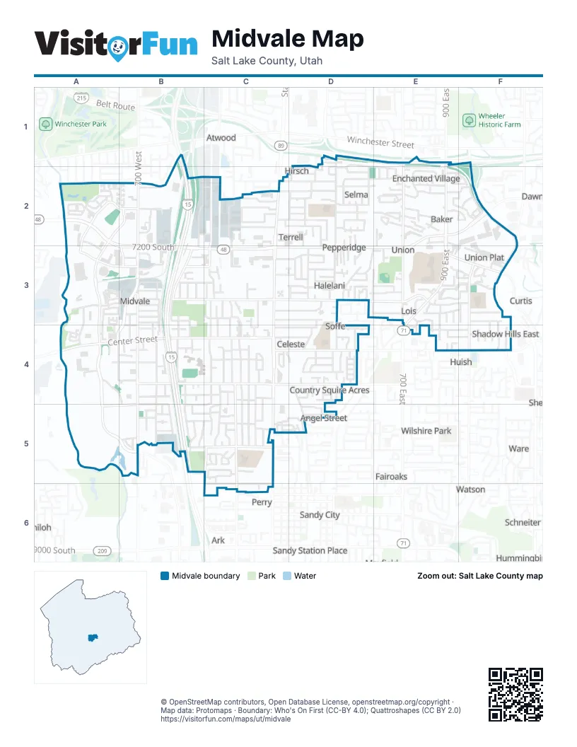
Street index of Midvale
Each street on the sheet and the grid squares it crosses.
- Veterans Memorial HighwayB1, B2, B3, B4, B5
- Belt RouteD1, E1
- State StreetC2, C3, C4, C5
- 7200 SouthA2, B2, A3, B3, C3
- Fort Union BoulevardE2, F2, C3, D3, E3
- Center StreetA4, B4, C4
- 900 EastE2, E3, E4
- 7800 SouthA4, C4, D4, E4, F4
- Union Park AvenueF1, F2, F3
- Jordan River BoulevardA2
- 750 EastE3, E4
- 7000 SouthA2
- Bingham Junction BoulevardA2, B2, A3, A4, A5, B5
- 700 WestB2, B3
- Holden StreetB3, A4, B4
- 1300 EastF2
- Main StreetB3, B4, B5
- 700 EastE1, E2, E3
- Wasatch StreetA4, B4, C4
- Cottonwood StreetC2, C3
- Monroe StreetC4, C5, C6
- Greenwood AvenueC3, D3, E3
- 6th AvenueB3, C3
- Ivy DriveA5, B5
- 8000 SouthC4, D4
- Princeton DriveB5, C5
- 1000 EastF3, F4
- Catalpa StreetB3
- River Gate DriveA2, B2
- South Union AvenueE3, F3
- Harrison StreetC5
- Coliseum WayA3, B3
- FL Smidth DriveA2, A3
- Hillcrest High DriveE3
- 7500 SouthC3
- Millennium StreetB3, C3
- Grandeur View WayB3
- Junction View DriveA3
- 1020 EastF3
- High Point ParkwayF4
- 7220 SouthF3
- 300 EastD1, D2, D3, D4
- Allen StreetB3, B4, B5
- Roosevelt StreetC4, C5
- Coolidge StreetC4, C5
- Grant StreetC3, C4
- Inglenook DriveC2
- Marquette DriveB5, C5
- North Union AvenueE2, F3
- 400 WestB2, B3
- Wilson StreetC4, C5
- 8600 SouthC6
- Canyon Ridge WayE3, F3
- Enchanted DriveE2
- Pioneer StreetC4
- Jackson StreetC4, C5
- Wood StreetC4, C5
- Adams StreetB4, B5
- 6850 SouthD2
- 6790 SouthC2, D2
- Acoma RoadD1, D2, E2
- Well Spring RoadE2, F2
- Oak StreetB4
- High Tech DriveC2, C3
- Cornell DriveB4, C4
- Rio Grande StreetB3, B4
- Ramanee DriveD3
- Garden View DriveC4
- La Salle DriveB5, C5
- Carlson AvenueC2, D2
- Nicoletti DriveC3, D3
- Alta View DriveB4, C4
- 7615 SouthC3, D3
- 7065 SouthC2
- Well Wood RoadE2, F2
- 150 EastD2, D3, D5
- Ridge Hill LaneE3, F3
- Lennox StreetA4, B4
- San Savino WayA3, A4
- Halelani DriveD3
- Union Creek WayF3
- 7660 SouthC4, D4
- Fairmeadows DriveE2
- Villager LaneD2, E2
- Resaca DriveC5, D5
- Casa Negra AvenueE3, F3
- Forbush AvenueC3, D3
- Tennyson AvenueD4
- Hoover StreetB5
- Casa Roja StreetE4, F4
- 2nd AvenueB3
- Cobblestone LaneE2
- Euro DriveA3, A4
- Millerberg DriveD4
- Locust StreetB3, B4
- 500 EastD1, D2
- Van Buren StreetC4, C5
- Jefferson StreetC3, C4
- Lincoln StreetC3, C4
- Columbia DriveC4
- Plum Tree LaneC2
- 6740 SouthD2, E2, F2
- Durham StreetC5, D5
- Summit Peak DriveA3, A4
- Larchwood DriveD2, E2
- 100 EastD2, D4, D5
- Tuscany View RoadA3, B3
- Perrine DriveD2
- 7720 SouthC4, D4
- Angel StreetD4, D5
- California DriveB3, C3
- Casa Verde StreetE3, E4
- Maple StreetC3, C4
- Seghini DriveA4, B4, B5
- 7670 SouthD4
- 7060 SouthC2, D2
- 180 WestC3
- 230 EastD2, D3, D5
- Casa Blanco AvenueE3, F3
- Fox Bridge DriveC5
- Bourdeaux DriveE2
- Connie DriveD3, E3
- Park StreetC3
- Commerce Park DriveB2
- 1st AvenueB4
- Olympus StreetC4
- Rena AvenueD2
- 7625 SouthF3
- 6815 SouthD2
- Fern DriveB4
- Chapel StreetB3, B4
- Mecham LaneF3
- Balboa DriveD3
- Normandy WayE2
- 6990 SouthD2
- Washington StreetB4, C4, B5, C5
- Presidio DriveA2, B2
- Lyndy DriveE3, E4
- Ropekey DriveA3, A4
- 160 EastD2
- 6715 SouthD2
- 7725 SouthA4, E4, F4
- 7570 SouthD3, E3
- 9th AvenueB3
- 1130 EastF3, F4
- Harvel DriveD4
- 6960 SouthB2
- Cobblestone DriveE2
- 7700 SouthF4
- Pepperidge DriveD2
- Grenoble DriveE2
- Park Reserve WayA2
- Downing StreetE2
- Chapel Hill DriveF3
- Brady LaneD4
- 7010 SouthE2
- 7100 SouthC2, D2
- Birch StreetC3, C4
- 525 EastD3
- Hayes StreetB5
- Stagg StreetB3, B4
- Chloe WayC5
- Carol WayD3
- Land Rush DriveE2
- Carmel DriveD3, E3
- 345 EastD2
- Chadds Ford LaneE3
- 600 WestB2
- Francesco WayA3, B3
- Chad Heights LaneD4
- Gardenia DriveB5
- Celeste DriveC4, D4
- Essex Court WayE2, F2
- Layne DriveD3
- 6910 SouthE2
- Village River LaneA2
- Sandra WayD4
- Free Land AvenueE2
- Village Bend LaneA2
- Pioneer AvenueC5
- 6770 SouthD2
- Ivy Woods LaneD3
- 7th AvenueB3
- Farm Wood LaneD4
- Spring Crest CourtE3, F3
- 145 EastD3
- 1200 EastF4
- 6825 SouthB2
- Legacy Center WayA2, A3
- Shelby View DriveE3
- Farm House LaneD4
- Creek Hill LaneE3, F3
- 90 EastD2, D3
- Amanda Lynn LaneC5
- Cypress StreetC3
- 415 EastD4
- Center SquareC3, C4
- Gables StreetE2
- 280 EastD4
- 8135 SouthD5
- 825 EastE2
- 8th AvenueB3
- 3rd AvenueB3
- Pamela WayC5
- 5th AvenueB3
- River Reserve CourtA2
- 6856 SouthE2
- 6890 SouthD2
- 4th AvenueB3
- Cox LaneC3, D3
- River Fox WayA2
- Kittridge DriveD2
- Lance StreetB5
- Rusty DriveD3
- Water Mill WayD4
- Taft StreetC4
- Casa Negra CircleF3
- Binary WayA4
- 260 EastD2
- 540 EastE2, E3
- 7390 SouthD3
- 6865 SouthD2
- South Crest CircleE3
- Mars WayC5
- Apple Honey LaneD3
- Heather StreetB5
- Rooftop DriveA4
- 7460 SouthD3
- Founder Point LaneA4
- Green Haven DriveD3
- Launa CircleD3, E3
- Spring Station WayC4
- Gables LaneE2
- Settlement CircleC5
- 520 EastD3
- Whimpy WayB3
- Casa Blanca DriveE3
- Elm StreetB3
- Pine StreetC3
- 190 EastD2
- Spruce StreetB3
- Blue Magic LaneB5
- Calbourne LaneC5, D5
- Tiffany Town DriveB5
- 6870 SouthE2
- Viansa CourtD3
- 270 EastD3, D5
- Floret LaneF2
- Woods Hollow CourtA4, B4
- Mill Grove LaneD4
- Angie CircleE2
- Ashbrook CircleD2
- Marla WayD3
- 420 EastD2, D3, D4
- 6980 SouthD2
- Whitecrest WayD3
- 6940 SouthD2
- 800 EastE2
- 7350 SouthD3
- Blisswood DriveC3
- Essex Court CircleF2
- 580 EastE3
- Station Landing WayD4
- 430 EastD2
- Smelter StreetB4
- Wolfe Grove CircleB5
- 775 EastE2
- Siena Vista LaneA3
- Launa StreetD3
- Sienna Park LaneF2
- Vaughn LaneD1, D2
- 210 EastD4
- Baker DriveE2
- Harrison CircleC5
- Jordan Walk WayA2
- Madison Meadow LaneE2
- Village Commons WayE2
- Cannara WayA3
- Station StreetD4
- 410 EastD3
- 6795 SouthE2, F2
- Inglenook CoveC2
- 7420 SouthC3, D3
- Blue Vista LaneB3
- Vantana CourtD1
- Greenwood CircleD3
- Suzanne DriveA2
- 95 EastD3
- Pearl CircleD3
- Chad StreetE3, E4
- Park Trail WayA2
- Wison Woods LaneD3
- 455 EastD2, D4
- 200 EastD2
- Iris Lumi LaneB5
- 855 EastE2
- Candlestick LaneC4, D4
- Howe CoveA3
- Marie DriveD3
- Union Village LaneD3
Places on the map
- Arby's
- Arctic Circle
- Astro Burgers
- Beehive Storage
- Big Mountain Barbell
- Bingham Junction
- Bingham Junction Park
- Boys & Girls Club
- Buffalo Wild Wings
- Burger King
- Casa Blanca
- Chick-fil-A
- Connie Crosby Family Resource Center
- Copperview Elementary
- Copperview Recreation Center
- Copperview Recreation Center Park
- Cornerstone Evangelical Free Church
- Culver's
- Cyprus Credit Union
- Denny's
- East Midvale School
- Econo Lodge
- El Potrero Market
- Extra Space Storage
- Fairfield Inn Midvale
- Garden East
- Goff Mortuary
- Golden Corral
- Greenwood Health Center
- Hillcrest High School
- Mail Center
- Midvale City Park
- Midvale Yard
- Midvalley School
- Park 'n' Ride
- Topgolf
- Union Park
- Union Point
- Zions Technology Center
Next to Midvale
- Alegre Vista
- Angel Street
- Ark
- Atwood
- Blue Grass Acres
- Brentmar Circle
- Capistrano Villa
- Cedar Terrace
- Chufar Acres
- Country Estates
- Curtis
- Driftwood Estates
- Endot
- Fairoaks
- Greenwood Meadows
- Harvard Park
- Huish
- Hummingbird
- Johnsonway
- Jordan Village
- Kenwood Villa
- Knollwood
- Landon Village
- Midvalley Manors
- Mingo Park
- Perry
- Ponderosa Park
- Sandy City
- Sandy Station Place
- Sandy Village
- Schneiter
- Shiloh
- Sunburst Meadows
- Ware
- Watson
- Wilshire Park
© OpenStreetMap contributors, Open Database License, openstreetmap.org/copyright · Map data: Protomaps · Boundary: Who's On First (CC-BY 4.0); Quattroshapes (CC BY 2.0)















