

Utah map
North Salt Lake map
About 23,593 people live here (Census Bureau, 2024 estimate). The sheet's index lists 300 streets; Veterans Memorial Highway, Highway 89 and Eagleridge Drive cross the most grid squares. Also on it: Eaglewood Golf Course, Albertsons and Pony Express RV Resort.
Open the map (PDF, US Letter)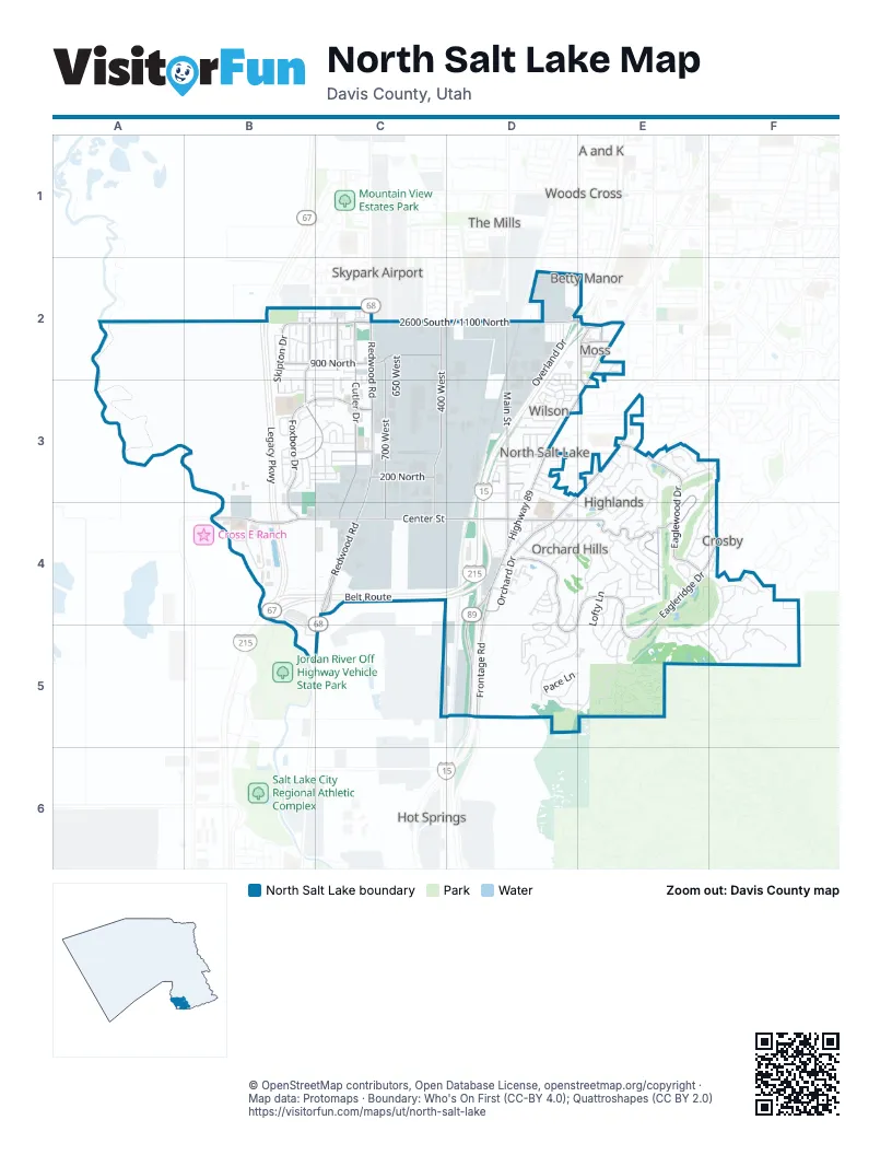
Street index of North Salt Lake
Each street on the sheet and the grid squares it crosses.
- Veterans Memorial HighwayD2, E2, D3, D4, D5
- Legacy ParkwayB2, B3, B4
- Belt RouteB4, C4, D4
- Highway 89E2, D3, E3, D4, D5
- Main StreetD2, E2, D3, D4
- 2600 SouthD2, E2
- Redwood RoadC2, C3, C4, C5
- Center StreetB4, C4, D4, E4
- Eagleridge DriveD4, E4, F4, D5, E5
- Orchard DriveE3, D4
- Eaglewood DriveE3, E4
- 2600 South / 1100 NorthC2, D2
- 1100 NorthB2, C2, D2
- Overland RoadD2, E2
- Cutler DriveC2, C3, C4
- Foxboro DriveB3, C3, B4
- 400 WestC2, C3, C4
- 900 NorthB2, C2, E2
- Fox Hollow DriveB2, B3, C3
- 700 WestC2, C3, C4
- Lacey WayE4
- 200 NorthC3, D3
- Foxhill RoadE3, E4
- Skipton DriveB2, B3
- Gary WayE4
- 3800 SouthD3
- 400 EastE2, E3
- 800 WestE2, E3
- Amberly DriveC2
- Cambridge DriveC3
- 350 NorthD3
- 1000 NorthE2
- 1100 WestD2
- 500 EastE2
- Nancy WayE4
- Fairway DriveE3, F3, E4, F4
- Frontage RoadD3, D4, D5
- Eaglewood LoopE4, F4, E5, F5
- Parkway DriveD5, E5
- Valley View DriveE3, D4, E4
- Eaglepointe DriveD5, E5
- Tanglewood LoopF4, F5
- Cynthia WayD4, E4
- Recreation WayB4, B5, C5
- Lofty LaneE4, E5
- Overland DriveD2, D3
- Pace LaneD5, E5
- Elk Hollow RoadF4
- Miller AvenueD5
- Stonehaven DriveB2, C2
- Wood Oaks LoopF5
- 300 NorthD3, E3
- Ridge Top LaneE4, E5
- Springwood DriveE3
- York DriveB2, C2
- Norfolk DriveB2, C2
- Eagle WayE4
- Excalibur StreetD3, E3
- Parkview DriveD4
- 1200 WestB4
- Raygene WayE4
- 650 WestC2, C3
- 100 NorthC3, D4, E4
- Wood Hill LaneE3
- 300 EastD4
- River Bend WayB4
- Eugene StreetE4
- Kingdon LaneD4
- 3500 SouthE3
- Scenic Hills DriveE3
- David WayE4
- Bella Vida DriveD4, D5
- Centennial DriveE4
- Odell LaneD3, D4
- Alton DriveC3
- Vista View LaneE5
- Edgewood DriveD4, D5
- Sugar Plum LaneE5
- Winter LaneD5
- Woodbriar WayE5, F5
- Pellinore StreetD3
- Cambria DriveB2
- Buckingham DriveB3
- 500 NorthC3, D3
- Cloverdale DriveD3
- Dorthea WayE4
- Franklin ParkwayD3
- Caleb DriveB3
- Birmingham LaneB3
- Constitution WayE4
- Walton DriveB3
- Union AvenueD2
- Rockwood DriveF5
- Wilson RoadD3
- Cobblecreek RoadD3
- Oakwood DriveE4
- Ironwood DriveF4
- Merlin StreetD3
- Guenevere StreetD3
- 750 WestC4
- Ridge Top CircleE4
- Duffer LaneE4, F4
- Jordan River DriveB4
- Eagle PassD5
- Sider DriveE3
- Stamford DriveC3
- City's Edge DriveD4
- Eaglegate DriveD4
- Southampton DriveC3
- Canyon View CircleD4, D5
- Bexley DriveB2
- Manchester DriveB3, C3
- Springhill DriveD4
- Robinson DriveC3
- Boston DriveB3
- Springridge DriveE3
- Mason LaneD4
- Percival StreetD2, D3
- Silvertree LaneD5
- Oldham DriveB3, C3
- Sunset Ridge DriveD4
- Acorn DriveE3, E4
- Galahad StreetD3
- Lakeside DriveD4
- Oak DriveE3
- 640 WestC3, C4
- Windsong LaneE4
- Coventry LaneE4
- Durham DriveC2, C3
- Independence WayE4
- Haworth DriveB3
- Hidden LaneE4
- Oakleaf LaneE3
- 175 SouthD4
- Hillside LaneD3
- Lancelot DriveD3
- 725 EastE3
- Wilton DriveB2, B3, C3
- 475 NorthD3
- 50 NorthE4
- Chatham DriveB3, C3
- Farnham DriveB3, C3
- Marialana WayE4
- Mont Clair DriveE5
- King Arthur WayD3
- Windsor DriveB3
- Oxford DriveC3
- Edgemont DriveD5
- 550 EastE3
- 600 NorthC3
- Angela WayE4
- Edgecrest LaneD5
- Pacific AvenueD3
- Ridgeline WayD4
- Rosewood LaneF4
- Madsen LaneE2
- Berkshire DriveB2
- Parkway CircleD5
- Grant LaneD5
- Somersby DriveB3, C3
- Club House CourtF4
- Maple DriveD3
- Elizabeth DriveC2
- North Pointe CircleC4
- 150 NorthD3
- 725 WestE3
- Oak View CourtE4
- Taylor WayD3
- 500 WestC3, C4
- Longleaf DriveB3, C3
- Stonehenge DriveB3, C3
- 125 EastD3
- 75 EastD3
- 175 EastD3
- Cove Crest CourtF4
- Eastpointe DriveE2
- Edinburgh DriveC2
- Carriage LaneD2
- 3400 SouthE3
- Colonial DriveD2
- North Towne LaneD3
- Chidester DriveB2
- Danby DriveC2
- Surrey LaneD2
- 950 NorthE2
- Woodcrest LaneF4, F5
- Allington DriveB2, C2
- Castleton DriveB2, C2
- Woodstock DriveC3
- Kent LaneB3
- Vista WayD4
- Bamberger RoadD3
- Scenic Hills CircleE3, E4
- Oakleaf DriveE3
- Plum Tree CourtE5
- 675 EastE3
- Liberty RoadE4
- Walker LaneD4
- Abbotsford DriveB2
- Talon WayE4
- Adelburg DriveC2
- Kettering DriveC2
- Emily LaneD3
- 550 WestC2, E3
- Berkeley DriveC2
- Rothbury CourtC2
- Halstead DriveC2
- 250 NorthD3
- Cayias DriveE3
- Finley CircleD5
- Hillingdon CourtB2
- Hidden CircleE4, E5
- Lyndhurst DriveC3
- Sagramore StreetD3
- Bradford DriveB2, B3
- Greenwich DriveC3
- Winchester DriveC3
- 130 EastD4
- 60 NorthC4
- Fairway PlaceE3, F3
- Bunker Hill RoadE4
- Lillywood LaneE3
- Aerie CircleE4
- Ascot DriveB3
- Hexham DriveC2
- Old Station WayD3
- Newham CourtC2
- Sky Lark LaneE5
- Sir Kay WayD3
- Redbridge DriveC2
- Abbey DriveC2
- Canyon LaneD4, E4
- Somerset DriveC3
- 675 WestC2
- Country CourtE5
- Darcy DriveC2
- Mont Clair CourtE5
- 1250 WestD2
- Bellingham CourtB2
- 330 NorthD3
- Wellington AvenueC2
- Regency WayE3
- Sky Crest LaneE5
- Sutton DriveC2
- Skyview CircleE5
- Ellen LaneD3
- Kirsten LaneD3
- Pickering DriveC2
- Clifton DriveC2
- Valley View CircleE3
- 50 WestD3
- Gawaine StreetD2, D3
- 1000 WestD2
- Hillcrest WayD4
- 50 SouthD4
- Birdie CircleE4
- 3300 SouthE3
- Tristram StreetD2, D3
- Brigham LaneD3
- Compass CircleE2
- Dinivan StreetD2, D3
- Ivywell LaneC2
- Cordova CourtE5
- 850 NorthE2
- 775 WestE3
- 4000 SouthD3
- Tidwell DriveD3
- Picadilly CourtC2
- 175 NorthD3, E3
- Bristol StreetC2
- Wilstead DriveC2
- Lionel StreetD2, D3
- Chatteris DriveC2
- 210 NorthD3
- Sycamore AvenueE3
- Callie CourtC2
- Canterbury LaneB3
- Kensington DriveB3
- Tanglewood CourtF5
- Chelsea LaneB3
- Hillside Oak CircleE4
- 575 EastE3
- Geddy LaneE3
- 700 EastE3
- Surrey DriveB2
- Freedom DriveE4
- Leeds CourtB3
- Point DriveD4
- Benson LaneD3
- Bogey CircleF3
- Eagles Nest CircleE4
- Burkhill LaneD5
- Elk Hollow CircleF4
- Freedom CircleE4
- Lancelot CircleD3
- Sugar Plum CourtE5
- 3600 SouthD3
- Downfield LaneC2
- Meridian LaneC2
- Vantage DriveD4
Places on the map
- Access RV
- Albertsons
- Apollo Burger
- Atlantis Burger
- AutoZone
- Best Western Plus CottonTree Inn
- Bountiful Regional Center
- Camelot Community Pool
- Chevron
- Cyprus Credit Union
- Deer Hollow Park
- Eaglewood Golf Course
- Eaglewood Village Fishing Pond
- Flying J Travel Center
- Foxboro Elementary School
- Foxboro Hollow Park
- Golden West Credit Union
- Griffin's Golden Glow Auto Detailing
- Holiday Oil
- Hughes General Contractors
- Jerry Seiner Buick GMC
- Jiffy Lube
- Just Wash It
- KeyBank
- Lee's Marketplace
- Legacy Park
- Legacy Preparatory Academy
- Marathon
- Master Autotech
- Mathis Park
- Maverik
- North Salt Lake Post Office
- Orchard Elementary School
- Pony Express RV Resort
- Quick Quack Car Wash
- R&R BBQ
- Sandbar
- Sinclair
- South Davis Metro Fire Station #82
- Tunnel Springs Park
Next to North Salt Lake
- A and K
- Betty Manor
- Cahoon Acres
- Crosby
- Golden Meadows
- Hot Springs
- J Hill Johnson
- Manna Acres
- Meadow Crossing
- Miraleste
- Nelhoca Place
- Pedersen
- Sconberg
- Skypark Airport
- Spring Meadow
- Sundown
- The Mills
- Westwood
- Woods Cross
© OpenStreetMap contributors, Open Database License, openstreetmap.org/copyright · Map data: Protomaps · Boundary: Who's On First (CC-BY 4.0); Quattroshapes (CC BY 2.0)















