

Utah map
Ogden map
About 88,656 people live here (Census Bureau, 2024 estimate). The sheet's index lists 300 streets; Harrison Boulevard, Van Buren Avenue and Monroe Boulevard cross the most grid squares. Also on it: 21st Street Pond, Aultorest Memorial Park and Ben Lomond High School.
Open the map (PDF, US Letter)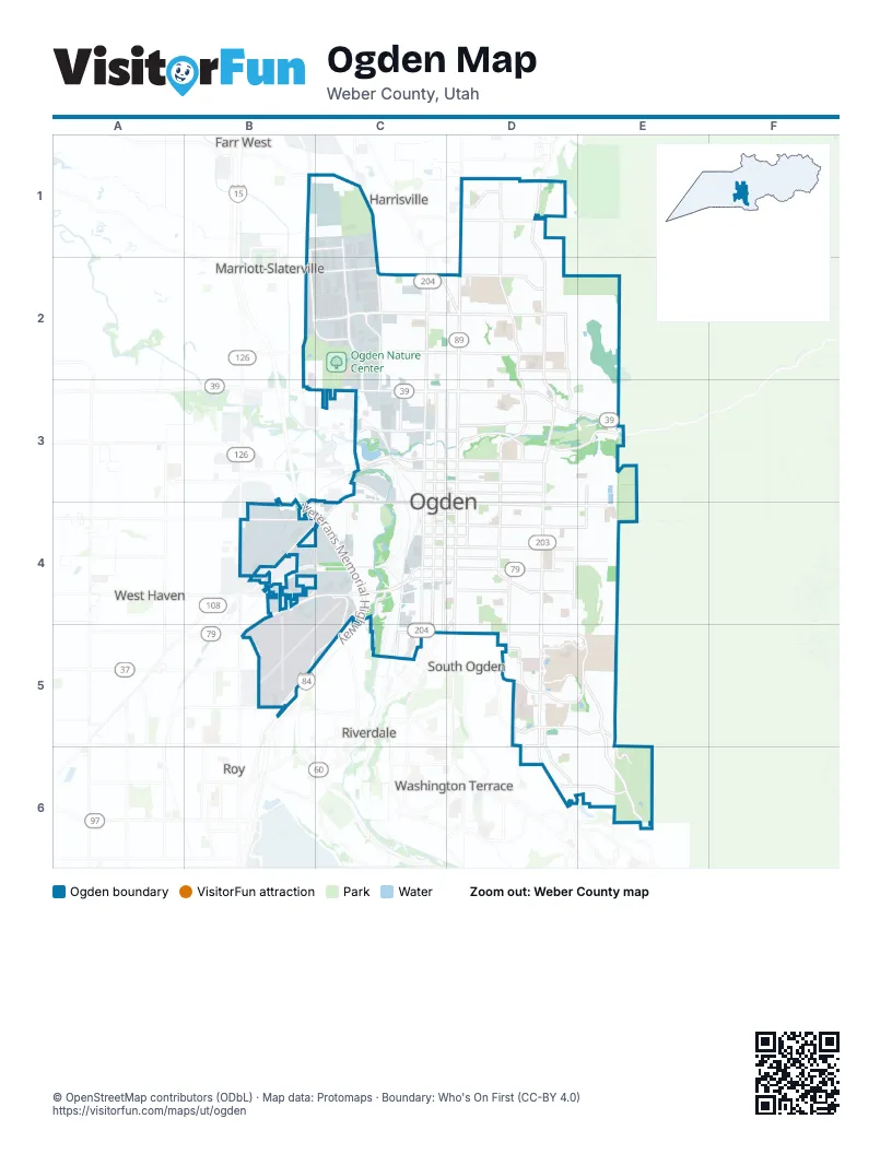
Street index of Ogden
Each street on the sheet and the grid squares it crosses.
- Veterans Memorial HighwayC4, C5
- Harrison BoulevardD1, D2, D3, D4, D5, D6
- Washington BoulevardD2, D3, D4, D5
- 12th StreetC3, D3, E3
- 31st StreetC4, D4
- 30th StreetC4, D4
- Canyon RoadD3, E3
- Hinckley DriveB4, C4
- North Harrisville RoadC2, D2
- Riverdale RoadD4, C5, D5
- 1900 WestB4
- Ogden Canyon RoadE3
- Monroe BoulevardD1, D2, D3, D4, D5
- Wall AvenueC2, C3, C4, C5
- 24th StreetC3, C4, D4, E4
- 2nd StreetC2, D2
- Depot DriveC1, C2, C3
- 21st StreetC3, D3, E3
- 20th StreetC3, D3, E3
- 36th StreetC5, D5, E5
- 1200 WestB1, B2, B3
- North StreetC2, D2, D3
- 400 NorthB2, C2, D2
- 2550 SouthB4, C4
- West Harrisville RoadB1, C1
- East Country Hills DriveD5
- 42nd StreetD5
- Skyline ParkwayE5, E6
- Jackson AvenueD1, D2, D3, D4, D5
- Grant AvenueD2, C3, D3, C4, C5
- Adams AvenueD2, D3, D4, D5
- Taylor AvenueD2, D3, D4, D5, D6
- Lincoln AvenueC2, C3, C4
- Polk AvenueD2, D3, D4, D5
- 26th StreetC4, D4, E4
- Tyler AvenueD2, D3, D4, D5
- Eccles AvenueD1, D2, D3, D4, D5
- Quincy AvenueD2, D3, D4, D5
- 7th StreetC2, D2, E2
- 27th StreetC4, D4, E4
- 22nd StreetC3, D3, E3
- 28th StreetC4, D4, E4
- 23rd StreetC3, D3, E3
- 29th StreetC4, D4, E4
- 25th StreetC4, D4, E4
- Fillmore AvenueE2, E3, E4, E5, E6
- Airport RoadC4, B5, C5
- 32nd StreetC4, D4
- Mountain RoadD1, D2, D3
- 9th StreetC2, D2, E2
- Pacific AvenueC3, C4, C5
- Park BoulevardC3, D3, E3
- 4600 SouthD5, E5
- 1100 NorthB1, D1
- 16th StreetD3
- Valley DriveD3, E3
- 1140 WestB1, B2, C2
- Old Post RoadD5, D6
- Midland DriveB4, C4
- Stewart DriveC2, C3
- Canfield DriveD1
- 530 WestC1, C2
- Ridgedale DriveE6
- Shadow Valley DriveD6, E6
- Pennsylvania AvenueC4
- West 17th StreetC3
- Gibson AvenueC3
- White StreetC2
- 17th StreetC3, D3
- Edvalson StreetD5, E5
- Exchange RoadC3
- 4400 SouthB5
- East 42nd StreetD5, E5
- Parker DriveC4
- 48th StreetD5, D6
- Sullivan RoadD4
- 3300 SouthB4
- Village DriveD5
- 600 NorthB1, C1
- Glassmann WayD5
- Sheridan DriveD2
- B AvenueC3, C4
- Collins BoulevardD2
- West 36th StreetC5
- South 1100 WestC2, B4
- Park RoadD3
- South Country Hills DriveE5
- South Dixon DriveD5
- Bel Mar DriveD5
- 700 SouthB2
- South 1900 EastE5, E6
- South Edgewood East DriveD6
- University CircleD5
- 400 North StreetC2
- East 3850 SouthD5
- West 3300 SouthB4, C4
- North Collins BoulevardD2
- 750 WestC1
- West 400 NorthC2
- Jefferson AvenueD2, D3, D4
- Van Buren AvenueD1, D2, D3, D4, D5, D6
- Madison AvenueD1, D2, D3, D4, D5
- Brinker AvenueD2, D3, D4, D5, D6
- Canal TrailD1, D2, E2, E3
- Porter AvenueD2, D3, D4, D5
- Gramercy AvenueD2, D3, D4, D5
- Fowler AvenueD2, D3, D4, D5
- Railroad AvenueC4, C5
- Liberty AvenueD2, D3, D4, D5
- Childs AvenueC2, C3, C4
- Ogden AvenueD1, D2, D3, D4
- Patterson StreetC4, D4
- 35th StreetC4, D4, D5
- North Quincy AvenueD1, D2
- Kiesel AvenueD2, D3, D4, D5
- Century DriveC2, C3
- 3rd StreetC2, D2, E2
- Orchard AvenueD2, D3, D4
- Pierce AvenueE3, E4, E6
- Darling StreetD4, E4
- Binford StreetC4, D4, E4
- 34th StreetC4, D4, E4
- Capitol StreetD4, E4
- 33rd StreetC4, D4, E4
- Pingree AvenueC2, C3, C4
- 5th StreetD2
- Iowa AvenueD2, D3, D4, D5
- Cross StreetD2
- Buchanan AvenueE3, E4
- North Jefferson AvenueD1, D2
- North Liberty AvenueD1, D2
- Custer AvenueD2, D3, D4, D5
- Douglas StreetC2, D2, E2
- 13th StreetC3, D3, E3
- Rushton StreetC3, D3, E3
- 6th StreetC2, D2, E2
- Oak StreetD3, E3
- Tech College CircleD2
- 15th StreetC3, D3
- Harrop StreetD2
- G AvenueC3, C4
- 4th StreetC2, D2
- North Gramercy AvenueD1, D2
- 8th StreetC2, D2
- Henderson DriveD2, D3
- Lake StreetD4, E4
- Hislop DriveE2, E3
- Commerce WayB4
- 200 NorthB2, C2
- Dan StreetC2, D2
- Franklin StreetC4, D4
- Lake Street Access RoadE3, E4
- Hudson StreetD2, E2
- Southwell StreetC2, D2
- Cook StreetD2
- Maxfield DriveE2, E3
- 11th StreetC3, D3, E3
- 37th StreetD5
- Swan StreetD3, E3
- Healy StreetC4, D4
- 1st StreetD2
- Navajo DriveD6, E6
- Cahoon StreetD3, E3
- Wasatch DriveD6, E6
- Chester StreetC2, D2
- F AvenueC4
- Marilyn DriveD4
- Kershaw StreetD4, E4
- 14th StreetC3, D3
- West 25th StreetC4
- Boughton StreetD4, E4
- North 750 WestC1
- Robins AvenueD2, D3
- Doxey StreetC4, D4, E4
- 800 NorthD1
- Meadow Brook DriveC2
- 18th StreetC3, D3
- East 1225 NorthD1
- Bill Bailey DriveB1, C1
- North Fowler AvenueD1, D2
- Simoron DriveE2, E3
- Mohawk LaneE6
- Shoshone DriveE6
- Downs DriveC2
- Goddard StreetC4, D4
- Grandview DriveD5
- Lockwood DriveD1
- Industrial DriveB4
- Sam Gates RoadC2
- West Middleton RoadC3
- Lewis Peak DriveD1
- 900 NorthD1
- Apache WayE6
- Canyon View DriveD1
- 650 NorthD1, D2
- South Campus DriveD5
- 1100 WestC2, C3
- North 1100 WestC2
- North Madison AvenueD1, D2
- South Reeves AvenueC3, C4
- 1050 NorthB1, D1
- East 1050 NorthD1
- Rancho BoulevardD2
- Wadman DriveC4
- Baker DriveE4, D5, E5
- Beus DriveE5
- West Capitol StreetC4
- West 27th StreetC4
- Lakeview DriveE5
- West 1050 SouthC2
- College DriveD5, E5
- 1760 WestB4
- East 1425 NorthD1
- North Orchard AvenueD1, D2
- East 1250 SouthD3, E3
- Edgehill DriveD5
- Hilltop DriveD3
- Canyon Cove LaneD3
- Vitt DriveD2
- North 700 WestC2
- San Jose StreetC4
- Lakeview WayD6, E6
- Critchlow StreetC2
- Indian Camp RoadC2
- Stockman WayC3
- East 675 NorthD1
- South 250 WestC5
- East 1350 SouthE3
- Ross DriveE5
- West 28th StreetC4
- Aztec DriveE6
- Meadow Creek LaneE5
- Bona Villa DriveE5
- West Lake StreetC4
- Lewis DriveD2
- Maple StreetD5
- Standard WayC2
- North Jackson AvenueD1, D2
- Sam Williams DriveB4, C4
- West 14th StreetC3
- Oakcrest DriveD5
- Chatelain RoadD4
- West 1st StreetC2
- Center StreetD3
- Kingston DriveD5
- Quail Run DriveE5
- 975 EastD1
- West Oaks DriveC2
- 2800 SouthB4
- Meadow View DriveC2
- 600 WestC2
- East 1300 NorthD1
- C AvenueC3, C4
- West Harris StreetC5
- 11th AvenueD3
- 12th AvenueD3
- 2650 SouthB4
- River DriveD3
- East 800 NorthD1
- Keisel AvenueD3, D4
- 10th AvenueD3
- West Kershaw StreetC4
- Hawthorne AvenueD4
- 19th StreetD3
- North 650 WestC2
- H AvenueC4
- East Electric SouthC4
- East 1500 NorthD1
- North Adams AvenueD1, D2
- D AvenueC3, C4
- Fern DriveE5
- Avalon Hills DriveD1
- West 33rd StreetC4
- Hampton Ridge CircleE6
- Oxford DriveD5, D6
- Woodland DriveE6
- South Stephens AvenueC4, C5
- Hiland RoadD2
- Central Campus DriveD5
- Cherokee CircleE6
- North 950 EastD1, D2
- South Union AvenueC3, C4
- Andrews StreetC2
- E AvenueC3, C4
- West 13th StreetC3
- North Porter AvenueD1, D2
- Rose RoadD3
- Whispering Oak DriveE6
- West 3900 SouthB5
- Willard Peak CircleD1
- East 550 NorthD2
- West 3050 SouthB4, C4
- 10th StreetC2, D2, D3
- Mile High CircleE6
- Hampton Green WayE6
- Water Tower WayB4, C4
- A AvenueC4
- South 1165 EastD3
- Sunview DriveE2, D3, E3
- Iroquois WayE6
Places on the map
- 21st Street Pond
- Aultorest Memorial Park
- Ben Lomond High School
- Beus Park
- Big Dee Sports Park
- Bonneville Elementary School
- Bonneville Park
- Chick Hislop Outdoor Track
- City Hall Park
- COL Frank M. Browning US Army Reserve Center
- El Monte Golf Course
- FedEx
- Fort Buenaventura Park
- Frog Ponds
- George S Eccles Dinosaur Park
- Glassman Pond Park
- Hampton Inn & Suites Ogden
- Heritage Elementary
- High Adventure Park
- Highland Junior High School
- Horace Mann School
- Kingfisher Wetland
- McKay-Dee Hospital
- McKay-Dee North Campus
- Mound Fort Junior High School
- Mount Ogden Golf Course
- Mount Ogden Park
- Newgate Mall
- Ogden City Cemetery
- Ogden Nature Center
- Ogden River
- Ogden/Weber Municipal Building
- The Junction
- Trackline Bike Park
- Union Pacific Ogden Yard
- Weber County Fairgrounds
- Weber CountyJustice Complex
- Weber River Greenbelt
- Weber State University
Next to Ogden
- Farr West
- Harrisville
- Marriott-Slaterville
- Riverdale
- Roy
- South Ogden
- Washington Terrace
- West Haven
© OpenStreetMap contributors, Open Database License, openstreetmap.org/copyright · Map data: Protomaps · Boundary: Who's On First (CC-BY 4.0); Quattroshapes (CC BY 2.0)