

Utah map
St. George map
About 106,288 people live here (Census Bureau, 2024 estimate). The sheet's index lists 300 streets; Veterans Memorial Highway, River Road and Southern Parkway cross the most grid squares. Things to do inside the boundary: Arts to Zion Art and Studio Tour, Fiesta Fun Center and Greater Zion.
Open the map (PDF, US Letter)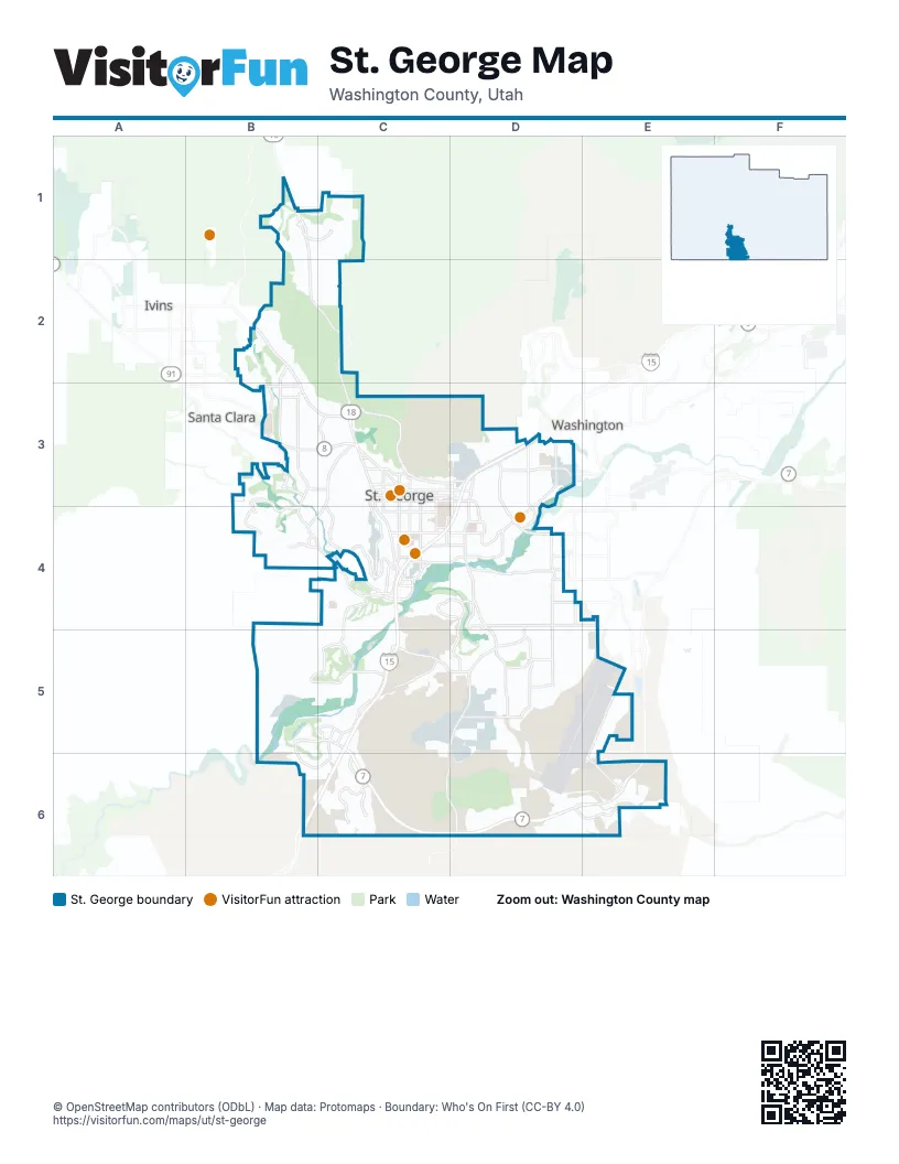
Street index of St. George
Each street on the sheet and the grid squares it crosses.
- Veterans Memorial HighwayD3, C4, D4, C5, B6, C6
- Southern ParkwayC5, C6, D6, E6
- Red Hills ParkwayC3, D3
- River RoadD3, D4, D5, C6, D6
- Snow Canyon ParkwayB2, B3, C3
- Dixie DriveB3, B4, C4
- Bluff StreetC3, C4
- Highway 18B1, B2, C2, C3
- Saint George BoulevardC3, D3
- East Riverside DriveD3, D4
- East Brigham RoadC5, D5
- Red Cliffs DriveD3
- Sunset BoulevardB3, C3
- Riverside DriveC4, D4
- North 3050 EastD3
- 1000 EastD3, D4
- West Brigham RoadC5
- East Saint George BoulevardD3
- South 3000 EastD4, D5
- Pioneer RoadC5
- Mall DriveD3, D4
- East 2450 SouthD4, E4
- Sun River ParkwayB5, C5
- George Washington BoulevardD4
- Valley View DriveC3, B4, C4
- Main StreetC3, C4
- 100 SouthC3, D3
- Dixie Downs RoadB3
- Temple StreetC3, C4
- Foremaster DriveD4
- University AvenueC3, C4
- 700 SouthC4
- Black Ridge DriveC4
- 2000 NorthB3
- South River RoadD5
- Skyline DriveC3
- East 100 SouthD3
- East 700 SouthC4, D4
- South Dixie DriveC4
- South Crosby WayC4
- Flyers LandingC4
- South 270 EastC4
- Gateway DriveD3
- Pioneer ParkwayB3
- South Sandia RoadD4
- Airport ParkwayE5, E6
- Desert Color ParkwayC5, C6
- Bloomington DriveB5, C5
- Sunbrook DriveB3, B4
- Tuweap DriveB2, B3
- Desert Canyons ParkwayD6, E6
- Little Valley RoadD5
- Ledges ParkwayB1, C1
- Tabernacle StreetC3, D3
- Indian Hills DriveC3, C4
- South Hidden Valley DriveC5
- East Commerce DriveC5, D5
- Carnelian ParkwayC6
- Painted Ridge ParkwayC6
- Bloomington Hills DriveD4, D5
- Quarry Ridge DriveD5
- Tech Ridge DriveC4
- Tonaquint DriveC4, C5
- Lava Flow DriveB3
- Trailblazer BoulevardC4
- Stonebridge DriveB3, C3
- Flood StreetC3, C4
- 600 SouthC4
- Diagonal StreetC3
- East 450 NorthD3
- Gap Canyon ParkwayB3, B4, C4
- East 900 SouthC4, D4
- 400 SouthC4, D4
- Auto Mall DriveC4
- Angel Arch DriveB5, B6, C6
- East 2000 SouthD4
- Horseman Park DriveD5
- Cloud DriveC4
- North 2450 EastD3
- 300 WestC3, C4
- Lagoon ParkwayC6
- 200 NorthC3
- South 3430 EastD4, D5
- 100 NorthB3, C3
- Sunland DriveC4
- Divario Canyon DriveB4
- 1400 WestC3
- Man O War RoadC5
- East 3580 South StreetD5
- Arrowhead Canyon DriveC5, C6
- 900 SouthC4
- Canyon View DriveB4, C4
- East Fort Pierce DriveC4, D4
- Cinder Bluffs ParkwayB1, C1
- Medical Center DriveD4
- 900 EastC3, C4
- 500 NorthC3
- South 1400 EastD4
- Bluegrass WayC5
- South Convention Center DriveC4
- Country LaneB3
- 1160 SouthC4
- East 2800 SouthD5
- South 900 EastC4
- 700 NorthB3, C3, D3
- 250 WestC4
- Dinosaur Crossing DriveD4
- South 2450 EastD3, D4
- South 1470 EastD3, D4
- Country Club DriveC5
- South Tech Ridge DriveC3, C4
- 600 WestC3, C4
- East 4130 SouthD5
- Fort Pierce DriveC4, D4
- 1800 NorthB3
- Hope StreetC3
- East Deseret DriveD3
- South 400 EastC4
- North Fort Pierce DriveD4
- 1670 South StreetC4
- Ostler WayB4
- East 1130 SouthD4
- East 3650 SouthD4
- Valley Springs DriveD5
- South 2500 EastD4, D5
- North Tech Ridge DriveC3
- West 4200 SouthD4
- Washington Fields RoadE5
- Fort Pierce Drive NorthC4
- North Canyon View DriveB3
- Industrial DriveD3
- West Merrill RoadD4
- West 3090 SouthD4
- The Cliffs at Snow CanyonB2
- South 2350 EastD4, D5
- Cottonwood Springs RoadC3, D3
- White Dome DriveC6, D6
- Sugar Leo RoadC5
- East Crimson Ridge DriveD5
- Painted DesertD4, D5
- 100 EastC3, C4
- 200 SouthC3, C4, D4
- 1300 WestB1, C3, C4
- 100 WestC3, C4
- 500 SouthC4, D4
- Westridge DriveB3, C3
- East 2930 SouthD5, E5
- Donlee DriveC3, C4
- Cobalt DriveD4
- Middleton DriveD3
- Old Faa AirportD5, E5
- 2100 WestB2, B3
- Sir Monte DriveC4
- South 3210 EastD4, D5
- Honeycomb DriveD6
- Tacheene DriveB2
- 540 NorthB3, C3, D3
- East Venture DriveC5, D5
- 400 WestC3, C4
- Entrada TrailB2
- Banded Hills DriveD5, E5
- 300 EastC3, C4
- Flowers DriveD6
- 600 EastC3, C4
- Vermillion AvenueC4
- 500 EastC3, C4
- 1100 WestC3, C4
- Horizon View DriveB5, B6
- South 1630 EastD5
- Anasazi TrailB2, B3
- East Rimrunner DriveD6, E6
- Escalante DriveC5
- 200 WestC3, C4
- Grapevine DriveB6, C6
- South 1700 EastD4, D5
- Canyon Tree DriveB1, C1
- South 2580 EastD4
- Desert Sands at Painted DesertD5
- East 350 NorthD3
- St. James LaneC4, D4
- East Enterprise DriveC5, D5
- Yant Flat DriveD6
- Industrial RoadD3
- Mountain TrailD6
- Lizzie LaneC4, D4
- Hayrocks DriveD6
- 360 NorthB3, C3
- South Five Sisters DriveD4
- West 3780 SouthB5, C5
- North 2200 EastD3
- Sunshine TrailD6
- Navajo DriveB5, C5
- East 40 NorthD3
- North 2720 EastD3
- River Crest TownhomesD4
- Long Sky DriveB1
- 2780 EastD4
- Chaco TrailB2
- Shadow Point DriveC3
- South Eastridge DriveD3, D4
- Red Rock RoadD3
- Foxborough TownhomesD3
- Desert Hills DriveC5
- Scarlet Hill DriveC6
- North 2000 EastD3
- Tamarisk DriveD5
- West Whitestone DriveB6, C6
- 1250 NorthC3
- Factory DriveC5, D5
- South 1100 EastD4
- Stone Cliff ParkwayD4
- 1650 WestB3
- 1210 WestC3, C4
- Stone Mountain DriveC3
- East 2890 South StreetD5, E5
- Silver Cloud DriveB1
- Mulberry DriveC5
- South 2880 EastD5
- Ironwood DriveB5, B6
- South Morningside DriveC4
- East Granite WayD4
- Curly Hollow DriveC4
- 1200 NorthB3, C3, D3
- Artesia DriveB3, C3
- Desert Rose ApartmentsD3
- Paiute RoadB5
- 300 NorthC3
- Seegmiller DriveD5
- Bonita Bay DriveB5, B6
- Southgate Hills DriveC4
- Petroglyph DriveB1
- Ashbury LaneD4, E4
- Rock Rose DriveC6
- Pinyon DriveC6
- East Broken Mesa DriveD6
- Redwood Tree StreetD5
- 1700 EastD3
- White Canyon DriveD6
- East 2540 SouthD5
- Village RoadB4
- Desert Sage ParkwayC6
- East 850 NorthD3
- 1680 EastD3
- 400 NorthC3
- Cascade Canyon DriveB2, B3
- East Cliff Point DriveD4
- South 2640 East StreetD5
- 2130 WestB3
- Alienta DriveB4
- East 3100 South StreetD5, E5
- 500 WestC3
- Sienna Canyon at Webb HillD4, D5
- Copper Cliff DriveD5
- North 2750 EastD3
- South 2200 EastD3, D4
- East Rasmussen DriveD4
- Emeraud DriveB3
- Virgin DriveC5
- Boulder Springs DriveD4
- Province WayC4
- West Morane Manor DriveB6, C6
- Ridge View DriveC3
- East 140 SouthD3
- 1230 NorthB3, C3
- Manzanita RoadC5
- West Heather Glen DriveB6, C6
- South 3430 East StreetD5
- South 1450 EastD4
- Larkspur RoadC4, D4
- 750 NorthB3, C3
- Wesley Powell DriveC5
- North Star DriveB3
- View Point DriveD4
- East 3050 South StreetD5, E5
- South Crestline DriveD3, D4
- Sunstar DriveB5
- 1620 WestB3
- Bentley RoadD5
- East 50 SouthD3
- The Palms Mobile Home ParkD3
- East Amaranth DriveD5
- Rustic DriveD5
- South Hamilton DriveD6
- East 3670 SouthD5
- South 2240 East StreetD5
- 2190 WestB3
- East 3230 South StreetD5
- East 3850 SouthD5
- Legacy DriveC4
- East 750 NorthD3
- East 620 NorthD3
- Cecita WayB4
- East 3770 South StreetD5
- East Seegmiller DriveD5
- Knolls DriveD5
- Boulder Springs VillasD4
- North 2040 EastD3
- Del Mar DriveC5
- Pinnacle DriveD4
- Jacob Hamblin DriveC5
Things to do on the St. George map
Places on the map
- 2450 East Park
- Adventure Storage
- Ancestor Square
- Arizona Inspection Station
- Atkinville Wash Park
- Bloomington Country Club
- Bloomington Hill
- Bloomington Hills North Park
- Bloomington Park
- Commerce Pointe
- Crimson View Elementary School
- Desert Canyons Elementary
- Desert Hills High School
- Dixie Center
- Dixie Commons
- Dixie High School
- Dixie Red Hills Golf Club
- Entrada at Snow Canyon Country Club
- Kentucky Lucky Chicken
- Monster Boat and RV Storage
- Pioneer Park
- Red Cliffs Mall
- Siler Loop
- Smith's Marketplace
- Snake Hollow Bike Park
- Southgate Golf Course
- St. George Golf Club
- St. George Regional Airport
- St. George Training Area
- Sun River Golf Club
- Sunbrook Golf Club
- Sunbrook Ranch
- Sunset Plaza
- The Canyons Complex
- The Fields at Little Valley
- The Ledges Golf Course
- Tonaquint Park
- Utah Inspection Station
- Utah Tech University
- White Dome Nature Preserve
Next to St. George
- Green Spring
- Ivins
- Santa Clara
- Washington
© OpenStreetMap contributors, Open Database License, openstreetmap.org/copyright · Map data: Protomaps · Boundary: Who's On First (CC-BY 4.0); Quattroshapes (CC BY 2.0)