

Utah map
Washington County map
About 207,943 people live here (Census Bureau, 2024 estimate). The sheet's index lists 300 streets; West 100 North, West 100 South and Veterans Memorial Highway cross the most grid squares. Things to do inside the boundary: Angels Landing, Arts to Zion Art and Studio Tour and Ascent Air Charter.
Open the map (PDF, US Letter)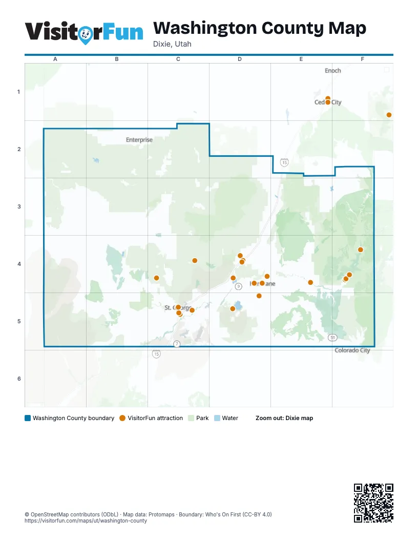
Maps inside Washington County
1 map inside, from the street map of Washington County down.
Street index of Washington County
Each street on the sheet and the grid squares it crosses.
- Veterans Memorial HighwayE2, D3, E3, C4, D4, C5
- Southern ParkwayD4, C5, D5
- Old Dixie Highway 91B4, B5
- Highway 9D4, E4
- Highway 18C4, C5
- West State StreetD4
- Red Hills ParkwayC5
- North Main StreetD2, B3, B4, C4, D4, C5
- River RoadF4, C5
- Snow Canyon ParkwayC4, C5
- Old Highway 91B4, C4, C5
- Dixie DriveC5
- Bluff StreetC5
- East Telegraph StreetD4, C5, D5
- Zion Park BoulevardF4
- Old US Highway 91A5, B5
- Toquerville ParkwayD4
- Toquer BoulevardD4
- West Main StreetB2, C3, E4, F4
- Saint George BoulevardC5
- South Main StreetD2, B3, C4, D4, C5
- East Main StreetB2, C3, F4
- North State StreetD4
- East Riverside DriveC5
- East Brigham RoadC5
- East 100 SouthB2, C3, C4, D4, C5
- Red Cliffs DriveC5
- Sunset BoulevardC5
- Santa Clara DriveC5
- West 500 NorthB3, D4
- Riverside DriveC5
- West Telegraph StreetC5
- South State StreetD4
- North 3050 EastC5
- East 500 NorthD2, B3, D4, C5
- 1000 EastD4, C5
- West Brigham RoadC5
- East Saint George BoulevardC5
- Short Creek–Fredonia HighwayF5
- East State StreetD4
- Highway 91A5
- Zion Park Scenic BywayE4, F4
- South Green Spring DriveC5
- Warner Valley RoadC5, D5
- Gunlock RoadB4
- Zion–Mount Carmel HighwayF4
- Main StreetB4, E4, C5, E5
- West Center StreetB3, B4, C4, D4
- West 600 NorthD4
- South 3000 EastE3, C5
- Sand Hollow RoadD4, D5
- North Gunlock RoadB3, B4
- Bench RoadC2, E5
- South Washington Fields RoadC5
- Washington Fields RoadC5
- Center StreetB2, D2, C4, D4, F4
- Pioneer RoadD4, C5
- Mall DriveC5
- South 700 WestB3, D4, E4, C5, D5
- East 2450 SouthC5
- East Center StreetB3, C3, C4, D4
- South 1100 WestD4, D5
- Valley View DriveF4, C5
- South 300 EastC3, C5
- North Washington ParkwayC5
- Sun River ParkwayC5
- George Washington BoulevardC5
- Pioneer ParkwayC5
- 100 SouthD2, C5
- East George Washington BoulevardC5
- Green Spring DriveC4, C5
- Red Mountain BoulevardC4, C5
- North 3700 WestD4
- West 3000 SouthD5
- Dixie Downs RoadC5
- East Buena Vista BoulevardC5
- Temple StreetC5
- Foremaster DriveC5
- West Buena Vista BoulevardC5
- Silver Reef RoadD4
- South Sand Hollow RoadD4
- Park View DriveD4, C5
- 3000 SouthD5
- University AvenueC5
- North 2800 WestD4
- 700 SouthC5
- South 1150 WestD4, D5
- Black Ridge DriveC5
- 2000 NorthC5
- East 600 NorthD4, C5
- North Green Spring DriveC5
- South River RoadC5
- Airport RoadC5, D5
- West Sandia RoadC5
- East Sandia RoadC5
- Skyline DriveC5
- East 700 SouthC5
- South Dixie DriveC5
- Cemetery RoadD4
- North Toquer BoulevardD4
- West George Washington BoulevardC5
- South Crosby WayC5
- Flyers LandingC5
- 3900 EastE2
- Zion Park Boulevard (Entrance Lane)F4
- South 270 EastC5
- Gateway DriveC5
- West 2000 SouthC5
- Zion Park Boulevard (Exit Lane)F4
- South Sandia RoadC5
- South Toquer BoulevardD4
- Kolob Terrace RoadF2, E3, F3, E4
- North 100 EastC3, D3, E3, C4, D4, C5
- Pine Valley RoadC3, D3
- Zion Canyon Scenic DriveF4
- North 6300 WestD4
- Kolob Canyons RoadE3
- Horseman Park DriveC3, C4, C5
- Snow Canyon DriveC4, C5
- Uzona AvenueE5, F5
- Kolob Carqua RoadE3
- West 100 NorthB2, D2, C3, B4, C4, D4, C5
- West 100 SouthB2, D2, B3, C3, C4, D4, C5
- East Washington Dam RoadC5, D5
- Regional Park RoadD4, D5
- Airport ParkwayC5
- South 400 WestB3, C3, C4, D4, E4, C5
- Pine Valley Highway EastC3
- North 5300 WestD4
- Desert Color ParkwayC5
- Bloomington DriveC5
- West 400 SouthB3, B4, C4, D4, C5
- Tuweap DriveB4, C5
- Kwavasa DriveB4
- South 200 WestB2, C3, C4, D4, C5
- Indian Hills DriveC5
- 1700 NorthB2, C2, D4, C5
- Sunbrook DriveC5
- Kayenta ParkwayB4
- North Taviawk DriveB4, C4
- North 200 WestC3, C4, D4, C5
- Ledges ParkwayC4
- Sand Hollow Resort ParkwayD5
- Lava Flow DriveC5
- South 100 EastC3, C4, D4, C5
- Desert Canyons ParkwayC5
- Dixie Springs DriveD5
- East 900 SouthD3, C5, E5
- 2100 West StreetD5
- 100 NorthB2, C5
- North Coral Canyon RoadD4, D5
- 400 SouthB2, C4, C5
- Little Valley RoadC5
- Diamond Valley DriveC4
- Washington ParkwayC4, C5
- Grafton RoadE4, F4
- Tabernacle StreetC5
- Rlington ParkwayD4
- 1100 WestC5, D5
- West Utah AvenueF5
- Fairway DriveC4, C5
- South Hidden Valley DriveC5
- South 300 WestB3, C3, C4, D4, C5
- East Commerce DriveC5
- Carnelian ParkwayC5
- Painted Ridge ParkwayC5
- Bloomington Hills DriveC5
- South West Field RoadD4
- North 300 WestC3, C4, D4, C5
- Quarry Ridge DriveC5
- Rachel DriveC4, C5
- East 400 SouthD2, D3, C4, D4, C5
- 400 East StreetC4, C5
- Tech Ridge DriveC5
- Tonaquint DriveC5
- Flood StreetF4, C5
- North Canyon View DriveC5
- Trailblazer BoulevardC5
- South 2500 EastE3, C5
- Stonebridge DriveC5
- East 450 NorthD4, C5
- Bridge RoadF4, F5
- South 3430 EastE3, C5
- South 3400 WestD5
- Flora-Tec RoadD4
- North 400 WestD2, B3, C3, C4, D4
- 600 SouthC5
- Diagonal StreetC5
- North 300 EastB2, C3, D4, C5
- Grapevine Crossing RoadC5, D5
- Gap Canyon ParkwayC5
- 300 WestB2, D4, C5
- South 400 EastD2, C3, C5
- Country LaneC5
- North 3400 WestD4
- Bash ParkwayD4
- North 2600 WestD4
- East 2000 SouthC5
- Auto Mall DriveC5
- Angel Arch DriveC5
- 400 EastB2, D2, C4
- Gateway BoulevardD4, D5
- 1400 WestC4, C5
- North 1100 EastD2, C5
- Cloud DriveC5
- Canyon View DriveF4, C5
- Industrial DriveD4, C5
- Long Valley RoadD5
- North 2450 EastC5
- Concord ParkwayC4, C5
- West Washington ParkwayC4
- Lagoon ParkwayC5
- 200 NorthC5
- Wintook DriveB4
- South 5300 WestD4
- Evening Star DriveB4, C4
- South 1760 WestD4
- Sunland DriveC5
- Divario Canyon DriveC5
- Man O War RoadC5
- South Puerto DriveC4
- Weatherby WayC5
- 500 NorthD4, C5
- West Merrill RoadC5
- East 3580 South StreetC5
- Arrowhead Canyon DriveC5
- East 2800 SouthE3, C5
- 900 SouthC5
- East Fort Pierce DriveC5
- Cinder Bluffs ParkwayC4
- Medical Center DriveC5
- 900 EastC5
- South 2450 EastE3, C5
- South 900 EastC3, C5
- East Utah AvenueF5
- North 700 WestD4
- North 2260 WestD4
- South 1400 EastC5
- Bluegrass WayC5
- E Ara ParkwayC5
- South Convention Center DriveC5
- Gubler DriveC5
- 700 NorthD4, C5
- North Hildale StreetF5
- East Merrill RoadC5
- North Town RoadC4
- 1160 SouthC5
- South 240 WestC5
- 240 WestC5
- East 4200 SouthC5
- East 3090 SouthC5
- 250 WestC5
- North 870 WestD4
- West 3090 SouthC5
- Dinosaur Crossing DriveC5
- South 3410 EastC5
- South 1470 EastC5
- North 1150 WestD4
- Country Club DriveC5
- North Coral Canyon BoulevardD4
- South Tech Ridge DriveC5
- 600 WestC5
- East 4130 SouthC5
- Fort Pierce DriveC5
- 1800 NorthC5
- Hope StreetC5
- East 3650 SouthC5
- North Commerce BoulevardC5
- East Deseret DriveC5
- North Central StreetF5
- West 720 SouthD4
- Hayfield DriveC5
- North Fort Pierce DriveC5
- 1670 South StreetC5
- Ostler WayC5
- East 1130 SouthC5
- Richard StreetF5
- West 4200 SouthC5
- Valley Springs DriveC5
- Snow Canyon RoadC4, D5
- Snow Canyon Drive (Exit Lane)C4
- Snow Canyon Drive (Annual Pass Entrance Lane)C4
- Snow Canyon Drive (Entrance Lane)C4
- North Tech Ridge DriveC5
- Fort Pierce Drive NorthC5
- West Field RoadD4
- West Canyon View DriveC5
- Coral Canyon BoulevardD4
- North Richard StreetF5
- Snow Canyon Drive (Entry Lane)C4
- Kolob Resevoir RoadE4
- New Castle-Pine Valley RoadC2, C3
- Motoqua RoadA3, A4, B4
- Mesa RoadE3, E4
- Leeds Creek-Cottonwood RoadC4, D4
- Colie Flat RoadA2, B2, A3
- Veyo Shoal Creek RoadB2, B3
- Crestline RoadA2, B2
- West Pinto RoadC2, D2
- Cane Springs Canyon RoadA3
Things to do on the Washington County map
- Angels Landing
- Arts to Zion Art and Studio Tour
- Ascent Air Charter
- ATV Offroad Adventures
- Dig Paddlesports
- Fiesta Fun Center
- Greater Zion
- Greater Zion E-Bikes
- McQuarrie Memorial Museum
- Red Rock Humvee Tours
- Red Rock Shuttle
- Red Rock SxS Tours
- Sand Hollow Rentals
- Silver Reef Museum
- SoTah Adventures
- Southern Utah Adventure Center
- St. George Dinosaur Discovery Site at Johnson Farm
- Tuacahn Center for the Arts
- Utah Adventure Center
- UTV Adventure Tours
- Washington County Museums
- Zion Balloons
- Zion Canyon Hot Springs
- Zion Helicopters
- Zion Jeep Tours
- Zion National Park
- Zion Vineyards
Places on the map
- Angels Landing
- Apple Valley
- Ash Creek Reservoir
- Beaver Dam Wash
- Beaver Dam Wash National Conservation Area
- Black Desert Golf Course
- Black Desert Resort
- Blackridge Wilderness
- Bloomington Country Club
- Blue Springs Reservoir
- Bupstarch Loop
- Canaan Mountain Wilderness
- Candy Cliffs
- Central
- Confluence Park
- Copper Rock Golf Course
- Coral Canyon Golf Course
- Cottonwood Canyon Wilderness
- Cougar Canyon Wilderness
- Dammeron Valley
- Deep Creek North Wilderness
- Deep Creek Wilderness
- Doc's Pass Wilderness
- Enterprise
- Grafton Historic DIstrict
- Gravel Pit
- Green Spring Golf Course
- Guacamole Trail
- Gunlock Reservoir
- Gunlock State Park
- Hildale
- Pine Valley Mountain Wilderness
- Red Cliffs National Conservation Area
- Red Mountain Wilderness
- Sand Hollow Resort
- Sand Mountain OHV Area
- Santa Clara River Reserve
- Snow Canyon State Park
- Zion National Park
- Zion Wilderness
Next to Washington County
- Cedar City
- Colorado City
- Enoch
© OpenStreetMap contributors, Open Database License, openstreetmap.org/copyright · Map data: Protomaps · Boundary: Who's On First (CC-BY 4.0); Quattroshapes (CC BY 2.0)