

Virginia map
Front Royal map
About 15,628 people live here (Census Bureau, 2024 estimate). The sheet's index lists 300 streets; Happy Creek Road, North Commerce Avenue and John Marshall Highway cross the most grid squares. Also on it: Gateway Plaza, Prospect Hill Cemetery and Royal Plaza.
Open the map (PDF, US Letter)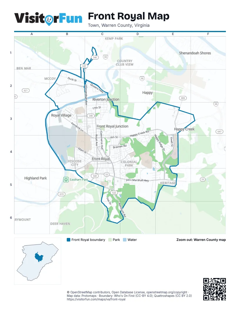
Street index of Front Royal
Each street on the sheet and the grid squares it crosses.
- North Commerce AvenueC3, C4, C5
- John Marshall HighwayC5, D5, E5
- North Shenandoah AvenueC2, C3
- North Royal AvenueC2, C3, C4
- Remount RoadC5, C6, D6
- West Strasburg RoadB2, C2
- West 14th StreetB3, C3
- South Royal AvenueC4, C5
- South StreetC5
- South Commerce AvenueC4, C5
- Winchester RoadC1, C2
- Strasburg RoadB2
- Happy Creek RoadD3, E3, F3, C4, D4
- Leach Run ParkwayE3, E4, E5
- Kendrick LaneB3, C3, C4
- East 6th StreetC4, D4
- East Main StreetC4
- West 6th StreetC4
- East Stonewall DriveC4, D4
- Luray AvenueB4, C4, B5
- Shenandoah Shores RoadE3
- West Main StreetB4, C4
- East Criser RoadC5
- Kerfoot AvenueB4, B5
- West Criser RoadB5
- Chester StreetC4
- East Jackson StreetC4
- Massanutten AvenueB3
- West Jackson StreetC4
- East 3rd StreetC4
- Laura Virginia Hale PlaceC4
- Guard Hill RoadB1
- Manassas StreetC4
- Virginia AvenueC3, C4
- West 11th StreetB3, C3
- Westminster DriveD4, D5
- Manassas AvenueC3, C4
- West 13th StreetB3, C3
- West Duck StreetB2, C2
- West 15th StreetB3, C3
- Warren AvenueC3, C4
- Washington AvenueC3, C4
- Kesler RoadB2
- Jamestown RoadD4, D5
- Happy Ridge DriveD3, E4
- Locust Dale RoadD5, D6
- Braxton RoadC4, D4
- Ewell StreetE3, E4
- Old Belmont RoadC5, C6
- Salem AvenueB4, C4
- West Commonwealth DriveE5
- South Shenandoah AvenueB4
- Randolph AvenueC3, C4
- Cleveland RoadE3, F3
- Fox DriveC5, C6
- Walker AvenueD4, E4, E5
- Edgemont AvenueC2, C3
- East 7th StreetC3
- Lewis StreetD3, D4
- Heritage DriveE4
- West 9th StreetB3, C3
- South Marshall StreetD4
- Summit DriveD5
- Academy DriveC4
- Belmont AvenueC2, C3
- East Prospect StreetC4
- Mary's Shady LaneD3
- Queens HighwayC2
- West 12th StreetB3, C3
- Belair AvenueC3, C4
- Brown AvenueB4
- Cloud StreetC4, C5
- Villa AvenueC3, C4
- South Charles StreetD4, D5
- East 8th StreetC3
- Blue Ridge AvenueC4, C5
- Overlook DriveB4, B5, C5
- Stuart DriveD3, D4
- Portsmouth RoadC5, D5
- Henrico RoadD4, D5
- Richmond RoadD5
- Old Winchester PikeC2
- Polk AvenueC4, D4
- Lee StreetC4, C5
- Swan RoadD3, D4
- Shenandoah Commons WayD5
- Gloucester RoadD5
- Fairview AvenueC3
- Woodside AvenueB3, C3
- Viscose AvenueB4
- Short StreetC5
- Cherrydale AvenueB4, B5
- Horseshoe DriveD4
- Grand AvenueB4, C4
- East 17th StreetC3
- West 1st StreetC4
- Rodney AvenueC4, D4
- Jefferson AvenueB3
- Duncan AvenueB4, B5
- Linden StreetD5, E5
- Progress DriveE3
- Goodview DriveD3, D4
- East 19th StreetC2, C3
- East 18th StreetC3
- Scranton AvenueC2, C3
- Canterbury RoadD4, E4, E5
- West 18th StreetC3
- Water StreetC4
- Monroe AvenueB3
- Adams AvenueB3
- Aqueduct LaneC5, D5
- William StreetD4
- Deer PathD5, E5
- Meadow CourtD4
- Accomac RoadD4, D5
- West 17th StreetC3
- West 8th StreetC3
- South Fork DriveB2
- Beeden LaneC5
- East 4th StreetC4
- East 5th StreetC4
- West Stonewall DriveC4
- Forest Hill DriveB2
- Wine StreetD4
- Church StreetC4
- Acton StreetC5
- Valley View DriveB2
- River DriveB4, B5
- Stockton RoadC4, D4
- Sycamore LaneD4
- West 16th StreetB3, C3
- Old Strasburg RoadB2
- Crosby RoadC3, C4
- Oden StreetE4
- Pinecrest StreetD4
- Fulton LaneB2
- Orchard StreetB4, C4
- Ross AvenueC4
- High StreetC4
- Markham StreetD5, E5
- West 10th StreetB3, C3
- Clymer AvenueC4
- Front StreetC4, C5
- Royal LaneD5
- Meadow LaneD3, D4
- Union StreetC4
- Oakmont DriveD5
- Anderson StreetD5, E5
- Hamilton CircleC4
- Hill StreetC5
- Stadium DriveC3
- Fletcher StreetC4
- Elsia DriveC5
- Industrial RoadE3
- East 2nd StreetC4
- Osage StreetC4, C5
- Bass AvenueC4, D4
- East Strasburg RoadC2
- Frederick AvenueC4, D4
- Pine StreetC4, C5
- Druid HillB4, C4
- North Charles StreetD4
- East 13th StreetC3
- Crisman DriveC2
- Transcend DriveB3
- North Easterly StreetD4
- Crestview DriveC3
- Mount View StreetC5
- Riverside DriveC2
- Warren County HSD4
- The HillC4
- Colonial DriveE5
- East 16th StreetC3
- Pullen StreetC4, C5
- Elm StreetD5
- Ritenour StreetC4, C5
- Cherry StreetC4
- Steele AvenueC5
- Cavalier DriveD4
- Crescent StreetC4
- Mission AvenueE3
- Village CourtE3
- Leach StreetD4
- Woodlawn AvenueD4
- East 15th StreetC3
- Family Life LaneE3
- Peyton StreetC4
- West 5th StreetC4
- West 4th StreetC4
- West 3rd StreetC4
- Cedar DriveB2
- Commonwealth AvenueB3
- Peakova LaneB4
- Creekside WayB2
- Pence StreetB4
- Hillcrest DriveB3
- Robinhood LaneD5
- Laurel StreetC5
- East 14th StreetC3
- Madison AvenueB3
- Depot AvenueC2
- Ay-View DriveC5
- Oak StreetC4
- Sherwood AvenueC4
- Esa LaneE5
- Bedford DriveD4
- South Easterly StreetD4
- Bee StreetC4
- Biggs DriveD5
- Oakridge CourtC4
- Ripple CourtB2
- McClendon DriveC5
- Mosby LaneC4
- Mills LaneC5
- Vista Ridge CourtD4
- New AvenueC3, C4
- Parkview DriveC5
- Lakeview DriveE4, E5
- Barton StreetC5
- Cannon StreetD4
- Hamilton AvenueC4, D4
- Northview AvenueD4
- Cemetery LaneC4
- Cresthaven CourtB5, C5
- Lena CourtD4
- Riverview StreetB2
- Bradford DriveC3, D4
- Morain StreetD4
- Highfield LaneC5, D5
- Midland AvenueC3, C4
- Wakeland CourtD3
- Summit AvenueC3
- North Marshall StreetD4
- Beau LaneC5, D5
- Mt Vernon CourtE5
- Rugby StreetB2
- Skyway DriveC5
- West Prospect StreetC4
- Ashlawn CourtE5
- Jackson LaneC5
- Carter StreetC5
- Skyline PlaceB4
- Amherst DriveD4
- Massie StreetC4
- Nottingham CourtE4
- Brook CourtB2
- Hillvue StreetD5
- Dodson LaneB2
- Stayman StreetC4, D4
- Midway AvenueC5
- Cable StreetC5
- Dixie AvenueB3
- State StreetB3
- View Crest CourtD4
- Windsor CourtD4, D5
- Scott StreetC5
- Highview StreetC5
- Shenandoah Heights RoadE4
- West 7th StreetC3
- West 2nd StreetC4
- Hill Top CourtB2
- Park LaneC3
- North StreetC4
- Cypress StreetB4, C4
- Ridge RoadD5
- Buckingham CourtD4
- Auburn CourtD4
- South Lake AvenueE5
- Highland StreetC5
- Cable PlaceC5
- Locust StreetB2
- Longhill RoadE5
- River Bend CourtB2
- North Lake AvenueE5
- Tourist StreetC5
- Hillidge StreetC4
- Kendrick Ford RoadB2
- Pow-Morr DriveC5
- Turners LaneC4
- Downing StreetC4
- Garrison AvenueB4
- East Duck StreetC2
- Town Hall Drive ThroughC4
- Yorktown CourtD4, D5
- Evelyn CourtD4
- Kibler StreetC3, C4
- Proctor LaneC5
- Lillard DriveC5
- Cook LaneC4
- Devin CourtD5
- Garden CourtD3, D4
- Ryder Benson LaneC5
- Eric CourtD4
- Jocelyne CourtD4
- Frazer PlaceC5
- Edgewood StreetC4
- Houghs WayE3
- Loop RoadE3
- Radham StreetC4
- Little League LaneC3
Places on the map
- 7-Eleven
- A&J Narron Antiques
- Advance Auto Parts
- Alvin Stokes General Store
- American Legion Hall
- Andrick's Front Royal Flea Market
- Baymont
- Better Thymes Natural Foods
- Bing Crosby Stadium
- Blue Ridge Hospice
- Blue Ridge Motel
- Blue Wing Frog
- Boost Mobile
- Budget Inn
- Chimney Field baseball field
- Chimney Field basketball court
- Chimney Field Park
- Chimney Field tennis courts
- Church of Christ
- Circle K
- Claude A. Stokes Community Swimming Pool
- Cool Harbor Motel
- CVS Pharmacy
- DL Campus Coffee
- Dynamic Life
- E. Wilson Morrison Elementary School
- Edge Hill
- Gateway Plaza
- Good Hope Cemetery
- Human Life International Endowment
- Prospect Hill Cemetery
- Royal Plaza
- Skyline Middle School
- Skyline Soccerplex
- The UPS Store
- Twin Rivers Campground
- Warren County High School
- Warren County Middle School
- Warren Memorial Hospital
Next to Front Royal
- Ben Mar
- Benny Megeath
- Country Club View
- Deer Haven
- Grandview Estates
- Green Hill Forest
- Happy
- Happy Creek
- Hensel Stone Woods
- Highland Park
- Kemp Park
- McCoy
- Merrymount
- Mineral Springs
- Riverton
- Shenandoah River Estates
- Shenandoah Shores
© OpenStreetMap contributors, Open Database License, openstreetmap.org/copyright · Map data: Protomaps · Boundary: Who's On First (CC-BY 4.0); Quattroshapes (CC BY 2.0)















