

Virginia map
Warren County map
About 42,461 people live here (Census Bureau, 2024 estimate). The sheet's index lists 300 streets; Skyline Drive, Stonewall Jackson Highway and Winchester Road cross the most grid squares. Things to do inside the boundary: Gimlet Ridge Overlook and Skyline Caverns.
Open the map (PDF, US Letter)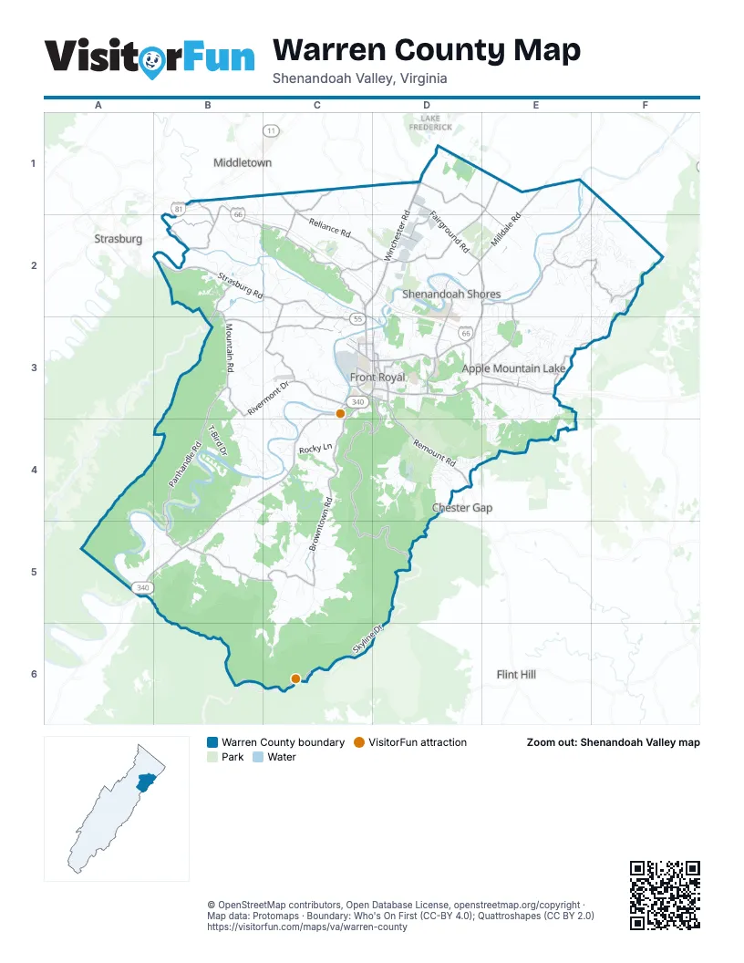
Maps inside Warren County
1 map inside, from the street map of Warren County down.
Street index of Warren County
Each street on the sheet and the grid squares it crosses.
- Winchester RoadD1, C2, D2, C3
- Stonewall Jackson HighwayD1, C3, B4, C4, A5, B5
- Strasburg RoadB2, C2, C3
- John Marshall HighwayD3, E3
- Remount RoadD3, D4
- North Commerce AvenueD3
- North Shenandoah AvenueC3
- North Royal AvenueD3
- West Strasburg RoadC3
- West 14th StreetC3, D3
- South Royal AvenueC3, D3
- South StreetD3
- South Commerce AvenueD3
- Valley PikeB1
- Apple Mountain RoadE3
- Front Royal PikeD1
- Old Valley PikeB1
- Front Royal RoadB2
- Skyline DriveC3, D3, C4, D4, C5, D5, B6, C6, D6
- Reliance RoadC1, C2, D2
- Happy Creek RoadD3
- Fairground RoadD1, D2
- Morgan Ford RoadD2, E2, D3
- Milldale RoadE1, D2, E2
- Leach Run ParkwayD3
- Kendrick LaneC3
- Stickley LaneD2
- East 6th StreetD3
- State Route 624E1
- East Main StreetD3
- Refuge Church RoadD1
- Zion Church RoadD1
- West 6th StreetC3, D3
- Double Church RoadD1
- Red Gate RoadE1
- Browntown RoadC3, C4, C5
- Howellsville RoadE1, F1, E2
- Rockland RoadE1, D2, E2
- Panhandle RoadB3, B4, B5
- Long Meadow RoadB1, B2, C2
- Bentonville-Browntown RoadB5, C5
- Blue Mountain RoadE2, F2
- Rivermont DriveB3, C3
- Mountain RoadB2, B3
- Guard Hill RoadC2
- Freezeland RoadF2, E3, F3
- Ashby Station RoadD1, E1, E2
- Dismal Hollow RoadD3, E3
- Shenandoah Shores RoadD2, D3
- Oregon Hollow RoadE2, D3, E3
- Kendrick Ford RoadC3
- Bowmans Mill RoadB2
- Wakeman Mill RoadB3, C3
- Fort Valley RoadB2, B3
- Stokes Airport RoadC3
- Cauthorn Mill RoadC1
- Ritenour Hollow RoadC2, D2
- Baugh DriveD1, D2
- East Stonewall DriveD3
- Indian Hollow RoadB5
- North River RoadC1, C2
- Water Plant RoadB1, B2
- Totten LaneC2, C3
- Luray AvenueC3, D3
- Laing RoadC3
- Toray DriveD2
- West Main StreetC3, D3
- East Criser RoadC3, D3
- Kerfoot AvenueC3
- Punch Run RoadC2, C3
- West Criser RoadC3
- Chester Gap RoadD4
- Chester StreetD3
- East Jackson StreetD3
- Massanutten AvenueC3
- East 3rd StreetD1, D3
- West Jackson StreetC3, D3
- Laura Virginia Hale PlaceD3
- Indian Hollow BridgeB5
- Bowmans Ford RoadB1
- Bowman Mill RoadB2
- East Refuge Church RoadD1
- Manassas StreetD3
- Gooney Manor LoopC5, B6, C6
- Buck Mountain RoadB4, C4, C5
- Harmony Hollow RoadD4
- Civilian Conservation Corps RoadE3, E4
- Gafia Lodge RoadB2, C2
- High Top RoadE2, E3
- Milldale Farm RoadE1, E2
- Catlett Mountain RoadC3
- Hazard Mill RoadA4, B4, A5, B5
- Mary's Shady LaneD2, D3
- Ridgeway RoadB3, C3
- Bucks Mill RoadB2, C2
- Bennys Beach RoadD2
- Riverton RoadC2, D2, D3
- Daughter of Stars DriveB4, B5
- Drummer Hill RoadF2
- Rocky Hollow RoadA5, B5
- Smith Run RoadC5
- Khyber Pass RoadE3
- Thompson Hollow RoadB5
- T-Bird DriveB4
- Applewood DriveD3, E3
- Morgans Ford Farm RoadE2
- McCoys Ford RoadB3, B4
- Old Linden RoadF2, E3, F3
- Rivinus RoadD4
- Longhill RoadD3, D4
- Venus Branch RoadF2
- Pilgrims WayA4, B4, B5
- Western LaneE2, F2
- Old Oak LaneF1, F2
- Massanutten Mountain DriveD3, E3, D4
- Poor House RoadC4
- Steed LaneB3, C3
- Riverview Shores DriveD2
- Rocky LaneC4
- Stoney Bottom RoadB4, C4
- Reynolds DriveE2, F2
- Springwood LaneC1, C2
- Wapping Farm RoadE3
- Whitney LaneB4, B5
- Highridge RoadD4
- Fire Trail RoadF2
- Hillandale RoadD3
- Bowman Hollow RoadC1, D1
- Bowling Green RoadD2, E2
- Andrews RoadC2
- Summit Point DriveD4, E4
- South River RoadC3
- Fiery Run RoadE3, E4
- Granny Smith RoadE3
- King David DriveE3
- Downing Farm RoadB4, C4
- Mountain Heights RoadD4
- Rawley Ridge DriveC4
- Rivermont Acres RoadC3
- Liberty Hall RoadC5
- Dodson LaneC2
- High Knob RoadD3, E3
- Thunder RoadB4
- Rocky Glen RoadD1
- Forest Grove RoadB2
- Pine Ridge DriveE2, F2
- Heirloom LaneE4
- Hunt RoadC2, C3
- Shadows DriveC2, D2
- Goode DriveE2, F2
- Arrowhead RoadB4
- Kendall CourtE2
- William Vincent RoadC5
- Shangri-la RoadB5
- Wildcat DriveE2, E3
- Mosby Spring RoadE4
- Virginia AvenueC3, D3
- River Ridge DriveC2
- Poca Bella DriveC4
- Esteppe RoadC3
- Meade RoadD4
- Greatland Farm DriveB2
- Fetchett RoadC5
- Sunset Village RoadC3
- Lands Run RoadC5
- Milldale Hollow RoadE1, E2
- Lower Valley RoadB2
- Sulphur Spring RoadB1, B2
- Fox Hollow Farm RoadC5
- Bifrost WayE3
- West Duck StreetC2, C3
- Kildare DriveE2
- Wilderness RoadE3
- Eagle DriveB4
- Apple Orchard DriveE3
- Osprey LaneC3, C4
- Doom Peak RoadE3
- Harmony Orchard RoadD4
- Misty Meadow LaneA5
- Apple Jack CircleE3
- Bowling View RoadD2, E2
- West 11th StreetC3, D3
- Great Lake DriveB2
- Westminster DriveD3
- Acorn Hill RoadB5
- Country Club RoadD2
- Loop RoadD3
- Coldbrook LaneE2
- Megeath Farm LaneD2
- Windy WayE3, E4
- Dorn RoadC3, C4
- Little Egypt LaneC3
- Headquarter LaneC1, C2
- Manassas AvenueD3
- Sloats Mountain RoadE3
- Rock Hill Farm RoadE2
- Northern Spy DriveE3
- Cemetery RoadC2
- Pomeroy RoadD4
- Howellsville Heights CircleE2
- Lucke WayE3
- Boyds Mill LaneC5
- Slate Hill DriveD4
- Luchase RoadE3
- Ulysses WayE3
- Rocky Spring LaneF2
- Richardson RoadB2
- Reid DriveF2
- Wendy Hill RoadE2
- Timberland Manor DriveB5, C5
- Moore RoadD4
- Lee Burke RoadC3, C4
- Bragg DriveE2, F2
- Catletts Ford RoadC2
- Shenandoah Valley DriveE4
- West 13th StreetC3, D3
- Overnight RoadB4
- Old Sawmill RoadF2
- Jonathan RoadE3
- Farms River RoadE2
- West 15th StreetC3, D3
- Alpine DriveE4
- Rollason DriveD2
- Creek RoadD4
- Old Dam RoadD2
- Youngs DriveE2
- Homestead DriveC2
- Club House RoadE3, E4
- McDaniel LaneB1, B2
- Warren AvenueD3
- Running Bear CourtB4
- Red Bud LaneD3, D4
- Stoney Mountain DriveB2
- Newton DriveE3
- Rome Beauty DriveE3
- Skyline Forest DriveC4
- Grimes Golden RoadE3
- Jones Farm RoadC4, B5, C5
- Washington AvenueD3
- Old Belmont RoadD3
- Point RoadB4
- Cardinal DriveD4
- Tulip Poplar DriveF2, F3
- Comforter LaneC2
- Southern DriveB2
- Kesler RoadC3
- Skyline View DriveE4
- Hidden View LaneC4
- Darby LaneB3, B4
- Harris DriveD2
- Steps to Heaven RoadE3
- Jamestown RoadD3
- Jennings LaneB5
- Oakview DriveB4
- Red Hille WayC5
- Salt Lick RoadE4
- Fontana RoadC4
- Happy Ridge DriveD3
- Ellen DriveD3, E3
- Windy Pines RoadB4, C4
- Locust Dale RoadD3
- Greenfield RoadD3
- Reliance LaneC1
- Rogers Mill RoadC2
- Vesey DriveF1, F2
- Simons WayC3
- Cooley DriveC2
- Cherokee Run RoadE3, E4
- Catron Ridge RoadB5
- Black Twig RoadE3
- Broad Run RoadC5
- Vaught DriveE2, F2
- Split Rail RoadE3, E4
- Messick RoadB2
- Avalon DriveD2
- Lake DriveE2
- Shannon Woods DriveD3, E3
- McDonalds Farm RoadF2, F3
- Curls RoadC4
- Karleys WayC1, C2
- Fishnet BoulevardD2
- Lakeside DriveB4
- Morgans Ridge RoadE2, E3
- Stonegate LaneD2
- Gruver Grade DriveC2
- Koa DriveC3, C4
- River Oak DriveB4
- Bear Hollow DriveD4
- Golden Russet DriveE3
- Dogwood Farm RoadE2, F2
- Beech RoadD2
- Old Oregon RoadE2, F2
- Gimlet Ridge RoadB5
- Ridge Hills RoadB5
- Chipmunk Trail LaneF2
- Limeton Church RoadB4
- Braxton RoadD3
- Thompsons Mill RoadE1, F1, F2
- Hidden Valley LaneC1, C2
- 4H Center DriveD4
Things to do on the Warren County map
Places on the map
- Appalachian National Scenic Trail
- Apple Mountain Lake
- Bear Bottom Loop Trail
- Blue Mountain Property Owners Association
- Blue Ridge Shadows Golf Club
- Bowling Green Country Club
- Cedar Creek
- Cedar Creek and Belle Grove National Historical Park
- Christendom College
- Divinum Auxilium Academy
- Eastham Park
- Front Royal
- Front Royal Golf Club
- Front Royal-Warren County Airport
- Gateway Plaza
- Glen Manor Vineyards
- Gooney Creek Salvage
- Grace Bible Fellowship
- Hidden Springs Senior Living
- High Knob Owners Association
- Lake John
- Low Water Bridge Campground
- Mountainview RV Campground
- North Fork Resort Associates
- Panorama Memorial Gardens
- Potomac Appalachian Trail Club
- Prospect Hill Cemetery
- Raymond R. "Andy" Guest, Jr. Shenandoah River State Park
- Riverton Commons
- Riverton Lime and Stone
- Riverton Lime Plant
- Rockland Park
- Royal Plaza
- RSW Regional Jail
- Shenandoah Farms
- Shenandoah Shores
- Shenandoah Valley Golf Club
- Skyland Estates
- Skyline High School
- The Dominican Nuns
Next to Warren County
- Chester Gap
- Flint Hill
- Lake Frederick
- Middletown
- Strasburg
© OpenStreetMap contributors, Open Database License, openstreetmap.org/copyright · Map data: Protomaps · Boundary: Who's On First (CC-BY 4.0); Quattroshapes (CC BY 2.0)















