

Washington map
Camas map
About 27,313 people live here (Census Bureau, 2024 estimate). The sheet's index lists 300 streets; Northwest Larkspur Street, Lewis and Clark Highway and Northwest Ivy Street cross the most grid squares. Things to do inside the boundary: Downtown Camas.
Open the map (PDF, US Letter)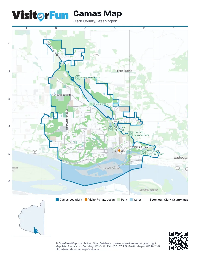
Street index of Camas
Each street on the sheet and the grid squares it crosses.
- Lewis and Clark HighwayC5, D5, E5, D6
- Southeast Lewis and Clark HighwayB5, C5
- Northeast 3rd AvenueD5, E5
- Northwest 6th AvenueC5, D5
- Northeast 6th AvenueD5
- Northeast Adams StreetD4, D5
- E StreetE5
- Northwest Lake RoadB3, C3, D4
- Northwest Parker StreetB3, B4
- Northeast Everett StreetD3, D4, D5
- Northwest Pacific Rim BoulevardB4
- Southwest 6th AvenueB5, C5
- Northwest Camas Meadows DriveB2, B3
- Northwest Brady RoadB4, B5
- Northeast Garfield StreetD3, D4, D5
- Northeast 28th StreetB2, C2
- Southeast 6th AvenueD5, E5
- Northwest Larkspur StreetB3, B4, C4, B5, C5
- Northeast Dallas StreetD4, D5
- Northeast Goodwin RoadB2
- Southeast 8th AvenueE5
- Northeast Lake RoadD4
- Northeast 14th AvenueD5
- Northeast 13th StreetB2
- Southeast Union StreetE5
- Southeast Everett RoadD3
- Southeast 10th AvenueE5
- Southeast Lechner StreetE5
- Southeast 34th StreetB4
- Northwest 38th AvenueB4, C4
- Northwest Astor StreetC3, C4, C5
- Northwest 18th AvenueB5, C5, D5
- Northwest 16th AvenueB5, C5, D5
- Northwest McIntosh RoadB5, C5
- Northeast Ingle RoadB1, B2
- Northwest 12th AvenueB5, C5, D5
- Northwest Dahlia DriveC3, C4
- Northwest 7th AvenueC5, D5
- Southeast Leadbetter RoadC3, D3
- Northwest 23rd AvenueC4, D4
- Northwest 10th AvenueC5, D5
- Northeast Woodburn DriveD4, E4
- Northwest Fargo StreetC4, D4, D5
- Northwest Forest Home RoadC4, C5, D5
- Northwest Leadbetter DriveB3, C3
- Northwest 43rd AvenueC3, C4, D4
- Division StreetD4, D5
- Northwest Friberg-Strunk StreetB2, B3
- Northeast 2nd AvenueD5, E5
- Northwest 28th AvenueC4
- Northwest Valley StreetC3, C4, C5
- Northwest Benton StreetD4, D5
- Northwest Cascade StreetC4, C5
- Northwest 29th AvenueB4, C4, D4
- Northwest Hood StreetC3, C4, C5
- Northwest Sierra StreetC3, C4, C5
- Northeast Leadbetter Westlake RoadC3
- Northwest 11th AvenueC5, D5
- Northeast 43rd AvenueD3
- Southeast 15th StreetD3, E3
- Northwest Drake StreetD5
- Northeast Everett DriveD3
- Northeast 15th AvenueD5
- Southeast Payne RoadB4, B5
- Southeast Crown RoadE4, E5
- Northwest Utah StreetC3, C4
- Southeast Bybee RoadB4
- Southeast Evergreen HighwayB5
- Northeast 232nd AvenueC2, C3
- Northwest 18th LoopD5
- Southeast Whitney StreetE5
- Northwest Tidland StreetB2, B5
- Northeast 199th AvenueB1
- North Shepherd RoadE5
- Northeast Whitney StreetE5
- Southeast 283rd AvenueE4
- 3rd StreetE5
- North Lebrun DriveE5
- Southeast 40th StreetB5
- Southeast Nourse RoadE3
- Northwest Lacamas DriveC3
- Northeast Franklin StreetD3, D4, D5
- Northwest Nan Henriksen WayB4, B5
- Northwest Norwood StreetC4, C5
- Northeast Ione StreetD4, D5
- Northwest 44th AvenueC3, C4, D4
- Northwest Sierra DriveC3, C4
- Northwest Klickitat StreetC4, C5
- Northwest Fisher Creek DriveB4
- North Boxwood StreetB1, B2
- North Hargrave StreetC1, C2
- East 1st AvenueD5, E5
- Northwest 9th AvenueB5, C5, D5
- Northwest 22nd AvenueC4, D4
- Northwest 5th AvenueC5, D5
- Northwest Pacific Rim DriveB4, C4
- Northwest Ivy StreetC4, D4, C5, D5
- Northeast 4th AvenueD5, E5
- Northeast 5th AvenueD5
- Northwest 31st AvenueB4, C4
- Northwest 27th AvenueB4, C4, D4
- Northwest Logan StreetC4, C5, D5
- Northeast Birch StreetD4, D5
- Northwest 17th AvenueB5, C5, D5
- North 94th AvenueB1, C1
- Northeast Hayes StreetD3, D4, D5
- Northwest 14th AvenueB5, C5, D5
- Northwest 6th PlaceC5
- Northeast 19th AvenueD5
- Northwest Payne StreetB2, B3
- Southeast 2nd AvenueD5, E5
- Northwest Hill StreetD4, D5
- Northwest Alexandra LaneB2
- North 92nd AvenueB1, C1
- North 89th AvenueB1, C1, B2
- Northwest Rolling Hills DriveC4, C5
- Southeast 3rd AvenueD5, E5
- Northwest 26th AvenueB4, C4
- Northwest 8th AvenueC5, D5
- Northwest 45th AvenueC3
- Southeast 11th AvenueE5
- Northwest Michaelbrook LaneC3
- Northwest 32nd AvenueB4, C4
- Northeast 3rd LoopE5
- Northwest McMaster DriveB3, C3
- Northwest Goodwin StreetB5
- Northwest 20th AvenueB4, C4, D4
- North Benton DriveD3
- Northwest Jasmine StreetC4, D4
- Northwest Julia StreetC4
- Northwest Maryland StreetB4, C4, B5
- Northwest 30th AvenueB4, C4, D4
- Northeast 38th AvenueD4, E4
- Northwest Ostenson Canyon RoadC5, D5
- Northwest 3rd AvenueB5, C5
- Northwest Fremont StreetC3, C5
- Northeast Nevada StreetD4, D5
- Northwest Ogden StreetB4, B5
- Northwest el Rey DriveC3
- Northwest 33rd WayC4
- North 87th AvenueC1, B2, C2
- Northeast 22nd AvenueD4
- Southwest 5th AvenueB5
- North 93rd AvenueB1, C1
- Northwest 30th CircleC4
- Southeast 7th AvenueE5
- Northwwest Fisher Creek PlaceB4
- Northwest Whitman StreetB2, B5
- Northwest Couch StreetD4, D5
- Northwest 19th AvenueD4
- Northeast Kingbird StreetD4
- Northeast Pioneer StreetE4
- Northwest Quinault StreetB2, B5
- Northwest Sierra WayC4, C5
- Northwest 21st AvenueD4
- Northwest 25th AvenueB4, C4
- Northwest Sierra LaneC5
- Northwest 2nd AvenueC5
- Northwest 24th AvenueB4, C4, D4
- North Alder StreetB1
- Northeast Sitka DriveE4
- Northwest Kent StreetC4, D4
- North 91st AvenueB1, C1
- Northeast Province DriveE5
- Northwest Lacamas LaneD4
- Northeast 35th AvenueD4
- Northwest 15th AvenueB5, D5
- Northwest View Ridge StreetC5
- Northwest 40th AvenueC4
- Northwest 35th AvenueC4, D4
- Northwest Columbia Summit DriveC4, C5
- Northwest 37th AvenueC4
- Northeast Tanoak DriveE4
- Northwest Oregon StreetC3, C4, C5
- Northwest Hood LoopC3
- Southeast Polk StreetE5
- Northeast 37th AvenueD4, E4
- Northwest Walden DriveC3
- North 49th AvenueD3
- Northwest Deerfern StreetB5
- Northwest Alpine LaneC5
- Northwest 47th AvenueC3
- Northwest Ilwaco StreetC5
- Southeast 277th AvenueE3, E4
- Northwest 9th LoopB5
- North Farrell StreetC1, C2
- Northwest Paddock LaneB5
- Northeast Joy StreetD5
- Northeast Verbena LaneE4
- Northwest Hancock DriveC5
- Northwest Elm StreetD5
- Northeast Spruce DriveE4
- Northwest Inglewood StreetC3, C4
- Northwest Klickitat LaneC5
- Northwest Dawson Ridge DriveB5
- Southeast 202nd AvenueB4
- Northeast 9th StreetC2
- North Shore BoulevardC2
- North Juniper StreetC1, C2
- Northwest Ash StreetD5
- Northeast Oak StreetD5, E5
- Northwest 32nd CircleC4
- Northeast 7th AvenueD5
- Northwest Knapp LaneB4, C4
- Northwest 36th AvenueC4
- Northwest Douglas StreetC4
- Southeast 12th AvenueE5
- Northwest 71st AvenueB2
- Northwest 60th AvenueB3, C3
- Northwest Nahcotta StreetB4
- Northwest 42nd AvenueC4
- North Dogwood StreetB1
- Southeast James StreetE5
- Northwest 47th DriveC3
- Southeast 271st AvenueE3
- Northwest Fargo LoopD4
- North 90th AvenueB1, C1
- Northwest 24th CircleB4, C4, D4
- North Adams StreetD3
- Northeast Cedar StreetD5
- Northwest Ivy LaneD4
- Northwest Willow DriveC4
- Northwest 46th AvenueC3
- North Elk DriveD3
- Northwest Grass Valley DriveC3
- Northwest 34th AvenueC4
- Northwest Redwood LaneC4
- Northeast 21st AvenueD4
- Northwest Leadbetter ParkwayC3
- Northeast 17th AvenueD5
- North 89th LoopB1
- Northwest 31st WayC4
- Southeast Sumner StreetE5
- Northwest Nightshade StreetB3
- Northeast Tillicum CircleE4
- Northwest Ilwaco CourtC5
- Northwest 4th AvenueC5, D5
- Northwest Douglas LoopC4
- Northeast Leadbetter RoadC3
- Northeast Oriole StreetD4, E4
- Northwest Bass StreetC3
- Northwest Dahlia LoopC4
- North 50th AvenueD3
- Northwest Walden StreetC3, C4
- Northeast Laurel StreetD4
- Southeast Weir StreetE5
- Northwest Gravenstein StreetC4
- North 88th AvenueB1, C1
- Northwest Jackson LoopC3
- Northwest Jackson StreetC3
- North 93rd LoopB1
- Southeast Zenith StreetE5
- Northwest Hood DriveC4
- Northwest Halifax StreetC5
- Northeast Tacoma CourtE4
- Northwest Greeley StreetD5
- Northwest Sage LoopB4, B5
- Southeast 252nd AvenueD3
- North 86th AvenueC2
- Northeast 3rd PlaceD5, E5
- Northwest 14th CircleB5
- Northeast Pecan LaneE4
- Northwest Quartz StreetC4
- Northwest Longbow LaneC2, B3
- Southwest Park StreetC5
- Northeast 43rd CircleB1, D3
- Northwest 12th LoopB5
- Northwest Tanner StreetC4
- Southeast Russell StreetE5
- Northwest Iris CourtC4
- Northwest 25th CircleB4, C4
- Northwest View Ridge WayC5
- Northeast Ione LoopD5
- Northwest Oakridge LaneB5
- North 48th AvenueD3
- Northwest 29th CircleB4, C4
- Northwest Vinca LaneB5
- Northwest Emily WayC3
- Northwest Lorenz StreetB4
- Northeast 18th AvenueD5
- Southeast Tampa StreetE5
- North Hollingsworth StreetC1
- Northwest 17th CircleB5
- Southeast Yale StreetE5
- Northeast 13th AvenueD5
- Northwest Magnolia StreetC4, C5
- Northwest Maple LaneC5
- Northwest 35th CircleC4
- Northwest Aspen StreetC3
- Northeast Mallard StreetD4
- Northwest 12th CircleC5
- Northwest Norwood PlaceC4
- Northwest Barlow CourtC4
- Northwest Lambert LaneB3
- North Clover StreetC1
- Northeast Province CourtE5
- Northeast Quince WayE4
- Northwest 31st CircleC4
- Northwest 11th CircleB5
- Northwest Oxford StreetB4
Things to do on the Camas map
Places on the map
- Bead Island
- Camas Cemetery
- Camas City Hall
- Camas Heritage Park
- Camas High School
- Camas Meadows
- Camas Meadows Golf Club
- Camas School District Property
- CJ Dens Open Space
- Crown Road Open Space
- Doc Harris Stadium
- Dorothy Fox Elementary School
- Downtown Camas
- Dwyer Creek Crossing
- Fallen Leaf Lake
- Fallen Leaf Lake Park
- Fisher Investments
- Forest Home Open Space
- Forest Home Park
- Goot Park
- Grass Valley Elementary
- Grass Valley Park
- Green Mountain
- Green Mountain Open Space
- Green Mountain Park
- Helen Baller Elementary
- Heritage Trail
- Hidden Gardens
- Iron Guard Storage
- Lacamas Regional Park
- Lake Road Open Space
- Lakeridge North
- Leadbetter Open Space
- Mill Pond
- Ostensen Canyon Greenway
- Skyridge Open Space
- Summit Terrace Open Space
- Tideland Heights Open Space
- Triangle Open Space
- Washougal River Greenway
Next to Camas
- Fern Prairie
- Washougal map
© OpenStreetMap contributors, Open Database License, openstreetmap.org/copyright · Map data: Protomaps · Boundary: Who's On First (CC-BY 4.0); Quattroshapes (CC BY 2.0)















