

Washington map
Douglas County map
About 45,795 people live here (Census Bureau, 2024 estimate). The sheet's index lists 300 streets; North Division Road, State Route 17 and Airport Way cross the most grid squares. Also on it: Banks Lake Wildlife Area, Big Bend Wildlife Area and Moses Coulee Preserve.
Open the map (PDF, US Letter)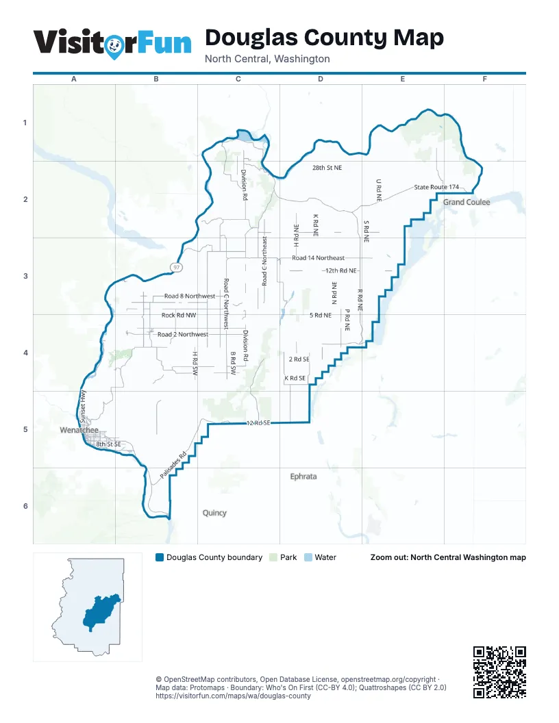
Maps inside Douglas County
1 map inside, from the street map of Douglas County down.
Street index of Douglas County
Each street on the sheet and the grid squares it crosses.
- Sunset HighwayA4, A5
- 12th Road NortheastD3, E3, D4
- State Route 28A5, B6
- Rock Island RoadA5, B5
- Grant RoadA5, B5
- United States Highway 2 EastD4, E4
- 5th Street NortheastA5
- Columbia AvenueC2, F2
- Valley Mall ParkwayA5
- East Poplar StreetB4
- West Elm StreetB4
- West Locust StreetB4
- Odabashian BridgeA5
- Coulee CorridorE4
- North Chelan AvenueB4
- South Central AvenueB4
- State Route 28 SpurA5
- State Route 285A5
- Orondo Spur RoadA4
- Senator George Sellar BridgeA5
- State Highway 155F2
- East Park StreetB4
- State Route 155F2
- Riverview Road SouthA5
- US 97 Orondo Spur RoadA4
- North Division RoadC1, C2, C3, C4
- State Route 17C2, D2, D4, E4
- State Route 174D2, E2, F2
- Badger Mountain RoadA4, B4, A5
- Road C NorthwestC2, C3, C4
- Road 14 NortheastC3, D3
- R Road NortheastD3, D4
- Road 4 SouthwestB4, C4
- State Route 173C1, C2
- Road N SouthwestB4, B5
- 14th Road NortheastC3, D3, E3
- Road O NorthwestB3, B4
- Leahy Road SouthD2, D3
- West Baseline RoadB4
- Eastmont AvenueA5
- 4th Street SoutheastA5, B5
- Titchenal Canyon RoadB4
- North Baker AvenueA5
- Battermann RoadB5
- 10th Street NortheastA5
- 14th Road NorthwestC3
- 3rd Street NortheastC1, A5
- 3rd Street SoutheastA5
- South Van Well AvenueA5
- North Kentucky AvenueA5
- 9th Street NortheastA5
- Foster Creek AvenueC2
- Main StreetC3
- Rock Island DriveB5
- Road 14 NorthwestC3
- East Railroad AvenueC3, D3
- 17th StreetC2
- 10th StreetC2
- South Chelan AvenueB4
- 9th StreetC2, A5
- Maple StreetC2
- Misawa WayA5
- Bridgeport HighwayF2
- Road 2 NorthwestB4, C4
- Palisades RoadB5, C5, B6
- Road 3 NorthwestB4, C4
- Road D NorthwestC2, C3, C4
- Road C NortheastC2, C3
- Road 6 NorthwestB3, C3
- Road 8 NorthwestB3, C3
- Whitehall Road SoutheastD4, D5
- Road 7 NorthwestB3, C3
- Road F NorthwestC3, C4
- Road 3 SouthwestA4, B4, C4
- McNeil Canyon RoadB3, C3
- Bridgeport Hill RoadC2, C3
- Central Ferry Canyon Road Northwest / Central Ferry Canyon RoadC1, C2
- Road P NorthwestB3, B4
- H Road NortheastD2, D3, D4
- Highland School Road SoutheastD4
- 18 Road NortheastC2, D2, E2
- Dyer Hill Road NorthwestC1, C2
- Smith Lake RoadE1, E2
- Road 20 NorthwestC2
- North Douglas RoadB3, B4
- 12 Road SoutheastC5
- Dyer Hill Road NortheastC1, C2
- Moses Coulee RoadC4
- H Road SouthwestB4
- Road C SouthwestC4
- Saint Andrew's South Road NortheastD3, D4
- Northwest Cascade AvenueA5
- 8th Street SoutheastA5, B5
- Road B NortheastC3
- Coulee Meadows RoadC4, C5
- 15 Road NorthwestC3
- Mansfield Road SouthC3
- F Road NorthwestC3
- South Division RoadC4
- North Jameson Lake RoadD3
- 8th Street NortheastA5
- Crane Orchard Road NorthwestC1
- Moses Coulee Road SoutheastC5
- F Road NortheastD3
- 24 Road NorthwestC5, D5
- Airport WayC3, D3, B4, A5
- L Road SoutheastD4
- South Union AvenueA5
- South Nile AvenueA5
- Fancher Heights BoulevardA5
- 10th Street SoutheastA5
- Northwest Empire AvenueA5
- Crescent Bar RoadB6
- 11th Street NortheastA5
- Highline DriveA5
- Fancher Field RoadA5
- South Kentucky AvenueA5
- 19th Street NortheastA5
- North Nile AvenueA5
- North Lyle AvenueA5
- Sun Cove RoadB3
- Saunders AvenueB5
- South Iowa AvenueA5
- Road N.5 NorthwestB3
- North Grover AvenueA5
- Wittig Road NortheastC3, D3
- 15th Street NortheastA5
- Valley View BoulevardA5
- 13th Street NortheastA5
- North Monroe StreetB4
- 23rd Street NortheastA5
- North Stark AvenueA5
- Riverview DriveA5
- South Mansfield BoulevardC3
- Pace DriveA5
- 35th Street NorthwestA5
- East Locust StreetB4
- E-NW RoadD5
- Beach DriveB3
- 21st Street NortheastA5
- North Georgia AvenueA5
- 27th Street NortheastA5
- Road 18 NortheastC2
- Pangborn DriveA5
- Simon StreetA5
- 27th Street NorthwestA5
- West Railroad AvenueC3
- Sagebrush Flats RoadC5
- Road 24 NorthwestC2
- North Hanford AvenueA5
- 19th Street NorthwestA5
- North Macaw AvenueA5
- Francher Field RoadA5
- Delaware AvenueB5
- French AvenueA5
- 38th Street NorthwestA5
- Cascade Avenue NorthwestA5
- Mathieson Road NortheastC3
- Crescent Bar Road NorthwestB6
- Road 15 NortheastC3, D3
- Road L NortheastD1, D2, D3
- N Road NortheastD2, D3, D4
- Strahl Canyon RoadE1, E2
- M Road NortheastD1, D2, D3, D4
- P Road NortheastD2, D3, D4
- Road I NortheastD2, D3
- S Road NortheastE2, E3, E4
- K Road NortheastD2, D3, D4
- Road B NorthwestC3, C4
- Hawks Cliff Road NortheastD3, E3
- Road A NortheastC2, C3, C4
- Road A NorthwestC2, C3, C4
- Road E NortheastC2, C3, C4
- J Road NortheastD2, D3, D4
- Road 4 NorthwestB4, C4
- Road I NorthwestB3, B4
- Road G NorthwestC3, C4
- Road 1 SouthwestB4, C4
- 19 Road NortheastC2, D2
- 13th Road NortheastC3, D3, E3
- 5 Road NortheastD4, E4
- V Road NortheastE1, E2, E3
- U Road NortheastE2, E3
- Rock Road NorthwestB4, C4
- Del Rio RoadD2, E2
- Road E SoutheastC4, C5
- Road D NortheastC2, C3, C4
- Road 2 SouthwestB4, C4
- Road 25 NorthwestC2
- Box Canyon RoadD1, D2, B3
- Road S NortheastD2, E2
- Road G NortheastD2, D3
- Road 17 NortheastC3
- 17 Road NortheastD3, E3
- Chelan Hills Acres RoadB3
- Road H NorthwestB3, B4
- 4 Road NortheastD4
- Road E SouthwestC4, C5
- 20 Road NortheastC2, D2, E2
- Pendell RoadF1, F2
- Rock Island Grade RoadB5
- 2 Road SoutheastC4, D4
- Road 5 NorthwestC3, B4, C4
- Leahy Cutoff Road NortheastD2
- 26 Road NortheastC2, D2, E2
- Road E NorthwestC2, C3, C4
- Road Q NorthwestB3, B4
- Woods Road NortheastD3, D4
- T Road NortheastE2, E3
- Pearl Hill Road NortheastC2, D2
- 26 Rex Road NortheastE2
- Road J SouthwestB4
- 28th Street NortheastD2
- O Road NortheastD2, D3, E3, D4
- China Creek RoadE1
- H Road SoutheastD4, D5
- Road 16 NortheastD3
- Barker Canyon Road NortheastE2
- Q Road NortheastD1, D2, D3, D4
- Jameson Lake Road NortheastC4, D4
- 7 Road NorthwestC3
- Road 12 NortheastC3, D3
- Road 5 NortheastC4
- Road 9 NorthwestB3, C3
- Road 16 NorthwestC3
- Road J NorthwestB3, B4
- B Road SouthwestC4
- Road 10 NorthwestB3, C3
- 1st Road NorthwestB4, C4
- Slack Canyon RoadB4, B5, C5
- Baseline RoadD4
- A Road SouthwestC4
- South Douglas Creek RoadB4
- Highland Orchard Road NortheastD1, D2
- Y Northeast RoadE1, E2
- W Road NortheastE1, E2, E3
- Brays Landing RoadA3, B3
- K Road SoutheastD4
- Road 1 NorthwestB4
- G Road SoutheastD4
- Road 10 NortheastC3
- Rogers Road NortheastE2
- 25 Road NortheastC2, D2
- Black Rock RoadA4, B4
- Road M NorthwestB3, B4
- Road 5 SouthwestB4, C4
- 1st Road NortheastC4, D4
- B Road NortheastE1, E2, C3
- Chalk Hills Road NortheastD2
- Stuhlmiller RoadB6
- Road K NorthwestB3
- Columbia Siding RoadB6
- 7 Road NortheastC3, D3
- Buckeye Road NortheastD3
- 8 Road NortheastD3, E3
- 9 Road NortheastD3, E3
- Road L Cutoff NorthwestB3, B4
- Browns Canyon RoadB3
- Old Todora RoadC4, C5
- Deer Creek DriveB4
- Big Bend RoadE1, F1
- Road S SouthwestB4, B5
- Doneen Rainey RoadA4, A5
- Leahy Road NorthD2
- 21 Road NortheastD2
- X Road NortheastE1, E2
- A Road NorthwestC2, C4
- Road I SouthwestB4
- Mountain Spring RoadB3, C3
- Garred RoadD4
- Road 8 SoutheastC5
- Crane Orchard RoadC1
- 32 3/4 NortheastE1
- Saint Andrew's North Road NortheastD3
- Sheehan RoadB4, B5
- Rd 25 NE (Coleman Hill Rd)D2
- North Mansfield RoadC2
- Road U SouthwestA4, A5
- Road F NortheastD3
- F Road SouthwestC4
- Twin Springs RoadE1
- Alstown Cutoff RoadB4, C4
- 6 Road NortheastD3
- Spring Canyon RoadC3
- Saint Andrew's West Road NortheastD3
- 13th Road NorthwestC3
- Blue Grade RoadA5
- 16 Road NortheastD3
- Road 9 SouthwestA5, B5
- Barry Rex RoadF2
- Wild Turkey RoadB4
- Tumbleweed WayC5
- Ruud Canyon Road SouthwestB4
- West Coyote TrailC5
- Hummingbird RoadB4
- Melvin RoadA4, B4
- Sand Hill RoadC2, D2
- 2nd Street SoutheastA5
- Ferrell Road SouthwestB4
- Branding Iron DriveC5
Places on the map
- Alexander Lake
- Banks Lake Wildlife Area
- Barker Canyon Lake
- Beebe Bridge Park
- Beebe Bridge Park Campground
- Bennett Lake
- Big Bend Wildlife Area
- Black Lake
- Blue Heron Lake
- Boulder Park and McNeil Canyon Haystack Rocks
- Brandts Landing
- Bridgeport
- Bridgeport Bar Wildlife Area
- Bridgeport Wildlife Area
- Buck Lake
- Central Ferry Canyon Wildlife Area
- Chester Butte Wildlife Area
- Cornehl Lake
- Daroga State Park
- Daroga State Park Campground
- Desert Canyon Golf Resort
- Dormaier Wildlife Area
- Douglas and Duffy Creek
- East Wenatchee
- Grimes Lake
- Hammond Lake
- Haynes Lake
- Jameson Lake
- Kirby Billingsley Hydro Park
- Klinkhammer Lakes
- Lake Pateros
- Lincoln Rock State Park
- Mansfield
- Moses Coulee Preserve
- Rock Island
- Rock Island Golf Course
- Rock Island Pond
- Sagebrush Flats Wildlife Area
- Waterville
- West Foster Creek Wildlife Area
Next to Douglas County
- Ephrata
- Grand Coulee
- Quincy
- Wenatchee map
© OpenStreetMap contributors, Open Database License, openstreetmap.org/copyright · Map data: Protomaps · Boundary: Who's On First (CC-BY 4.0); Quattroshapes (CC BY 2.0)















