

Washington map
Wenatchee map
About 35,401 people live here (Census Bureau, 2024 estimate). The sheet's index lists 300 streets; Methow Street, North Wenatchee Avenue and South Mission Street cross the most grid squares. Things to do inside the boundary: Cascade Loop and Wenatchee Outdoors.
Open the map (PDF, US Letter)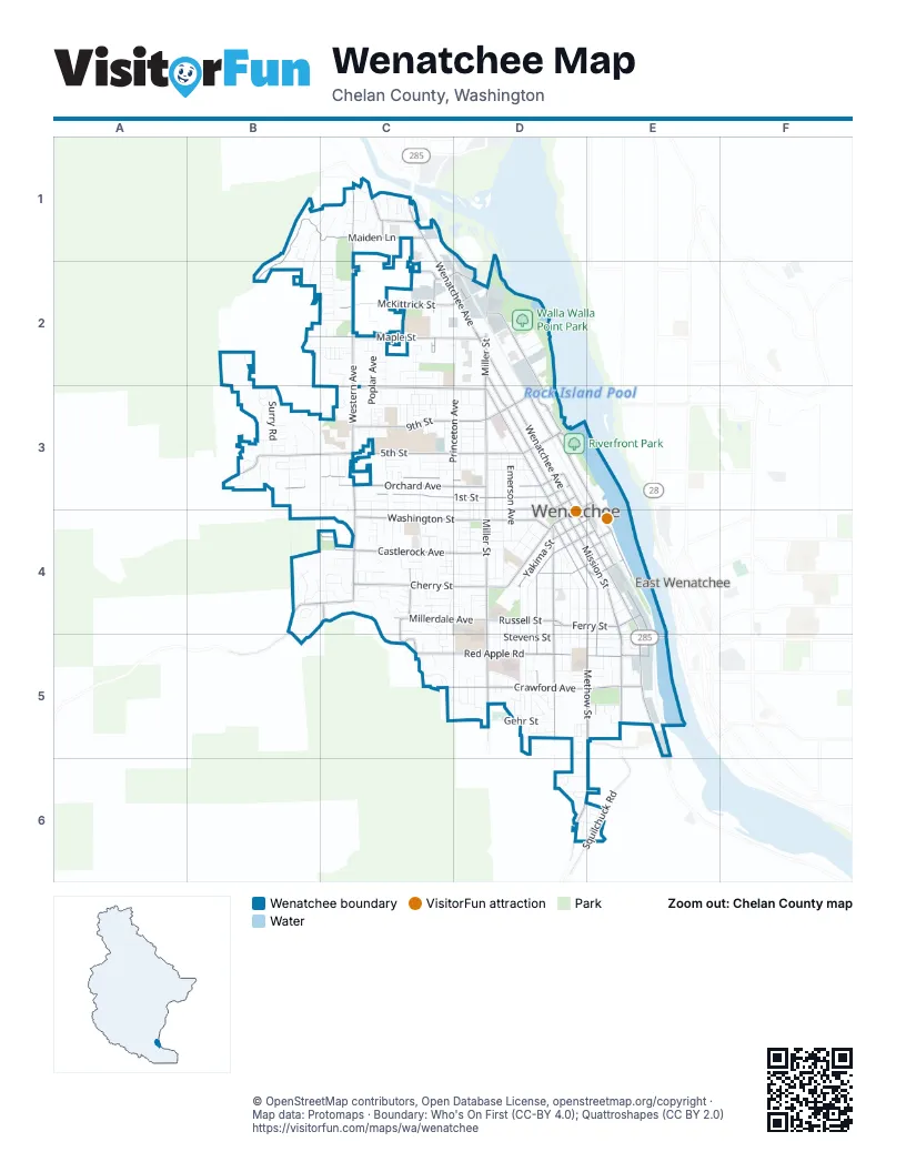
Street index of Wenatchee
Each street on the sheet and the grid squares it crosses.
- North Wenatchee AvenueC1, C2, D2, D3
- South Mission StreetD3, D4, E4, E5
- South Wenatchee AvenueD3, D4, E4, E5
- North Miller StreetD2, D3
- South Chelan AvenueD3, D4, E4, E5
- North Mission StreetD2, D3
- North Chelan AvenueD3
- Senator George Sellar BridgeE5
- State Route 285E4, E5
- North Western AvenueC1, C2, C3, C4
- 5th StreetB3, C3, D3
- South Miller StreetD3, D4, D5
- Maiden LaneB1, C1, B2
- Crawford AvenueC5, D5, E5
- Cherry StreetC4, D4
- South Columbia StreetD3, D4, E4, E5
- Orondo AvenueE3, D4
- Ferry StreetD4, E4
- Riverside DriveD3
- South Western AvenueC4
- South Worthen StreetE3, E4
- North Worthen StreetD3, E3
- Marr StreetE5
- Russell StreetD4
- Squilchuck RoadE6
- Thurston StreetE4
- Methow StreetD4, E4, E5, D6, E6
- Okanogan AvenueD4, D5
- Maple StreetB2, C2, D2
- Washington StreetC4, D4
- 1st StreetC3, D3
- 9th StreetC3, D3
- Castlerock AvenueC4, D4
- Kittitas StreetD4, E4, D5
- Orchard AvenueB3, C3, D3
- Red Apple RoadC5, D5
- Springwater AvenueC3, D3
- McKittrick StreetC2, D2
- 2nd StreetC3, D3
- Yakima StreetD4, E4
- Walla Walla AvenueD2, D3
- Millerdale AvenueC4, D4
- Skyline DriveC4, C5
- Spokane StreetD4, E4
- Palouse StreetD3
- Number 2 Canyon RoadB4, C4
- Horse Lake RoadC1
- Appleland DriveC4, C5
- Lambert StreetC4
- Piere StreetD3
- Walnut StreetC2
- Number 1 Canyon RoadB3
- North Columbia StreetD2, D3
- Pine StreetC2
- East Hawley StreetD2
- Chehalis StreetE4
- Dawn TerraceC1
- East 9th StreetD3
- Terminal AvenueE5
- Hawley StreetC2, D2
- Pearl Street SouthD4
- Princeton AvenueD2, C3, D3, D4
- Fuller StreetD4, D5
- Stevens StreetD5, E5
- Cashmere StreetE4, E5
- Madison StreetC3, D3
- Westwood AvenueC3, D3
- 3rd StreetC3, D3
- Poplar AvenueC2, C3, C4
- Cascade StreetD4, D5
- Jefferson StreetC3, C4, D4
- Pershing StreetC2, C3, C4
- North Emerson AvenueD3
- 4th StreetC3, D3
- Idaho StreetD4
- South Wilson StreetD4
- Monroe StreetD4, D5
- Heatherwood DriveC4
- Walker AvenueD4, D5
- Malaga AvenueD4, D5
- South Hills DriveC5
- North Elliott AvenueC3, C4
- Peachy StreetD4, E4
- South Franklin AvenueD3, D4
- Central AvenueC2, D2
- Highland DriveD4, D5
- Woodward DriveC2, C3
- Surry RoadB3
- South Elliott AvenueC4
- Saddlerock DriveD4, D5
- Heritage DriveC2
- Brown StreetC2, C3
- Monitor AvenueE4, E5
- Broadway PlaceB1, C1, B2
- Ramona AvenueD3
- Westview DriveB2, B3
- North Franklin AvenueD3
- King StreetD3, D4
- North Garfield AvenueD3
- Sunset AvenueD3
- Gehr StreetD5
- Douglas StreetD3, D4
- Angela StreetC2
- Meadow Ridge DriveC3
- Jennings StreetB3
- 7th StreetC3, D3
- North Delaware AvenueD3
- Columbine StreetC4, D4
- Center Court DriveB4
- Wedgewood AvenueD4, D5
- Meadows DriveB3
- Ridgeview Loop DriveD5, E5
- Brandi LaneC4
- Sunrise CircleC1
- Linville DriveB4, C4
- Alaska StreetD4
- Crescent StreetE4, E5
- Rosewood AvenueD4, D5
- Lewis StreetD4, E4
- Vista PlaceC4, C5
- BroadviewB1, B2
- Lincoln StreetD5, E5
- Seattle AvenueC2
- Lincoln Park CircleD5, E5
- Dana StreetC3, C4
- Castle Heights DriveB4
- Kayla WayD5
- Lasso DriveE6
- Dakota StreetC4, D4
- Montana StreetC4, D4
- Citation LoopD6, E6
- Hawthorne StreetD4
- Lowe StreetC4
- 8th StreetC3, D3
- Canyon Creek DriveB3
- Seneca StreetD5
- Pickens StreetC4
- Grenz StreetC3
- Ormiston StreetD5
- Utah StreetC4, D4
- Poe StreetD5
- Gellatly StreetC4
- Lynn StreetD5, E5
- Foothills LaneC2, C3
- Glenwood AvenueD4, D5
- Linwood AvenueD4, D5
- North Wilson StreetD3, D4
- Parkway AvenueE5
- Whitebirch PlaceC4
- Chrisand LaneD6, E6
- Morris StreetC3
- Pearl StreetD4
- Pear LaneC3
- Stella AvenueC2
- South Delaware AvenueD3, D4
- Tacoma StreetC2
- Hainsworth StreetD5
- Ringold StreetC3
- Amherst AvenueC2, C3
- Mulberry LaneC2
- Hideaway PlaceB2, C2
- South Emerson AvenueD3, D4
- Welch AvenueC2
- Saddlehorn LaneE6
- Marie AvenueC3
- Stephanie BrookeB3
- Rainier StreetC4
- Saddle Rock LoopD6, E6
- Trisha WayD5
- Twin Peaks DriveC2
- Westwick RoadB2, B3
- Pennsylvania AvenueD3
- Pioneer DriveD4
- Sienna RoadC3
- Lion PlaceC2
- Virginia WayD5
- West Honeysett RoadC1
- Bryan StreetD4
- Duncan RoadC1
- Kings CourtB4
- Pershing CircleC3
- Clark DriveC2
- Ashley BrookeB3
- Windsor CourtC4
- Cumbo CourtC4
- Honeysett RoadC1
- Leavenworth PlaceC2
- Pensione PlaceC2
- Broadcrest CourtB1
- Westmorland DriveB3
- Stewart StreetC4
- Dorner PlaceC4
- Oak StreetD5
- Canal BoulevardC3, C4, C5
- Willowbrook DriveD5
- Canyon PlaceB3
- Somerset DriveC4
- Oregon StreetD4
- Rex RoadD5
- Canyon Crest DriveC4
- Splett StreetC5, D5
- Marilyn AvenueC3
- Shady LaneB3
- Fairview AvenueC3
- Avenida WayC1
- Grandview AvenueC4
- Aspen Creek LaneC3
- Vasser AvenueC3
- Bridge StreetE4
- Kenaston DriveC4
- College StreetC3
- Melissa WayD5
- Broad AvenueE5
- Broadway NorthC1
- Grandview LoopC4
- Saint Joseph PlaceC4
- Dogwood LaneC4
- North Buchanan AvenueD3
- North Cleveland AvenueD3
- Cedar Wood LaneB3
- Westmoreland DriveB3
- Brookside WayD5
- Martin PlaceC4
- South Cleveland AvenueD3, D4
- Holbrook StreetC3
- Summercreek PlaceC4
- River Park AvenueD2
- Songbird LaneD5
- Redwood StreetC4
- North RoadC1
- Story LaneC2
- Benton StreetE4
- Saddlehorn AvenueD6, E6
- Gellatly AvenueC4, C5
- Jolen DriveD6
- Appleridge StreetC4
- Charles StreetD4
- Craig AvenueD5
- John StreetC4
- Roosevelt AvenueD4
- Danawood DriveC3
- Johnson StreetC4
- Lars LaneB3
- Patsue PlaceC5
- South Garfield StreetD3, D4
- Columbia View CircleC1
- Quail Hollow LaneC1
- Willow PlaceD5
- Snohomish StreetE5
- Locust StreetC1
- Willis StreetC3
- Whitman WayD3
- Schons PlaceD5, E5
- Sunburst StreetC3, C4
- Woodhaven PlaceC4
- Coolidge DriveD4
- Academy StreetC3
- Dillon StreetC4
- South Cove AvenueC4
- Castleview PlaceC4
- Furney StreetD3, D4
- Schafer StreetC4
- Tanda LaneC1
- Harrison StreetD3, D4
- Marian AvenueC4
- Meeks StreetC3
- Park StreetE4
- Plum StreetD4
- Yarrow RoadB3
- Mills AvenueD3
- Quail RunC4
- Sage Grouse RoadB3
- West Park StreetD5
- Gossman LaneC5, D5
- Island View StreetD3
- Tyler StreetD4
- Harvard AvenueD3
- West Knoll AvenueB3
- Yale AvenueD3
- Lindy StreetD4
- Pearview CircleD5
- Red Hawk Canyon DriveB3
- Apollo PlaceC4
- Riter StreetB3
- Broadview NorthB1, C1
- Edgecliff RoadC1
- Enchantment PlaceC2
- Fairhaven AvenueC3
- Marjo StreetE5
- Wellington PlaceC4
- Kriewald CourtC4
- Lester RoadB3
- Seneca PlaceD5
- Woodridge StreetB3
- Roper LaneE6
- South Pearl StreetD4
- Ione StreetB3
- Michael PlaceC3
- WesthavenC1
- Benoy AvenueB2, C2
Things to do on the Wenatchee map
Places on the map
- 212 5th Street
- Cascade Christian Academy
- Central Washington Hospital
- Colonial Vista Care Center
- First Presbyterian Church
- Foothills Middle School
- Hale Dog Park
- Hale Park
- John Newbery Elementary
- Lewis and Clark Park
- Lincoln Elementary School
- Lincoln Park
- Linden Tree Park
- Lowe's
- Memorial Park
- North Avenue Plaza
- Orchard Middle School
- Parkside Manor Nursing Home
- Pioneer Middle School
- Pioneer Park
- Pybus Public Market
- Riverfront Park
- Rotary Park
- Sage Hills Church
- Skookum Plaza
- The UPS Store
- Town Toyota Center
- Triangle Park
- Valley Academy of Learning
- Valley North Center
- Walla Walla Point Park
- Walmart Supercenter
- Washington Elementary School
- Wenatchee Cemetery
- Wenatchee City Hall
- Wenatchee Columbia Station
- Wenatchee High School
- Wenatchee Valley Medical Center
- Wenatchee Youth Baseball Inc.
- WSU Wenatchee TFREC
Next to Wenatchee
© OpenStreetMap contributors, Open Database License, openstreetmap.org/copyright · Map data: Protomaps · Boundary: Who's On First (CC-BY 4.0); Quattroshapes (CC BY 2.0)















