

Washington map
East Wenatchee map
About 14,330 people live here (Census Bureau, 2024 estimate). The sheet's index lists 183 streets; Sunset Highway, North Baker Avenue and Eastmont Avenue cross the most grid squares. Also on it: Costco, Wenatchee Valley Mall and East Wenatchee Library.
Open the map (PDF, US Letter)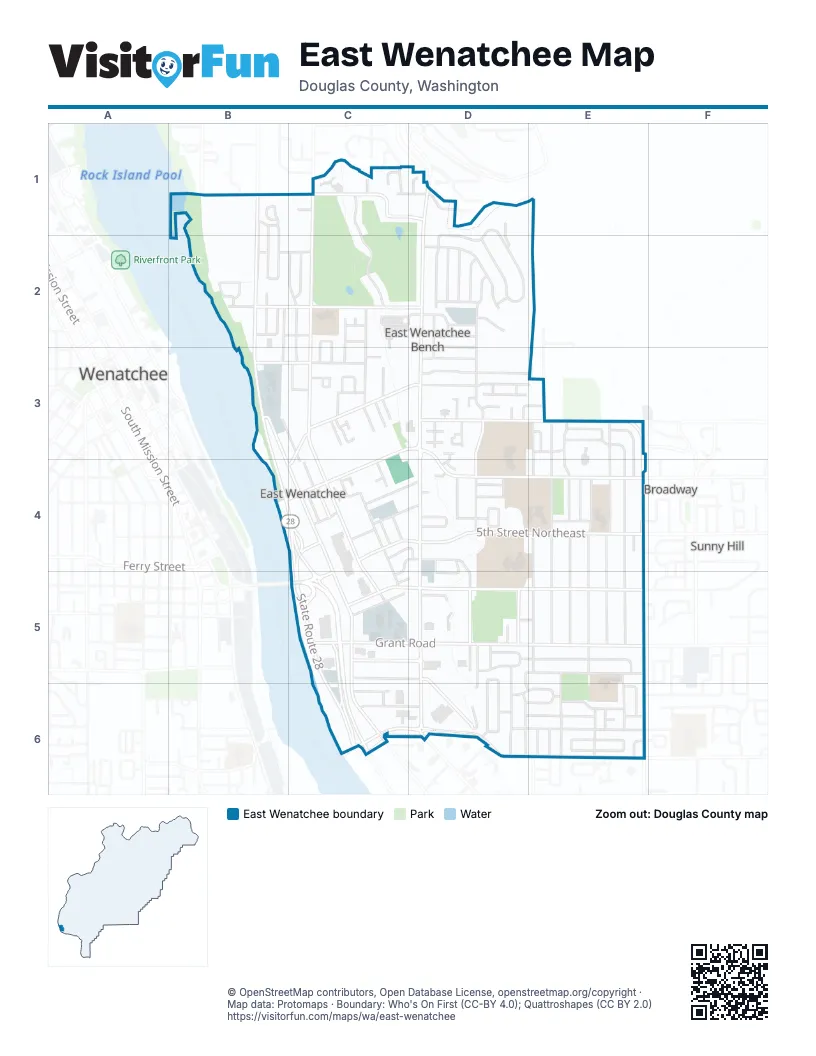
Street index of East Wenatchee
Each street on the sheet and the grid squares it crosses.
- 18th Street NortheastB1
- 19th Street NortheastB1, C1, D1
- 19th Street NorthwestB1
- North Anne AvenueB1, B2
- North Aurora AvenueB1, B2
- Sunset HighwayB1, B2, B3, B4, C4, C5
- Country Club DriveC1, C2
- Dorado CourtC1
- Ironwood PlaceC1
- King PlaceC1, D1
- North Baker AvenueC1, C2, C3, C4, C5
- North Devon AvenueC1, C2, C3, C4
- Stoneridge DriveC1
- Briarwood DriveD1, D2
- Briarwood PlaceD1, E1, D2
- Eastmont AvenueD1, D2, D3, D4, D5
- Peach Haven CourtD1
- 14th Street NortheastB2, C2, D2
- 15th Street NortheastB2, C2, D2
- 15th Street NorthwestB2
- 16th Court NorthwestB2
- 16th Street NortheastB2
- 17th Street NortheastB2, C2
- North Arbor TerraceB2, B3
- Northwest Avon CourtB2
- Northwest Webster Park TerraceB2
- Capri DriveC2
- Clements CircleC2, C3
- North Ashland AvenueC2, C3
- North Astor CourtC2
- Terrace Court NortheastC2, C3
- Terrace DriveC2
- Briarwood TerraceD2
- Clarissa LaneD2
- France Street NortheastD2
- Gormley StreetD2, D3
- Hannah WayD2
- Harrington LaneD2
- Hillside DriveD2
- Holly LaneD2
- Huntwood LaneD2
- North Fairmont AvenueD2, D3
- North Ford PlaceD2
- North Grover AvenueD2, D3, D4
- Welch LaneD2
- 13th Street NortheastB3, C3, D3
- North Alvin CourtB3, C3, C4
- Valley Mall ParkwayB3, B4, C4, C5
- 11th Street NortheastC3, D3, E3, B4, C4
- 12th Place NortheastC3
- 12th Street NortheastC3, D3
- 9th Street NortheastC3, D3, E3, C4
- Barton SquareC3
- Cedar CourtC3
- Cedar LaneC3
- Cherry CircleC3
- Corum CircleC3
- Greenbriar LaneC3
- North Colorado AvenueC3, C4, C5
- North Dennis CourtC3
- North Dolfay LaneC3
- North Huber CourtC3
- 10th Street NortheastD3, E3
- Amy CourtD3
- Cindy CourtD3
- Fairview PlaceD3
- Fawn CircleD3
- Gilbert CourtD3
- Goldenview DriveD3, D4
- Goldenview PlaceD3
- Harrison CourtD3, E3
- Jackie LaneD3
- Linda CourtD3
- Manzanal Street NortheastD3
- Marcie CourtD3
- Misawa WayD3, D4
- North Gale AvenueD3
- North Guerin LaneD3
- North Hale LaneD3
- Sheri CourtD3
- Bel Air DriveE3
- Easthills TerraceE3
- Jackson PlaceE3
- Kenroy TerraceE3, E4
- North Iowa AvenueE3, E4, E5
- North Jackson AvenueE3
- North Jackson PlaceE3
- North James AvenueE3, E4, E5
- North Jennifer LaneE3, E4
- North Kansas AvenueE3, E4, E5
- North Keller AvenueE3, E4, E5
- North Kentucky AvenueE3, E4, E5
- 9th StreetB4, C4
- 4th Street NortheastC4, D4, C5
- 5th Street NortheastC4, D4, E4, C5
- 6th Street NortheastC4, D4
- 7th Street NortheastC4, D4
- 8th Street NortheastC4, D4, E4
- Colby CourtC4
- French AvenueC4
- Hamilton AvenueC4
- Johnson Place NortheastC4, D4
- North Darwood AvenueC4
- North Dayton AvenueC4
- Standerfer StreetC4
- State Route 28C4, C5, C6
- 8th Court NortheastD4
- Degage StreetD4, D5
- Ella Street NortheastD4
- Etta Street NortheastD4
- Fairway DriveD4
- Garden CourtD4
- Garden PlazaD4
- Genesis LaneD4
- North Gale PlaceD4
- North Georgia AvenueD4, D5
- North Grover PlaceD4
- North Hale AvenueD4
- Rolfs CourtD4
- Rolfs PlaceD4
- Smile DriveD4
- 6th Place NortheastE4
- Fuller StreetE4
- Lacy PlaceE4
- North Jerome LaneE4
- North Jonathan AvenueE4
- North Joseph AvenueE4, E5
- North June AvenueE4, E5
- North Kent TerraceE4
- 1st Street SoutheastC5, D5, E5
- 2nd Street NortheastC5, D5
- 3rd Street NortheastC5, D5, E5
- Colorado Park PlaceC5, D5
- Grant RoadC5, D5, E5
- Riverview DriveC5, C6
- Rock Island RoadC5, C6
- Senator George Sellar BridgeC5
- Simon StreetC5, D5
- State Route 28 SpurC5
- State Route 285C5
- WendysC5
- 1st Place SoutheastD5
- 1st Street NortheastD5, E5
- Eastridge DriveD5, D6
- Highline DriveD5, D6
- North Green PlaceD5
- North Hanford AvenueD5
- Pace DriveD5, D6
- Ridgemont DriveD5, D6
- South Georgia AvenueD5, D6
- South Gilmore PlaceD5
- South Grover AvenueD5
- South Houston AvenueD5, D6
- South Iowa AvenueD5, E5, D6, E6
- Tedford Street SoutheastD5, E5
- South Jarvis AvenueE5, E6
- South June AvenueE5
- South Keller AvenueE5, E6
- South Kentucky AvenueE5, E6
- 2nd Street SoutheastC6, D6, E6
- 3rd Street SoutheastC6, D6, E6
- McGee Street SoutheastC6
- Riverview Road SouthC6
- South Dean AvenueC6
- 2nd Place SoutheastD6
- East Ridge DriveD6
- Edwards PlaceD6
- Elva Way SoutheastD6
- Parkroy Place SoutheastD6, E6
- Southeast Dale StreetD6, E6
- 4th Street SoutheastE6
- Boulder LoopE6
- Copper LoopE6
- Darald PlaceE6
- Soden Street SoutheastE6
- South Jackson PlaceE6
- South James AvenueE6
- South Kansas AvenueE6
- South Kansas LoopE6
- South Karry AvenueE6
- South Kent CourtE6
- South Kent PlaceE6
- South Kent PlazaE6
Places on the map
- 19th Street Trailhead
- 7-Eleven
- Abby's
- Ag Supply Company
- AutoZone
- Ay Caramba
- Bethel Baptist Church
- Bi-Mart
- Bob's Burgers and Brew
- Burger King
- Buzz Inn Steakhouse & Casino
- Canyon View Group Home
- Cascade Unitarian Universalist Church
- Cashmere Valley Bank
- Cedars Inn
- Chapel of the Valley
- Chase
- Cherryhill Park
- Coastal Farm & Ranch
- Costco
- CVCH East Wenatchee Medical
- Dairy Queen
- Douglas County Fire District 2 Station 1
- Douglas County Justice Center
- East Wenatchee City Hall
- East Wenatchee Clinic
- East Wenatchee Library
- Eastmont Baseball/Softball Batting Cages
- Eastmont Community Park
- Eastmont High School
- Eastmont Junior High School
- Grant Elementary School
- Highline Plaza
- Kenroy Elementary School
- Lee Elementary School
- Sterling Junior High School
- Tedford Park
- The UPS Store
- Wenatchee Golf and Country Club
- Wenatchee Valley Mall
Next to East Wenatchee
- Broadway
- Sunny Hill
- Wenatchee map
© OpenStreetMap contributors, Open Database License, openstreetmap.org/copyright · Map data: Protomaps · Boundary: Who's On First (CC-BY 4.0); Quattroshapes (CC BY 2.0)















