

Washington map
Enumclaw map
About 13,173 people live here (Census Bureau, 2024 estimate). The sheet's index lists 261 streets; Enumclaw Buckley Road, 244th Avenue Southeast and Florence Street cross the most grid squares. Things to do inside the boundary: Seattle Scottish Highland Games.
Open the map (PDF, US Letter)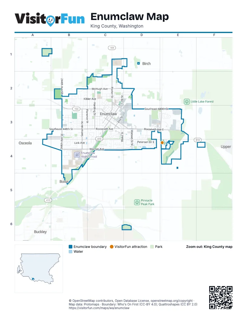
Street index of Enumclaw
Each street on the sheet and the grid squares it crosses.
- Southeast 416th StreetA1
- 244th Avenue SoutheastB2, B3, B4
- Carbon Ridge StreetB2
- Clovercrest StreetB2, B3
- Florence StreetB2, B3, C3
- Gossard PlaceB2
- Gossard StreetB2, B3
- Hawk CourtB2
- Highpoint StreetB2, B3
- Hunter CourtB2
- Kibler AvenueB2, C2
- Lois LaneB2, B3
- Maplewood LaneB2
- McHugh AvenueB2, C2
- McKinley StreetB2, B3, B4
- Olympic PlaceB2
- Perry CourtB2
- Silver Springs AvenueB2
- Southeast 433rd StreetB2
- Southeast 436th StreetB2
- Southeast 437th PlaceB2
- Wyrick CourtB2
- 257th Place SoutheastC2
- 260th Avenue SoutheastC2
- 268th Avenue SoutheastC2, C4
- Adams AvenueC2, C3
- Bailey StreetC2
- Battersby AvenueC2, C3, D3
- Chinook AvenueC2, D2
- Cinkovich StreetC2
- Cole StreetC2, C3
- Davis AvenueC2
- Division StreetC2, C3
- Fell StreetC2, C3
- Fredricksen StreetC2
- Garfield StreetC2, C3
- Hansen StreetC2
- Hanson StreetC2
- Harding StreetC2, C3
- Hillcrest AvenueC2
- James StreetC2
- Jensen StreetC2, C3
- Lafromboise StreetC2, C3
- Loraine StreetC2, C3
- Lowell AvenueC2
- Lowell PlaceC2
- Malatesta CourtC2
- Marshall AvenueC2, C3
- McHugh PlaceC2
- Merritt AvenueC2
- Michael AvenueC2, D2
- Park StreetC2, C3
- Pioneer StreetC2, C3
- Porter StreetC2, C3
- Shanon LaneC2
- Sorenson AvenueC2
- Southeast 427th StreetC2
- Southeast 428th StreetC2
- Southeast 429th StreetC2
- Southeast 432nd StreetC2
- Washington AvenueC2, C3
- Weber StreetC2
- Wilson AvenueC2
- 248th Avenue SoutheastB3
- Artesia StreetB3
- Berilla DriveB3
- Blanchat CourtB3, B4
- Boyle StreetB3
- Cascade AvenueB3
- Christianson AvenueB3
- Edel AvenueB3
- Edel CourtB3
- Edith AvenueB3, C3
- Elmont AvenueB3, C3
- Farrelly StreetB3, B4
- Fisk AvenueB3
- Gillis CourtB3, B4
- Gray LaneB3
- Green River CourtB3
- Griffin AvenueB3, C3, D3
- Hamilton PlaceB3, B4
- Initial AvenueB3, C3
- Initial PlaceB3
- Isbell CourtB3
- Lincoln AvenueB3, C3
- Lindenberger LaneB3
- Louise CourtB3
- May CourtB3
- Meadow Park AvenueB3
- Okerlund DriveB3
- Olie Ann PlaceB3
- Roosevelt AvenueB3, C3, D3
- Semanski StreetB3, B4
- Southeast 436th WayB3
- Southeast 440th StreetB3, D3, E3
- Southeast 448th StreetB3
- Sun Mountain DriveB3
- Terry LaneB3
- Victor StreetB3, B4
- Voss StreetB3
- West CourtB3
- Williams PlaceB3
- 1st StreetC3
- 2nd StreetC3, D3
- 3rd StreetC3
- A CourtC3
- B CourtC3
- Blake StreetC3, C4
- C CourtC3
- Cedar DriveC3
- Charwila LaneC3, C4
- Cottonwood DriveC3
- Dickson AvenueC3, D3
- Dogwood PlaceC3
- Enumclaw Buckley RoadC3, B4, C4, B5
- Franklin StreetC3
- Harmony LaneC3, C4
- Jefferson AvenueC3
- Johnson StreetC3, C4
- Maple DriveC3
- Marion StreetC3
- Martin WayC3
- Melody LaneC3
- Mill AvenueC3
- Monroe AvenueC3
- Montgomery AvenueC3
- Mountain Villa DriveC3
- Myrtine StreetC3
- Myrtle AvenueC3
- Natalie PlaceC3
- Neilsen AvenueC3
- Noble PlaceC3
- Paramount DriveC3
- Pine DriveC3
- Railroad StreetC3
- Rainier AvenueC3, D3
- Rainier Avenue AlleyC3, D3
- Roosevelt Avenue EastC3, D3, E3
- Scandia AvenueC3
- Scandia CourtC3
- Spruce DriveC3
- Stevenson AvenueC3
- Wells StreetC3
- Alpine PlaceD3, E3
- Barquist Lane NorthD3
- Becky Avenue EastD3
- Carrie Drive EastD3
- Cedar StreetD3
- Commerce StreetD3
- Cooper Lane NorthD3, D4
- Deusen Lane NorthD3, D4
- Dudley StreetD3
- Gamblin StreetD3
- Marcie Lane NorthD3
- Mountain Peak Street NorthD3, D4
- Smith DriveD3
- Suntop Boulevard NorthD3, D4
- Vickie Lane NorthD3
- Watson Street NorthD3, D4
- Weaver Drive EastD3
- 284th Avenue SoutheastE3, E4
- 286th Avenue SoutheastE3
- 288th Avenue SoutheastE3
- Alpine CourtE3
- Anadoll AvenueE3
- Cedar CourtE3
- Crystal Mountain DriveE3
- Estero AvenueE3
- Farman Street NorthE3
- Glacier StreetE3
- Kimberly AvenueE3
- Liberty Ridge AvenueE3
- Mountain View DriveE3
- Orangewood StreetE3
- Par LaneE3
- Paradise AvenueE3
- Rincon AvenueE3
- Southeast 449th StreetE3
- Southeast 451st StreetE3
- Sunset AvenueE3
- Sunset CourtE3
- Timber StreetE3
- Treeline CourtE3
- Ventura AvenueE3
- Ventura CourtE3
- 252nd Avenue SoutheastB4
- Almadon StreetB4
- Burger PlaceB4
- Chelsea LaneB4
- Garland PlaceB4
- Hazel PlaceB4
- Justice PlaceB4
- Larsen AvenueB4
- Laukala PlaceB4
- Leo's PlaceB4
- Link AvenueB4
- McDougall AvenueB4
- McKean CourtB4
- Moore AvenueB4
- Phillips AvenueB4
- Randall PlaceB4
- School District RoadB4
- Semanski Street SouthB4
- Spring PlaceB4
- Summer PlaceB4
- Ward CourtB4
- Warner AvenueB4, C4, D4
- Wetherbee LaneB4
- Winter PlaceB4
- Wynalda DriveB4
- Aspen LaneC4
- Bangert PlaceC4
- Bathke AvenueC4
- Baysinger PlaceC4
- Berninger StreetC4
- Birch DriveC4
- Carley PlaceC4
- D CourtC4
- Douglas Fir DriveC4
- Grand Fir DriveC4
- Jester LaneC4
- Noble Fir CircleC4
- Noel StreetC4
- Olsen PlaceC4
- Petschauer PlaceC4
- Pine Cone AvenueC4
- Redwood StreetC4
- Schmid StreetC4
- Thompson DriveC4
- Wallace AvenueC4
- Warwick StreetC4
- Willow DriveC4
- 276th Avenue SoutheastD4
- Asmundson Lane NorthD4
- Baur LaneD4
- Bondgard AvenueD4
- Bondgard Avenue EastD4
- Bruhn Lane NorthD4
- Ericksen Lane NorthD4
- Franks Lane NorthD4
- Grennan Lane NorthD4
- Hogan DriveD4
- Holdener Lane NorthD4
- Iris Lane NorthD4
- Jasmine Lane NorthD4
- Jewell StreetD4
- Love DriveD4
- Petersen Drive EastD4
- Riggs Drive EastD4
- Riley Court EastD4
- Riley Drive EastD4
- Sigrist Drive EastD4
- Southeast 456th StreetD4
- Warner Avenue EastD4
- Cattle DriveE4
- Main StreetE4
- Northern TrailE4
- Rodeo DriveE4
- Southeast 452nd StreetE4
- Southern TrailE4
- The Cut-OffE4
Things to do on the Enumclaw map
Places on the map
- A Company
- Allen's Furniture
- Anderson Riverview Park
- April's Pet Salon
- Arts Alive!
- AutoZone
- Awesome Massage
- Birth To Five Center
- Boise Creek Park
- Bordeaux Wine Bar
- Brown Bear Car Wash
- Byron Kibler Elementary School
- C.C.'s Collectibles on Cole
- Calvary Presbyterian Church
- Cascade Automotive
- Chalet Theatre
- Chase
- Clem's Enumclaw Powersports
- Cobber's Pet Pantry
- Columbia Bank
- Commencement Bank
- Creative Minds Learning Center
- Crossfit Devotion
- Enumclaw Airport
- Enumclaw City Hall
- Enumclaw Golf Course
- Enumclaw High School
- Enumclaw Middle School
- Enumclaw Recycling & Transfer Station
- Fugate Ford
- Mahler Park
- Mail Express
- Southwood Elementary School
- Southwood Soccer Fields
- St. Elizabeth Hospital
- Sunrise Elementary School
- Thunder Mountain Middle School
- United States Post Office Enumclaw
Next to Enumclaw
- Birch
- Boise
- Buckley
- Glacier Vista
- Osceola
- Upper Mill
© OpenStreetMap contributors, Open Database License, openstreetmap.org/copyright · Map data: Protomaps · Boundary: Who's On First (CC-BY 4.0); Quattroshapes (CC BY 2.0)















