

Washington map
Grant County map
About 104,717 people live here (Census Bureau, 2024 estimate). The sheet's index lists 300 streets; Main Street, North Frontage Road and Coulee Corridor cross the most grid squares. Things to do inside the boundary: Moses Lake and The Gorge Amphitheatre.
Open the map (PDF, US Letter)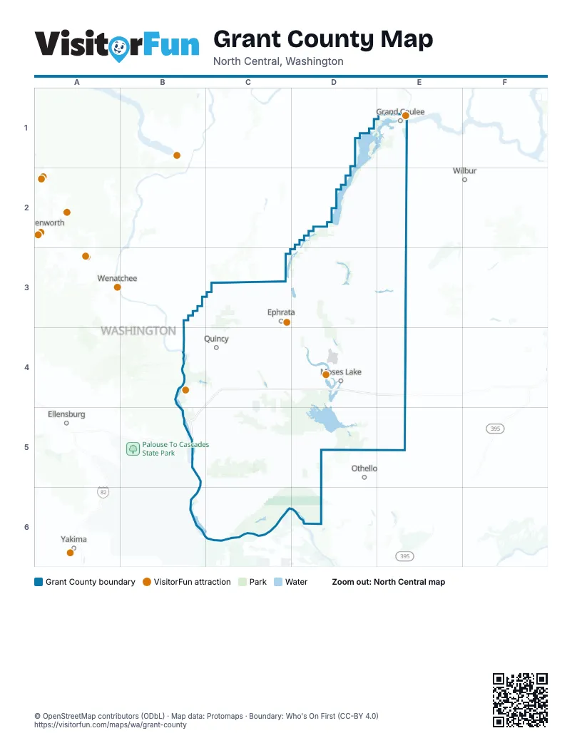
Street index of Grant County
Each street on the sheet and the grid squares it crosses.
- State Route 243B5, B6, C6
- Coulee BoulevardD1, E1, D2
- State Route 17D4, D5
- State Route 24C6, D6
- United States Highway 2 EastD2, E2
- Road 13 SouthwestC5, D5
- State Route 26 WestB5, C5, D5
- State Route 281C4
- Road 10 NorthwestB4, C4
- Road 11 NorthwestB4, C4
- State Route 28E3, B4, C4
- State Route 283 NorthC4
- Coulee CorridorD1, E1, D2, D4
- Basin Street SouthwestC3, C4
- West Broadway AvenueD4
- F Street SouthwestC3, C4
- South Pioneer WayD4
- Burke SpurC4
- Basin Street NorthwestC3
- F Street SoutheastC3, C4
- State Route 174E1
- Central Avenue SouthC4
- East Broadway AvenueD4
- North Stratford RoadD4
- East Grand Coulee AvenueE1
- West Grand Coulee AvenueE1
- Grand Coulee AvenueE1
- Midway AvenueE1
- Daisy Street NorthD3
- Highway 7D3
- Daisy Street SouthD3
- State Route 155E1
- State Route 17 NorthD3
- Vantage HighwayC6
- State Route 26D5
- Coulee Corridor / Sunset HighwayD2
- Partello PkE1
- Road U NortheastE1, E2, E3, E4
- South Frontage Road WestB4, C4, D4, B5
- Road 3 NortheastD4, E4
- Road 24 SouthwestB6, C6
- Road U SoutheastE4, E5
- O'Sullivan Dam RoadD5
- Road A SoutheastD4, D5
- White Trail RoadB4, C4
- Westshore Drive NortheastD4
- East Wheeler RoadD4
- Road 8 SoutheastD5, E5
- West Peninsula DriveD4
- Silica Road SouthwestB4, B5
- South Division StreetD4
- North Grape DriveD4
- West Valley RoadD4
- Airway Drive NortheastD4
- Patton BoulevardD4
- 3rd Avenue SouthwestC3, C4, B5
- Nat Washington WayC3
- Bridgeport HighwayE1
- West Lakeshore DriveD4
- North Central DriveD4
- West 1st StreetE5
- State Route 262 SoutheastD5
- West 3rd AvenueD4
- Patton Boulevard NortheastD4
- Hansen RoadD4
- East 1st StreetE5, B6, C6
- East Nelson RoadD4
- Central DriveD4
- East Hill StreetD4
- County RoadE5
- South Wanapum DriveD4
- Andrews Street NortheastD4
- Spokane WayE1
- East 3rd AvenueD4
- Government RoadB6, C6
- 26th Avenue NortheastD4
- West 4th AvenueD4
- Wheeler Road NortheastD4
- Federal AvenueE1
- West Rosenoff RoadE4
- East 5th AvenueD4
- South Alder StreetD4
- State Route 262 EastD5
- South Booker RoadE5
- Dogwood StreetD4
- East 1st AvenueE5
- East 4th AvenueD4
- South Locust LaneD4
- Road W NortheastE1, E2, E3, E4
- Road Q NortheastD1, D2, D3, D4
- Road P NortheastD2, D3, D4
- Road R NortheastE1, E2, E3, E4
- Road V NortheastE1, E2, E3, E4
- Road N NortheastD2, D3, D4
- Beverly-Burke Road SouthwestC4, B5, C5
- Stratford Road NortheastD3, D4
- Road L NortheastD2, D3, D4
- Frenchman Hills Road WestC5, D5
- South Frontage Road EastD4, E4
- Road O SouthwestC5, C6
- Road 11 SouthwestC5, D5
- Road 5 NorthwestC4, D4
- Martin Road NorthwestB4, C4
- North Frontage Road WestC4, D4
- Road 4 NortheastD4, E4
- Road 10 NortheastD4, E4
- Road 12 SouthwestC5, D5
- Dodson Road SouthC4, C5
- Pinto Ridge Road NortheastD2, D3
- North Frontage RoadB4, C4, D4, E4, B5
- Road O NortheastD2, D3, D4
- Road P NorthwestC3, C4
- Road X NortheastD1, E3, E4
- Road 9 NortheastD4, E4
- Road 3 SoutheastD5, E5
- Sagebrush Flats RoadC3
- Road K NortheastD2, D3, D4
- Road 4.4 NortheastD2, E2, D4
- Adams Road NorthC4
- Road U SouthwestB4, B5, B6
- Road 4 NorthwestC4, D4
- Dodson Road NorthC4
- Road R SoutheastE4, E5
- Road 12 NortheastD4, E4
- Road S SouthwestC4, B5, C5, C6
- Childers Road NorthE2
- Road 2 SoutheastD4, E4
- Road B NorthwestC3, C4
- Road 26 SouthwestB6, C6
- Road F NortheastD3, D4
- Road 25 SouthwestB6, C6
- Adams Road SouthwestC4, C5
- Road M SoutheastD4, D5
- Road 1 NorthwestB4, C4
- Sheep Canyon RoadC3
- North Frontage Road EastD4
- Road 6 NortheastD4, E4
- Adams Road SouthC5
- Road R NorthwestC4
- Road 12 SoutheastD5
- Road 1 SouthwestB4, C4
- Road 50 NortheastE1
- Road W SoutheastE4, E5
- Road 20 NorthwestC3, D3
- Road Q SouthwestC4, C5, C6
- E-NW RoadC3
- Mae Valley Road NortheastD4
- Road 23 SouthwestB6, C6
- Frontage Road WestC4
- Baseline West RoadB4, C4
- Randolph Road NortheastD4
- H Road SoutheastD5
- Silica RoadB4, B5
- Grand Coulee Hill RoadE1
- Hiawatha Road NortheastD4
- Road 5 SouthwestB5, C5
- Dodson Road NorthwestC3, C4
- Vantage Road SouthwestB5
- Baseline Road EastD4
- Road U NorthwestB4
- Road N SoutheastD4, D5
- Road Q SoutheastD4, D5
- Road O SoutheastD4, D5
- Road H NortheastD4
- Yonezawa BoulevardD4
- Valley Road NortheastD4
- Road 8.5 SoutheastE5
- Sunland RoadB4
- 24 Road NorthwestC3
- Road 5.2 NortheastE1, D4
- Rd 8 SEE5
- Frontage RoadC4
- West Marina DriveD4
- Crescent Bar Road NorthwestB4
- Frenchman Hills Road EastD5
- Wilson Creek LoopD3
- Frey RoadC3
- A Street SoutheastC3, C4
- 5th Avenue SoutheastC3, D3, C4
- Main StreetE1, E2, D3, D4, E4, B5
- C Street SouthwestC3, C4
- East Division AvenueC3
- Alder Street NorthwestC3
- 3rd Avenue NortheastC3, D3, C4
- Airport Street SoutheastC3, C4
- Beverly-Burke Road NorthwestC4
- 3rd Avenue SoutheastC3, D3, C4
- Airport StreetC3
- Railroad StreetD3, E3
- D Street SoutheastC3, C4
- 7th Avenue SouthwestC3, D3, C4
- Neva Lake RoadC4
- 1st Avenue SouthwestC3, C4
- 13th Avenue SouthwestC3, C4
- 12 Road SoutheastC3
- Potato Hill Road SoutheastD4
- 1st Avenue NorthwestC3, D3
- Columbia WayC4
- Potato Hill Road NortheastD4
- 22nd Avenue NortheastD4
- Kittleson Road NortheastD4
- Division Street EastC4
- A Street NortheastD2, C3, C4
- Jackrabbit StreetC4
- South Clover DriveD4
- Nelson Road NortheastD4
- South Balsam StreetD4
- 1st StreetE1, D3, B4
- Wanapum Drive SouthwestB4
- Royal RoadC5
- Ahlers Avenue NorthC5
- Washington WayC4
- Sprague StreetD3, E3
- Alcan Road NortheastE1
- Ottmar Road NortheastD4
- West Montmorency BoulevardC4
- B StreetE1, B4, B5
- Central Avenue NorthC4
- Urquhart AvenueE3
- Enterprise StreetC3
- Paxson DriveD4
- Dick Road NortheastD4
- Westlake RoadD4
- 13th Avenue NorthwestC3, C4
- Columbia StreetE2
- Alder Street SouthwestC3, C4
- F-SW RoadC5
- 4th StreetE1, D2, D3
- West 6th StreetE5
- D Street NortheastC3, C4
- West Ivy AvenueD4
- South Interlake RoadD4
- College Northeast ParkwayD4
- 2nd StreetE1, D3
- Martin RoadE1
- West Main StreetD2, D4
- C-NW RoadC3, C4
- Division Street WestC4
- West 8th StreetE5
- Neva Lake Road NorthwestC4
- N Street SouthwestC4
- 32nd Avenue NortheastD4
- Camelia Street NortheastC5
- Clover DriveD4
- South Ash AvenueE5
- West McManamon RoadD5
- South Mc Entee StreetD2
- Prichard Road WestD4
- West Division AvenueC3
- 30th Avenue NortheastD4
- South Oak AvenueE5
- North Fig StreetD4
- Leanne AvenueD4
- Range StreetE2
- Spokane Boulevard NortheastE1
- Grand Coulee Hill Road NortheastE1
- South Main StreetE5
- South Maiers RoadD4
- North Block StreetD4
- 5th Avenue SouthwestC3
- Frey Road NorthwestC3
- 4th Avenue NorthwestC3
- Grumman AvenueC3
- North 4th StreetD2
- South Ash StreetD4
- Weir WayE5
- North Elder StreetD4
- Royal Anne AvenueC4
- Hillside DriveE5
- Belmont AvenueD4
- South Beech StreetD4
- Cochran Road NortheastD4
- South Boundary AvenueC6
- Driggs DriveD4
- Royal Avenue NorthwestC5
- North Hamilton RoadD4
- East 9th StreetE5
- Royal Avenue SouthwestC5
- West Beck WayE5
- East 8th StreetE5
- South Frontage RoadD4, E4
- Camelia Street NorthwestC5
- South Cedar StreetD4
- West 5th AvenueD4
- East Main StreetD2
- Noble RoadE1
- Hanson Station Road EastE2
- West Hillside DriveE5
- Southwest 13th AvenueC4
- Ahlers RoadC5
- West Schrag RoadE4
- Maxwell Road EastE2
- Industrial RoadE1
- Clairmont WayE5
- Old Coulee Road NorthE1
- Hillside Drive WestE5
- Urquhart Road NorthE3
- West Lind-Warden RoadE5
- Road T NortheastE1, E2, E3, E4
- Road S NortheastE1, E2, E3, E4
Things to do on the Grant County map
Places on the map
- Alkali Lake
- Artesian Lake
- Babcock Ridge Lake
- Banks Lake
- Banks Lake South
- Barker Canyon Camping Area
- Beezley Hills Wildlife Area
- Beverly
- Beverly Dunes ORV Area
- Billy Clapp Lake
- Billy Clapp Lake Wildlife Area
- Black Lake
- Black Rock Lake
- Blue Heron Park
- Blue Lake
- Brook Lake
- Burke Lake
- Caliche Lakes
- Canal Lake
- Cascade Valley
- Columbia National Wildlife Refuge
- Corral Lake
- Coulee City
- Coyote Ridge Golf Course
- Crater Lake
- Crescent Bar
- Crescent Bar Recreation Area
- Desert Wildlife Area
- Gloyd Seeps Wildlife Area
- Lower Crab Creek Wildlife Area
- Moses Coulee
- Potholes State Park
- Priest Rapids Wildlife Area
- Quincy Lakes Wildlife Area
- Rocky Ford Wildlife Area
- Saddle Mountains West
- Seep Lakes Wildlife Area
- Steamboat Rock State Park
- Sun Lakes Wildlife Area
- Sun Lakes-Dry Falls State Park
Next to Grant County
- Ellensburg
- Leavenworth
- Othello
- Wenatchee
- Wilbur
- Yakima map
© OpenStreetMap contributors, Open Database License, openstreetmap.org/copyright · Map data: Protomaps · Boundary: Who's On First (CC-BY 4.0); Quattroshapes (CC BY 2.0)