

Washington map
Kelso map
About 12,737 people live here (Census Bureau, 2024 estimate). The sheet's index lists 242 streets; South Kelso Drive, 3rd Avenue South and South Pacific Avenue cross the most grid squares. Things to do inside the boundary: Three Rivers Mall.
Open the map (PDF, US Letter)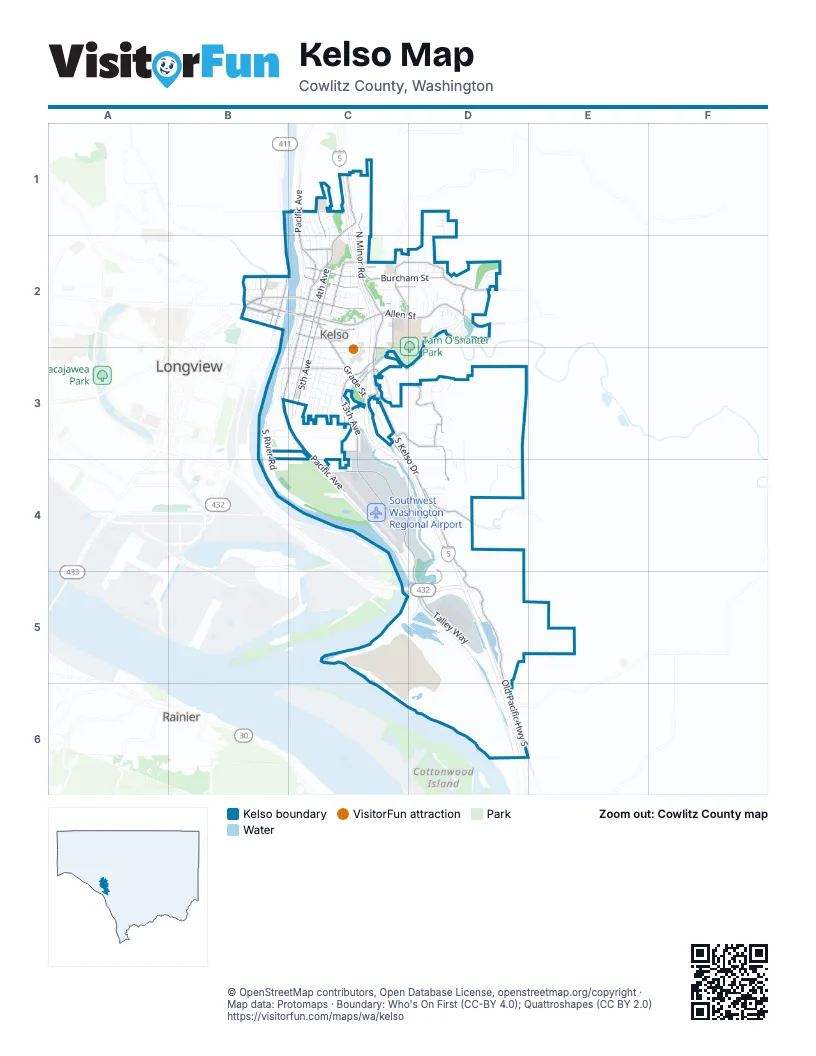
Street index of Kelso
Each street on the sheet and the grid squares it crosses.
- Barnes StreetC1
- Bowmont AvenueC1, C2
- Croy StreetC1, C2
- Florence StreetC1
- Holcomb RoadC1
- Home CourtC1, C2
- Keen StreetC1
- Lewis StreetC1
- North 1st AvenueC1, C2
- North 2nd AvenueC1, C2
- North 3rd AvenueC1, C2
- North 4th AvenueC1, C2
- North Kelso AvenueC1, C2
- North Minor RoadC1, C2
- North Pacific AvenueC1, C2
- Pacific PlaceC1
- Ross AvenueC1, C2
- Teresa WayC1
- Behshel Heights RoadD1, D2
- Preis CourtD1
- Tara CourtD1
- Tara StreetD1
- Travis CourtD1
- Travis StreetD1
- 1st Avenue NorthwestB2
- 2nd Avenue NorthwestB2
- 2nd Avenue SouthwestB2
- 4th Avenue NorthwestB2
- 4th Avenue SouthwestB2
- 5th Avenue NorthwestB2
- 5th Avenue SouthwestB2
- 6th Avenue NorthwestB2
- 6th Avenue SouthwestB2
- 7th Avenue NorthwestB2
- 7th Avenue SouthwestB2
- 8th Avenue NorthwestB2
- Allen StreetB2, C2, D2
- Catlin StreetB2
- Clark StreetB2
- Columbia Heights RoadB2
- Cowlitz WayB2, C2
- Fisher CourtB2
- Fishers CourtB2
- Fishers LaneB2
- Grant StreetB2
- Inch StreetB2
- Lane StreetB2
- Lincoln StreetB2
- Long AvenueB2
- Northwest 3rd AvenueB2
- Northwest 4th AvenueB2
- Ocean Beach HighwayB2
- Royal StreetB2
- Southwest 1st AvenueB2
- Southwest 3rd AvenueB2
- Washington StreetB2
- West Cowlitz WayB2
- West Main StreetB2
- Westside HighwayB2
- 16th PlaceC2
- 17th Avenue NorthC2
- 1st Avenue SouthC2, B3, C3
- 3rd Avenue NorthC2
- 3rd Avenue SouthC2, B3, C3, C4
- 5th AvenueC2
- Academy DriveC2
- Academy StreetC2
- Alder StreetC2, C3
- Allen DriveC2
- Ash StreetC2
- Ayers StreetC2
- Bates RoadC2, D2
- Bloyd StreetC2, D2
- Bridge Market LaneC2
- Burcham StreetC2, D2
- Canaan CourtC2
- Carolyn DriveC2
- Church StreetC2
- Columbia StreetC2
- Cowlitz StreetC2
- Cowlitz VillaC2, C3
- Crawford StreetC2
- Division StreetC2
- Donation StreetC2
- East Pineway StreetC2
- Grade StreetC2, C3
- Harris StreetC2, D2
- Holly StreetC2
- Ineer StreetC2
- Jones RoadC2, D2
- Lord StreetC2
- Mount Brynion StreetC2
- North 10th AvenueC2
- North 12th AvenueC2
- North 13th AvenueC2
- North 14th AvenueC2
- North 16th AvenueC2
- North 17th AvenueC2
- North 18th AvenueC2
- North 19th AvenueC2
- North 20th AvenueC2, D2
- North 5th AvenueC2
- North 6th AvenueC2
- North 7th AvenueC2
- North 8th AvenueC2
- North 9th AvenueC2
- North River AvenueC2
- Oak StreetC2
- Pine StreetC2
- Redpath StreetC2
- South 10th AvenueC2, C3
- South 4th AvenueC2, C3
- South 5th AvenueC2, C3
- South 6th AvenueC2, C3
- South 8th AvenueC2, C3
- South 9th AvenueC2, C3
- South Kelso DriveC2, C3, C4, D4, D5
- South Maple StreetC2
- South Pacific AvenueC2, B3, C3, C4
- Sunnyside StreetC2
- Sunrise StreetC2, D2
- Tam O'Shanter WayC2, C3
- Three Rivers Drive EastC2
- Vine StreetC2
- Wood AvenueC2
- Abbotsford LoopD2
- Barr DriveD2
- Beaver LaneD2
- Bluebird LaneD2
- Bounder LaneD2
- Cardinal LaneD2
- Clydesdale LaneD2
- Corduroy RoadD2
- Crescent DriveD2
- Dynasty CircleD2
- Edinburgh CourtD2
- Evelyn CircleD2
- Glenmore StreetD2
- Graham DriveD2
- Harris Street RoadD2
- Kingfisher LaneD2
- Mayfield Garden RoadD2
- Meadowlark LaneD2
- Miller DriveD2
- Mockingbird LaneD2
- Nightingale LaneD2
- North 21st AvenueD2
- North 22nd AvenueD2
- North 23rd AvenueD2
- North 24th AvenueD2
- North Crescent DriveD2
- Osprey LaneD2
- Peacock LaneD2
- Robert CourtD2
- Sparrow LoopD2
- Spruce StreetD2
- Stardust LaneD2
- Sunrise CourtD2
- Swanson RoadD2
- Tanager LaneD2
- Tweed CourtD2
- Winnebago LaneD2
- Elm StreetB3, C3
- Hawthorne StreetB3, C3
- Laurel StreetB3, C3
- Mill StreetB3, C3
- Olive StreetB3, C3
- Riverside DriveB3
- Rosewood StreetB3
- South River RoadB3, B4, C4
- Virginia StreetB3, C3
- Willow StreetB3, C3
- Yew StreetB3, C3
- Cedar StreetC3
- Cherry StreetC3
- Chestnut StreetC3
- Clinton StreetC3, C4
- Coweeman DriveC3
- Coweeman LaneC3
- Coweeman River TrailC3, D5
- Crestwood LaneC3
- East Terrace WayC3
- Elizabeth StreetC3
- Elm PlaceC3
- Grim RoadC3, D3
- Hancock StreetC3
- Haussler RoadC3, D3, D4
- Hazel StreetC3
- Jefferson StreetC3
- Kinnear StreetC3
- Lowrane DriveC3, D3
- Manacso DriveC3
- Milwaukee PlaceC3
- North Alma DriveC3
- South 11th AvenueC3
- South 12th AvenueC3
- South 13th AvenueC3, C4
- South 7th AvenueC3
- Three Rivers DriveC3
- Three Rivers Drive WestC3
- Valley View DriveC3
- Walnut StreetC3
- Aldercrest DriveD3
- Apple LaneD3
- Azalea CourtD3
- Banyon DriveD3
- Cedar Glen DriveD3
- Cris RoadD3, D4
- Greenwood CourtD3
- Haussler Spur RoadD3
- Highland Park DriveD3
- Mimosa DriveD3
- North Vista WayD3, D4
- Rons CourtD3
- Sunnyside DriveD3
- Tybren Heights RoadD3, D4
- West Highland Park DriveD3
- West Vista WayD3, D4
- Fairway DriveB4
- Baker WayC4
- Colorado StreetC4
- Douglas StreetC4
- Old Talley WayC4, D4, D5
- Parrott WayC4
- Talley WayC4, D4, D5
- Carroll RoadD4
- Cedar Falls DriveD4
- Emerald CourtD4
- Krystle CourtD4
- Marina RoadD4, D5
- Overlook DriveD4
- Paxton RoadD4
- Rodi DriveD4
- Roley CourtD4
- Ruby CourtD4
- South Vista WayD4
- Kelso DriveD5
- Old Pacific Highway SouthD5, D6, E6
- Pare RoadE5
- Norwood DriveD6
- Vision DriveD6
- Isaacson DriveE6
Things to do on the Kelso map
Places on the map
- A&A Self Storage
- Abundant Life Church of the Nazarene
- ampm
- Asian Buffet
- Barnes Elementary School
- Best Western Aladdin Inn
- Boondox Gas & Grocery
- Brookhollow RV Park
- Burger King
- Burgerville
- Butler Acres Elementary School
- Cap'n Yoby's
- Catlin Elementary School
- Central Christian Church
- Central Welding Supply
- Comfort Inn
- Cost Less Auto Parts
- Coweeman Middle School
- Cowlitz 2
- Cowlitz County Courthouse
- Cowlitz County Historical Museum
- Cowlitz Way Baptist Church
- Denny's
- Dick Hannah Toyota
- DQ Grill & Chill
- East Hills Alliance Church
- East Kelso Baptist Church
- Econo Lodge Kelso
- Ed Laulainen Stadium
- Faith Lutheran Brethren Church
- Fellowship Assembly of God Church
- Fibre Federal
- Fibre Federal Credit Union
- Fiesta Bonita
- Huntington Middle School
- Kelso High School
- Southwest Washington Regional Airport
- Tam O'Shanter Park
- Three Rivers Crossing
- Three Rivers Golf Course
Next to Kelso
- Longview map
- Rainier
© OpenStreetMap contributors, Open Database License, openstreetmap.org/copyright · Map data: Protomaps · Boundary: Who's On First (CC-BY 4.0); Quattroshapes (CC BY 2.0)















