

Washington map
Cowlitz County map
About 113,982 people live here (Census Bureau, 2024 estimate). The sheet's index lists 300 streets; Dike Road, Spirit Lake Highway and Lewis River Road cross the most grid squares. Things to do inside the boundary: Three Rivers Mall.
Open the map (PDF, US Letter)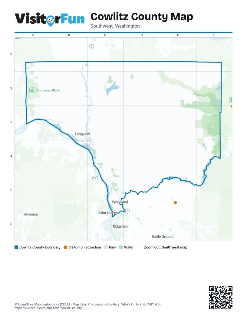
Maps inside Cowlitz County
2 maps inside, from the street map of Cowlitz County down.
Street index of Cowlitz County
Each street on the sheet and the grid squares it crosses.
- Tennant WayB3, B4, C4
- Lewis River RoadF4, C5, D5, E5, F5
- Ocean Beach HighwayA3, B3
- Allen StreetB3, C3
- Industrial WayB3, B4
- Washington WayB3
- Mount Solo RoadB3
- Oregon WayB3, B4
- 15th AvenueB3, B4
- 3rd AvenueB3, B4
- Huntington Avenue SouthC2
- Willow Grove Connection RoadB3
- Cowlitz WayB3, C3
- North 4th AvenueC3
- Catlin StreetB3
- Huntington Avenue NorthC2
- Pacific AvenueC5
- Atlantic AvenueC5
- Lewis and Clark BridgeB4
- West Cowlitz WayB3
- Mount Saint Helens Way NortheastC2
- North 5th AvenueC3
- East CC StreetC5
- Bridge 80C5
- Spirit Lake HighwayD1, E1, C2, D2, E2, F2
- Westside HighwayB1, B2, C2, B3, C3
- Kalama River RoadC4, D4
- Coal Creek RoadB2, B3
- Old Pacific Highway SouthC4, C5
- Pacific WayB3
- Yale Bridge RoadE5, F5
- South Kelso DriveC3, C4
- Oak StreetB3, C3, C4
- Talley WayC3, C4
- Dike Access RoadC5
- State Highway 505D1
- 7th AvenueB3
- Grade StreetC3
- Louisiana StreetB3
- 16th AvenueB3, B4
- 17th AvenueB3, B4
- Commerce AvenueB3
- Guild RoadC5
- Old Pacific HighwayB2, C2, C5
- Colorado StreetB3, C3
- Northwest Nichols BoulevardB3
- South 4th AvenueB3, C3
- South 13th AvenueC3
- South 5th AvenueB3, C3
- Larch StreetB3, D5
- Morse StreetB1
- North Pekin RoadC5
- Elm StreetB3, C3, C4
- Schurman WayC5
- Northeast Frontage RoadC4
- North Goerig StreetC5
- West Frontage RoadC4
- Nichols BoulevardB3
- Cottonwood DriveC4, C5
- Southwest 1st AvenueB3
- Lexington Bridge DriveC3
- East Scott AvenueC5
- Ph 10B2
- A StreetB2, C2, C5
- West Main StreetB3
- Davidson AvenueC5
- Goerig StreetC5
- Marina RoadC4
- Kelso DriveC4
- 1st Avenue NorthwestB3
- Tennant Way FrontageB3
- Southwest A StreetB2
- Rose Valley RoadC3, D3, C4
- Merrill Lake RoadF3, F4
- Dike RoadB2, C2, B3, B4, C4, C5, C6, D6
- Tower RoadC1, D1, C2
- Green Mountain RoadC5
- Little Kalama River RoadD4, D5
- Willow Grove RoadA3, B3
- South Toutle RoadD1, C2, D2
- Mount Pleasant RoadC4
- South Silver Lake RoadC2
- Columbia Heights RoadB3
- Delameter RoadB2
- Hazel Dell RoadB2, B3
- Pleasant Hill RoadC2, C3
- Barnes DriveB1, C1, B2
- Mount Brynion RoadC3
- Holcomb RoadC3
- China Garden RoadC4, C5
- Headquarters RoadC2, C3
- North Pacific AvenueB3, C3
- Woodside DriveB2, B3
- Permanent Highway 10B2
- Cloverdale RoadC4, C5
- South Cloverdale RoadC5
- Ostrander RoadC3
- Modrow RoadC4
- George Taylor RoadC2
- Bond RoadC2, C3
- Old Pacific Highway NorthB2, C2
- Pacific Highway NorthC3
- Sightly RoadC2, D2
- Butte Hill RoadD5
- Hendrickson DriveC4, C5
- South Pekin RoadC5, C6, D6
- Kool RoadC4
- Schaffran RoadC2
- Spencer Creek RoadC4
- Beech StreetB3
- 30th AvenueB3
- 32nd AvenueB3
- Carroll RoadC3, C4
- Fishpond RoadC4
- Meeker DriveC4
- Caples RoadC5
- 38th AvenueB3
- Olympia WayB3
- Maple StreetB3, C5
- Fibre WayB4
- North Hendrickson DriveC4
- Whalen RoadC5, C6
- Douglas StreetB3, C3, C4
- Shirley Gordon RoadC5
- South Pacific AvenueB3, C3
- Military RoadB2, C4, C5
- Fir StreetB3, C4
- Hudson StreetB3
- Hemlock StreetB3
- Imboden RoadB1
- 18th AvenueB3, B4
- Carnine RoadC2
- Kuhnis RoadC5, C6
- 11th AvenueB3, B4
- Florida StreetB3
- Baltimore StreetB3
- Bates RoadC3, C4
- South Goble Creek RoadC3
- 14th AvenueB3, B4
- Martins Bluff RoadC5
- Cascade WayB3
- Ohio StreetB3
- 42nd AvenueB3
- Laurel RoadB3
- Robinson RoadC5
- 9th AvenueB3
- Broadway StreetB3
- North Goble Creek RoadC3
- Burcham StreetB3, C3
- Swanson WayB4, C4
- 12th AvenueB3
- Insel RoadC5
- Hall RoadC2
- Lane RoadC5
- Powell RoadC2, D5
- Alabama StreetB3, B4
- North Minor RoadC3
- Cline RoadB2
- Delaware StreetB3
- Gore RoadC5
- California WayB3, B4
- Haussler RoadC3
- Kessler BoulevardB3
- Washington StreetB3, C5
- Prudential BoulevardB3
- Sunrise StreetC3
- Grim RoadC3
- Harris Street RoadC3
- Harris StreetB3, C3
- Dougherty Drive NortheastC2
- Gun Club RoadC5
- Ash StreetB3, C3, D5
- North Kelso AvenueC3
- Columbia BoulevardB4
- East Kessler BoulevardB3
- Vandercook WayB3
- Front Avenue SouthwestC2
- Columbia StreetB3, C3, C5
- Parrott WayC3, C4
- Mill StreetB3, C3
- Streeter RoadC2
- Lakeshore DriveC5
- Todd RoadC5
- Down River DriveC5
- Coldwater Ridge Visitors Center RoadF2
- North 2nd StreetC4
- Park StreetC5
- Pinkerton DriveC5
- North 7th AvenueC3
- 3rd Avenue SouthwestB2
- 2nd Avenue SouthwestB2, C2, B3
- West Scott AvenueC5
- 5th StreetB1, C5
- Tam O'Shanter WayC3
- Hazel StreetB3, C3
- North Alma DriveC3
- Shenandoah RoadC2
- Fishers LaneB3
- North 1st StreetC4
- Bozarth AvenueC5
- Manacso DriveC3
- Port RoadC5
- Crestwood LaneC3
- Highland Park DriveC3
- West Port WayB4
- Coweeman DriveC3
- Mount Brynion StreetC3
- Cowlitz Street EastC2
- South 1st StreetC4
- Buckeye StreetC5
- Redpath StreetB3, C3
- North 3rd StreetC4
- Corduroy RoadC3
- Burke RoadC5
- Robb RoadC5
- 5th Avenue NorthwestB3
- Vincent RoadC5
- Northeast Nichols BoulevardB3
- Glenwood StreetC5
- Clinton StreetC3
- Long AvenueB3
- North 18th AvenueC3
- Sandra RoadC2
- Cowlitz Street WestB2, C2
- Rose Valley Loop RoadC3
- Front Avenue NorthwestC2
- Mitchell AvenueC5
- Wheeler StreetB3
- Kingwood StreetC4
- H StreetB4
- Barr StreetC2
- Wisconsin Truck TrailA2, B2
- Logging 1600 RoadC2, C3, D3
- Castle Rock Truck TrailB1, B2
- Abernathy Creek RoadA2, A3
- Harmony DriveA2, B3
- Road 7600F3, F4
- Mosquito Creek RoadA2, B2
- Germany Creek RoadA2, A3
- Mill Creek RoadA3
- Stella RoadA3, B3
- Old Lewis River RoadD5
- Road 7280F4
- Otto Cook RoadD1
- Canal RoadC2, D2
- Italian Creek RoadC4, D4
- Mountain View RoadC4
- Road 7281F4
- East and West Truck TrailB2
- Eufaula Heights RoadB3
- Slide Creek RoadA2, A3
- Logging 1650 RoadD3
- Burma RoadB2, C2
- Road 7288F4
- Road 7200F4
- Sandy Bend RoadB2, B3, C3
- Bodine RoadC4
- North Mahafrey RoadC3
- Clark Creek RoadB3
- Walker RoadC3, C4
- Oak Point RoadA3
- Lone Oak RoadB3
- Greenwood RoadC4, D4
- Atmore RoadD2
- North mahaffey RoadC3, D3
- Abernathy Truck TrailA2, B2
- Westshore RoadC2
- Sommerset RoadC5
- Road 7500F3, F4
- Paine RoadC2
- Finkas RoadD1
- Road 7284F4
- Leubke RoadD2
- Chapman RoadB2
- Frank Smith RoadD2
- Pennsylvania StreetB3
- McKee RoadB2, B3
- Ragland RoadB3
- Road 7616F4
- Neimi RoadD5
- 20th AvenueB3, B4
- Road 7205F3, F4
- Melton RoadB2
- Confer RoadC5
- Beacon Hill DriveB3
- Frasier RoadE5, F5
- Forest Road 8303F3
- 23rd AvenueB3
- 22nd AvenueB3
- 21st AvenueB3
- Sauer RoadC5
- Hansen RoadC2, C4, D5
- Allender RoadB1
- Road 7540F3, F4
- Sunset WayB3
- Bayswater RoadE5
- Misty Hill DriveC2, D2
- Agren RoadB1
- Fall Creek RoadA3
- Fallert RoadC4
Things to do on the Cowlitz County map
Places on the map
- Abernathy Creek Wildlife Area
- Beacon Hill
- Beaver Bay
- Canal Road Wildlife Area
- Carroll Road Quarry
- Castle Lake
- Castle Rock
- Cougar
- Cougar Park
- Elochoman Block
- Fisher Island Wildlife Area
- Gardner Wildlife Area
- Goat Marsh
- Hall Road Wildlife Area
- Headquarters Landfill
- Hoffstadt Wildlife Area
- Horseshoe Lake
- Kalama
- Kelso
- Lake Sacajawea
- Lake Sacajawea Park
- Lewis and Clark Bridge
- Lewis River Golf Course
- Lexington
- Log Pond
- Longview
- Longview Country Club
- Longview Heights
- Merrill Lake
- Merrill Lake Campground
- Merrill Lake Wildlife Area
- Mint Valley Golf Course
- Mudflow Wildlife Area
- Nelson Wildlife Area
- Riverdale Vintage MX Track
- Saddle Dam Recreation Area
- Seaquest State Park
- Silver Lake
- Southwest Washington Regional Airport
- Tam O'Shanter Park
Next to Cowlitz County
- Battle Ground map
- Ridgefield map
- Saint Helens
- Vernonia
© OpenStreetMap contributors, Open Database License, openstreetmap.org/copyright · Map data: Protomaps · Boundary: Who's On First (CC-BY 4.0); Quattroshapes (CC BY 2.0)















