

Washington map
Longview map
About 38,294 people live here (Census Bureau, 2024 estimate). The sheet's index lists 300 streets; Olympia Way, Ocean Beach Highway and Industrial Way cross the most grid squares. Also on it: Lake Sacajawea, Lake Sacajawea Park and Longview Country Club.
Open the map (PDF, US Letter)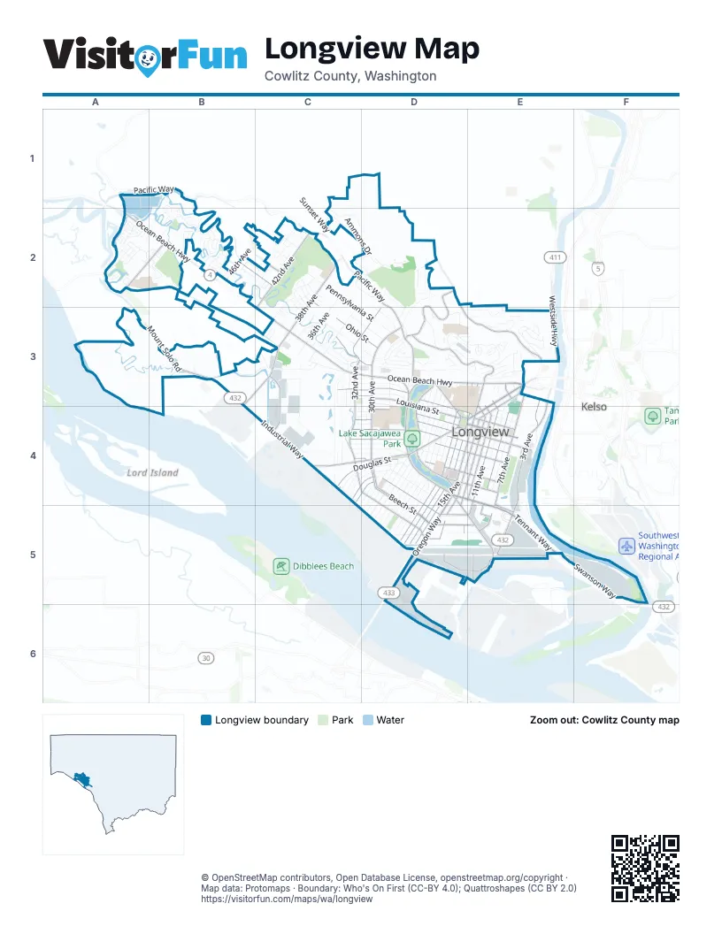
Street index of Longview
Each street on the sheet and the grid squares it crosses.
- Ocean Beach HighwayA2, B2, C3, D3, E3
- Washington WayE3, C4, D4, E4
- Tennant WayD4, E4, E5
- Oregon WayD4, D5
- 15th AvenueE3, D4, E4, D5
- 3rd AvenueE3, E4, E5
- Industrial WayB3, B4, C4, D5, E5
- Mount Solo RoadA2, B2, B3
- Catlin StreetE3
- West Cowlitz WayE3
- Pacific WayB1, C2, D2, D3
- 7th AvenueE3, E4, E5
- Louisiana StreetC3, D3, D4, E4
- 16th AvenueE3, D4, E4, D5
- 17th AvenueE3, D4, D5
- Commerce AvenueE3, D4, E4, D5
- Northwest Nichols BoulevardD3, D4
- Larch StreetD4
- Nichols BoulevardD4
- Westside HighwayE3
- Southwest 1st AvenueE3, E4
- Tennant Way FrontageE4, E5
- Beech StreetC4, D4, D5, E5
- 30th AvenueD3, D4
- 32nd AvenueC3, D3, C4, D4
- 38th AvenueC2, B3, C3
- Maple StreetC3, D3, D4, E4
- Columbia Heights RoadD2, D3, E3
- Olympia WayB2, C2, C3, D3, D4, E4
- Hudson StreetC4, D4, E4
- Hemlock StreetC4, D4, E4
- 18th AvenueE3, D4, D5
- 11th AvenueE3, E4, D5, E5
- Florida StreetC4, D4, E4
- Baltimore StreetC4, D4, D5, E5
- Douglas StreetC4, D4, E4
- 14th AvenueD4, E4, D5
- Cascade WayD3, E3
- Laurel RoadD2, D3
- 9th AvenueE3, E4, E5
- Broadway StreetD4, E4
- 12th AvenueE3, E4
- Alabama StreetD4, D5
- 42nd AvenueC2
- Ohio StreetC2, C3, D3
- Delaware StreetC4, D4, E4
- California WayD4, D5, E5
- Kessler BoulevardD3, D4
- Prudential BoulevardC3, C4
- Columbia BoulevardD5, E5
- East Kessler BoulevardD4
- Vandercook WayE3, E4
- Swanson WayE5, F5
- Fibre WayE5
- Washington StreetE3
- Northeast Nichols BoulevardD3
- Wheeler StreetE5
- H StreetD5
- West Port WayD5
- 20th AvenueD3, D4, D5
- 23rd AvenueD3, D4, D5
- 22nd AvenueD3, D4, D5
- 21st AvenueD3, D4, D5
- Oak StreetC2, C3, D3
- Pennsylvania StreetC2, C3, D3
- 19th AvenueD3, D4, D5
- Fir StreetC4, D4, E4
- 28th AvenueD3, D4, D5
- Cypress StreetC4, D4, D5
- 24th AvenueD3, D4, D5
- Memorial Park DriveB3, C3
- 25th AvenueD3, D4, D5
- 26th AvenueD4, D5
- 27th AvenueD3, D4, D5
- 8th AvenueE3, E4
- 33rd AvenueC3, C4
- Ammons DriveC2, D2
- Terminal WayD5, D6
- 36th AvenueC2, C3
- Colorado StreetC4, D4
- Freedom WayF5
- 10th AvenueE3, E4
- Pine StreetC2, C3, D3
- 34th AvenueC3, C4
- Oriole DriveB1, B2
- City View BoulevardD3, E3
- Blue Heron DriveA2
- Terry AvenueD3
- Maryland StreetC3, D3
- Branch Creek DriveA2, B2
- Field StreetC4, D4
- Garfield StreetC4, D4
- Glenwood DriveD2, D3
- Morse Park WayB2
- 46th AvenueB2
- Maplewood DriveE3
- Hillcrest DriveD3, E3
- Taylor AvenueD3
- Snooks Trailer ParkA2, B2
- Olive WayC3
- Dover StreetC4, D4
- Nebraska StreetC3
- Schneiter DriveA2
- Michigan StreetC3, D3, E4
- Sewage Lagoon StreetA1, B1
- Paper WayD5
- Port WayD5
- Rosewood StreetC2
- West Lynnwood DriveE3
- 50th AvenueB2
- 52nd AvenueB2
- Virginia WayD2
- Magnolia StreetD3
- Sunset WayC2, D2
- Solo View DriveB3
- Castleman DriveE3
- Northlake AvenueD3
- Pacific PlaceC2, D2
- 29th AvenueC4, D4
- Alaska StreetD5, E5
- Marine View DriveE4, E5
- Weber AvenueC3, C4
- 40th AvenueC2, C3
- River RoadE4
- Henderson WayA2
- Madrona DriveD3
- Robbins StreetB2
- Finch DriveB1, B2
- Weber Avenue SouthC4
- Pershing WayD3
- Totem LaneB2, C2
- Lilac StreetD3, D4
- 48th AvenueB2
- View Ridge CircleE3
- Heritage BoulevardA2
- West Hills DriveD3
- Cedar PlaceD3, E3
- Wildwood DriveD2, D3
- Arkansas StreetD5
- Windemere StreetB2
- Trillium HeightsE3
- Lindsey DriveD2
- Sycamore PlaceE3
- Tori LaneC3
- Willow Point LoopA2
- Crocker AvenueC3
- East Linwood DriveE3
- Park Hill DriveE3
- Corman RoadD3
- Forest Hill EstatesE3
- Alder StreetC4
- Hickory AvenueB2
- Estate DriveC3
- Constitution LaneB2, C2
- Curtis DriveC1, C2
- Acorn LaneC2
- International WayD5
- Aspen DriveB2
- New York StreetE4
- Indian Creek DriveD2
- Merlin StreetB2
- Greenway AvenueC2
- Indian Hills DriveD2
- Parkview DriveD3
- West Castleman StreetE3
- Peardale LaneE4
- Carolina StreetC4
- Island DriveA2
- Archwood DriveE3
- Olympia PlaceC2
- Fishers LaneE3
- Spruce StreetE3
- 37th AvenueC3
- Sandpiper RoadE3
- Hoehne AvenueC4
- Rutherglen DriveC3
- Park PlaceD3
- Fairway LaneD2
- Independence LaneB2, C2
- South Clark StreetE3
- Redwood AvenueB2
- Susan AvenueC3, C4
- Gibbs LaneD3, E3
- Lee AvenueB2
- Harding StreetD4
- Cottonwood StreetC2, C3
- Concord PlaceA2
- Gardenia StreetC2
- William AvenueC4
- Mulberry AvenueB2
- Florence AvenueC3, C4
- Bethany StreetA2
- Terumi LaneC2
- Dorothy StreetC3, C4
- Country Club DriveD2, D3
- East Cedar LaneE3
- Grove StreetA2, B2
- Crestline PlaceE2
- Chinook StreetD2
- Cherrywood StreetC2
- Sadie LaneA2
- Scott StreetC3
- West Pine LaneC2
- Canyon PlaceE3
- Jennifer PlaceC3
- Hawthorne StreetC4, D4
- Center CourtE3
- 31st AvenueD4
- Ivy AvenueC2
- Tibbetts DriveC3
- 35th AvenueC3
- Laurel PlaceD3
- East Lynnwood DriveE3
- West Point DriveA2
- Paradise DriveE3
- Huntington PlaceD3
- Sires LaneC2
- Clark StreetE3
- Dorothy AvenueC3
- Laurel Park DriveD3
- Melody WayA2
- Marigold StreetC4, D4
- Lynnwood DriveE3
- Curtis LaneC2
- Wren DriveB2
- Elm StreetE3
- Rose PlaceC3
- Jathom LaneC3
- Monterey PlaceD3
- Crestline DriveD2, E2
- Cascade DriveE3
- R A Long BoulevardD4
- Quail LaneA2
- Regency PlaceC2
- Jeffery PlaceD3
- North Ammons DriveC2
- Lincoln StreetE3
- Virginia PlaceD2
- Kansas StreetC4, D4
- Lynn PlaceD2
- Southwest 3rd AvenueE3
- Willow PlaceE3
- Beverly StreetB2
- Ocean Beach PlaceD3
- Mignonne CourtD3, E3
- Dyanna DriveA2, B2
- Northlake PlaceD3
- Judith PlaceD3
- Barlow Point RoadA3
- Independence CourtB2
- Midland AvenueC4
- Triangle MallE3
- McAtee DriveE3
- Julie PlaceB2
- Franklin PlaceA2
- Heritage PlaceA2
- Jimmer PlaceC3
- Cowan CourtC3
- Bradford PlaceB3
- Lynnwood Drive EastE3
- West Pine CourtC2
- Cedar LaneE3
- Madrona PlaceD3
- Greyhawk LaneA2
- Triangle Shopping CenterE3
- Gracie PlaceC2
- Olympia LaneC2
- Selix LaneD2
- Tree Top RoadD3
- East Castleman StreetE3
- Larry LaneC3
- Nicola LaneB2
- Mallard LaneA2
- Pheasant LaneA2
- Sunset DriveC1
- Chinook CourtD2
- Clearview DriveC2
- Arlington PlaceA2
- Horizon CourtA2
- Love CourtE3
- Shelly PlaceC3
- Canary CourtB2
- Greenview LaneC2
- Egret LaneA2
- Philips CourtC2
- Pintail LaneA2
- Mark Morris CourtE3
- Oriole CourtB2
- Terry CourtD3
- Floral CourtC3, C4
- Orchid CourtD3, D4
- Premiere PlaceD3
- Hickory CourtB2
- Swallow CourtB2
- Heron StreetB2
- Champ PlaceC3
- Olive CourtC3
- Woodthrush StreetB1, B2
- Hill StreetE3
- Northlake CourtD3
Places on the map
- 7th Avenue Park
- Altrusa Park
- Archie Anderson Park
- B&R Mini Storage
- Baker's Corner Plaza
- Bud Clary Chevrolet
- Canterbury Inn
- Canterbury Park
- Cascade Middle School
- Cloney Park
- Columbia Ford
- Cowlitz County Event Center
- David B. Story Field
- Driving Range
- Fred Meyer
- Gerhart Gardens Park
- Huntington Rock
- John Null Park
- Kessler Elementary School
- Lake Sacajawea
- Lake Sacajawea Park
- Longview Country Club
- Lowe's
- Mark Hoehne Park
- Mark Morris High School
- McCord's Dodge
- Mint Valley Elementary School
- Mint Valley Golf Course
- Mount Solo Middle School
- Northlake Elementary School
- Ocean Beach Self Storage
- Olympic Elementary School
- PeaceHealth St. John Medical Center
- R.A. Long High School
- Ray Morse Disc Golf Course
- Roy Morse Park
- Saint Helens Elementary School
- Solo Storage
- The Home Depot
- Triangle Shopping Center
Next to Longview
© OpenStreetMap contributors, Open Database License, openstreetmap.org/copyright · Map data: Protomaps · Boundary: Who's On First (CC-BY 4.0); Quattroshapes (CC BY 2.0)















