

Washington map
Mount Vernon map
About 35,344 people live here (Census Bureau, 2024 estimate). The sheet's index lists 300 streets; East College Way, Riverside Drive and North 4th Street cross the most grid squares. Things to do inside the boundary: Littlefield Celtic Center, Skagit Valley Food Co-op and Skagit Valley Tulip Festival.
Open the map (PDF, US Letter)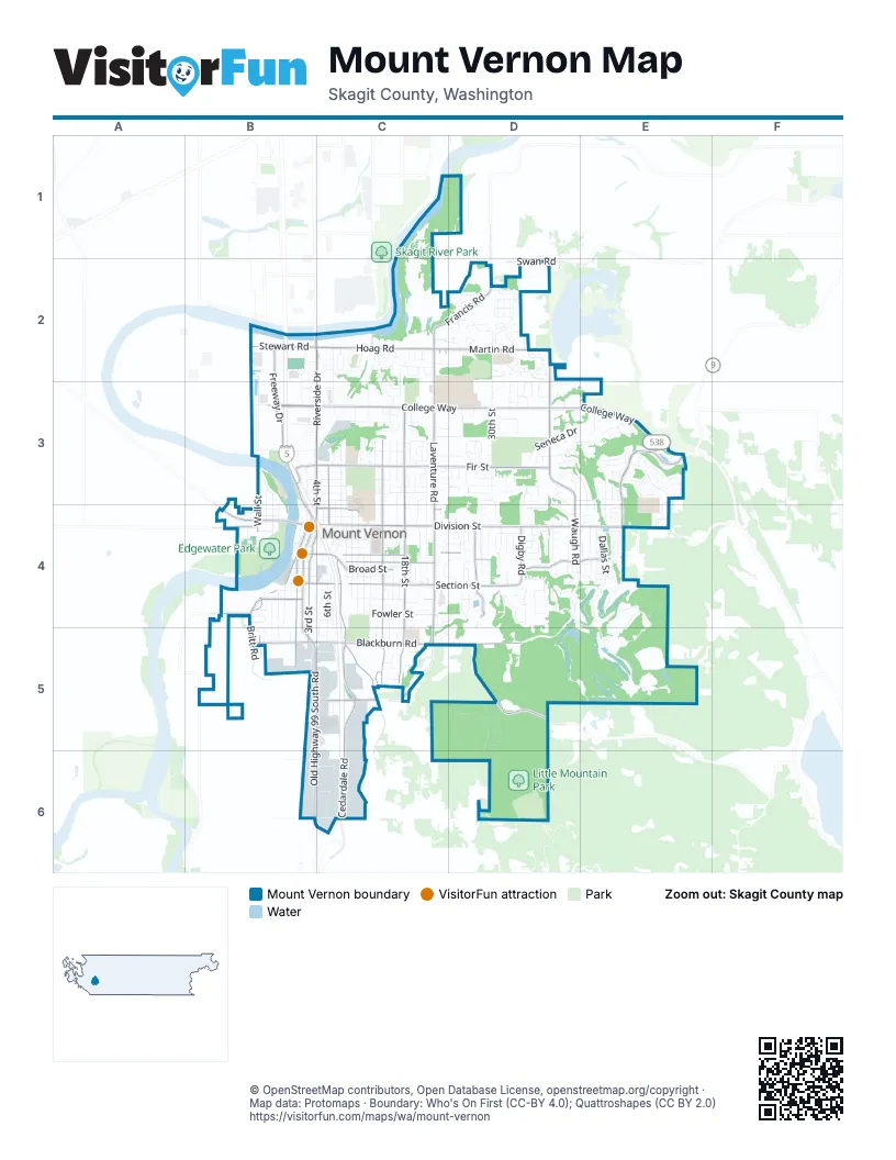
Street index of Mount Vernon
Each street on the sheet and the grid squares it crosses.
- South 3rd StreetB4, C4, B5
- West Division StreetB4
- East Kincaid StreetC4, D4
- Broad StreetC4
- West Kincaid StreetB4, C4
- Memorial HighwayB4
- East College WayB3, C3, D3, E3
- Riverside DriveB2, C2, B3, C3
- South 2nd StreetB4, B5
- North 4th StreetB3, C3, B4, C4
- West College WayB3
- College WayD3
- East Division StreetC4, D4, E4
- East Fir StreetB3, C3, D3
- East Blackburn RoadB5, C5, D5
- North Laventure RoadC2, C3, C4
- Skagit Highlands ParkwayE3, E4
- East Broadway StreetC4, D4, E4
- East Section StreetB4, C4, D4
- Freeway DriveB2, B3, B4
- Cedardale RoadC5, C6
- South 15th StreetC4, C5
- South Laventure RoadC4, C5
- Old Highway 99 South RoadB5, B6
- Blodgett RoadC4, C5
- South 18th StreetC4, C5
- Martin RoadC2, D2
- North Waugh RoadD3, D4
- North 18th StreetC3, C4
- Hoag RoadB2, C2
- Little Mountain RoadD5
- Cleveland AvenueB4, B5
- Francis RoadC2, D2
- South 27th StreetD4
- Anderson RoadB5, C5
- North 15th StreetC3, C4
- South 1st StreetB4
- West Blackburn RoadB5
- West Hazel StreetB4
- North 6th StreetC3, C4
- Digby RoadD4
- Britt RoadB4, B5
- East Fulton StreetC4
- McLean RoadB4
- North Martin RoadD2, D3
- Swan RoadD2
- Dike RoadB4
- West Stewart RoadB2
- East Stewart RoadB2
- South Wall StreetB4, B5
- West Section StreetB4
- Cameron WayB3
- West Fir StreetB3
- Old Highway 99 SouthB5, B6
- Mount Vernon Big Lake RoadE4
- Stewart RoadB2
- North 30th StreetD2, D3, D4
- Eaglemont DriveD4, E4, E5
- Little Mountain Park RoadD5, D6
- South 13th StreetC4, C5
- Roosevelt AvenueB3, C3
- South Waugh RoadD4
- Apache DriveD3
- Alpine View DriveE4
- South 6th StreetC4, C5
- Lilac DriveD3, E3, D4, E4
- South 10th StreetC4, C5
- South 11th StreetC4
- North 8th StreetC3, C4
- South 25th StreetC4, D4
- South 7th StreetC4
- South 30th StreetD4, D5
- North Trumpeter DriveD2
- Seneca DriveD3, E3
- South 28th StreetD4
- Crested Butte BoulevardE3, E4
- Fowler StreetC4
- Comanche DriveD3
- Continental PlaceC2, C3
- North 17th StreetC3, C4
- East Montgomery StreetB4, C4, D4
- South 12th StreetC4
- South 16th StreetC4, C5
- South 20th StreetC4, C5
- East Hickox RoadC6, D6
- Skagit Valley Mobile ManorD3
- Shantel StreetE4
- Urban AvenueC2, C3
- Beaver Pond Drive SouthE4, E5
- East Hazel StreetC4
- Trumpeter DriveD2
- Twin Brooks DriveE3, E4
- South 26th StreetD4
- Henson RoadC5
- Market StreetB2, B3
- North 21st StreetC3, C4
- Lindsay LoopD4
- Mount Baker LoopE3
- North 14th StreetC3
- Dallas StreetE4
- South 38th PlaceD4
- North 9th StreetC3, C4
- Loch Ness LoopD2
- North 18th PlaceC2, C3, C4
- South 9th StreetC4
- Arbor StreetD2
- North 16th StreetC3
- Beaver Pond Drive NorthE4, E5
- East Highland AvenueC3
- Timberridge DriveE3
- Woodland DriveD4, D5
- South 19th StreetC4, C5
- Behrens Millett RoadB4
- Monica DriveC2, D2
- East Skagit StreetC4
- McLaughlin RoadD2, E2
- Shoshone DriveD3, D4
- South Mount Baker DriveB3
- South Walter StreetB4, B5
- Eaglemont PlaceD4
- Woodridge AvenueC2
- Cascade WayB3
- Trumpeter BoulevardD2
- Panorama RidgeE3
- Pacific PlaceB2, C2
- Douglas StreetB4, B5
- Warren StreetC4
- East Moody StreetC4, D4
- North 1st StreetB3, B4
- Windsor DriveC2, C3
- East Carpenter StreetC4, D4
- Chestnut LoopE4
- Hickox RoadB6
- River Bend RoadB2, B3
- South 14th StreetC4, C5
- Cherokee LaneD3
- Virginia StreetB4
- Olympic DriveB3
- East Spruce StreetB3, C3
- William WayC3
- Briarwood CircleD2
- Sioux DriveD3, D4
- Grand AvenueC4, D4, C5
- Thillberg RoadD2
- South 48th StreetE4
- Manito DriveD3, D4
- South 4th StreetB4, C4
- River Vista LoopD2
- Tundra LoopD3
- Sandalwood StreetC2
- Hillcrest ParkwayC5
- Vera CourtB4
- West Lincoln StreetB4
- Stanford DriveC3, C4
- Cosgrove StreetB4
- North 32nd PlaceD2, D3
- Montgomery PlaceC4, D4, E4
- Barry LoopD4
- Digby LaneD4
- Brittany StreetE4
- Mohawk DriveD3
- Parker WayC3
- Commercial StreetB3, C3
- North Barker StreetB3, B4
- Monarch BoulevardE3
- Philip's West LoopD4
- Club CourtD2
- Philip's East LoopD4
- Hollydale Acres LaneC5
- Leann StreetD4
- Summersun StreetD2, D3
- Railroad AvenueC4, C5
- North 53rd StreetE3, E4
- Nooksack LoopE4
- North Woods Loop RoadD2
- Rita DriveD3
- Monte Vista PlaceE3
- Forest DriveC2, C3
- Monte Vista DriveE3
- North 35th StreetD3
- Razor Peak DriveE3
- East Lawrence StreetC3
- East Highland StreetC3
- East Evergreen StreetB3, C3
- East Viewmont DriveC3
- Timberland LoopE3
- Florence StreetC3
- Kulshan AvenueC3, D3
- North 27th StreetD2
- Rosewood StreetD2
- Widnor DriveC4
- Dunbar RoadB3
- East Cedar StreetB3, C3
- Mountain View DriveC3
- Pederson LaneB6
- South 29th PlaceD4
- Parkview LaneE4, E5
- North 26th StreetD3
- Kiowa DriveD3, E3
- Dogwood PlaceD4
- Woodland PlaceD4
- Alder LaneB3
- Geneva AlleyC3
- Willow LaneB3, C3
- Jeff StreetD4
- East Meadow BoulevardC2
- East Washington StreetC4
- Milwaukee StreetB4
- North 43rd PlaceE3
- North 19th StreetC3
- Jacqueline PlaceC3, D3
- North 20th PlaceC2
- North Baker StreetB3, B4
- Alison AvenueC3, D3
- Jacks LaneB6, C6
- Park StreetB4
- South 24th StreetC4
- North Mount Baker DriveB2, B3
- Pine Creek DriveD2
- Landmark DriveD4, E4
- North 33rd PlaceD3
- Autumn WayD3
- Wellspring RoadE3
- Sandalwood CourtC2
- Hillcrest LoopC4
- Forest Ridge PlaceC3
- Heather CircleB5
- Upland DriveD3
- Green WayD2
- Riley RoadC5
- South 48th PlaceE4
- Rainier LoopD4
- Main StreetB4
- North Bel Air DriveC3
- Ridge WayD4
- North 7th StreetC3, C4
- Snoqualmie StreetB4
- Shelly Hill RoadD4
- Montgomery CourtD4
- Hawthorne Lawn Cemetery ParkC3
- North 12th StreetC3
- Firwood LaneD2
- Stonebridge WayD3
- Swift Creek DriveE3
- West Parkway DriveC2
- Iroquois DriveD3
- Little Mountain LaneC4
- North Woodland DriveD4
- South 21st StreetC4
- South 49th StreetE4
- West Meadow BoulevardC2
- Horizons StreetC2
- Fraser AvenueC5, D5
- Jay WayC3
- Claremont PlaceC4
- Zylstra AlleyC4
- North 55th StreetE3, E4
- Broadway StreetB4
- Leigh WayC3
- Belmont TerraceC4
- Colony PlaceD4
- Pueblo HeightsD3
- Austin LaneC2, D2
- Blackberry DriveC4
- Honeysuckle DriveD3
- Lindegren RoadD1
- Alpine View PlaceE4
- Independence PlaceD4
- Chenoweth StreetB5, C5
- Liberty PlaceD4
- East Parkway DriveC2
- Buckhorn WayE3
- North 35th PlaceD3
- Digby PlaceD4
- Sigmar LaneC2, D2
- Village CourtD2
- West Gates StreetB4
- Edgemont PlaceE3
- Maddox Creek RoadD4
- Berniece StreetC4
- Carmel AvenueC3
- Hidden Lake LoopE3
- Martha DriveD3
- Cascade AvenueC3
- South 5th StreetC4
- Curtis StreetB4
- Garfield StreetB4
- Gunn RoadB5
- Lupine DriveD3, E3
- South 32nd PlaceD4
- New Woods PlaceE4
- West Taylor StreetB5
- Northridge WayD2
- Stone Haven AlleyD2
- Willett StreetC5
- Braeburn AlleyD2
- Larrabee WayE3
- Scotland AlleyD2
- Myrtle StreetB4
- North Wall StreetB4
Things to do on the Mount Vernon map
Places on the map
- 7-Eleven
- Ace Hardware
- Alpine Ridge
- Animal Care Center
- Arby's
- Armstrong Tennis Courts
- Ashley Gardens
- AutoZone
- Bakerview Park
- Bakerview Wetlands
- Beaver Pond Park
- Bonnie Rae Park
- Centennial Elementary School
- Coastal Farm & Ranch
- Edgewater Park
- Emmanuel Baptist Church
- Hillcrest Park
- Jefferson Elementary School
- Kiwanis Park
- LaVenture Middle School
- Little Mountain
- Little Mountain Park
- Madison Elementary School
- Memorial Park
- Mount Vernon Cemetery
- Mount Vernon Center
- Mount Vernon City Hall
- Mount Vernon High School
- Mount Vernon Library Commons
- North Lions Park
- Riverside Plaza
- Skagit County Law Library
- Skagit Valley Hospital
- Skagit Valley Playfields
- Town & Country Motorcoach and RV Resort
- Walmart Supercenter
- Washington Elementary School
© OpenStreetMap contributors, Open Database License, openstreetmap.org/copyright · Map data: Protomaps · Boundary: Who's On First (CC-BY 4.0); Quattroshapes (CC BY 2.0)















