

Washington map
Port Orchard map
About 19,122 people live here (Census Bureau, 2024 estimate). The sheet's index lists 299 streets; McCormick Woods Drive Southwest, Southwest Old Clifton Road and Bay Street cross the most grid squares. Also on it: McCormick Woods Golf Club, McCormick Woods Trail System and Sinclair Inlet.
Open the map (PDF, US Letter)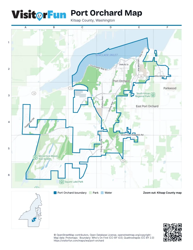
Street index of Port Orchard
Each street on the sheet and the grid squares it crosses.
- Arnold Avenue EastE1
- Bay StreetE1, D2, E2
- Chester StreetE1
- Decatur AvenueE1, E2
- Farragut Avenue NorthE1, E2
- Lawrence StreetE1
- Mahan StreetE1
- Perry Avenue NorthE1, E2
- Tracy Avenue NorthE1, E2
- Beach Drive EastF1
- East Illinois StreetF1
- East Washington StreetF1
- Olney Avenue EastF1, F2
- Southwest Bay StreetC2, D2, C3
- Ada StreetD2, E2
- Austin AvenueD2
- Bank StreetD2
- Baycrest CourtD2
- Caseco LaneD2
- Cline AvenueD2
- Dekalb StreetD2, E2
- Division StreetD2, E2
- Dogwood Hill Road SouthwestD2
- Dwight StreetD2, E2
- Eaglecrest PlaceD2, D3
- Frederick AvenueD2
- Garrison AvenueD2, D3
- Givens StreetD2
- Grant AvenueD2
- Heron Ridge AvenueD2, D3
- High StreetD2
- Hill AvenueD2, D3
- Hull AvenueD2
- Kendall StreetD2, E2
- Kitsap StreetD2, E2
- Landover PlaceD2, D3
- Orchard AvenueD2
- Port Orchard BoulevardD2, D3
- Port StreetD2
- Portland AvenueD2, D3
- Prospect StreetD2, E2
- Scotland CourtD2
- Sherman AvenueD2, D3, D4
- Short AvenueD2
- Sidney AvenueD2, D3, D4
- Sidney ParkwayD2
- Smalley LaneD2, E2
- Smith StreetD2
- Southeast Kinsley LaneD2, E2
- Southwest Wilkins DriveD2
- Spokane AvenueD2, D3
- Sroufe StreetD2, E2
- Sweany StreetD2
- Sweeney StreetD2
- Tacoma AvenueD2, D3
- Taylor StreetD2, E2
- Wales CourtD2
- Water Street Boat LaunchD2
- West AvenueD2, D3, D4
- Wilkins Place SouthwestD2
- Annies PlaceE2
- Bethel AvenueE2, E3
- Coles LaneE2
- East 4th StreetE2
- Farragut AvenueE2
- Guy Wetzel RoadE2
- Guy Wetzel StreetE2
- Harrison AvenueE2
- Karcher Road SoutheastE2
- Lincoln Avenue SoutheastE2
- Maple AvenueE2
- Maple Avenue EastE2
- Mile Hill DriveE2, F2
- Mitchell AvenueE2, E3
- Morton StreetE2
- Park Avenue EastE2
- Plisko LaneE2
- Redwood DriveE2
- Retsil Road EastE2
- Retsil Road SoutheastE2
- Rockwell AvenueE2
- Seattle AvenueE2
- Sk Malll Access RoadE2
- Southeast Mile Hill DriveE2, F2
- Southeast Taylor StreetE2
- Stockton StreetE2
- Sutton LaneE2
- Tracy AvenueE2
- Wolves RoadE2
- Courage Court SoutheastF2
- Freedom Court SoutheastF2
- Glenmore LoopF2
- Harrison Avenue SoutheastF2
- Henry Hanson Road SoutheastF2
- Higgins Road SoutheastF2
- Huntington StreetF2
- Jackson Avenue SoutheastF2
- Kidd Avenue SoutheastF2
- Lowren StreetF2
- Olney Avenue SoutheastF2
- Orlando StreetF2
- Payseno Lane SoutheastF2
- Roosevelt Avenue SoutheastF2
- Southeast Horstman RoadF2
- Southeast Lovell StreetF2
- Southeast Orlando StreetF2
- Sprague StreetF2
- Tufts Avenue EastF2
- Wendell Avenue SoutheastF2
- Whittier Avenue SoutheastF2
- Advantage AvenueC3, D3
- Canyon CourtC3
- Cedar Canyon PlaceC3
- Cedar Ridge CourtC3
- Lloyd ParkwayC3
- Longview AvenueC3
- Lumsden RoadC3
- Ross StreetC3, D3
- Shawn Road SouthwestC3
- Snowridge AvenueC3, D3
- South Kitsap BoulevardC3, D3
- Southwest Cook RoadC3
- Southwest Old Clifton RoadC3, A4, B4, C4
- State Highway 16C3, D5
- Tremont Street WestC3, D3
- Vivian CourtC3
- Atlas ApartmentsD3
- Becky AvenueD3, D4
- Bill AvenueD3
- Blackstone CourtD3
- Bothwell StreetD3
- Canyon LaneD3
- Clay LaneD3
- Doc Minor LaneD3
- Donna StreetD3
- Flower AvenueD3
- Forest Park StreetD3
- Golden Pond StreetD3
- Guthrie StreetD3
- Howard AvenueD3
- Jones DriveD3
- Lippert Drive WestD3
- Lund StreetD3
- Maltese CourtD3
- May Street WestD3
- Melcher StreetD3
- Melcher Street WestD3
- Poplar StreetD3
- Pottery AvenueD3, D4
- Radey StreetD3
- Roland AvenueD3
- Sage CourtD3
- Sage StreetD3
- South StreetD3
- South Street WestD3
- Southeast Lund AvenueD3
- Starlet LaneD3
- Sunset Lane WestD3
- Tremont PlaceD3
- Tremont StreetD3
- West Lippert DriveD3
- Harold Drive SoutheastE3
- Higher Ground LaneE3
- Mitchell Road SoutheastE3
- Bittern LaneA4, B4
- Chatterton Southwest AvenueA4
- Currant Lane SouthwestA4
- Explorer AvenueA4, B4
- Feigley Road SouthwestA4
- Feigly Road SouthwestA4
- Hibiscus Circle SouthwestA4
- Landis Southwest CourtA4
- Lone Bear Lane SouthwestA4
- McCormic Village DriveA4, B4
- Novak Southwest DriveA4
- Our Place SouthwestA4
- Pickford Place SouthwestA4
- Reef Road SouthwestA4, B4
- Southwest Anchorage LaneA4, B4
- Southwest Colbert WayA4
- Southwest Mooring LaneA4, B4
- Southwest Stanwick WayA4
- Southwest Yarrow StreetA4, B4
- Wandering WayA4, B4
- Adare Street SouthwestB4, C4
- Amherst Way SouthwestB4, B5
- Anderson Hill Road SouthwestB4
- Bantry bay Loop SouthwestB4, C4
- Brody Lane SouthwestB4
- Chanting Circle SouthwestB4
- Kinsale Place SouthwestB4, C4
- McCormick Woods Drive SouthwestB4, A5, B5, C5, A6, B6, C6
- Murrelet Avenue SouthwestB4
- Riflebird Place SouthwestB4
- Sail Lane SouthwestB4
- Shelbourne Place SouthwestB4, C5
- Southwest Berwick PlaceB4
- Southwest Chowchilla WayB4
- Southwest Egret StreetB4
- Southwest Fantail PlaceB4
- Southwest Fiscal StreetB4
- Southwest Grebe WayB4
- Southwest Jabririn WayB4
- Southwest Lazuli StreetB4
- Southwest Pier LaneB4
- Southwest Rutherford CircleB4
- Southwest Saint Andrews DriveB4, B5
- Southwest Siskin CircleB4
- Southwest Swift AvenueB4
- Southwest Warbler WayB4
- Southwest Wigeon AvenueB4
- Strathmore Circle SouthwestB4
- Bundoran Place SouthwestC4
- Coolrain Place SouthwestC4, C5
- Hibernia Avenue SouthwestC4, C5
- Rory Avenue SouthwestC4
- Abigail WayD4
- Alpha LaneD4
- Anderson AvenueD4
- Caleb Place SoutheastD4
- Campbell LaneD4
- Carnation CourtD4
- Dallas StreetD4
- Echo CourtD4
- Fernwood LaneD4
- Fireweed StreetD4
- Flower Meadows StreetD4
- Fox Glove CourtD4
- Garden DriveD4
- Gazebo StreetD4
- Geiger Road SoutheastD4, D5
- Glenwood Road SouthwestD4, C5, C6
- Goldenrod StreetD4
- Granat StreetD4
- Indigo Pointe PlaceD4
- Leora Park StreetD4
- Shamrock LaneD4
- Sidney LaneD4
- Sidney Road SouthwestD4, D5
- South Flower AvenueD4
- Southeast Moorea LaneD4
- Southeast Sedgwick RoadD4, E4, D5
- Southwest Berry Lake RoadD4
- Southwest Birch RoadD4
- Southwest Macia LaneD4
- State Highway 16 SouthwestD4, D5
- Stetson LaneD4
- Bethel Road SoutheastE4, E5
- Ramsey Road SoutheastE4
- Southeast Piperberry WayE4
- Troon Avenue SouthwestA5, B5
- Troon Place SouthwestA5, B5
- Donnegal Circle SouthwestB5
- Gleneagle Avenue SouthwestB5, A6, B6
- Hawkstone Avenue SouthwestB5, B6
- Marymac Drive SouthwestB5
- Muirkirk Lane SouthwestB5
- Prestwick Lane SouthwestB5, B6
- Roxburghe Place SouthwestB5
- Southwest Dunraven PlaceB5, B6
- Southwest Kenmore CourtB5
- Tobermory Circle SouthweastB5
- Tobermory Circle SouthwestB5
- Turnberry Place SouthwestB5
- Vardon Circle SouthwestB5
- Addisson Road SouthwestC5
- Dunmore Lane SouthwestC5
- Ladd Court SouthwestC5
- Mansfield Court SouthwestC5, D5
- Southwest Fielder PlaceC5
- Southwest Pendelton WayC5
- Southwest Rebel WayC5
- Southwest Sedge StreetC5
- Southwest Sedgwick RoadC5, D5
- Wavery Road SouthwestC5
- Bravo TerraceD5
- Dogwood Road SoutheastD5
- Ferate Avenue SoutheastD5
- Sedgwick Loop SouthwestD5
- Southeast Cedar RoadD5
- Southeast Meline RoadD5
- Southwest Hayworth DriveD5
- Southwest Hovde RoadD5
- Kenfig Place SouthwestA6
- Southwest Galway CourtA6
- Telford Way SouthwestA6
- Wentworth Avenue SouthwestA6, B6
- Wexford Avenue SouthwestA6, B6
- Ashridge Avenue SouthwestB6
- Baltray Place SouthwestB6
- Broadstone Place SouthwestB6
- Kells Lane SouthwestB6
- Killeen Place SouthwestB6
- Parkstone Lane SouthwestB6
- Southwest Dundee CourtB6
- Southwest Tenby CourtB6
- Southwest Depot CourtC6
- Southwest Lider RoadC6
- Southwest Station CircleC6
Places on the map
- 1 Stop Plaza
- Albertsons
- Bethel Centre
- Blue Goose Tavern
- C&M Short Stop
- Capital Christian Center
- Cedar Heights Junior High School
- Chester's
- City of Port Orchard City Hall
- Comfort Inn On the Bay
- Curch of the Nazarene
- Deer Park
- DQ Grill & Chill
- EPPEL Family Medicine
- Fred Meyer
- Givens Playfield
- High Point Shopping Center
- Kitsap Marina
- Lowe's
- McCormick Village Park
- McCormick Woods Golf Club
- McCormick Woods Trail System
- Mile Hill Plaza
- North Lake
- Port Orchard Marina
- Port Orchard Railway Marina
- Port Orchard Yacht Club
- Sidney Glen Elementary School
- Sinclair Inlet
- Sinclair Inlet Marina
- South Kitsap High School
- Suldan's Boat Works
- Sunset Lane Cemetery
- Towne Square Mall
- Van Zee Park
- Veterans Cemetery
- Veterans Memorial Park
- Westbay Center
- Yachtfish Marine
Next to Port Orchard
- East Port Orchard
- Parkwood
© OpenStreetMap contributors, Open Database License, openstreetmap.org/copyright · Map data: Protomaps · Boundary: Who's On First (CC-BY 4.0); Quattroshapes (CC BY 2.0)















