

Washington map
Skamania County map
About 12,660 people live here (Census Bureau, 2024 estimate). The sheet's index lists 300 streets; Lewis River Road, Wind River Road and Forest Road 23 cross the most grid squares. Things to do inside the boundary: Mount St. Helens National Volcanic Monument, Beacon Rock State Park and Cedar Creek Alpacas.
Open the map (PDF, US Letter)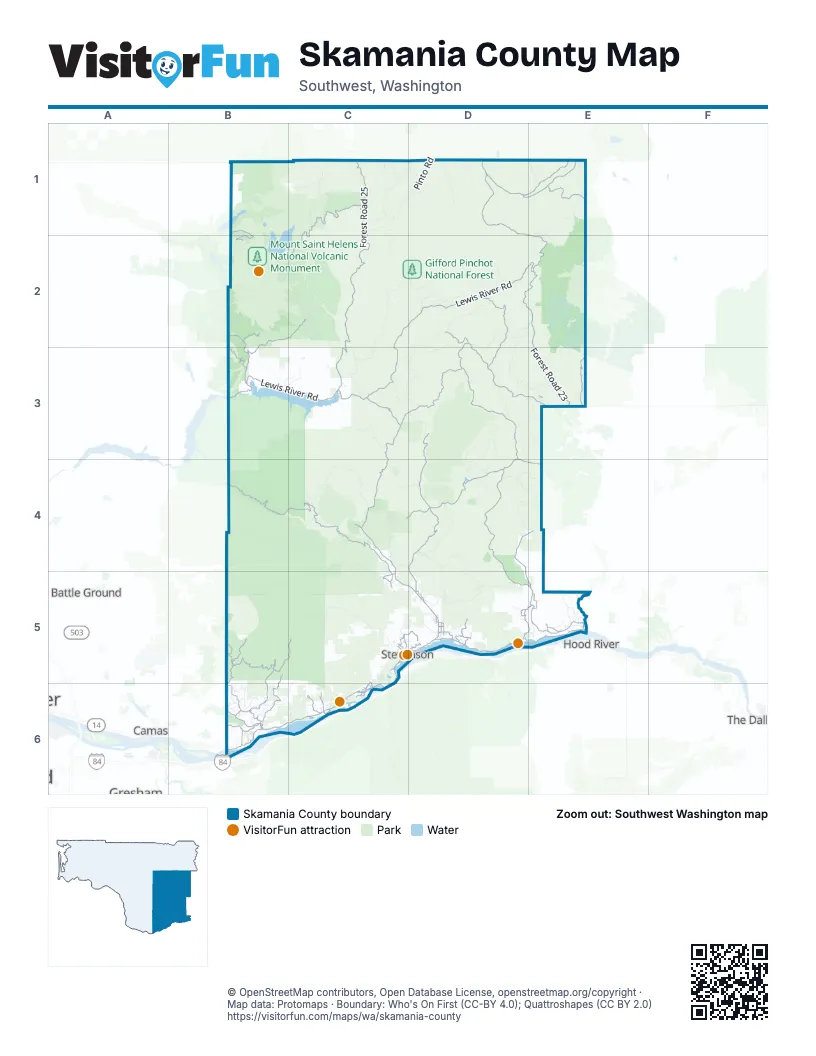
Street index of Skamania County
Each street on the sheet and the grid squares it crosses.
- Evergreen HighwayC5, B6, C6
- Lewis and Clark Trail HighwayD5, E5
- 2nd StreetC5, D5, C6
- 1st StreetC5, D5, C6
- Lewis and Clark HighwayE5
- Bridge of the GodsC5
- Southeast Lewis and Clark HighwayB6
- Lewis River RoadC2, D2, E2, B3, C3
- Wind River RoadC3, D3, C4, C5, D5
- Forest Road 25C1, C2, C3
- Washougal River RoadB5, C5, B6
- Spirit Lake HighwayB1, B2
- Curly Creek RoadC3
- Canyon Creek RoadB6
- Salmon Falls RoadB6
- Hot Springs AvenueC5, D5, C6
- Randle-Lewis River RoadC3
- Southeast Washougal River RoadB6
- Forest Road 23D1, E1, D2, E2, E3
- Bare Mountain RoadB4, C4
- Forest Road 88D2, D3, E3
- Forest Road 24D2, D3, D4, E4
- Forest Road 65D3, D4, D5
- Forest Road 66D4, D5, E5
- Forest Road 99C1, B2, C2
- Carson Guler RoadD3, C4, D4
- Cook-Underwood RoadD5, E5
- W-1200 RoadB5
- Forest Road 21D1, E1
- Lava Canyon RoadB2, C2, B3
- Forest Road 30D3
- Mabee Mines RoadB5, B6
- Forest Road 56D1, E1
- Loop RoadC5, D5
- Forest Road 8851D2, D3
- Skamania Mines RoadB5, B6
- Forest Road 5603E1
- Oklahoma RoadD4, D5, E5
- Forest Road 8303B3
- Forest Road 8040E3
- Cascade DriveC6
- Skye RoadB6
- Berge RoadD5
- Szydlo RoadC4, C5
- Willard RoadE5
- Merrill Lake RoadB2, B3
- Belle Center RoadB6
- Duncan Creek RoadC6
- Climber's Bivouac RoadB2
- Forest Road 18D4, E4
- Woodard Creek RoadC6
- Forest Road 80E3
- Metzger RoadD5
- Mount Pleasant RoadB6
- Hemlock RoadC5, B6
- Old State RoadD5
- Kanaka Creek RoadC5, D5
- Wind Mountain RoadD5
- Kollock-Knapp RoadE5
- Jessup RoadD5
- Smith-Beckon RoadD5
- Trout Creek RoadC5
- Southwest Rock Creek DriveC5
- Maple Way RoadC5
- Skamania Landing RoadC6
- Forest Road 83C2
- Evergreen DriveC6
- Panther Creek RoadD5
- Martha Creek RoadC5
- Ausplund RoadE5
- Northeast 412th AvenueB5, B6
- Mineral Springs RoadC4
- Garrison DriveC6
- Home Valley Cut-Off RoadD5
- Vancouver AvenueC5, D5
- Cooper AvenueE5
- Shipherd Falls RoadD5
- Northwest Gropper RoadC5
- School StreetC5
- Northwest Kanaka Creek RoadC5, D5
- Trout Lake Creek RoadE3
- Leavens StreetC5, D5
- Northwest Chesser RoadC5
- Northeast Frank Johns RoadD5
- Hot Springs Alameda RoadC5
- Southwest Russell AvenueC5
- Cooper Avenue SpurE5
- Columbia StreetD5
- Rock Creek DriveC5
- Hot Springs WayC6
- Walnut LaneC6
- Forest Road 68D4, D5
- Forest Road 42B4, C4
- Forest Road 32D2, C3, D3
- Forest Road 2329E1, E2
- Forest Road 8810D2, E2, D3, E3
- Spencer RoadC2, D2
- Forest Road 77C1, D1
- Forest Road 93C2, C3
- Forest Road 37B4, C4
- Forest Road 41B4, B5, C5
- Forest Road 53B4
- Forest Road 58C4
- Forest Road 43C4, C5
- Forest Road 86D4, E4
- Forest Road 26C1
- Mouse Creek RoadD4
- Forest Road 60C4
- Forest Road 6035D3, D4
- Snyder Pasture RoadC1, C2
- Forest Road 6808D5
- Forest Road 28C1, D1
- Forest Road 3211C3, D3
- Pepper Creek RoadC3
- Pinto RoadD1
- Forest Road 9085D2
- W-2000 RoadC5
- Forest Road 3230D2, D3
- Forest Road 31C3
- Little Buck Creek RoadE5
- Forest Road 6020D3, D4
- N935 Quartz Creek RoadD2
- Forest Road 8854D2, D3
- Forest Road 29D1
- CG-2000C5
- W-1400 RoadC5, C6
- W-1490 RoadC5
- Flat Top RoadD3, E3
- East Crater RoadD3, D4
- Forest Road 8620D4, E4
- CG-2000 RoadC5
- Outlaw RoadD3
- Forest Road 5704B4, C4
- Forest Road 78D1, E1
- Forest Road 8831D3
- Forest Road 3220C3, D3
- Forest Road 57B4
- Bear Creek RoadD5
- Forest Road 8631D4, E4
- South Forlorn Lakes RoadD4
- Gumboot Mountain RoadB4
- North Fork RoadB5, B6
- Forest Road 34C4
- Little Soda Springs RoadC4
- Peterson Ridge RoadD3, E3, E4
- Forest Road 8860D2, E2
- Forest Road 2515C1
- Dry Creek RoadC4
- Road 30B3, C3
- Forest Road 64C4
- Forest Road 5407C4
- Forest Road 67C4, D4
- Carson Creek RoadD5
- Forest Road 2612C1
- Silverstar RoadB5
- Haystack Butte RoadE3
- Labarre RoadB6
- McCloskey Creek RoadB6, C6
- Lacock-Kelchner RoadE5
- Kidney Lake RoadC5, C6
- Placid Lake RoadD3
- Kueffler RoadC6
- Lower Jackpine RoadC3
- Cedar Falls RoadB6
- State Forest RoadB5
- Forest Road 3062C4
- Chenowith RoadE5
- Ash Lake RoadC5
- Warren Gap RoadC4, D4
- Smith-Cripe RoadC6
- Flattop Viewpoint RoadE3
- Ryan-Allen RoadC5
- Blackledge RoadC5
- Skaar RoadC5
- Buhman RoadB6
- Forest Road 6621D4
- Mathews RoadB6
- Lakeview RoadC5, E5
- Wantland RoadB6
- Kellett RoadB6
- Horseshoe Lake Campground RoadE1
- Road 9015B3, C3
- Franz RoadC6
- Riverside DriveB6
- Forest Road 2400-041D4
- Road 7906B3
- Blue Lake RoadC5
- Forest Road 3000-580D3
- Cape Horn RoadB6
- W-2030 RoadB5, C5
- CG-1400 RoadC5
- Orchard LaneE5
- Downham RoadC5
- Forest Road 3065C4
- Forest Road 2334E2
- Forest Road 2904D1
- Dam Access RoadC6
- Forest Road 5601E1
- Aalvik RoadC5
- Kwneesum RoadB5
- Comcomly Lake RoadD3
- Scoggins RoadE5
- Forest Road 2329-022E1
- Marble RoadB6
- Little Rock Creek RoadD5
- Snag Mountain RoadB5
- Archer Mountain RoadC6
- Girl Scout RoadD5
- School House RoadE5
- Dimrill Dale RoadC6
- High Bridge RoadD5
- Dale RoadB6
- Wildlife DriveB6
- Frank RoadE3
- Sneider-Barks RoadB6, C6
- Forest Road 2608C1
- Scott RoadC6
- Butler Loop RoadC6
- Ryan Travelli RoadB6
- Cold Springs Indian Campground RoadD3
- Marrin-Didier RoadB6
- Forest Road 8031-120E2
- Indian Mary RoadC6
- Love RoadE5
- Foster RoadC5
- Forest Road 4109B5
- Oregon View RoadB6
- Krogstad RoadB6
- Forest Road 5701B4
- Guptil RoadC6
- Forlorn Lakes RoadD4
- Indian Cabin RoadD5
- Panda RoadB6
- Kelly-Henke RoadD5
- Dobbins RoadB6
- Thuja Narrows RoadB6
- Upper Lakeview RoadE5
- Loowit LaneC3
- Nelson Creek RoadD5
- Stewart RoadC5
- Wauna Lake RoadC5, C6
- Trout Lake Creek Campground RoadE3
- Spring Creek Hatchery RoadE5
- Lower Lake DriveC3
- Old Detour RoadD5
- Strawberry LoopC6
- Mount Rainier DriveC3
- Bergen RoadD5
- No 10 RoadC3
- White Dog RoadB6
- Tillicum RoadD3
- Brooks RoadD5
- Carleton RoadB6
- River RoadB6
- Forest Road 8031E3
- Leete RoadC4
- Southwest Cascade AvenueC5, D5
- Forest Road 8020E3
- Bunker Keys RoadD5
- Peterson Prairie Campground LoopD4
- Wess RoadE5
- Kramer RoadE5
- Uran RoadB6
- Strunk RoadB6
- Boulder Ridge DriveD5
- Forest Road 8620-070D4
- Elk Run RoadC6
- Turk RoadB6
- Spring Creek Campground RoadE1
- Skelton RoadC6
- West Beacon Highlands RoadC6
- Campground RoadC3
- Carson Depot RoadD5
- Jemtegaard RoadB6
- Doetsch Ranch RoadC6
- Tote RoadB6
- Miller RoadB6
- Fitzgerald RoadB6
- Columbia DriveD5
- Cultus Creek Camp RoadD3
- Hoffman RoadB6
- Pacific RoadC6
- Elizabeth WayB6
- Home Valley Park RoadD5
- Highland Orchards RoadE5
- Frank Johns RoadC5, D5
- Iman Cemetery RoadC5
- Cannavina RoadC4
- Farnsworth RoadC6
- Cedar Creek RoadD5
- Cedar Fork LaneB6
- Shelly LaneC6
- Newell RoadE5
- Newquist RoadB6
- Upland RoadB6
- Hudson RoadB6
- Harder RoadB6
- Saint Martin's Hill RoadD5
- Forest Road 3062-057C4
- Highland RoadB6
Things to do on the Skamania County map
Places on the map
- Ape Cave
- Ape Glacier
- Ashes Lake
- Basin Lakes
- Beacon Rock State Park
- Big Lava Bed
- Blue Lake Campsites
- Bonneville Lock and Dam
- Bowles Lakes
- Carson
- Cayuse Meadow
- Coldwater Lake
- Columbia Falls Natural Area Preserve
- Council Lake
- Crater Glacier
- Drano Lake
- Forlorn Lakes
- Fort Cascades Trail
- Gifford Pinchot National Forest
- Goose Lake
- Grand Meadows
- Greenleaf Slough
- Indian Heaven Wilderness
- Lava Canyon
- Lone Butte Meadows
- McClellan Meadows
- Mosley Lakes
- Mount Adams Wilderness
- Mount Saint Helens National Volcanic Monument
- Muddy Meadows
- Nelson Glacier
- North Bonneville
- North Shore Recreation Area
- Pierce Island
- Pinnacle Glacier
- Rock Cove
- Saint Helens Lake
- Shoestring Glacier
- Skamania Lodge Golf Course
- Trapper Creek Wilderness
Next to Skamania County
- Battle Ground map
- Camas map
- Gresham
- Hood River
- The Dalles
- Washougal map
© OpenStreetMap contributors, Open Database License, openstreetmap.org/copyright · Map data: Protomaps · Boundary: Who's On First (CC-BY 4.0); Quattroshapes (CC BY 2.0)















