

Washington map
Tukwila map
About 21,636 people live here (Census Bureau, 2024 estimate). The sheet's index lists 235 streets; Interurban Avenue South, 43rd Place South and 46th Avenue South cross the most grid squares. Things to do inside the boundary: Museum of Flight and Westfield Southcenter.
Open the map (PDF, US Letter)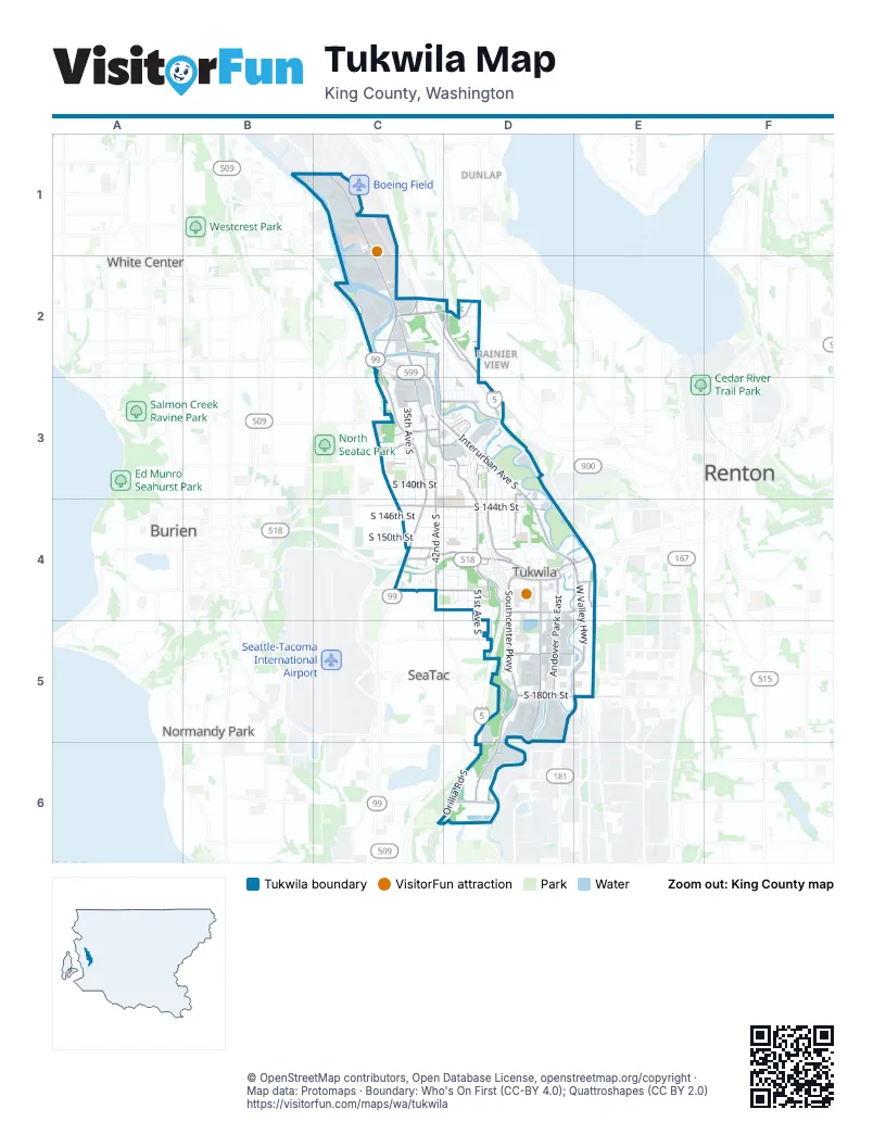
Street index of Tukwila
Each street on the sheet and the grid squares it crosses.
- 16th Avenue SouthB1
- Airport Way SouthC1, C2
- East Marginal Way SouthC1, C2, C3
- Museum of Flight Place SouthC1, C2
- Perimeter Road SouthC1
- South 81st PlaceC1
- South 87th PlaceC1
- South 94th PlaceC1, C2
- 27th Avenue SouthC2
- 35th Lane SouthC2
- 39th Avenue SouthC2
- 40th Avenue SouthC2, C3, C4
- 40th Place SouthC2, C4
- 41st Avenue SouthC2, C3, C4
- 42nd Avenue SouthC2, C3, C4
- Boeing Access RoadC2, D2
- Interurban Avenue SouthC2, C3, D3, D4, E4
- Interurban Place SouthC2, C3
- South 102nd StreetC2
- South 104th PlaceC2, D2
- South 104th StreetC2
- South 112th StreetC2, D2
- South 113th StreetC2
- South 114th StreetC2, D2
- South 115th StreetC2
- South 116th StreetC2, D2
- South 116th WayC2
- South 117th PlaceC2
- South 117th StreetC2
- South 119th StreetC2
- South 96th PlaceC2
- South Norfolk StreetC2
- Tukwila International BoulevardC2, C3, C4
- West Marginal Place SouthC2
- West Marginal Way SouthC2
- 43rd Place SouthD2, C3, C4, D4
- 44th Avenue SouthD2, D3, D4
- 44th Place SouthD2, D3, D4
- 46th Avenue SouthD2, D3, D4, D6
- 47th Avenue SouthD2, D3, D4
- 48th Avenue SouthD2, D3, D4
- 49th Avenue SouthD2, D3, D4
- 50th Avenue SouthD2, D3
- 50th South AvenueD2
- 51st Avenue SouthD2, D3, D4
- Beacon Avenue SouthD2
- Martin Luther King Junior Way SouthD2, D3
- South 107th StreetD2
- South 109th CourtD2
- South 109th StreetD2
- South 111th StreetD2
- South 118th StreetD2
- South Augusta StreetD2
- South Avon StreetD2
- South Hazel StreetD2
- South Ryan WayD2
- South Wallace StreetD2
- 30th Place SouthC3
- 31st Avenue SouthC3
- 32nd Avenue SouthC3
- 33rd Avenue SouthC3
- 33rd Place SouthC3
- 34th Avenue SouthC3, C4
- 34th Place SouthC3
- 35th Avenue SouthC3, C4
- 37th Avenue SouthC3, C4
- 38th Avenue SouthC3, C4
- 38th Lane SouthC3, C4
- 38th Place SouthC3, C4
- 43rd Avenue SouthC3, D3, C4
- Allentown BridgeC3
- Macadam Road SouthC3, D3, D4
- Military Road SouthC3, C4
- South 120th StreetC3
- South 122nd StreetC3, D3
- South 124th StreetC3, D3
- South 126th StreetC3
- South 128th StreetC3
- South 130th StreetC3
- South 131st PlaceC3, D3
- South 131st StreetC3
- South 132nd PlaceC3
- South 132nd StreetC3
- South 133rd StreetC3, D3
- South 134th StreetC3
- South 135th StreetC3
- South 136th StreetC3, D3
- South 137th PlaceC3
- South 137th StreetC3, D3
- South 138th StreetC3, D3
- South 139th StreetC3, D3
- South 140th StreetC3, D3
- South 141st StreetC3, D3
- South 142nd StreetC3, D3
- South 143rd StreetC3, D4
- 45th Avenue SouthD3, D4
- 45th Place SouthD3, D4
- 48th Place SouthD3, D4
- 50th Place SouthD3
- 51st Place SouthD3
- 52nd Avenue SouthD3, D4
- 52nd Place SouthD3
- 53rd Avenue SouthD3, D4, D5
- 54th Avenue SouthD3, D4, D5
- 55th Avenue SouthD3, D4
- 56th Avenue SouthD3, D4
- 56th Place SouthD3
- 57th Avenue SouthD3, D4, D5
- 58th Avenue SouthD3, D4
- 59th Avenue SouthD3, D4
- Beacon Coal Mine Road SouthD3
- Foster BridgeD3
- Gateway Drive SouthD3
- Maule AvenueD3
- South 122nd LaneD3
- South 125th StreetD3
- South 129th StreetD3
- South 130th PlaceD3
- South 134th PlaceD3
- South 141st PlaceD3
- South Pamela DriveD3
- 34th Lane SouthC4
- 37th Place SouthC4
- 38th Terrace SouthC4
- 39th Lane SouthC4
- 39th Place SouthC4
- 40th Lane SouthC4
- 41st Place SouthC4
- 42nd South AvenueC4
- International BoulevardC4
- Smile Dental Clinic Parking AisleC4
- South 142nd PlaceC4
- South 144th LaneC4
- South 144th StreetC4, D4
- South 146th StreetC4, D4
- South 148th StreetC4, D4
- South 150th StreetC4, D4
- South 151st StreetC4, D4
- South 152nd StreetC4, D4
- South 154th LaneC4
- South 154th StreetC4
- South 158th LaneC4
- South 158th StreetC4, D4
- South 159th LaneC4
- South 159th PlaceC4
- South 160th StreetC4, D4
- South 164th StreetC4, D4
- Southcenter BoulevardC4, D4, E4
- 44th Lane SouthD4
- 45th Lane SouthD4
- 46th Lane SouthD4
- 47th Place SouthD4
- 53rd Place SouthD4
- 54th Place SouthD4, D5
- 59th Place SouthD4
- 61st Avenue SouthD4
- 61st Place SouthD4
- 62nd Avenue SouthD4
- 63rd Place SouthD4
- 64th Avenue SouthD4
- 65th Avenue SouthD4
- 66th Avenue SouthD4
- Andover Park EastD4, D5
- Andover Park WestD4, D5
- Baker BoulevardD4
- Christensen RoadD4
- Evans Black DriveD4
- Fort Dent WayD4
- Klickitat DriveD4
- Maule Avenue SouthD4
- North Hill DriveD4
- Park Access RoadD4
- Slade WayD4
- South 143rd PlaceD4
- South 145th StreetD4
- South 147th StreetD4
- South 149th LaneD4
- South 149th PlaceD4
- South 149th StreetD4
- South 150th PlaceD4
- South 151st PlaceD4
- South 152nd PlaceD4
- South 153rd StreetD4
- South 156th StreetD4, E4
- South 159th StreetD4
- South 161st StreetD4
- South 162nd StreetD4
- South 163rd PlaceD4
- Southcenter ParkwayD4, D5, D6
- Southwest Grady WayD4, E4
- Starfire WayD4
- Strander BoulevardD4, E4
- Sunwood BoulevardD4
- Tukwila ParkwayD4
- Bullwinkle's Go-Kart TrackE4
- Longacres WayE4
- Nelson Place SouthE4
- Southwest 27th StreetE4
- Tukwila Station AccessE4
- West Valley HighwayE4, E5
- 68th Avenue SouthD5
- Cascade Avenue SouthD5
- Corporate Drive NorthD5
- Corporate Drive SouthD5
- Costco DriveD5
- Industry DriveD5
- Midland DriveD5
- Minkler BoulevardD5
- Olympic Avenue SouthD5
- Riverside DriveD5
- Segale Park Drive BD5
- Segale Park Drive CD5
- Segale Park Drive DD5
- South 166th StreetD5
- South 168th StreetD5
- South 170th StreetD5
- South 172nd LaneD5
- South 178th StreetD5
- South 180th StreetD5, E5
- South Glacier StreetD5
- South Todd BoulevardD5
- Sperry DriveD5
- Sperry Drive SouthD5
- Treck DriveD5
- Triland DriveD5
- Upland DriveD5
- Wig BoulevardD5
- 72nd Avenue SouthE5
- South 43rd StreetE5
- Orillia Road SouthC6, D6
- Frager Road SouthD6
- South 188th StreetD6
- South 196th StreetD6
- South 200th StreetD6
- South 204th StreetD6
Things to do on the Tukwila map
Places on the map
- Amazon DWA2
- Amazon SWA5
- Black River Yard
- Boeing Military Flight Center
- Cascade Behavioral Health
- Cascade View Elementary School
- Chinook Wind
- Codiga Park
- Costco
- Crestview Park
- Crystal Springs Park
- Duwamish Hill Preserve
- Duwamish River
- FAA Tower
- Fairway Center
- Floor & Decor
- Fort Dent Park and Athletic Center
- Foster Golf Links
- Foster High School
- Foster Memorial Park
- Gateway North
- Krafter's Land
- Lindal Corporate Park
- Museum of Flight
- N C Machinery
- Park Place Shopping Center
- Parkway Square Shopping Center
- Parkway Super Center
- Raisbeck Aviation High School
- Riverpoint Corporate Center
- Riverton Crest Cemetery
- Riverton Park
- South Seattle Intermodal Yard
- Southcenter Corporate Square
- Southcenter Plaza
- Southcenter Square
- Tukwila Commerce Park
- Tukwila Pond
- Westfield Southcenter
Next to Tukwila
- Burien map
- Dunlap
- NewHolly
- Normandy Park
- Othello
- Rainier View
- Renton map
- SeaTac map
- South Beacon Hill
- White Center
© OpenStreetMap contributors, Open Database License, openstreetmap.org/copyright · Map data: Protomaps · Boundary: Who's On First (CC-BY 4.0); Quattroshapes (CC BY 2.0)















