

Washington map
Tumwater map
About 27,826 people live here (Census Bureau, 2024 estimate). The sheet's index lists 300 streets; Capitol Boulevard South East, Capitol Boulevard South and Littlerock Road Southwest cross the most grid squares. Also on it: Black Lake Quarry LLC, Olympia Heliport and Pioneer Park.
Open the map (PDF, US Letter)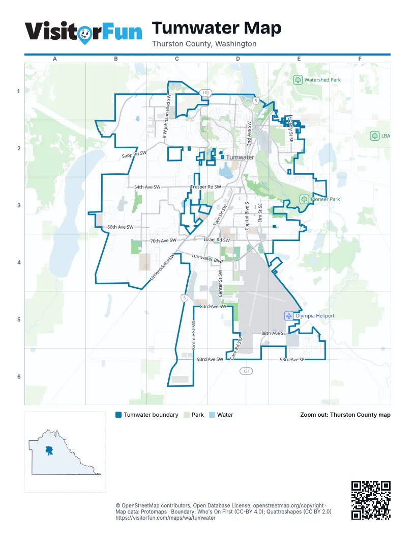
Street index of Tumwater
Each street on the sheet and the grid squares it crosses.
- Littlerock Road SouthwestC3, D3, B4, C4
- Trosper Road SouthwestC3, D3
- Tumwater BoulevardC4, D4
- Capitol Boulevard SouthD1, E1, D2, D3, D4
- Capitol Boulevard South EastD1, E1, D2, D3, D4, E4
- Crosby Boulevard SouthwestC1, D1, C2, D2
- Cleveland Avenue SoutheastE1, E2
- Old Highway 99 SoutheastE4, E5
- 93rd Avenue SouthwestC6, D6
- Tumwater Boulevard SouthwestD4
- Capitol Boulevard SoutheastD2, D4
- Deschutes WayD1, D2
- Boston Street SoutheastD2, D3
- Deschutes Way SouthwestD2
- Custer Way SouthwestD2
- E Street SouthwestD2
- Littlerock Road SoutheastC4
- Yelm Highway SoutheastE2
- North 2nd Avenue SouthwestD2
- Custer Way SoutheastD2, E2
- Tilley Road SouthwestD6
- Boston StreetD2
- Tyee Drive SouthwestD3, C4, D4
- Kirsop Road SouthwestB3, C3, B4
- Sapp Road SouthwestB2, C2
- Mottman Road SouthwestC1, D1
- Linderson Way SouthwestD3, D4
- Israel Road SouthwestC4, D4
- 2nd Avenue SouthwestD2, D3
- R W Johnson Boulevard SouthwestC1, C2
- 66th Avenue SouthwestB3, C3
- 93rd Avenue SoutheastD6, E6
- Miner Drive SouthwestC3, C4
- 70th Avenue SouthwestB4, C4
- Black Lake Boulevard SouthwestB1, B2
- Tumwater Boulevard SoutheastD4, E4
- Linwood Avenue SouthwestC2, D2
- Barnes Boulevard SouthwestC1, D1, D2
- Hoadly Street SoutheastE1, E2
- Center Street SouthwestD4, D5
- North Street SoutheastD2, E2
- Henderson Boulevard SoutheastE3, E4
- 6th Avenue SouthwestD2, D3, D4
- 88th Avenue SoutheastD5, E5
- 54th Avenue SouthwestB3, C3
- Bonniewood Drive SoutheastD3, D4
- Black Lake Belmore Road SouthwestB3
- New Market Street SouthwestD4
- 29th Avenue SouthwestB1, C1
- Somerset Hill Drive SouthwestC1
- Dennis Street SoutheastD3, E3
- Tilley Road SoutheastD5, E5, D6
- Irving Street SouthwestD1
- Ferguson Street SouthwestC1, C2
- Case Road SouthwestD5, D6
- Dennis Street SouthwestD3
- 83rd Avenue SouthwestC5, D5
- Elm Street SoutheastD3
- 7th Avenue SouthwestD2, D3
- North 7th Avenue SouthwestD1, D2
- 3rd Avenue SouthwestD2, D3
- Terminal Street SouthwestD4, D5
- Rural Road SouthwestC2, C3
- Armstrong Road SouthwestD5
- X Street SoutheastD3, E3
- 49th Avenue SouthwestB2
- South Street SoutheastE2
- 88th Avenue SouthwestC5, D5
- Deschutes Parkway SouthwestD1
- 32nd Avenue SouthwestC2
- Crites Street SouthwestC1, C2
- Harper Street SouthwestD4
- Trosper Street SouthwestB2, B3
- Bates Street SouthwestD2
- X Street SouthwestD3
- Israel Road SoutheastD4
- North 9th Avenue SouthwestD1
- Lee Street SouthwestD3
- North 3rd Avenue SouthwestD1, D2
- Lee Street SoutheastD3
- Middle Street SoutheastE2
- Deschutes Way SoutheastD1
- South 2nd Avenue SouthwestD2
- Kimmie Street SouthwestC4, C5, C6
- 76th Avenue SouthwestC4, D4, C5
- 73rd Avenue SouthwestC4, D4
- Vista Loop SouthwestD1, D2
- Silverspot Drive SoutheastE5, E6
- 78th Avenue SouthwestD4
- Lake Park Drive SouthwestD2, D3
- Ebbets Drive SouthwestD2
- Bush Mountain Drive SouthwestC2
- Mirasett Street SouthwestC4
- Ridgeview Loop SouthwestD2
- G Street SouthwestD2
- Vista Verde Lane SouthwestD2
- Commander Drive SouthwestC3
- 4th Avenue SouthwestD2
- Lambskin Street SouthwestC2, C3
- 91st Avenue SoutheastE5, E6
- Chapparel Drive SouthwestC2
- 53rd Loop SoutheastE3
- Cortez Loop SouthwestB3
- Antsen Street SouthwestC2
- Cavalier Loop SouthwestB4
- North 6th Avenue SouthwestD1, D2
- Bay Loop SouthwestD1
- T Street SoutheastD3, E3
- Z Street SoutheastD3, E3
- Delta Lane SoutheastE2
- Belmore Street SouthwestB3
- V Street SoutheastD3, E3
- Lorne Street SoutheastE1, E2
- Ferry Street SouthwestD1
- North 5th Avenue SouthwestD1, D2
- Palomino Drive SoutheastE2, E3
- Bush Mountain Court SouthwestC2
- Wyatt Loop SoutheastE5, E6
- Grant Street SouthwestD1
- Aster Street SoutheastE5, E6
- Schoth Street SouthwestC3
- Viola Street SoutheastE5, E6
- 12th Avenue SouthwestD1, D2
- 5th Avenue SouthwestD2
- Pat Kennedy Way SouthwestD5
- Hawthorne Street SoutheastE2
- Cavalier Street SouthwestB3, B4
- 37th Avenue SouthwestC2
- 73rd Avenue SoutheastD4, E4
- 89th Avenue SoutheastE5
- Pear Street SoutheastE2
- Bronington Drive SouthwestB4, C4
- Pifer Road SoutheastE2
- Gold Creek Drive SouthwestC3, C4
- M Street SoutheastD2
- Cassie Drive SouthwestC2
- Moore Street SoutheastE1
- W Street SoutheastD3
- Odegard Road SouthwestC3, D3
- 48th Avenue SouthwestC2
- Joppa Street SouthwestC2, C3
- C Street SouthwestD2
- Tradewinds Drive SoutheastE5
- Foster Drive SouthwestC3, C4
- H Street SouthwestD2
- Jody Court SouthwestB3
- Harvest Drive SoutheastE2, E3
- Vacation Drive SouthwestC3
- Shalom Drive SouthwestC3, C4
- Tartan Drive SouthwestD3
- Joppa Lane SouthwestC2
- Mimi Street SouthwestC3
- Tumwater Valley Drive SoutheastD2
- Restawhile Court SouthwestC3
- Hampton Drive SouthwestC1
- Kingswood Drive SoutheastD3
- 68th Avenue SouthwestB4
- 53rd Avenue SoutheastE3
- Lazy Street SouthwestC3, C4
- Tuscany Lane SouthwestC1
- 92nd Way SoutheastE6
- Klahowya Lane SouthwestC2
- Pioneer Street SouthwestD2
- Priscilla Drive SoutheastE5
- Hoadly Loop SoutheastE2
- Dowcor Lane SouthwestC6
- Kyodi Court SoutheastE3, E4
- Hartman Street SoutheastE2
- Southwick Court SouthwestC4
- Skyline Ridge Lane SouthwestD2
- 21st Avenue SouthwestC1
- Brittany Lane SouthwestC1, D1
- Fairybell Street SoutheastE6
- Dahlia Lane SouthwestD2
- Lively Street SouthwestC3, C4
- Woodland Drive SouthwestC2
- Sunflower Lane SouthwestD2
- Rock Creek Lane SouthwestD2
- Division Street SouthwestD2
- Firland Street SouthwestC1
- I Street SouthwestD2
- Tyndell Circle SouthwestC1
- Hansen Street SoutheastE2
- Surrey Trace Drive SoutheastE3
- Hayes Street SouthwestD1
- Maplewood Lane SoutheastE2
- Armstrong Avenue SoutheastE2
- Buttercup Street SoutheastE5
- Emerson Street SouthwestD1
- Simmons Heights Lane SouthwestC2
- Westbury Lane SouthwestC1
- North 4th Avenue SouthwestD1, D2
- Clark Street SouthwestD2
- Pinehurst Drive SoutheastD3
- Simmons Mill Court SouthwestC2
- Gardenia Lane SouthwestD1, D2
- Blackstone Drive SouthwestC2
- D Street SouthwestD2
- Gilbertson Lane SoutheastD3, E3
- Candytuft Drive SoutheastE6
- 80th Avenue SouthwestC5
- Hixon Drive SoutheastD3
- Fairfield Road SoutheastE1, E2
- Starlight Lane SouthwestC2, D2
- Coventry Lane SouthwestC1, D1
- Jenner Street SouthwestC4
- V Street SouthwestD3
- 56th Avenue SouthwestC3
- West Eagle Lane SouthwestC3
- Kirsop Village Drive SouthwestB3, B4
- Y Street SoutheastD3
- Bald Eagle Lane SouthwestC2, C3
- Cleanwater Drive SouthwestD4
- Golden Eagle Lane SouthwestC2, C3
- 68th Avenue SoutheastE3
- Select Court SoutheastE5
- 58th Lane SouthwestB3
- 8th Avenue SouthwestD2
- Fish Pond Creek Drive SouthwestB3
- Wyatt Court SoutheastE5
- Y Street SouthwestD3
- 68th Court SouthwestB4, C4
- Kimmie Loop SouthwestC5
- Suncrest 320 Israel RoadD4
- Fortner Drive SouthwestC1
- 65th Way SouthwestD3
- F Street SouthwestD2
- Jericho Lane SouthwestC3, C4
- 61st Court SouthwestB3
- Lido Court SouthwestB3
- Ruby Street SoutheastD3
- Cherry Lane SoutheastD3
- Rothenberg Drive SouthwestC4
- 68th Loop SoutheastE3
- Cougar Lane SouthwestB2, C2
- Quince Street SoutheastE2
- Banks Lane SouthwestD2
- 63rd Street SouthwestB3
- East Eagle Lane SouthwestC3
- 74th Avenue SouthwestC4, D4
- 67th Court SouthwestC3, B4
- Laurelhurst Drive SoutheastD3
- Honeysuckle Lane SouthwestD2
- Ridgeview Court SouthwestD1, D2
- Bishop Road SouthwestC3, D3
- Ferguson Lane SouthwestC2
- Lloyd Street SoutheastE2
- Almar Lane SoutheastE4
- Trosper Lake Street SouthwestC3
- Galenta Drive SouthwestC2
- Hazelhurst Drive SoutheastD3
- Windsor Lane SouthwestD1
- 65th Avenue SouthwestB3
- Viewpoint Court SouthwestD2
- Louise Street SouthwestC3
- Desoto Street SouthwestD2
- W Street SouthwestD3
- East Gray Sea Eagle Lane SouthwestC2, C3
- West Gray Sea Eagle Lane SouthwestC2, C3
- Friday Lane SouthwestD2
- Brech Street SoutheastE2
- Miller Street SouthwestD3
- Durell Road SoutheastE4
- Bates Street SoutheastD2, E2
- North South Street SoutheastE2
- Country Village Drive SouthwestC4
- Lady Slipper Street SoutheastE6
- White Hawk Lane SoutheastE3
- B Street SouthwestD2
- O Street SoutheastD3
- Prospector Place SouthwestC3
- Childress Court SouthwestC3
- Old Israel Road SouthwestC4
- Susitna Lane SouthwestD2
- 64th Lane SouthwestB3
- Tiger Lily Street SoutheastE6
- Ensley Lane SoutheastE2
- Tansy Street SoutheastE6
- 27th Avenue SouthwestC1
- Orchid Lane SouthwestD1
- Newport Court SouthwestB3
- Sunset Way SoutheastE1
- 47th Avenue SoutheastE2
- Lear Street SouthwestD6
- Primrose Lane SoutheastE2
- Dennis Court SoutheastD3
- T Street SouthwestD3
- Stratford Lane SouthwestD1
- Summerhill Court SouthwestC4
- Blass Avenue SoutheastE2
- Marshall Drive SoutheastE2
- Southglen Avenue SoutheastE2
- Bell Avenue SoutheastD3
- Lana Lane SouthwestD2, D3
- Lazy Court SouthwestC4
- Trosper Road SoutheastD3
- Farmside Lane SouthwestB4
- Wrigley Lane SouthwestD2
- Gerth Street SouthwestD3
- Gaston Lane SouthwestD4
Places on the map
- 7-Eleven
- A.G. West Black Hills High School
- Airlift Northwest
- Airport Golf
- All American Propane
- Barnes Lake
- Black Lake Elementary School
- Black Lake Quarry LLC
- Brewery Park at Tumwater Falls
- Capitol Lake
- Concrete Recyclers Inc.
- Costco
- Fred Meyer
- George Bush Middle School
- Interpretive Park
- Isabella Bush Park
- Linwood Avenue Detention Pond
- Masonic Memorial Park
- New Market Skills Center
- Odd Fellows Memorial Park
- Old Towne Plaza
- Olympia Heliport
- Olympic Memorial Garden Cemetery
- Pilot Travel Center
- Pioneer Park
- Rutledge Farm
- Southgate Shopping Center
- The Home Depot
- Town Center
- Tumwater Center
- Tumwater Craft District
- Tumwater High School
- Tumwater Hill Park
- Tumwater Historical Park
- Tumwater Middle School
- Tumwater Valley Golf Course
- United States Post Office
- Valley Athletic Center
- Walmart Supercenter
© OpenStreetMap contributors, Open Database License, openstreetmap.org/copyright · Map data: Protomaps · Boundary: Who's On First (CC-BY 4.0); Quattroshapes (CC BY 2.0)















