

Washington map
Vancouver map
About 198,992 people live here (Census Bureau, 2024 estimate). The sheet's index lists 300 streets; Southeast Lewis and Clark Highway, Northeast 18th Street and Southeast Evergreen Highway cross the most grid squares. Things to do inside the boundary: Fort Vancouver National Historic Site and The Historic Trust.
Open the map (PDF, US Letter)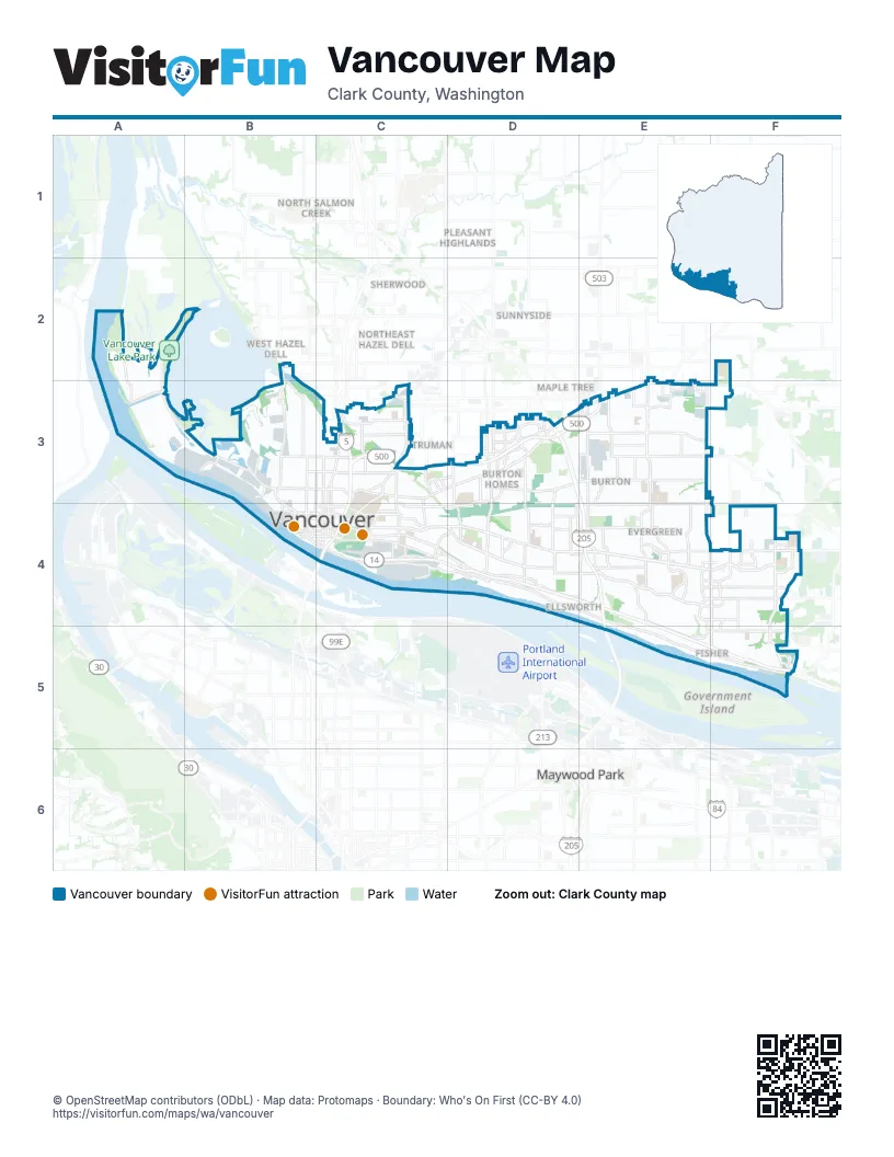
Street index of Vancouver
Each street on the sheet and the grid squares it crosses.
- Southeast Lewis and Clark HighwayC4, D4, E4, E5, F5
- Interstate BridgeC4
- Glenn L. Jackson Memorial BridgeE4, E5
- Falk RoadC3
- Southeast Marine Park WayC4
- Southeast Mill Plain BoulevardD4, E4, F4
- East Mill Plain BoulevardC4, D4
- Northeast Fourth Plain BoulevardD3, E3, F3
- Northeast 162nd AvenueE3, E4
- Southeast 192nd AvenueF4, F5
- Northeast 18th StreetD3, D4, E4, F4
- Southeast 164th AvenueF4, E5, F5
- Northeast 112th AvenueE3, E4
- Northeast Andresen RoadD3, D4
- North Andresen RoadD4
- Northeast 117th AvenueE3, E4
- Northeast 164th AvenueF3, E4, F4
- Northeast Gher RoadE3
- Northwest Lower River RoadA2, A3, B3
- Southeast 1st StreetE4, F4
- Southeast 34th StreetE5, F5
- Northeast 28th StreetD3, E3
- Northeast 137th AvenueE3, E4
- Northeast 49th StreetC3, E3
- East Fourth Plain BoulevardC3, D3
- Northeast 138th AvenueE3, E4
- West Mill Plain BoulevardB3, B4, C4
- Northeast Burton RoadD3, E3
- Main StreetC3, C4
- Grand BoulevardC3, C4
- Northeast 136th AvenueE3, E4
- Northeast Saint Johns RoadC3
- Columbia House BoulevardC4
- Northwest Fruit Valley RoadB2, B3
- West Fourth Plain BoulevardB3, C3
- Northeast Vancouver Mall DriveD3
- Washington StreetC3, C4
- East 33rd StreetC3
- Northeast Saint James RoadC3
- Northeast 87th AvenueD3, D4
- Northeast 86th AvenueD3, D4
- Southeast 10th StreetD4, E4, F4
- Northeast 13th StreetD4, E4, F4
- Southeast Ellsworth RoadE4
- Northeast 192nd AvenueF4
- Broadway StreetC3, C4
- East 39th StreetC3
- East 28th StreetC3
- Northeast Thurston WayD3
- East 15th StreetC4
- Northeast 25th StreetD3, E3
- C StreetC3, C4
- Northeast 15th AvenueC3
- Northeast Highway 99C3
- Saint Johns BoulevardC3
- South Lieser RoadD4
- Fruit Valley RoadB3
- Southeast Brady RoadF5
- Northeast Minnehaha StreetC3
- Southeast Chkalov DriveE4
- Northeast Chkalov DriveE4
- Northwest Lakeshore AvenueB2
- West 15th StreetC4
- North Lieser RoadD4
- Northeast Ward RoadE3
- Northwest Lake RoadF4
- Northeast Covington RoadE3
- Northeast Fourth Plain RoadF3
- Southeast Evergreen HighwayD4, E4, E5, F5
- Southeast McGillivray BoulevardE4, F4
- Southeast Columbia WayC4, D4
- Northeast 9th StreetD4, E4, F4
- MacArthur BoulevardD4
- East Evergreen BoulevardC4, D4
- Southeast 15th StreetD4, E4, F4
- Northeast 39th StreetC3, D3, E3
- Northeast 14th StreetD4, E4, F4
- Fort Vancouver WayC3, C4
- East 5th StreetC4
- Northeast 51st StreetC3, D3, E3
- East McLoughlin BoulevardC4
- Northeast 4th StreetD4, E4
- East 18th StreetD3, C4, D4
- Northeast 45th StreetC3, D3, E3
- Northeast 152nd AvenueE3, E4
- Columbia StreetC3, C4
- Northeast 7th StreetD4, E4
- Northeast 124th AvenueE3, E4
- Northeast 44th StreetC3, D3, E3
- Northeast 97th AvenueD3, D4
- Northeast 42nd StreetC3, D3, E3
- Southeast 20th StreetE4, F4
- Northeast 41st StreetC3, D3, E3
- Northeast 98th AvenueD3, D4
- Southeast Cascade Park DriveE4, E5, F5
- East 13th StreetC4
- Northeast 155th AvenueE3, E4
- Grant StreetB3, B4
- Northeast 47th StreetC3, D3, E3
- Northeast 121st AvenueE3, E4
- Southeast Village LoopE4, F4
- Northeast 151st AvenueE3, E4
- Northeast 59th StreetC3, E3
- Southeast 7th StreetD4, E4
- Southeast Blairmont DriveE4, E5
- Northeast 54th StreetC3, D3, E3
- Franklin StreetB3, C3, B4
- Northeast 147th AvenueE3, E4
- Northeast 92nd AvenueD3, D4
- East Reserve StreetC3, C4
- Northeast 11th StreetD4, E4, F4
- Southeast Park Crest AvenueE4
- Southeast 12th StreetD4, E4, F4
- Northeast 159th AvenueE3, E4
- Northeast 3rd StreetD4, E4, F4
- Northeast 143rd AvenueE3
- Northeast 139th AvenueE3, E4
- Northeast 53rd StreetC3, D3, E3
- Northeast 157th AvenueE3, E4
- Kauffman AvenueB3, B4
- Northwest Lincoln AvenueB3
- Northeast 131st AvenueE3, E4
- Southeast Olympia DriveE4
- Northeast 102nd AvenueD3, D4
- Northeast 156th AvenueE3, E4
- Southeast 176th AvenueF4, F5
- Northeast 104th AvenueD3, D4
- Southeast Westridge BoulevardF4
- Northeast 122nd AvenueE3, E4
- Northeast 65th StreetC3, E3, F3
- East 16th StreetC4
- Saint Helens AvenueD4
- Northeast 132nd AvenueE3, E4
- North Devine RoadD4
- West 39th StreetB3, C3
- Southeast 172nd AvenueF4, F5
- East 8th StreetC4
- Southeast Middle WayD4
- Southeast 168th AvenueF4, F5
- Southeast Talton AvenueE4
- Southeast 184th AvenueF4, F5
- Northwest Erwin O Rieger Memorial HighwayA2, A3
- Southeast 177th AvenueF4, F5
- Esther StreetC3, B4, C4
- Southeast 160th AvenueE4
- Northeast Four Seasons LaneE3, E4
- Northeast 109th AvenueE3, E4
- Thompson AvenueB3, B4
- Northeast 66th AvenueD3
- Northeast Stapleton RoadD3, D4
- Northeast 72nd AvenueD3
- Northwest Bernie DriveB2, B3
- North Garrison RoadD4
- Southeast 6th StreetD4, E4, F4
- Southeast 155th AvenueE4, E5
- Northeast Ross StreetC3
- East 6th StreetC4
- Northeast 48th StreetC3, E3
- Southeast 29th StreetE4, F4
- Southeast 136th AvenueE4
- Southeast French RoadD4, E4
- West 16th StreetB4, C4
- East 20th StreetC3, C4
- Southeast 104th AvenueD4
- West 8th StreetB4, C4
- South Andresen RoadD4
- Southeast Riverside DriveD4
- P StreetC3
- North Blandford DriveC4, D4
- Southeast Tech Center DriveF4
- Northeast 82nd AvenueD3, D4
- Northeast 94th AvenueD3, D4
- West 20th StreetB3, C3, B4
- Brandt RoadC3, C4
- Southeast 98th AvenueD4
- Southeast 121st AvenueE4
- Southeast 6th WayF4
- Northeast 65th AvenueD3, D4
- Northeast Hearthwood BoulevardE4
- West McLoughlin BoulevardB4, C4
- West 13th StreetB4, C4
- Northeast 40th StreetD3, E3, F3
- Northeast 77th AvenueD3
- Northeast Vancouver Plaza DriveD3
- Northeast 118th AvenueE3, E4
- Northeast 108th AvenueD3, E3, D4, E4
- Plomondon StreetC3, D3
- Northeast Vancouver Mall LoopD3
- Northeast 78th AvenueD3
- Northeast 184th AvenueF4
- Northwest Gateway AvenueB3
- Southeast 2nd StreetD4, E4, F4
- West Columbia WayB4, C4
- Southeast 105th AvenueD4
- North Morrison RoadD4
- Southeast 169th AvenueF4
- Columbia Ridge DriveD4
- West 33rd StreetB3, C3
- Port WayB4
- West Evergreen BoulevardB4, C4
- Northeast 107th AvenueD3, D4
- Northeast 63rd StreetE3, F3
- Southeast 148th AvenueE4, E5
- West 6th StreetB4, C4
- West 26th AvenueB3
- Northwest Whitney RoadB3
- Northeast 172nd AvenueF4
- Southeast 41st DriveF5
- Northeast 120th AvenueE3, E4
- Southeast 167th AvenueF4
- Southeast Columbia Palisades DriveF5
- Southeast Shorewood DriveD4
- Jefferson StreetB4
- Northwest Friberg-Strunk StreetF4
- Northwest Sluman RoadB2
- Southeast Columbia Shores BoulevardC4
- Southeast 162nd AvenueE4, E5
- Northeast Parkway DriveD3
- Northeast Coxley DriveD3, E3
- Northeast 114th AvenueE3
- Northeast Poplar StreetE3
- Northwest 32nd AvenueB3
- Grove StreetC4
- Northeast Countryside DriveE4
- Northeast 60th StreetC3, E3, F3
- Southeast 120th AvenueE4
- Northeast Auto Mall DriveD3
- Northeast 54th AvenueD3
- Northeast 179th AvenueF4
- Northeast Rosewood AvenueE3
- General Anderson AvenueC3
- Caples AvenueC3
- Sleret AvenueD4
- Mount Hood AvenueD4
- Southeast Hearthwood BoulevardE4
- Southeast Chelsea AvenueD4
- Northwest 61st StreetB3
- West 7th StreetB4, C4
- Northeast Hazel Dell AvenueC3
- Southeast 88th AvenueD4
- Mount Rainier DriveD4
- West 5th StreetB4, C4
- Southeast Bybee RoadF4
- South Morrison RoadD4
- Northwest 38th AvenueF4
- Phil Arnold WayC4
- South Garrison RoadD4
- Northeast LeRoy Haagen Memorial DriveE4
- Northeast 197th AvenueF4
- Northeast Crestwood DriveE4
- Southeast Tech Center PlaceF4
- Northeast 68th StreetC3
- South Blandford DriveC4
- Mount Whitney AvenueD4
- West 6th Street ConnectorB4
- Northwest Harborside DriveA3, B3, B4
- Northeast 16th StreetD4, E4, F4
- Southeast 5th StreetD4, E4, F4
- Northeast 34th StreetC3, D3, E3
- Northeast 5th StreetD4, E4, F4
- Northeast 15th StreetD4, E4, F4
- Northeast 20th StreetD3, E3, F3
- East 29th StreetC3
- Northwest Old Lower River RoadA3, B3
- Harney StreetB3, B4
- Northeast 46th StreetC3, D3, E3
- Northeast 129th AvenueE3, E4
- Southeast 19th StreetE4, F4
- East 32nd StreetC3
- Southeast 17th StreetD4, E4, F4
- Northeast 8th StreetD4, E4, F4
- Northeast 127th AvenueE3, E4
- Northeast 148th AvenueE3, E4
- Southeast 18th StreetE4, F4
- Daniels StreetC3, C4
- Northeast 31st StreetD3, E3
- Northeast 37th StreetD3, E3
- East 27th StreetC3
- Northeast 21st StreetD3, E3
- Southeast Briarwood DriveE4, E5
- Northeast 10th StreetD4, E4
- East 30th StreetC3
- Northeast 135th AvenueE3
- Northeast 145th AvenueE3, E4
- Northeast 160th AvenueE3, E4
- Northeast 36th StreetD3, E3
- Z StreetC3, C4
- F StreetC3, C4
- Northeast 12th StreetD4, E4
- Northeast 52nd StreetC3, D3, E3
- Northeast 26th StreetD3, E3
- Southeast Rivercrest DriveE4, E5
- Northeast 126th AvenueE3, E4
- Northeast 130th AvenueE3, E4
- Northwest Cherry StreetB3
- Northeast 22nd StreetD3, E3
- Idaho StreetC4, D4
- Northeast 32nd StreetD3, E3
- Southeast 35th StreetE5, F5
- Northeast 123rd AvenueE3, E4
Things to do on the Vancouver map
Places on the map
- Airport Green
- Arnada
- Bagley Downs
- Bella Vista
- Bennington
- Burnt Bridge Creek Greenway
- Burton Evergreen
- Burton Ridge
- Carter Park
- Cascade Highlands
- Cascade Southeast
- Central Park
- Columbia River
- Columbia Springs
- Columbia Tech Center
- Columbia Way
- Countryside Woods
- Dubois Park
- East Mill Plain
- Edgewood Park
- Ellsworth Springs
- English Pit
- Esther Short
- Evergreen Highlands
- Evergreen Shores
- Fairway Village Golf Course
- Fairway/164th
- Father Blanchet Park
- Fircrest
- First Place
- Fisher Quarry
- Fisher's Creek
- Fisher's Landing East
- Forest Ridge
- Fourth Plain Village
- Frenchman's Bar Park
- Fruit Valley
- Harney Heights
- Hearthwood
- Vancouver Lake Park
Next to Vancouver
- Andresen/Saint Johns
- Maple Tree
- Maywood Park
- North Salmon Creek
- Northeast Hazel Dell
- Pleasant Highlands
- Roads End
- Sherwood
- Sunnyside
- Truman
- West Hazel Dell
© OpenStreetMap contributors, Open Database License, openstreetmap.org/copyright · Map data: Protomaps · Boundary: Who's On First (CC-BY 4.0); Quattroshapes (CC BY 2.0)