

Wisconsin map
Franklin map
About 36,591 people live here (Census Bureau, 2024 estimate). The sheet's index lists 300 streets; West Loomis Road, South 76th Street and West Puetz Road cross the most grid squares. Also on it: Root River Parkway, Countryside Park and Emerald Park Landfill.
Open the map (PDF, US Letter)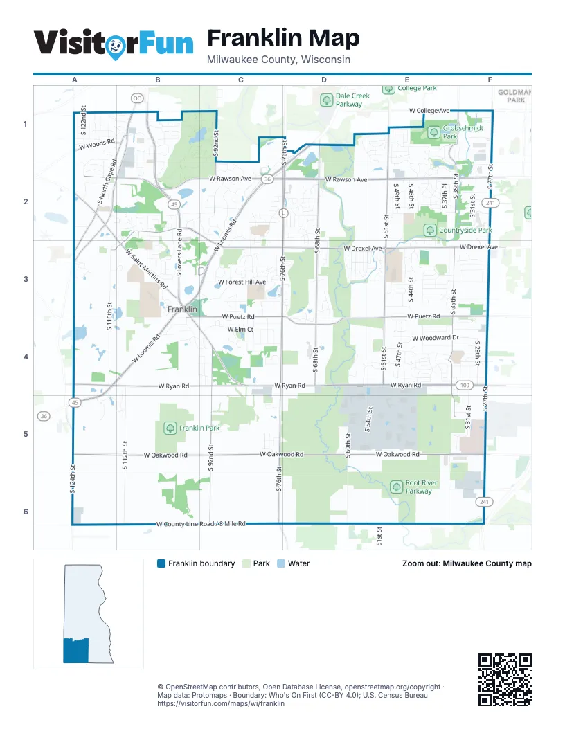
Street index of Franklin
Each street on the sheet and the grid squares it crosses.
- West Loomis RoadD1, C2, D2, B3, C3, A4, B4, A5
- West Ryan RoadA4, B4, C4, D4, E4, F4
- South 27th StreetF1, F2, F3, F4, F5, F6
- South Lovers Lane RoadB1, B2, B3
- West Saint Martins RoadA2, B3, B4, C4
- South North Cape RoadA1, B1, A2, A3, A5
- South 124th StreetA5, A6
- North Raynor AvenueA6
- Loomis RoadA5
- West Rawson AvenueA2, B2, C2, D2, E2, F2
- South 76th StreetD1, D2, C3, D3, C4, C5, C6
- West Forest Home AvenueB1, A2, B2, A3
- West College AvenueB1, C1, E1, F1
- North Cape RoadA3
- West Oakwood RoadA5, B5, C5, D5, E5, F5
- West Drexel AvenueB2, C2, C3, D3, E3, F3
- West Puetz RoadB3, C3, D3, E3, F3, D4, E4
- South 35th StreetF1, F2, F3, F4, F5
- South 51st StreetE1, E2, E3, E4
- South 92nd StreetC1, C2, C4, C5, C6
- South 68th StreetD1, D2, D3, D4
- West Church StreetB2, A3, B3
- West Woods RoadA1, B1
- West Elm RoadF6
- Ryan RoadA4
- County Highway UC6
- South 60th StreetD3, D4, D5, D6
- West Forest Hill AvenueC3, E3, F3
- South 116th StreetA1, A3, A4
- West County Line Road / 8 Mile RoadA6, B6, C6
- South 112th StreetB1, B4, B5, B6
- South 31st StreetF2, F3, F4, F5
- West South County Line Road / 8 Mile RoadD6, E6, F6
- South 47th StreetE1, E3, E4
- West Elm CourtB4, C4
- West Hilltop LaneC4, E4, F4
- South Franklin DriveE4, E5
- South 46th StreetE1, E2, E4
- West Woodward DriveE4, F4
- South 42nd StreetE3, E4
- West Minnesota AvenueE2, F2
- West Central AvenueE4, F4
- Northwestern Mutual WayF2, F3
- South 36th StreetF2, E3, F3, E4
- South 77th StreetC2, C3, C4
- West Beacon Hill DriveB3, C3, D3, E3
- West Franklin DriveD5, E5
- West Thorncrest DriveB4, C4, E4, F4
- West Acre AvenueE3, F3
- West Oakwood Park DriveD5, E5
- West Southland DriveE4, F4
- West Cascade DriveB3, C3, D3, E3
- West Southwood DriveE4, F4
- Imperial DriveC2, D2, C3
- South Chapel Hill DriveB2, B3
- South 54th StreetE4, E5
- South Mission DriveB2, B3
- West Briarwood DriveB4, C4, F4
- South Cambridge DriveC2
- South 83rd StreetC2, C3, C4
- South Oakwood Park DriveE4, E5
- South Deerwood LaneB3
- South 58th StreetD3, D4, D5
- South 43rd StreetE3, E4
- South 50th StreetE1, E2
- South 34th StreetF1, F3, F5
- West Bel Mar DriveA1, B1
- South 49th StreetE2, E3, E4
- South 44th StreetE3, E4
- Crystal Ridge RoadC1, D1, C2
- West Brunn DriveD2
- West Southview DriveC2, D2, D3
- South 29th StreetF4
- South Stone Hedge DriveC2
- West Tumblecreek DriveE1
- South 79th StreetC3, C4
- Whitnall Park DriveC1
- South 118th StreetA1, A2
- Parkedge CircleB1
- West Madison BoulevardE2, F2
- South Ballpark DriveC2
- West Anita LaneE3
- South 122nd StreetA1, A2
- South Riverwood BoulevardF2
- South 57th StreetD3, E3, D5
- West Airways AvenueD5, E5
- West Marquette AvenueE2, F2
- South 81st StreetC3, C4
- West Allwood DriveB3, D3, E3
- 51st StreetE6
- South 37th PlaceE2
- West Cortez CircleB1
- West Villa DriveF3
- West Margaret LaneB4, C4
- South River Terrace DriveD3
- West Pineberry RidgeD2
- South Forest Meadows DriveC3
- West Franklin TerraceF4
- West James AvenueA1
- West Sherwood DriveE4, F4
- West Woelfel RoadB2, C2
- Hickory StreetF5, F6
- West Sycamore StreetF1
- South Harvard DriveD1, E1
- South 28th StreetF3, F4
- South 84th StreetC3, C4
- West Sharon LaneE3
- South Tifton DriveE2
- South Legend DriveC3
- Nature Center DriveB1
- South Tumblecreek DriveE1, E2
- South Whitnall Edge RoadB1
- West Woodbury DriveD2, D3
- West Meadowview DriveA4, A5, B5
- West Highland Park AvenueC3
- West Victory Creek DriveE2, E3
- South 41st StreetE4
- West Woodland DriveE1, E2
- South Scepter DriveB2, B3
- West Imperial DriveD2
- West Whitnall Edge DriveB1
- South 94th StreetC4
- West Coventry DriveC2
- South Riverview RoadD2
- South 96th StreetB4
- South Bergamont DriveB4, B5
- South Monarch DriveA5
- West Yorkshire CircleF3, F4
- West Cypress LaneE2, F2
- South Sherwood DriveE4
- West Speedway DriveB1
- West Prairie Grass WayB4, C4
- West Willow Pointe ParkwayC2, C3
- South Countryside DriveE2
- South 38th StreetE2
- West High StreetC4
- West Jerelin DriveE1, F1, F2
- South Lakeview DriveE3
- South 48th StreetE2, E4
- Park Circle WayC5
- South 66th StreetD2, D3
- West Winston WayC2
- South 59th StreetD3
- South Sanctuary RoadC2
- West Harvard DriveD1, E1
- West Hunting Park DriveE3
- West Woodcrest CircleA1, A2
- West Old Loomis RoadD1, C2
- West Friar LaneB2
- West Somerset DriveA1
- West Mayers DriveA3, B3
- West Dory DriveE1, F1
- West Kensington WayC2
- West Maplecrest DriveE4
- West Glenwood DriveE4
- West Ashland WayE4
- South 33rd StreetF4
- West Hawthorne LaneC2
- South Golden Lake WayC3
- South 56th StreetE3, D4
- South Hillendale DriveE2
- West Shields DriveA1, B1
- West Cortez RoadB1
- West Princeton DriveE1
- West Mary Ann DriveE3
- West Xavier DriveE1
- West Southway DriveF3
- West Heatheridge DriveE2
- West Lake Pointe DriveC3
- West Meadow LaneC2
- West River Pointe DriveD4
- Lake Pointe DriveC3
- South 85th StreetC3
- West Rhoder AvenueA1, B1
- Elmwood DriveA2
- West Plaza DriveF3
- West Scherrei DriveA2
- West Westmoor AvenueF1
- South 120th StreetA1
- South Carroll CircleA1, B1
- Twin Maple CourtF1
- West Ironwood DriveE5
- South Forest Hills CircleC3
- South Tuckaway Shores DriveC3
- South Mission Hills DriveB2
- West Robinwood LaneD2, B3, D3
- West Carroll CircleA1, B1
- South 102nd StreetB4
- West Alesci DriveE3
- West Jefferson TerraceA3
- West Statesman WayF2
- West Bur Oak DriveC3
- South 109th StreetB1, B2
- South 70th StreetD2
- South Cobblestone WayD4, E4
- West Tuckaway Pines CircleD3
- Oakwood DriveA2
- West Basswood DriveE5
- South Wyndham Hills ParkwayC2
- Tuckaway Creek DriveC3, D3
- South Four Oaks DriveC3
- Saint Stephens DriveB2, C2
- South Scherrei DriveA2
- West Lindner DriveD2
- South 80th StreetC4, C5
- South Woelfel RoadC2
- West Berkshire DriveE1
- West Cobblestone WayE4
- West Evergreen StreetE2
- West Swiss StreetB2, A3
- South 88th StreetC3
- South Country Club DriveD3
- South Country Club CircleC3, D3
- South 74th StreetD2
- South Phyllis LaneB1, B2
- West Yale DriveE1
- South 121st StreetA1
- South 123rd StreetA1
- South River LaneE3
- West Virginia CircleA3
- South 111th StreetB1, B2
- South Cordgrass Circle WestB4, C4
- South Cordgrass Circle EastC4
- West Fitzsimmons RoadF5
- South Drake LaneB2
- South Preserve WayE3
- West Vanderheyden DriveE1
- West Marshfield CourtC4
- West Blazing Star RoadE3, E4
- West Stonewood DriveC4
- West Behrendt StreetE1
- West Wheaton WayF5
- South Fairway CircleF4, F5
- West Elm Leaf LaneB4
- South 54th Street Autumn Ridge DriveD4, E4
- West Tuckaway Shores DriveC3
- South 52nd StreetE5
- South Carmel DriveE2
- South 89th StreetC3, C4
- West Falcon LaneB4
- West Fox Haven CourtD3
- South Dory DriveF1
- Tuckaway ShoresC3
- West Mc Shane RoadA2
- South 69th StreetD2
- South 117th StreetA1, A2
- Loomis DriveA5
- West Shadwell CircleA3
- West Lakeview DriveE3
- South Ryan Creek CourtC5
- South 55th StreetE3
- West Oakwood WayC5
- West Scepter CircleB2
- Carter Circle NorthD2
- South Yale DriveE1
- South Steeple View DriveB3
- West Skamra AvenueF5
- West Preserve CourtE3
- South Nottingham WayC2
- West Anthony DriveE3
- West Deerwood LaneB3
- West Whispering Ridge PassE2, E3
- South 73rd StreetD2
- West Bosch LaneC5
- West Stonewood CircleC4
- Brenwood Park DriveB3, C3
- West Woodview DriveB4, C4
- South 82nd StreetC2
- West Greyhawk CourtD4
- West Princeton Pines CourtE1
- South 75th StreetD2
- West Madison AvenueE2
- South Bishops WayB2
- West Birchwood LaneA1
- West Larkspur RoadA1
- West River Ridge ParkwayD3
- West Windrush LaneC3
- South Mission Woods CourtB2
- South Parkland DriveD3
- South Red Wing DriveC4
- West Lake Pointe CircleC3
- West Spindle Top CourtC2
- South Creekview CourtC5
- West Woodfield DriveC3
- West Devinshire DriveE1
- West Chicory StreetA5
- West Forest View CourtD4
- South Avian WayD3, D4
- South Kensington WayC2
- South Springhill LaneE4
- West Carmel DriveE2
- South Juliana DriveE1
- West Steeple View LaneB3
- South Fieldstone CourtB2
- South Hillside DriveD2
- Schlueter ParkwayC3
- West Sunnybrook RoadA2
- West Jenna DriveE4
- West Candlestick LaneB2
- West Avian CourtD4
Places on the map
- Ascension Southeast Wisconsin Hospital-Franklin Campus
- Ben Franklin Elementary School
- City of Milwaukee Municipal Nursery
- Country Dale Elementary School
- Countryside Park
- Croatian Park
- Emerald Park Landfill
- Ernie Lake Park
- Forest Park Middle School
- Franklin High School
- Franklin Little League
- Franklin Park
- Franklin Savanna State Natural Area
- Franklin Woods Nature Center
- Franklin-Milwaukee Quarry (#306)
- Froemming Park
- Grobschmidt Park
- Hidden Lakes
- Hillview Estates
- Indian Community School of Milwaukee
- Jack Workman Park
- Koepmier Lake
- Legends Park
- Lions Club Softball Fields
- Mallard Lake
- Midwest Orthopedic Specialty Hospital
- Milwaukee County Sports Complex
- Mission Ridge
- Monastery Lake
- Mud Lake
- Oakwood Park Golf Course
- Polonia Youth Soccer Club
- Princeton Estates
- Root River Parkway
- The Rock Sports Complex
- The Woodlands
- Tifton Woods
- Tuckaway Country Club
- Whitnall Park Golf Course
- Wyndham Village
Next to Franklin
- Goldman Park
© OpenStreetMap contributors, Open Database License, openstreetmap.org/copyright · Map data: Protomaps · Boundary: Who's On First (CC-BY 4.0); U.S. Census Bureau















