

Wisconsin map
Onalaska map
About 19,898 people live here (Census Bureau, 2024 estimate). The sheet's index lists 300 streets; Sand Lake Road, County Road OS and East Avenue North cross the most grid squares. Also on it: Greens Coulee Nature Preserve, Greens Coulee Park and Mayo Clinic Health System.
Open the map (PDF, US Letter)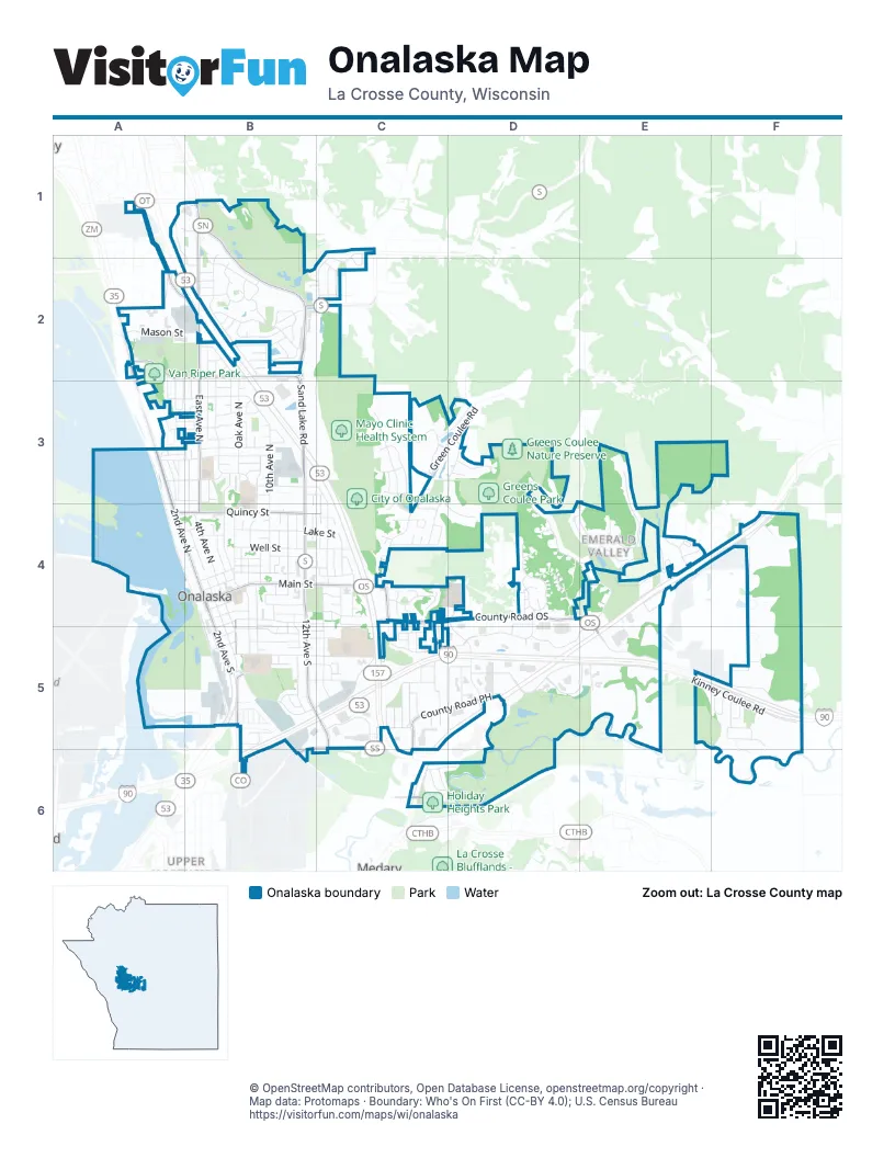
Street index of Onalaska
Each street on the sheet and the grid squares it crosses.
- 2nd Avenue NorthA3, A4, B4
- Main StreetB4, C4
- 2nd Avenue SouthB4, B5
- State Highway 35A2, A3
- East Main StreetC4
- Sand Lake RoadB1, B2, B3, B4
- County Road OSC4, D4, E4, E5
- East Avenue NorthB1, B2, B3, B4
- 12th Avenue SouthB4, B5, C5, C6
- Riders Club RoadA2, B2
- Quincy StreetA4, B4, C4
- Abbey RoadA1, A2, B2
- County Road PHC5, D5
- Oak Avenue SouthB4, B5
- County Highway SSC5, B6, C6
- County Highway SB2
- Enterprise AvenueB6
- South Kinney Coulee RoadD5, E5, F5
- Oak Forest DriveC4, B5, C5
- North Kinney Coulee RoadE5, F5
- 10th Avenue NorthB3, B4
- Green Coulee RoadC3, D3, C4
- 6th Avenue NorthB3, B4
- 4th Avenue NorthA2, A3, B3, B4
- Oak Avenue NorthB2, B3, B4
- Country Club LaneD3, D4, E4
- Franklin StreetB1, B2
- Wilson StreetB5, C5
- Marcou RoadE3, E4
- Emerald Valley DriveE3, E4
- Hickory StreetB4, C4
- Midwest DriveD4, D5
- 8th Avenue NorthB3, B4
- 13th Avenue SouthC4, C5
- Well StreetB4, C4
- Stonebridge AvenueC3, D3, C4
- Aspen Valley DriveC3, C4
- Troy StreetA3, B3
- Green StreetB4, C4, B5
- Lake StreetB4, C4
- 11th Avenue SouthB4, B5
- Rolling Oaks DriveB2
- Johnson StreetB2, B3
- Theater RoadD4, D5
- 14th Avenue NorthC3, C4
- Cedar Creek LaneB1, B2
- Krause RoadC1, C2
- East Larkspur LaneD4
- 3rd Avenue NorthA2, A3, B4
- Cliffview Avenue NorthB2, B3
- Redwood StreetB3, C3
- Monroe StreetB4, C4
- La Crosse StreetB5, C5
- Market PlaceE4, D5, E5
- Gundersen DriveD5, E5
- Court RoadC5
- Grove StreetA3, B3
- Green Bay StreetB5, C5
- 3rd Avenue SouthB4, B5
- Mason StreetA2, B2
- Lauderdale NorthA5, B5
- Fair Meadow WayC3, D3
- Crossing Meadows DriveC5
- Evenson DriveC4
- Hilltopper Park DriveB5
- Oak Timber DriveB2
- 11th Avenue NorthB4
- 9th Avenue SouthB4, B5
- Vilas StreetB3
- 2nd Avenue SouthwestB5
- Pierce StreetB4
- 8th Avenue SouthB4, B5
- Braund StreetD5
- French RoadE3, E4
- Grandview BoulevardC4
- Pine StreetB2, B3
- Pralle Center DriveD5
- Pine Ridge DriveB2
- Juline WayB2
- Spruce StreetA3, B3
- Streblow StreetB2
- Tahoe DriveC3
- Lauderdale PlaceA5, B5
- Windhill StreetB2
- Pralle RoadC4, C5, F5, F6
- Beverly DriveF5
- Summers Day LaneC3
- Windsong LaneF5
- Medary LaneC6
- Pinecrest LaneB5, C5
- Red Cedar CourtA2, A3
- 5th Avenue NorthB4
- Madison StreetB4, C4
- Wild Rose LaneD4
- Gilster StreetC5
- Emerald Drive EastE4
- Winter StreetC5
- Westwood DriveB3
- Pierce RoadF4
- 16th Avenue NorthC4
- Esther DriveC4, C5
- Sandalwood DriveC5
- Springhill WayD3
- West AvenueA3
- 1st Avenue SouthB4, B5
- 4th Avenue SouthB4, B5
- Thomas CourtA1, B1, B2
- Park AvenueA3
- West Larkspur LaneD4
- Schnick RoadA3, B3
- Fairway Creek DriveD4, E4
- Hazelwood LaneB5
- Schafer DriveB4
- Augusta LaneE4
- Lester AvenueD5
- Rosewood TrailB5, C5
- Golfview LaneC2
- Locust StreetB4
- Maplewood DriveC4
- Irvin StreetB4
- Quarry LaneC3, D4
- Commercial CourtB3
- Craig Lane EastB2
- Terrace DriveB3
- 9th Avenue NorthB4
- 12th Avenue NorthB4
- Turnberry LaneB1
- Rylla StreetC2
- East Young DriveC6
- 17th Avenue NorthC4
- Craig Lane WestB2
- King StreetB4
- Kristy LaneA3
- Mary DriveF5
- Park Ridge DriveB3
- Mayfair PlaceC5
- L Hauser RoadB3
- Westview Circle DriveB4
- Walnut PlaceC3
- West Young DriveC6
- 17th Avenue SouthC4
- 16th Avenue SouthC4
- Valley Vue DriveF5
- Hoffman PlaceC6, D6
- National DriveD4, D5
- Charles AvenueB2
- Court Street SouthB4, B5
- Fraser WayB2
- Greenview LaneC2
- Hanson CourtC3, C4
- Birch StreetB2
- Keller CourtC4
- Royal StreetA3, B3
- Landfill RoadE4, F5
- Carol LaneA3, B3
- Carter PlaceA3, B3
- 20th Avenue SouthC5
- East 16 Frontage RoadE4
- 13th Avenue NorthB4
- 15th Avenue NorthC4
- 10th Avenue SouthB4
- First AvenueB4
- Sandside CourtC1, C2
- Critter CourtE5
- Kyle LaneB2
- Nathan Hill RoadF4
- Gordon LaneA3, B3
- Second AvenueC4
- 7th Avenue NorthB4
- Pineview StreetF5
- Bear Paw PlaceC3
- County Road PH WestC5
- Alpine PlaceC3
- Sycamore StreetC5
- Elm StreetB5
- Clearwater DriveC4
- Heritage LaneC4, C5
- Walnut DriveE4
- Crestwood LaneE4
- Fern StreetB5
- Hope CourtB3
- Domke StreetB5
- Pearl StreetB4
- Horman BoulevardB4
- Saint Paul StreetB5
- Shelly LaneB3
- Maple LaneF4
- Canary LaneB5
- Rudy StreetD5
- William DriveC2
- Olympic DriveC3
- Ridgeway AvenueB2, B3
- Oriole LaneB5
- Green CourtC5
- Whispering Winds PlaceB3
- Custer CourtC5
- Larch Avenue NorthB4
- Harter DriveE4
- Birka LaneB2
- 21st Avenue SouthC5
- Commerce RoadA1
- Herman CourtC4
- Barson CourtC5
- Fairfield StreetB5
- Kingswood LaneC4
- Eagle Bluff CourtD4
- Poplar StreetA4, B4
- Century PlaceA1, B1
- Crestwood PlaceE4
- Pine Valley CourtE4
- Meadow LaneB3, C3
- Coronado CircleE4
- 10th Place NorthB4
- Lincoln StreetB5
- Oak DriveE4
- Snowflake PlaceC3
- Elizabeth LaneB3
- 13th PlaceC4
- Lawrence PlaceB3
- Spruce Street EastB3
- Park Avenue WestA3
- Maplewood PlaceC4
- 13th CourtC4
- Afton PlaceC5
- Greenridge DriveB3
- Rayburn PlaceB4
- 5th Avenue SouthB4
- Coachlite Court SouthC4
- Dutton StreetC5
- Edwards LaneA3
- Flint StreetB2
- Oak Park DriveB2
- Willow StreetB2
- Rambler CourtB2
- Ridgeview DriveB3
- Victoria LaneB2
- East Plaza ParkF4
- Cloverdale RoadA1
- Chestnut DriveB2
- Cheyenne DriveB1
- Wood Run PlaceC3, C4
- Garden PlaceB2
- Gertie LaneB5
- Saint Andrews CourtB1
- Fairway CourtC4
- R Stephan PlaceB3
- Stuhr CourtA3
- The OaksB1
- Larkspur LaneD4
- Woodmans DriveE4
- Harmony Point PlaceD3
- Bluebird CourtB4
- Krueger CourtC5
- Springhill LaneC3
- Corinthian AvenueB4, C4
- Hickory LaneE4
- Rachel PlaceB4
- Robert PlaceB3
- Timbercrest Drive EastE4
- Calla CourtD4
- Coachlite Court NorthC4
- Venture PlaceB3
- Valley CourtB5
- Bethanne PlaceB2
- Prairie Clover PlaceD4
- Green Coulee LaneD3
- Schroeder RoadC5
- Ironwood PlaceC4
- Kevin CourtC4
- Meier LaneB2
- Placid CourtB4, B5
- Gail AvenueB3
- 10th CourtB4
- Oakhill CourtE4
- Pleasant CourtB3, B4
- Sunrise CourtB3
- Keith PlaceB4
- Elm DriveE4
- Darwin CourtB3
- Eagle CourtC4
- Frances CourtB3
- Heather CourtD4
- Melcher PlaceB5
- Cedar PlaceC4
- Bentgrass CourtB2, C2
- Bergamot PlaceD4
- Kramer RoadA3
- Putter CourtC4
- Barson PlaceC5
- Monica LaneB3
- Guenther CourtB4
- Johnson DriveB5
- Tillman DriveB5
- Birdie CourtC4
- John StreetB4
- Wilson PlaceB5
- Turnberry CourtB1
- Northern Sands PlaceB3
- Tahoe PlaceC3
- George StreetB5
Places on the map
- 2Brothers Powersports
- Advance Auto Parts
- ALDI
- Altra Federal Credit Union Onalaska Branch
- America's Mattress
- Angelini's
- Applebee's
- Arby's
- Armed Forces Career Center
- Associated Bank
- Audi
- Clearwater Farms
- Community Park
- Crossroads Center
- Dahl Ford
- Eagle Bluff Elementary School
- Festival Foods Support Office
- Glenn Fox Park
- Greens Coulee Nature Preserve
- Greens Coulee Park
- Gundersen Lutheran Onalaska Clinic
- Holiday Heights Park
- Luther High School
- Mayo Clinic Health System
- Meier Farm Park
- Menards
- Onalaska Cemetary
- Onalaska City Hall
- Onalaska High School
- Onalaska Middle School
- Robinson Park
- Rowe Park
- Sam's Club
- Sandalwood Park
- Stoney Creek Inn
- The Golf Club at Cedar Creek
- Van Riper Park
- Walmart Supercenter
- Wisconsin Kenworth - La Crosse
- Woodman's Markets
Next to Onalaska
- Medary
- Upper Northside
© OpenStreetMap contributors, Open Database License, openstreetmap.org/copyright · Map data: Protomaps · Boundary: Who's On First (CC-BY 4.0); U.S. Census Bureau















