

Wisconsin map
La Crosse County map
About 121,060 people live here (Census Bureau, 2024 estimate). The sheet's index lists 300 streets; County Highway M, State Highway 162 and County Highway T cross the most grid squares. Things to do inside the boundary: La Crosse Queen Cruises.
Open the map (PDF, US Letter)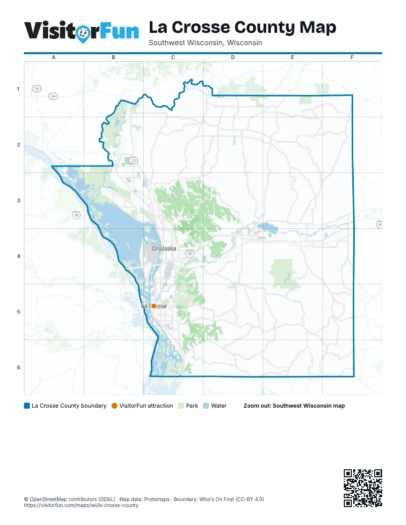
Maps inside La Crosse County
3 maps inside, from the street map of La Crosse County down.
Town
Street index of La Crosse County
Each street on the sheet and the grid squares it crosses.
- American Veterans Memorial Highway/State Trooper Theodore Foss Memorial HighwayB4
- State Highway 33C5, D5, E5, F5
- State Highway 108E1, E2, D3, E3
- State Highway 35B2, C3, C4
- Holmen DriveB2, C3
- Rose StreetC4, C5
- South AvenueC5
- State Road 16D3, E3
- Main StreetB2, C4, F4, C5
- Mormon Coulee RoadC5, C6
- Cass StreetC3, C5
- Losey Boulevard SouthC5
- George StreetC4, C5
- West Avenue SouthC5
- Great River RoadC6
- Jackson StreetC5
- Gillette StreetC4
- La Crosse StreetC4, C5
- Copeland AvenueC4, C5
- 2nd Avenue NorthC4
- State Highway 16E3
- Cameron AvenueC5
- Lang DriveC5
- 4th Street SouthC5
- East Main StreetC4, F4
- 3rd Street SouthC5
- 2nd Avenue SouthC4
- Losey Boulevard NorthC5
- West Avenue NorthC5
- 3rd Street NorthC5
- 4th Street NorthC5
- West George StreetC4
- US 53B1
- Historic Bluff Country Scenic BywayB5
- County Highway MD1, D2, C3, D3, D4, D5, E5, D6, E6
- State Highway 162F1, F2, E3, F3, E4, F4, E5, F5, E6
- County Highway CD2, D3
- County Road YYD5, D6
- Sand Lake RoadC3, C4
- County Highway BC4, D4
- County Road XXB2, B3, C3
- County Road MHB3
- County Road OSC4
- County Highway OTC3
- Ward AvenueC5
- Commercial StreetE4
- South Main StreetC3
- County Road OTC3
- 7th Street NorthC5
- North Main StreetC3
- McHugh RoadB3, C3
- West Gaarder RoadC3
- 17th Avenue NorthC4, E4
- East Gaarder RoadC3
- County Highway DHC3
- County Highway TB1, C1, C2, D2, E2, F2
- County Road DED2, E2, E3
- County Highway DC2, D2, C3
- County Highway VD1, C2, D2, C3
- County Highway AE1, F1
- County Road BD4, E4, F4
- County Highway EE2, E3
- County Highway WC2, D2, C3
- County Highway SC3, D3
- County Highway HE5, E6, F6
- County Road IE5
- County Highway QD1, E1
- County Road MMC6, D6
- County Road EEE2, E3
- County Road ZB3
- County Highway IIE4, E5
- County Road JF4, F5
- County Road CD1, E1, D2
- County Road GF5, F6
- Lakeshore DriveB4, C4
- County Highway JF3, F4
- County Highway OAD4, D5
- County Highway PIE6
- County Highway FC5, D5
- County Highway UE4, F4
- County Highway VVD1, D2
- County Road NND6, E6
- County Highway JBF5
- County Road ND6, E6
- East Avenue NorthC3, C4, C5
- Buol RoadD4, E4
- County Highway TAE1, E2
- Bainbridge StreetC4, C5
- Oak StreetB2, B3, C4, E4, C5
- County Highway GE6, F6
- Airport RoadB4, C4
- County Road ZNB3, C3
- Green Bay StreetC4, C5
- Northshore DriveB3
- County Highway OD4, D5
- 33rd Street SouthC5, C6
- County Highway PF6
- County Highway JJF5
- Old CTH NAB2
- County Highway FOD5
- 16th Street SouthC5
- County Road GIC6
- County Highway TTC1, C2
- 12th Avenue SouthC4
- County Highway YF4
- County Road XF6
- County Road FAC5
- Bliss RoadC5
- County Road ZBB3
- Fanta Reed RoadB4, C4
- County Highway ZB3, C3
- County Highway AEE1, E2
- Dawson AvenueC4
- Riders Club RoadC4
- Clinton StreetC4
- Weston StreetC5
- County Highway DDC2
- Quincy StreetC4
- Abbey RoadC3
- Neshonoc RoadE3, D4
- County Road PHC4
- Sunset DriveC3, C5
- West Elm StreetD4
- East Garland StreetD4, E4
- County Highway SSC4
- North West AvenueD3, D4
- County Road KC6
- County Highway ZZB3
- Leonard StreetD4, C5
- Oak Avenue SouthC4
- North Leonard StreetD4
- 32nd Street SouthC5
- Enterprise AvenueC4
- County Road PF6
- West Garland StreetD4
- 10th Avenue SouthC4, E4
- County Road MD6, E6
- County Highway ZMC3
- East Jefferson StreetD4
- South Oak StreetD4, F4
- Ranger DriveC4
- Long Coulee RoadC3
- County Road OAD5
- North Commercial StreetF4
- Commerce RoadC3
- County Road WC3
- West Jefferson StreetD4
- South Leonard StreetD4
- Goddard StreetC4
- City LoopD4
- Antony RoadE4, E5, F5
- Gills Coulee RoadD3
- Johnson Coulee RoadE2, F2, C3
- Pleasant Valley RoadD4, E4
- Garves Coulee RoadF2, F3
- Jewett RoadE3, F3
- Russlan Coulee RoadD4, E4, D5
- Baker RoadC1, D1, C2, C5
- Casberg Coulee RoadC2
- Herman Coulee RoadE2
- McKinley Valley RoadE3
- East Avenue SouthC5, C6
- North Kinney Coulee RoadC4, D4
- Culpitt RoadF3
- Amsterdam Prairie RoadB2
- Smith Valley RoadC4, C5, D5
- Wanlass RoadE2
- Wildwood Valley RoadC3
- Bina RoadE5
- Johnson StreetC3, C4, C5
- Wuensch RoadD5, E5, D6
- 7th Street SouthC5
- South Kinney Coulee RoadC4, D4
- Davis Creek RoadE1
- King StreetC4, C5
- German Coulee RoadF6
- Evans Dwyer RoadE6
- Niedfeldt RoadF3
- 28th Street SouthC5, C6
- Moos RoadC3, D3, D4
- Farnam StreetC5
- Fishermans RoadC4
- State StreetC5
- Sommers RoadF1
- Swamp RoadD4
- Schaller BoulevardB2
- Briggs RoadB2, B3
- Kammel RoadC6, E6
- Oak Forest DriveC4
- Korn Coulee RoadF5, F6
- Prairie RoadE4, F4
- Eggens Coulee RoadD3
- Welsh Coulee RoadD4, D5
- Bloomer Mill RoadD6
- Breidel Coulee RoadD5, D6
- Market StreetC5
- Big Creek RoadF3
- North Chipmunk RoadC6, D6
- Liberty StreetC4, C5
- Commerce StreetB3, C3, C4, D4
- Krause RoadE1, C3, E4
- Avon StreetC4, C5
- Rotterdam AvenueB2
- 22nd Street SouthC5
- 29th Street SouthC5
- Green Coulee RoadC4
- Bahr RoadD3, D4, D5
- Pierce RoadE3, D4, F4
- 14th Street SouthC5
- Ober RoadD6
- Council Bay RoadB1
- 15th Street SouthC5
- Pinewood DriveC3
- Drectrah RoadD5
- Wolf RoadE4
- Adams StreetC5
- Sweden Coulee RoadD2, D3
- Flaten RoadC2
- Kane StreetC4, C5
- Wolter RoadE2, F2, D4
- Manke Hesselberg RoadE4, F4
- Bergum Coulee RoadD3
- Fennigkoh RoadD4
- Kreibich RoadE6
- Davis RoadF3, E4
- Pine StreetC4, F4, C5
- Skemp RoadE5, D6
- Denton StreetC5
- Skyline DriveC6, D6
- 19th Street SouthC5
- Park AvenueB3, C4, C5
- Charles StreetC4, C5
- 13th Street SouthC5
- Vine StreetC5
- Innsbruck RoadC3, C4, D4
- Easter RoadC5
- Park DriveC3, E4, C5, D6
- Riverview DriveC3, C5, C6
- 21st Street SouthC5
- Ferry StreetC5
- Darling RoadC4, E4, E5
- Mississippi StreetC5
- Birch StreetB2, B3, C3, E4, F4, C5
- Kirschner RoadE5
- 23rd Street SouthC5
- Aspeslet RoadB1, B2
- 20th Street SouthC5
- Asmus RoadD3
- 26th Street SouthC5
- Pettinger Hill RoadF2
- Keil Coulee RoadC4, D4
- Muenzenberger RoadF6
- Roberts RoadD1, D2, C3, F4
- Knobloch RoadD5
- Wood StreetC4, C5
- Larson RoadD2, E5
- Old Co Rd MD4
- Caledonia StreetC4, C5
- River Valley DriveC4, C5
- Sylvester RoadB2, C2
- Radcliffe RoadD1
- Madison StreetC4, C5
- 10th Avenue NorthC4
- Winnebago StreetC5
- Kreibich Coulee RoadE6
- Prospect StreetC4, C5
- Berlin DriveC4, D4
- Loomis StreetC4, C5
- 31st Street SouthC5
- Redfield StreetC5
- Cliffside DriveC5, C6
- Kammel Coulee RoadE6
- Olson RoadC3
- Bunker Hill RoadF5
- 27th Street SouthC5
- Grove StreetC4, E4, C5
- West Franklin StreetD4
- J Jones RoadE3
- Horton StreetB2, C5
- Berg RoadD3, F6
- Bluffview CourtB2
- 10th Street SouthC5
- 6th Avenue NorthC4
- Hagen RoadC5
- Elm StreetB3, C4, D4, E4
- Caroline StreetC4
- 17th Street SouthC5
- Viking AvenueC3
- Three Town RoadD5
- Landfill RoadD4
- Heram RoadB1, C1
- Hanson RoadC2, C3, B4
- Onalaska AvenueC4
- Jordson Coulee RoadD3
- 4th Avenue NorthC4
- Oak Avenue NorthC4
- Country AvenueB2, B3
- La Crescent StreetC4, C5
- Brye RoadE6
- Hartman RoadE2
Things to do on the La Crosse County map
Places on the map
- 7th Street Waterfront
- Bangor
- Bluffside
- Bluffview Park
- Brice Prairie
- Camp Decorah
- Camp Ehawee
- Cass & King Historic District
- Central Northside
- Coulee Experimental Forest
- Coulee Region Riders Club
- Downtown
- Drugan's Castle Mound
- Forest Hills Golf Course
- Fox Hollow Golf Course
- French Island
- French Lake
- Goose Island County Park
- Goosetown
- Grandview-Emerson
- Greens Coulee Nature Preserve
- Greens Coulee Park
- Hintgen
- Hixon Forest
- Hoeth Forest
- Holmen
- Holy Trinity-Longfellow
- Juniper Estates/Mill
- King's Bluff Quarry
- La Crosse
- La Crosse Country Club
- La Crosse County Landfill
- La Crosse Fairgrounds
- La Crosse Marsh
- La Crosse River Conservancy
- Lake Neshonoc
- Lake Onalaska
- Logan Northside
- Lower Northside & Depot
- Van Loon Wildlife Area
Next to La Crosse County
- La Crescent
© OpenStreetMap contributors, Open Database License, openstreetmap.org/copyright · Map data: Protomaps · Boundary: Who's On First (CC-BY 4.0); Quattroshapes (CC BY 2.0)















