

Wisconsin map
Ozaukee County map
About 93,956 people live here (Census Bureau, 2024 estimate). The sheet's index lists 300 streets; Highland Drive, Lilac Lane and Washington Avenue cross the most grid squares. Things to do inside the boundary: Virmond Park and Wisconsin Museum of Quilts & Fiber Arts.
Open the map (PDF, US Letter)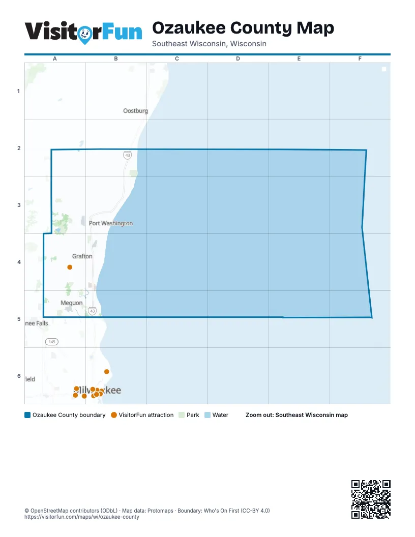
Street index of Ozaukee County
Each street on the sheet and the grid squares it crosses.
- State Highway 57C1, C2, C3
- West Mequon RoadB6, C6, D6
- Wauwatosa RoadC4, C5, C6
- Washington AvenueC2, B4, C4, C5
- South Spring StreetD3, D4
- State Highway 33B3, C3, D3
- Cedarburg RoadC5, C6
- Hillcrest RoadC3, D3, C5
- North Green Bay RoadC3, C4, C6
- Washington StreetC4, D4
- West Grand AvenueD3
- East Green Bay AvenueC3, D3
- West Washington StreetD3, C4
- North Wisconsin StreetD3
- West Dekora StreetC3
- North Franklin StreetD3
- State Highway 60B4
- East Grand AvenueD3
- North Port Washington RoadC4, D4, D5, D6
- County Highway IC1, C2, C3, C4
- County Highway LLD2, D3
- County Highway AB2, C2, D2
- Highland RoadB5, C5, D5
- County Highway WestC3, D3, C4, D4
- County Road HC2, D2, D3
- County Highway DC1, D1
- Sheboygan RoadC4
- West Highland RoadC5
- Fredonia AvenueC2
- Main StreetD1
- South Main StreetC3, C6
- North Main StreetC5, C6
- North Riverside DriveC3
- North Port Washington LaneD6
- County Road A/HC2
- Seven Hills RoadD3
- South Riverside DriveC3
- County Road A/H/IC2
- West Winesap CourtD6
- North Granville RoadB4, B5, B6
- County Highway BD1, D2, D3
- Pioneer RoadB5, C5, D5
- Green Bay RoadD3, C4, C5, C6
- Hawthorne DriveB2, C2, D2, B3
- West Bonniwell RoadB5, C5, D5
- West County Line RoadB6, C6, D6
- Lake Shore RoadD3, D4, D5
- East Sauk RoadC3, D3, B4
- County Road KWD1, D2, D3
- County Highway KKD2, D3
- Pleasant Valley RoadB4, C4
- Cedar Creek RoadB4, C4
- West Freistadt RoadB5, C5
- West Donges Bay RoadB6, C6
- Wasaukee RoadB5, B6
- County Highway KC1, D1, E1
- County Road CD4, D5
- Sauk Trail RoadE1, E2
- Belgium-Kohler RoadC1, C2
- North River RoadC5, C6
- County Highway HB2, C2
- Western RoadB5, C5
- North Lake Shore DriveD5, D6
- County Highway OC2, C3
- Cedar Valley RoadC1, C2
- Lakefield RoadC5, D5
- Hickory RoadB2, B3, B4
- Falls RoadC4, D4
- County Road EC1, C2
- 1st AvenueC4
- Donges Bay RoadB6, C6, D6
- North Royal AvenueD1, E1
- North Middle RoadD1
- County Highway YC2
- Oriole LaneC1, C4, C5, C6
- North Swan RoadC6
- Wisconsin AvenueC4
- River Park RoadB2, C2
- Cheyenne AvenueC4, C5
- North Range Line RoadC6
- Maple RoadC3, C4
- Ulao ParkwayD4
- Lake Shore DriveD5
- Fredonia Kohler RoadC2
- Ulao RoadD4
- North Baehr RoadC6
- West Zedler LaneC6, D6
- County Highway PD2, E2
- Columbia RoadC4, C5
- East Freistadt RoadC5
- North Buntrock AvenueC6
- Beech StreetC1, D1, C4
- Hamilton RoadC5
- North Mill StreetC3
- South Wisconsin StreetD3
- Evergreen RoadC1
- Portland RoadC5
- 12th AvenueC4
- North Fieldwood RoadC5
- W Sunset RdD3
- North Lake DriveD6
- West Chestnut StreetD3
- County Highway ZC2
- North Industrial DriveC6
- South Division StreetD3
- North Moore RoadD3
- Moore RoadD3
- Weston DriveC6
- East Main StreetB3, D3
- North Katharine DriveD6
- Buntrock AvenueC6
- Middle RoadD1, D2
- County Highway CD3
- De la Warr CircleD6
- East Donges Bay RoadD6
- East Mequon RoadD6
- Freistadt RoadB5
- South Royal AvenueD1, D2
- County Line RoadB6
- East Zedler LaneD6
- County Highway CCD3
- North 124th StreetB6
- County Road LLE1
- North 107th StreetB6
- South Mill StreetC3
- West De La Warr CircleD6
- County Highway TC5
- North Pheasant LaneD6
- Jay RoadB1, C1, D1, E1
- Six Mile RoadD1, D2
- Horns Corners RoadC3, C4, C5
- Kay-K RoadD1, D2
- Highland DriveD1, C2, D2, D3, C4, C5
- Bridge RoadB5, C5
- Pioneer DriveB1, C1, C2
- Silver Beach RoadD1, E1
- Lake Church RoadE1, E2
- Evergreen BoulevardC4, C5
- Mink Ranch RoadC3, D3
- Blue Goose RoadC3
- Cedar Beach RoadD2, E2
- Covered Bridge RoadC3, C4
- River RoadB2, C2
- Willow RoadC3, D3
- Willow Valley RoadC2, D2
- Hickory Grove RoadC1, D1
- Sherman RoadB4, C4
- Dixie RoadD2
- East River RoadC3, C4
- Northwoods RoadD3
- Lake DriveE1, D2, E2
- Lincoln BoulevardC5
- West Center RoadC3
- Shady Lane RoadC3, C4
- Birchwood RoadC3
- Meadowlark RoadC2, D2
- North Farmdale RoadB5, B6
- Hawthorne RoadB5, C5
- Fairway DriveC1, C2, C3
- Camp Awana RoadB1, B2
- Sandy Beach RoadD2, E2
- Cold Spring RoadC3
- Saint Finbars RoadC2, C3
- Keup RoadC4
- Riverland RoadC5, C6
- Spring StreetD2, C4, C5, C6
- Lakeland RoadC3, D4
- Dekora Woods BoulevardC3
- Shuttle RouteE2
- Knollwood RoadB3, C3
- Riverside RoadB2
- Blueberry RoadC2, C3
- Cedar Sauk RoadC3, B4
- 17th AvenueC4
- Sunset RoadD3, C5
- 5th AvenueC4
- Riverview DriveC5, C6
- 9th AvenueC4
- Elm DriveB4
- Martin DriveC2, D3, C5
- Ulao Parkway SouthD4
- Lovers Lane RoadD2
- North Holden StreetD3
- Beechwood DriveC5, D6
- Madison AvenueC4, C5
- 11th AvenueC4
- Bobolink AvenueC4
- North Milwaukee StreetC2, D3
- Woodland RoadD2, C4
- South Park StreetC3, D3
- Vega AvenueC5, C6
- East Norport DriveD3
- Parkview DriveC6
- Hickory StreetD2, C4
- Park StreetD1, C3
- River Bend RoadC4, D4
- Market StreetD3
- Pheasant LaneC2, B4, C5
- Crestview DriveC2, D3, C4, B5
- Ridgewood RoadD3, D4
- Grand AvenueC5
- 7th AvenueC4
- North Oriole LaneC6
- Charter MallC6
- West Glen Oaks LaneC5, D5
- Heidel RoadC5
- Maritime DriveD3
- South Milwaukee StreetC2, D3
- Highlander DriveC6
- West Ranch RoadC6
- Trillium RoadD4, D6
- North StreetD1, C4
- Pine StreetC2, C4
- Mee-Kwon Park RoadC5
- Random Lake RoadC1
- Stonegate RoadB5, C5
- Pine BluffC5
- Colonial ParkwayC3
- North Dries StreetC3
- Hilltop RoadB1, C1
- Pebble Beach RoadE1
- Lone Elm RoadD1
- North Progress DriveC3
- Solar AvenueC5, C6
- Alder RoadD1
- Farm RoadD2
- Country LaneB2
- Clay Ridge RoadE1
- 6th AvenueC4
- Sunnyridge RoadE2
- Greystone DriveD3, C5
- Arrowhead RoadC4, D4
- Edgewater RoadC4
- Harrison AvenueC4, C5
- High Point Beach LaneD2, E2, E3
- Saddlebrook LaneC5
- Hanover AvenueC5
- North Davis RoadC5
- Brandt DriveB4
- Lilac LaneD1, D2, E2, C4, C5
- Hidden Valley RoadB4
- River Forest DriveC5, D5
- Saint Augustine RoadB3, C3
- Lakeview Ridge RoadE2
- North Haddonstone PlaceD6
- Highview RoadB2, C2
- Woodside LaneC5, C6
- West Marseilles DriveC5
- Clover Valley RoadC1
- Misty Ridge LaneD3, D4
- North Spring StreetD3
- Pierron LaneD3
- Tallgrass DriveD4
- Willow LaneD3, C4
- McKinley BoulevardC5
- 2nd AvenueD3, C4
- West Chestnut RoadC6
- West Sunnyvale RoadC6
- 16th AvenueC4
- 13th AvenueC4
- Lower Forest Beach RoadE2
- Cedar Creek ParkwayC4
- Redding CircleD1
- Linden Creek LaneB5
- Concord DriveB6, C6
- Summit DriveC2, D3, B4
- North Portland AvenueD5
- West Executive DriveC6
- West Shoreland DriveC5
- Kohler RoadC2
- North Wyngate TraceD6
- Singing Hills RoadB3
- Shady LaneC2, D5
- North Shorecliff LaneD6
- West Pierre LaneD3
- Susan LaneC4, C5
- North Webster StreetD3
- Topview TrailC4, C5
- West Sunnydale LaneC6
- 8th AvenueC4
- Willow Pond WayD4
- Mondlock DriveE1
- Foster RoadC3, D3
- Woodland DriveC4
- Aster StreetD3
- Cedar Ridge DriveC4, C5
- St James LaneC6
- North Benjamin StreetD3
- Commerce StreetD1, C6
- West Portview DriveD3
- Elm StreetD1, C4, C6
- West Grace AvenueC6
- Deerfield RoadC3
- Skyline DriveC4
- Mequon TrailC6
- West Highland DriveC4
- Devonshire DriveC4
- Cedar StreetC4
- North Bobolink LaneC6
- Cedar Beach SouthE2
Things to do on the Ozaukee County map
Places on the map
- Beechwood Farms
- Belgium
- Cedar Creek
- Cedarburg
- Cedarburg Bog
- Cedarburg Bog State Natural Area
- Fire Ridge Golf Club
- Fredonia
- Gazebo Hills
- Grafton
- Harrington Beach State Park
- Hawthorne Hills County Park
- Hawthorne Hills Golf Course
- Huiras Lake State Natural Area
- Lac Du Cours
- Mee-Kwon Park Golf Course
- Mequon
- Mequon County Estates
- Mequon Nature Preserve
- Milwaukee River
- Mud Lake
- North Shore Country Club
- North Shore Estates
- Ozaukee County Mee-Kwon Park
- Park Place
- Port Washington
- River Club of Mequon
- Riveredge Nature Preserve
- Saukville
- Solar Heights
- Spirit Lake Nature Preserve
- Spring Lake
- Spring Lake Pit
- Tendick Nature Park
- The Bog
- Thiensville
- Town of Belgium
- Town of Cedarburg
- Town of Fredonia
- Town of Grafton
Next to Ozaukee County
- Germantown
- Menomonee Falls
- Richfield
- West Bend
© OpenStreetMap contributors, Open Database License, openstreetmap.org/copyright · Map data: Protomaps · Boundary: Who's On First (CC-BY 4.0); Quattroshapes (CC BY 2.0)