

Wisconsin map
River Falls map
About 12,807 people live here (Census Bureau, 2024 estimate). The sheet's index lists 287 streets; State Highway 65, Paulson Road and Powell Avenue cross the most grid squares. Also on it: River Falls Golf Club, Whitetail Ridge MTB Trail and Glen Park.
Open the map (PDF, US Letter)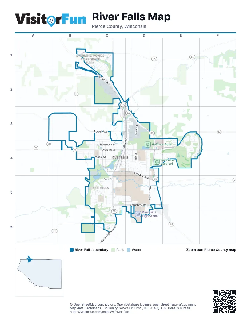
Street index of River Falls
Each street on the sheet and the grid squares it crosses.
- Casey StreetB1, C1
- Chapman DriveB1, C1
- Jersey RoadB1, C2
- Old Chapman DriveB1
- Paulson RoadB1, C1, C2, C3
- Radio RoadB1, B3
- Sage DriveB1
- Sutherland AvenueB1, C1
- Thompson DriveB1
- Balmoral PlaceC1
- Bandle StreetC1
- Brentwood CircleC1
- Cambridge PlaceC1
- County Highway UC1
- Coventry CircleC1, C2
- Derby StreetC1, C2
- Dundee AvenueC1
- Edenburch DriveC1
- Glasgow StreetC1
- Huppert StreetC1, C2
- Kettering RoadC1, C2
- Kingsbarn AvenueC1
- Kingston StreetC1
- Newcastle DriveC1
- Seven Oaks StreetC1
- Sterling Heights DriveC1
- Sussex StreetC1
- Triton AvenueC1
- Antler CourtC2
- Elgin CourtC2
- Highland DriveC2
- Prairie DriveC2
- State Highway 65C2, D2, C3, D3, D5
- Whitetail BoulevardC2
- Park & Ride RoadD2, D3
- Powell AvenueA3, B3, C3, D3
- South Glover RoadB3
- Collins CourtC3
- Commerce CourtC3
- East Woodridge DriveC3
- Howard StreetC3
- Leroy CourtC3
- Leroy LaneC3
- Lucille CourtC3
- North Grove StreetC3, C4
- North Main StreetC3, D3, C4
- North Pearl StreetC3, C4
- North Winter StreetC3, C4
- Oak Ridge DriveC3
- Pine Ridge TerraceC3
- Pomeroy StreetC3, D3
- Riverside DriveC3
- St Croix StreetC3
- Sullivan CourtC3, D3
- Summit RoadC3, D3
- West Pomeroy StreetC3, D3
- West Quarry RoadC3, D3
- West Woodridge DriveC3
- Winter CourtC3
- Benson StreetD3
- East Pomeroy StreetD3
- Mound View RoadD3
- Moundview RoadD3
- North Quarry CourtD3
- North Quarry RoadD3
- Quarry RoadD3
- State Highway 35/65D3, D4, D5
- Troy StreetD3
- County Highway ME3, E4
- Daily PlaceE3
- Dawes PlaceE3, E4
- Fairchild DriveE3, E4
- Glacier AvenueE3
- Hilltop LaneE3
- Liberty RoadE3, F3
- Meadows DriveE3, E4
- Morningside AvenueE3
- Ridgecrest StreetE3, E4
- Rushmore DriveE3, E4
- Tower StreetE3
- Yellowstone DriveE3, E4
- Glenmeadow StreetF3, E4, F4
- Bobwhite StreetB4
- County Road MB4
- Covey DriveB4
- Dry Run RoadB4
- Emily CircleB4, C4
- Field AvenueB4
- Jenna CourtB4
- Kusilek StreetB4, C4
- Mariah CourtB4
- Rolling Hills LaneB4
- Roosevelt StreetB4, C4
- Sunset LaneB4, C4
- Valley Quail DriveB4
- West Division StreetB4, C4
- West Maple StreetB4, C4
- 2nd StreetC4
- Apollo RoadC4
- Clark StreetC4
- East Cascade AvenueC4, D4, D5
- East Cedar StreetC4, D4
- East Division StreetC4, D4, E4
- East Elm StreetC4, D4
- East Locust StreetC4
- East Maple StreetC4, D4
- East Pine StreetC4, D4
- East Walnut StreetC4, D4
- Glen Park RoadC4, C5
- Lawrence StreetC4
- Lewis StreetC4
- Lincoln StreetC4
- Marcella CourtC4
- North 2nd StreetC4, D4
- North 3rd StreetC4, D4
- North Clark StreetC4
- North Dallas StreetC4
- North Falls StreetC4
- North Freemont StreetC4
- North Fremont StreetC4
- North Lewis StreetC4
- North RiverwalkC4
- Roosevelt CourtC4
- South 2nd StreetC4
- South 3rd StreetC4, C5
- South 4th StreetC4, D4
- South Apollo RoadC4
- South Dallas StreetC4
- South Falls StreetC4
- South Freemont StreetC4
- South Grove StreetC4
- South Main StreetC4, C5, C6
- South Pearl StreetC4
- South RiverwalkC4
- South Winter StreetC4
- Spring StreetC4, D4
- Spruce StreetC4, C5
- State StreetC4, C5
- Sylla StreetC4
- Union StreetC4, D4
- Vine StreetC4
- Wesley CourtC4
- West Cascade AvenueC4
- West Cedar StreetC4
- West Elm StreetC4
- West Locust StreetC4
- West Pine StreetC4
- West Roosevelt StreetC4
- West Walnut StreetC4
- Winter StreetC4
- 5th StreetD4
- Birch StreetD4, D5
- Birchcrest DriveD4, D5
- Birchcrest LaneD4, D5
- Crescent StreetD4
- Cudd AvenueD4
- Falcon DriveD4
- Golf View DriveD4, E4
- Greenwood CemeteryD4
- Hanson DriveD4
- Hazel StreetD4
- Hillcrest StreetD4
- Lake StreetD4
- Linden StreetD4
- Morgan RoadD4
- North 4th StreetD4
- North 6th StreetD4
- North 7th StreetD4
- North 8th StreetD4
- North 9th StreetD4
- North Wasson LaneD4
- Oak Knoll AvenueD4
- Parkview LaneD4
- Pierce StreetD4
- South 6th StreetD4, D5
- South 8th StreetD4
- South 9th StreetD4
- South Wasson LaneD4, D5
- Sunwood CourtD4, E4
- Sunwood Valley LaneD4
- Wasson CircleD4
- Wasson CourtD4
- Wild Rose AvenueD4, C5, D5
- Buford CourtE4
- East View CourtE4
- Fisher WayE4
- Meredith CircleE4
- Pika TrailE4
- Range View LaneE4
- Reynolds StreetE4
- Southbend RoadE4
- Sunnyslope CourtE4
- Tremont LaneE4
- Vista CircleE4
- Westgate PlaceE4
- Williams AvenueE4, F4
- 965th StreetC5
- 975th StreetC5
- Bartosh LaneC5
- Bennett StreetC5, C6
- Broadway StreetC5, D5
- Butternut CourtC5
- Cascade CourtC5
- Cemetery RoadC5, D5
- Church StreetC5
- Devin LaneC5
- Douglass CourtC5
- East Charlotte StreetC5
- East Johnson StreetC5, D5
- East Park StreetC5
- Emogene Nelson AvenueC5, D5
- Emory CircleC5
- Emory DriveC5
- Foster CourtC5
- Foster StreetC5
- Greenwood Valley DriveC5, C6
- Griffey StreetC5, D5
- Hamilton CourtC5
- Hamilton DriveC5
- High Ridge RoadC5
- Jefferson CourtC5
- Jefferson StreetC5
- Julie AvenueC5
- Kennedy StreetC5, D5
- Kimberly CircleC5, C6
- Kinni CourtC5
- Lumphrey CourtC5
- Macie StreetC5, C6
- Mary LaneC5
- Meadowbrook LaneC5
- Nicholas PlaceC5
- Nicole LaneC5
- Oak StreetC5
- Old Rail Road Bed PathC5, D5
- Orange StreetC5
- River Hills DriveC5
- River Hills RoadC5
- River Ridge CourtC5
- River Ridge RoadC5
- Rocky Branch CourtC5
- Sorensen StreetC5, C6
- Sycamore StreetC5
- Taylor AvenueC5
- Washington CourtC5
- Washington StreetC5
- West Cemetery RoadC5
- West Charlotte StreetC5
- West Johnson StreetC5
- West Park StreetC5
- Wisconsin StreetC5, C6
- 940th StreetD5
- 945th StreetD5
- 950th StreetD5, D6
- Lilac AvenueD5
- River Falls High SchoolD5, D6
- Rodao DriveD5, D6
- Short StreetD5
- Southfork DriveD5
- Southridge RoadD5, D6
- State Highway 29D5, C6
- State Highway 29/35/65D5
- Valley View DriveD5
- Wildcat CenterD5
- Wildcat CourtD5
- Windflower StreetD5, D6
- 1015th StreetC6
- 770th AvenueC6
- 805th AvenueC6
- Aurora CircleC6
- Beardslee PlaceC6
- Charmin AvenueC6
- County Road FFC6
- Diana PlaceC6
- Eva PlaceC6
- Jessica PlaceC6
- Kamloops PlaceC6
- Kari StreetC6
- Kiana CourtC6
- Kristy StreetC6
- Michael LaneC6
- Raymond AvenueC6
- Shirley AvenueC6
- Smith CircleC6
- Spring Creek DriveC6
- Square Tail StreetC6
- Steelhead DriveC6
- Morning Glory DriveD6
Places on the map
- Ace Hardware
- ALDI
- Bernards
- Boulder Ridge Park
- BP Amoco
- Brickhouse Music
- Campus Lab Garden
- Chalmer Davee Library
- CHILD Center (Day Care)
- City of River Falls Storm Shelter
- Coratel Inn and Suites
- Country Inn River Falls
- Culver's
- Dahlka Garden
- Dick's Fresh Market
- Dick's Hometown Liquor
- Dollar General
- Dunkin'
- Eagle Storage
- Emma's Bar
- Glen Park
- Golf View East Park
- Golf View West Park
- Greenwood Cemetery
- Highview Meadows Park
- Hoffman Park
- Intramural/ Rugby fields
- Lake George
- Lake Louise
- Mound Park
- PAY3
- River Falls Area Hospital
- River Falls City Hall
- River Falls Golf Club
- River Falls High School
- River Falls Post Office
- Rocky Branch Elementary School
- Sterling Ponds Park
- Westside Elementary School
- Whitetail Ridge MTB Trail
© OpenStreetMap contributors, Open Database License, openstreetmap.org/copyright · Map data: Protomaps · Boundary: Who's On First (CC-BY 4.0); U.S. Census Bureau















