

Wisconsin map
Pierce County map
About 43,380 people live here (Census Bureau, 2024 estimate). The sheet's index lists 300 streets; US Highway 10, State Highway 29 and 170th Street cross the most grid squares. Things to do inside the boundary: Crystal Cave and Kinnickinnic State Park.
Open the map (PDF, US Letter)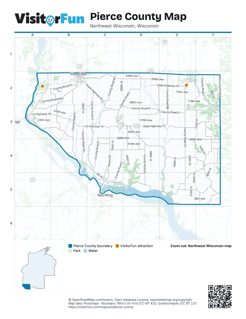
Maps inside Pierce County
2 maps inside, from the street map of Pierce County down.
City
Street index of Pierce County
Each street on the sheet and the grid squares it crosses.
- US Highway 10A3, B3, C3, D3, D4, E4, F4
- State Highway 29B2, C2, D2, E2, F2, A3, B3
- State Highway 35A3, B3, B4, C4, E5
- Great River RoadC3, C5, D5, E5
- State Highway 72D3, E3, F3
- Route 63C3, C4, C5
- State Highway 65B2, C2, C3
- Winter Avenue WestF3
- WI-35C4, C5
- South Main StreetB2, F3
- West Main StreetC3
- US Highway 63D3
- Cemetery RoadB2, D5
- East Cascade AvenueB2
- 5th StreetB2, E2, D5
- Jefferson StreetB2, A3
- North Maple StreetC3
- West Winter AvenueF3
- Main StreetF3, F4, D5
- East Main StreetC3, D3
- State Highway 35/65B2
- Spring StreetB2, E2
- Lake Street NorthA3
- State Highway 29/35/65B2
- East Race AvenueF3
- Broad StreetA3, B4
- West Race AvenueF3
- Omaha AvenueF3
- 10th AvenueD2
- Scott Street NorthF3
- Point Douglas Drive SouthA3
- Vietnam War Veterans Memorial HighwayD3
- County Road CCE2, E3, E4, E5, F5
- County Road ND2, E2, C3, D3, E3
- County Road CD3, C4, D4, C5
- County Road EB2, B3, E5
- County Road AE4, E5
- County Road DD4, D5
- County Road FA2, A3
- County Road TF2, F3
- County Road BE2, F2
- County Road EED4, D5
- County Road VC4, D4
- County Road DDD3, D4
- County Road PF2, F3
- County Road VVC4, C5
- County Road MA2, B2
- West Division StreetB2
- East Division StreetB2
- North Public StreetF2, F3
- North Main StreetB2, F3
- 2nd StreetB2, A3, E5
- North 2nd StreetB2, E2
- South 2nd StreetB2, E2
- State Highway 128F2
- County Highway MB2
- County Highway FA2
- 450th AvenueB3, C3, D3, D4, E4, F4
- County Road SF3, E4, F4, E5
- County Road OC2, C3, C4
- County Road GD3, E3, F3
- 50th StreetF2, F3, F4, F5
- County Road KC3, C4, C5
- 170th StreetD2, E2, F2, F3, E4, F4, F5
- County Road JC2, D2, C3, F5
- County Road BBE2, E3
- County Road QQB2, B3
- County Road UF4, F5
- County Road WC2
- County Road OOB3, B4
- County Road FFA2, B2
- County Road SSF5
- County Road MMA2, B2
- 560th AvenueA3, B3, C3, F3
- County Road PPF3
- County Road YD2
- County Road ZZF4
- County Road KKC4
- County Road UUF5
- South Public StreetF3
- County Road ZF4
- County Road XF4
- County Road HE5
- County Road AAE5
- County Road IE2
- McKay AvenueE2
- County Road HHE4, F4
- Newman AvenueE2
- Pine Avenue EastF4
- Maple Avenue WestF4
- River StreetE2
- North Winter StreetB2
- South Winter StreetB2
- County Highway BBE2
- West Cascade AvenueB2
- Akers StreetE2
- Winter StreetB2
- Mann LaneB2
- County Highway CCF5
- 570th AvenueA3, B3, C3, D3, E3, F3
- 690th AvenueA2, B2, C2, D2, E2, F2
- 770th AvenueA2, B2, C2, D2, E2, F2
- 290th AvenueB4, C4, D4, F4
- 490th StreetD2, D3, D4, D5
- 710th AvenueB2, C2, D2, E2, F2, F3
- 850th AvenueA2, D2, E2, F2
- 410th AvenueB4, C4, D4, E4, F4
- 450th StreetD2, D3, D4, D5, E5
- 610th StreetD2, D3, D4
- 490th AvenueA3, B3, C3, D3, E3, F3
- 370th AvenueB4, C4, D4, E4, F4
- 410th StreetE2, E3, D4, E4
- 650th StreetD2, D3, D4
- 290th StreetE2, E3, E4, E5
- 530th StreetD2, D3, D4, D5
- 610th AvenueC3, D3, E3, F3
- 750th StreetC2, C3, C4
- 110th StreetF2, F3, F4, F5
- 890th AvenueA2, D2, E2, F2
- 170th AvenueC5, D5, E5, F5
- 690th StreetC2, D2, C4, C5
- 210th AvenueD4, E4, C5, D5, E5, F5
- 730th StreetC2, C3, C4, C5
- 330th AvenueC4, D4, E4, F4
- 130th StreetF2, F3, F4, F5
- 330th StreetE2, E3
- 650th AvenueC3, E3
- 620th StreetD2, D4
- 390th AvenueC4, E4
- 230th AvenueC4, D4, E4, F4
- 950th StreetB2, B3
- 350th AvenueF2, C4, D4, E4, F4, E5
- 430th AvenueB4, C4, D4, E4, F4
- 870th AvenueA2, C2, D2, E2, F2
- 270th AvenueC4, D4, E4, F4
- 210th StreetE3, E4, E5
- 190th StreetE2, E3, E4, E5
- 250th AvenueF3, C4, D4, E4
- 730th AvenueC2, D2, E2
- 150th StreetF2, F3, F4, F5
- 620th AvenueA3, B3
- 830th StreetC3, C4, C5
- 640th AvenueA3, B3, C3, E3
- 810th AvenueC2, D2, E2
- 810th StreetC2, C3, C4, C5
- 320th AvenueB4, C4, D4
- 850th StreetC2, C4
- 190th AvenueD5, E5, F5
- 1090th StreetB2, B3
- 385th StreetE4, E5
- 510th StreetD2, D3, D4, D5
- 220th StreetD2, E2, E4
- 150th AvenueC5, D5, E5, F5
- 970th StreetB2, B3, B4
- 480th AvenueB3, C3, D3
- 590th StreetD2, D3, D4, D5
- 760th AvenueC2, D2
- 870th StreetC2, C3, C4
- 670th StreetD3, D4, D5
- 1170th StreetA2, B2, A3, B3
- 130th AvenueC5, D5, E5, F5
- 840th AvenueA2, B2
- 710th StreetC2, C3, C4
- 145th AvenueC5, F5
- 320th StreetF2, E4
- 770th StreetC2, C3, C4, C5
- 790th StreetC2, C3, C4, C5
- 270th StreetE2, E3, E4
- 910th StreetB2, C2, C3
- 530th AvenueB3, C3, E3, F3
- 70th StreetF3, F4, F5
- 70th AvenueE5, F5
- 570th StreetD2, D3, D4, D5
- 160th AvenueC5, E5
- 465th AvenueD3, E3, E4
- 550th StreetD4
- 20th AvenueE5
- 110th AvenueE5, F5
- 350th StreetE3, E4
- 200th AvenueE4, D5, E5
- 452nd StreetD5
- 430th StreetD3, D5
- 825th StreetC3, C5
- 300th StreetE4, E5
- 50th AvenueE5, F5
- 80th StreetF4, F5
- 720th AvenueA2, D2
- 820th AvenueA2, D2, C3, C4
- 1200th StreetA3
- 1250th StreetA2, A3
- 265th AvenueE4, F4
- 1130th StreetB2, B3, B4
- 20th StreetF3, F5
- 840th StreetC3, C4, C5
- 135th AvenueC5, D5
- 340th AvenueC4, D4
- 1050th StreetB3, B4
- 235th AvenueE4
- 1100th StreetB3, B4
- 900th StreetC2
- 780th AvenueC2, D2
- 45th StreetF2, F4
- DNR RoadA2
- 750th AvenueD2, E2
- 510th AvenueC3, F3
- 90th StreetF3, F5
- 500th AvenueB3
- 40th AvenueE5, F5
- 1070th StreetB2, B3
- 860th StreetC3, C5
- 280th StreetE4
- 830th AvenueC2
- 720th StreetC2, C3
- Van Buren RoadE2
- 400th StreetE4
- 1110th StreetB3, B4
- 630th AvenueD3, F3
- 1150th StreetB3
- 250th StreetE2, E5
- 580th AvenueA3, B3, C3, D3
- 1220th StreetA2, A3
- Pierce-Saint Croix RoadE2, F2
- 30th StreetF2, F4
- 740th AvenueB2, C2
- 1005th StreetB4
- 310th AvenueE4, F4
- 820th StreetC2
- 300th AvenueB4, D4
- Harmony RoadD2
- 1000th StreetB3
- 757th StreetA2
- 120th AvenueD5, E5
- 280th AvenueF4
- 566th AvenueB3
- 100th AvenueE5, F5
- Golf View DriveB2, C2
- Monroe StreetA3
- 1160th StreetB2, B3
- 272nd StreetE5
- 740th StreetC3
- 1040th StreetB3
- 197th StreetE5
- 497th AvenueA3, B3
- 285th AvenueC4
- 435th AvenueB4
- 745th StreetC3
- 420th StreetE5
- 244th StreetE5
- 76th StreetF5
- South Wasson LaneB2
- 165th AvenueC5, D5
- Pearl StreetA3
- 1208th StreetA3
- 760th StreetC3, C5
- West Maple StreetB2
- 920th StreetB2, C2
- 945th StreetB2, B4
- 1015th StreetB2
- 754th AvenueB2
- 800th StreetC3, C4
- 521st AvenueB3
- 455th AvenueD3, E3, D4
- 240th StreetE5
- 375th StreetE5
- 1060th StreetB2
- 800th AvenueB2, C2, D2
- 805th StreetC2, C5
- 600th AvenueE3
- Wild Rose AvenueB2
- 380th StreetE5
- South Maple StreetC3
- 140th AvenueC5, E5
- 846th AvenueA2
- South Piety StreetC3
- 545th StreetD5
- 744th AvenueB2
- 790th AvenueD2, E2
- 670th AvenueE3
- Orrin RoadA3
- North Grant StreetC3
- Dexter StreetA3
- 140th StreetF4, F5
- 550th AvenueB3
- 460th AvenueB3, C3
- 1323rd StreetA3
- Saddle Club RoadC2
- Walnut StreetA3
- Old Rail Road Bed PathB2
- Partridge Avenue WestF2, F3
- 385th AvenueC4
- Emogene Nelson AvenueB2
- 1180th StreetA3
- 470th AvenueB3
- 1126th StreetB2
- 1165th StreetB3
- Canton StreetA3
- South StreetA3, C3
- Maple RoadF5
- 370th StreetE3, E4, E5
- 1230th StreetA2, A3
Things to do on the Pierce County map
Places on the map
- Bay City
- Clifton Highlands Golf Club
- Clifton Hollow Golf Club
- Dead Slough Lake
- Diamond Bluff Association
- Ellsworth
- Elmwood
- Gantenbein Lake
- Hager City Plant
- Kinnickinnic State Park
- Maiden Rock
- Manion Wildlife Area
- Mud Lake
- Nugget Lake County Park
- Nugget Lake;Nugget Lake 18
- Pierce County Islands Wildlife Area
- Pine Creek Fishery Area
- Plum City
- Prescott
- Puffball
- River Falls Golf Club
- Spring Valley
- Spring Valley Golf Course
- Town of Clifton
- Town of Diamond Bluff
- Town of El Paso
- Town of Ellsworth
- Town of Gilman
- Town of Hartland
- Town of Isabelle
- Town of Maiden Rock
- Town of Martell
- Town of Oak Grove
- Town of River Falls
- Town of Rock Elm
- Town of Salem
- Town of Spring Lake
- Town of Trenton
- Town of Trimbelle
- Town of Union
Next to Pierce County
- Red Wing
© OpenStreetMap contributors, Open Database License, openstreetmap.org/copyright · Map data: Protomaps · Boundary: Who's On First (CC-BY 4.0); Quattroshapes (CC BY 2.0)















