

Wisconsin map
Sister Bay map
About 1,170 people live here (Census Bureau, 2024 estimate). The sheet's index lists 66 streets; State Highway 42, West Little Sister Road and Country Lane cross the most grid squares. Also on it: Al Johnson’s Swedish Restaurant, Aurora Health Center and Bay Ridge Golf Course.
Open the map (PDF, US Letter)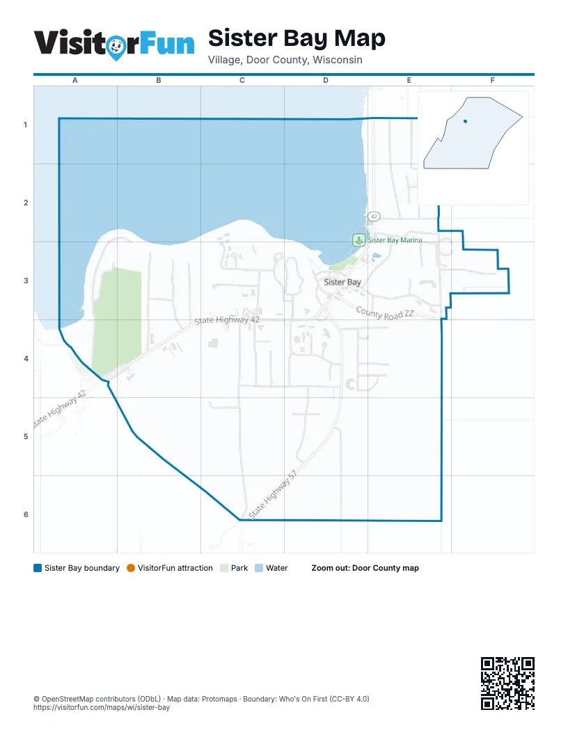
Street index of Sister Bay
Each street on the sheet and the grid squares it crosses.
- Birchwood DriveE1, E2
- Hill RoadE1
- North Spring RoadE1, E2
- State Highway 42E1, E2, D3, E3, A4, B4, C4, D4
- Trillium LaneE1, E2
- West Little Sister RoadA2, B2, A3, B3, A4, B4
- Bluebird LaneE2
- Cardinal CourtE2
- North Crescent RoadE2, F2, F3
- Pheasant CourtE2
- Robin LaneE2
- Scandia RoadE2
- South Spring RoadE2, D3, E3
- Sunset RoadE2
- Woodcrest RoadE2, E3, E4, E5
- Golf RoadA3
- Forest LaneB3, B4
- Meadow LaneB3, B4
- Westwood DriveB3, B4
- Woodland DriveB3
- Jung Wirth CourtC3
- Jungwirth CourtC3
- Mariners Point DriveC3, D3
- North Highland RoadC3, C4
- Sunnyside RoadC3
- Bluffside LaneD3
- County Road ZZD3, E3
- Gateway DriveD3, D4
- Maple DriveD3
- Mill RoadD3, E3
- Parkview DriveD3
- Parkview LaneD3
- Post Office LaneD3
- Regatty WayD3
- Sister Bluff DriveD3, D4
- State Highway 57D3, D4, D5, C6
- Autumn CourtE3, F3
- Claflin LaneE3
- Mill CircleE3
- Mill LaneE3
- Scogland CourtE3
- South Crescent RoadE3, F3
- Woodcrest CourtE3
- Woodcrest LaneE3
- Country LaneA4, B4, B5, B6, C6
- Pebble Beach RoadA4
- Bittersweet LaneC4
- Cherrywood CourtC4
- Cherrywood LaneC4, D4
- Fieldcrest RoadC4, C5, C6
- South Highland RoadC4
- Applewood RoadD4
- Canterbury LaneD4, E4
- Country Walk DriveD4
- Country Walk LaneD4
- Cut Stone CourtD4
- Hidden Maples PlaceD4, E4
- Judith Blazer DriveD4
- Koessl LaneD4
- Meadow Wood DriveD4, E4
- Somerset DriveD4, E4
- Villa DriveD4, E4
- Fieldcrest LaneC5
- Northwoods DriveD5
- Orchard DriveD5, D6
- Flint Ridge RoadC6, D6, E6
Places on the map
- Al Johnson’s Swedish Restaurant
- Aurora Health Center
- Bay Ridge Golf Course
- Cherrywood Court
- Church Hill Inn
- Coachlite Inn
- Cut Stone Court
- Grasse's Grill
- Jerry's Flowers
- Jung Wirth Court
- LURE Restaurant
- Nicolet National Bank
- Open Hearth Lodge
- Peach Barn Farmhouse and Brewery
- Pheasant Park
- Piggly Wiggly
- Pirate's Cove
- Sister Bay
- Sister Bay beach
- Sister Bay Beach
- Sister Bay Bowl
- Sister Bay Library
- Sister Bay Marina
- Sister Bluff Drive
- Sunnyside Road
- Wild Tomato Wood-Fired Pizza and Grille Sister Bay
© OpenStreetMap contributors (ODbL) · Map data: Protomaps · Boundary: Who's On First (CC-BY 4.0)