

Wisconsin map
South Milwaukee map
About 20,233 people live here (Census Bureau, 2024 estimate). The sheet's index lists 129 streets; 15th Avenue, Oak Creek Parkway and 16th Avenue cross the most grid squares. Also on it: Blakewood, Downtown South Milwaukee and Drexel Highlands.
Open the map (PDF, US Letter)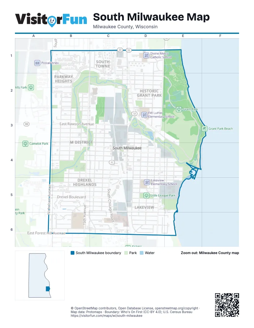
Street index of South Milwaukee
Each street on the sheet and the grid squares it crosses.
- Frontage RoadA1, A2
- Nicholson AvenueA1, B1, A3, A4
- 16th AvenueB1, B2, B3, B4, B5
- Carroll AvenueB1, C1
- Carroll CourtB1
- Cypress CourtB1
- East College AvenueB1, C1, D1
- Hemlock CourtB1
- Hickory StreetB1
- Holly LaneB1
- Laurel LaneB1
- Parkway DriveB1, C1, B2
- Poplar AvenueB1
- South Elaine AvenueB1
- South Illinois AvenueB1
- South Pennsylvania AvenueB1
- South Robert AvenueB1
- Spruce CourtB1, B2
- Tamarack StreetB1
- Willow LaneB1, B2, B3, A6
- 11th AvenueC1, C2, C4, C5
- 14th AvenueC1, C3, C4, C5
- 15th AvenueC1, B2, B3, B4, B5, B6
- Carrington AvenueC1, D1
- Davis AvenueC1, D1
- Edgar AvenueC1, C2
- James CircleC1
- North Chicago AvenueC1, D1, D2, D3
- Park AvenueC1, C2, D2
- South Creekside DriveC1
- Southtowne CourtC1
- Southtowne DriveC1, C2
- Southtowne PlaceC1, C2
- Badger AvenueD1
- Brookdale CourtD1
- Brookdale DriveD1
- Emerson AvenueD1, D2
- Fairview AvenueD1, D2, D3
- Kirkwood AvenueD1, D2
- South Lake DriveD1, E1, D2, D3
- St Sylvester DriveD1
- Oak StreetA2, B2, C2, D2
- 17th AvenueB2, B3, B4, B5, B6
- 18th AvenueB2, B3, B4, B6
- Beech StreetB2
- Cherry StreetB2, D2
- Elm AvenueB2, C2, D2
- Juniper CircleB2
- Linden CircleB2
- Oak Creek ParkwayB2, C2, D2, B3, D3, D4
- Pine StreetB2, C2, D2
- Walnut StreetB2, D2
- Sycamore AvenueC2, D2
- Aspen StreetD2
- Grant Park DriveD2, E2, E3, E4
- Memorial DriveD2, D3
- East Rawson AvenueA3, B3, C3, D3
- Cedar StreetB3, C3
- Chestnut StreetB3, C3
- Manitoba AvenueB3, C3, D3
- Maple StreetB3, C3
- Minnesota AvenueB3, C3, D3
- Missouri AvenueB3, C3
- Monroe AvenueB3, C3, D4
- 12th AvenueC3, C4
- 13th AvenueC3, C4, C5
- 10th AvenueD3, C4, D4
- 7th AvenueD3, D4, D5, D6
- 8th AvenueD3, D4, D5, D6
- 9th AvenueD3, D4, D5, D6
- Hawthorne AvenueD3, E3, E4
- Mill RoadD3, D4
- Rawson CourtD3
- Marshall AvenueA4, B4, C4, D4, E4
- Madison AvenueB4, C4, D4
- Marquette AvenueB4, C4, D4, E4
- Menomonee AvenueB4, C4, D4, E4
- Michigan AvenueB4, C4, D4, E4
- Milwaukee AvenueB4, C4, D4
- Cleveland PlaceC4
- Harrison PlaceC4
- Heritage WayC4, D4, C5, D5
- Marshall CourtC4, D4
- Montana AvenueC4, D4, E4
- South Chicago RoadC4, C5, C6
- 6th AvenueD4, D5, D6
- East Oak Creek ParkwayD4, E4
- South 5th AvenueD4, D5, D6
- 3rd AvenueE4, E5, E6
- 4th AvenueE4, E5, D6
- Lake Shore BoulevardE4
- Drexel BoulevardA5, B5, C5, D5
- Manitowoc AvenueA5, B5, C5, D5
- 17th PlaceB5
- Blake AvenueB5, C5, D5
- Blake CourtB5
- Blakewood AvenueB5, B6
- Blakewood CourtB5
- Columbia AvenueB5, C5, D5
- Harmony LaneB5, B6, C6
- Mackinac AvenueB5, C5, D5
- Manistique AvenueB5, C5, D5
- Marion AvenueB5, C5, D5, E5
- Sanctuary DriveB5
- Sherman AvenueB5, C5, D5
- Sherman CourtB5
- MarionC5
- Russet LaneC5, C6
- Bay Heights DriveD5
- Marina RoadD5, E5
- Tomarza CourtD5
- Kristin LaneA6, B6
- Willow CourtA6
- Clark CourtB6
- East Forest Hill AvenueB6, C6
- Edgewood AvenueB6, C6, D6, E6
- High Ridge CourtB6
- Lakeview AvenueB6, C6, D6
- Noel DriveB6, C6
- South 15th AvenueB6
- South Parkridge DriveB6
- Williams AvenueB6, C6, D6, E6
- Noel CourtC6
- South Newbury DriveC6
- South Yorkshire DriveC6
- Brooklawn CircleD6
- Clark AvenueD6
- Hillcrest AvenueD6
- Lakeview RoadD6, E6
Places on the map
- Advance Auto Parts
- ALDI
- American Legion Post 27 Clubhouse, Bar, & Hall
- Associated Bank
- Blakewood
- Blakewood Elementary School -
- Bucyrus Club
- CHI Franciscan Villa
- Cousins Subs
- Divine Mercy Catholic School
- Downtown South Milwaukee
- Drexel Highlands
- EW Luther Elementary School
- Ferch's Beachside Grille
- First Congregational Church Cemetary
- Franciscan Courts
- Glamour Threading
- Grant Park
- Grant Park Beach
- Grant Park Golf Course
- Grant Park Plaza
- Great Clips
- Grobschmidt Pool
- Historic Grant Park
- Historic Lakeview
- John Galewski Field
- Lakeshore
- Lakeview
- Lakeview Elementary School
- Little League Park
- M District
- McDonald's
- North Chicago Avenue
- Parkway Heights
- Rawson Park
- School District of South Milwaukee
- South Chicago Avenue
- South Milwaukee Lagoon Pond
- South Towne
- Wil-O-Way Grant
© OpenStreetMap contributors, Open Database License, openstreetmap.org/copyright · Map data: Protomaps · Boundary: Who's On First (CC-BY 4.0); U.S. Census Bureau















