

Wisconsin map
Sturgeon Bay map
About 9,940 people live here (Census Bureau, 2024 estimate). The sheet's index lists 237 streets; State Highway 42/57, South Neenah Avenue and North 11th Place cross the most grid squares. Also on it: AmericInn by Wyndham Sturgeon Bay, Amity Field and Apple Valley Lanes.
Open the map (PDF, US Letter)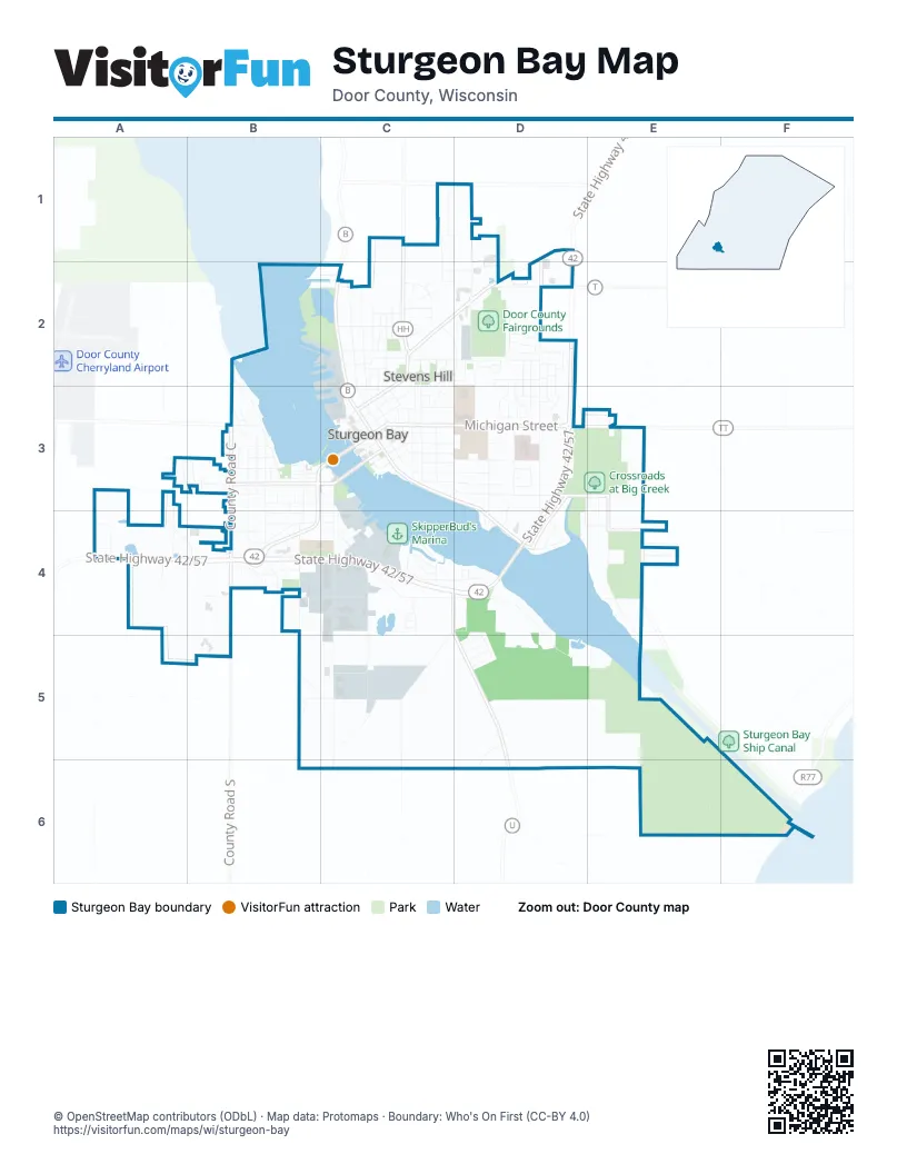
Street index of Sturgeon Bay
Each street on the sheet and the grid squares it crosses.
- Dove StreetC1
- Eagle StreetC1, D1
- North 11th PlaceC1, C2, C3
- North 12th PlaceC1, D1, D2
- North 8th AvenueC1, C2, C3
- Egg Harbor RoadD1, C2, D2
- Gordon RoadD1
- North 18th AvenueD1, D2, D3
- Old Highway RoadD1
- Peterson RoadD1, D2
- State Highway 42/57D1, D2, D3, A4, B4, C4, D4
- Alabama StreetB2, C2, D2
- Bluebird DriveB2, C2
- Florida StreetB2, C2, D2
- North Duluth AvenueB2, B3
- North Duluth PlaceB2, B3
- Sunset DriveB2, C2
- Alabama CourtC2
- Alabama PlaceC2
- Belmar PlaceC2
- Belmar StreetC2
- Bluebird PlaceC2, D2
- Bluebird StreetC2, D2
- Bonnie View DriveC2
- Cherry CourtC2
- Colorado PlaceC2, D2
- County Road BC2, C3, D3
- Delaware StreetC2, D2
- Erie StreetC2, D2
- Georgia StreetC2, D2
- Huron StreetC2, D2
- Jefferson PlaceC2, C3, D3
- Jefferson StreetC2, C3
- North 10th PlaceC2, C3
- North 12th AvenueC2, D2, D3
- North 3rd AvenueC2, C3
- North 4th AvenueC2, C3
- North 5th AvenueC2, C3
- North 5th PlaceC2, C3
- North 6th AvenueC2, C3
- North 6th PlaceC2
- North 7th AvenueC2, C3
- North 7th PlaceC2
- North 8th CourtC2
- North 8th PlaceC2, C3
- North 9th AvenueC2, C3
- North 9th CourtC2
- Delaware DriveD2
- Huron CourtD2
- Iowa StreetD2, C3
- Jaycee CourtD2
- North 14th AvenueD2, D3
- North 14th PlaceD2
- North 15th DriveD2, D3
- North 15th PlaceD2, D3
- North 16th DriveD2, D3
- North 16th PlaceD2, D3
- North 17th DriveD2, D3
- North 18th PlaceD2, D3
- North 19th AvenueD2, D3
- North 19th DriveD2
- Juniper StreetA3, B3
- North Bayfield AvenueA3
- North Columbia AvenueA3
- Sawyer DriveA3
- South Bayfield AvenueA3
- South Columbia AveA3, A4
- West Maple StreetA3, B3
- Baraboo AvenueB3
- Barrick RoadB3
- County Road CB3, B4
- Cumberland AvenueB3
- East Locust CourtB3, C3
- East Maple StreetB3, C3
- East Oak StreetB3, C3
- East Pine StreetB3, C3
- Lawton PlaceB3
- North Ashland AvenueB3
- North Elgin AvenueB3
- North Elgin PlaceB3
- North Fulton AvenueB3
- North Fulton PlaceB3
- North Geneva AvenueB3
- North Hudson AvenueB3
- North Hudson PlaceB3
- North Ithaca AvenueB3
- North Joliet AvenueB3
- North Kendale AvenueB3
- North Kendall AvenueB3
- North Lansing AvenueB3
- North Madison AvenueB3, C3
- Prairie LaneB3
- South Baraboo AvenueB3
- South Fulton AvenueB3, B4
- South Geneva AvenueB3, B4
- South Hudson AvenueB3, B4
- South Ithaca AvenueB3
- South JolietB3, B4
- South Kendale AvenueB3
- South Lansing AvenueB3, B4
- South Madison AvenueB3, B4
- West Dovetree CourtB3
- West Dovetree PlaceB3
- West Elm StreetB3
- West Hickory StreetB3
- West Ironwood StreetB3
- West Juniper StreetB3
- West Larch StreetB3
- West Locust StreetB3
- West Oak StreetB3
- West Pine StreetB3
- Woods LaneB3
- Kentucky PlaceC3, D3
- Kentucky StreetC3, D3
- Louisiana StreetC3, D3
- Memorial DriveC3, D3, D4
- Michigan StreetC3, D3
- Nebraska StreetC3
- North 1st AvenueC3
- North 2nd AvenueC3
- North 9th PlaceC3
- Oregon StreetC3, D3
- Pennsylvania StreetC3, D3
- Quincy StreetC3, D3
- Rhode Island StreetC3, D3
- South 10th AvenueC3
- South 12th AvenueC3, D3
- South 1st AvenueC3
- South 2nd AvenueC3
- South 3rd AvenueC3
- South 4th AvenueC3
- South 5th AvenueC3
- South 7th AvenueC3
- South 8th AvenueC3
- South 9th AvenueC3
- South Neenah AvenueC3, C4, C5, C6
- Superior StreetC3, D3
- Texas StreetC3, D3
- Utah StreetC3, D3, E3
- 18th PlaceD3
- Bayview RoadD3
- County Road TTD3, E3
- Iowa PlaceD3
- Jefferson DriveD3
- Louisiana PlaceD3
- North 15th CourtD3
- North 19th PlaceD3
- Rhode Island PlaceD3
- South 14th AvenueD3
- South 15th AvenueD3, D4
- South 15th CourtD3
- South 16th CourtD3, D4
- South 16th PlaceD3
- South 17th PlaceD3
- South 18th AvenueD3, D4
- South 18th PlaceD3, D4
- South 20th PlaceD3, D4
- State Highway 42D3
- Superior CourtD3
- Texas PlaceD3
- Cove RoadE3, E4
- South 21st PlaceE3, E4
- Pond LaneA4
- South Ashland AvenueA4, B4
- South Columbia AvenueA4
- South Douglas AvenueA4
- South Grant AvenueA4
- Sycamore StreetA4
- Vibernum StreetA4
- West Spruce DriveA4, B4
- County Road SB4
- East Redwood StreetB4, C4
- East Yew StreetB4, C4
- Green Bay RoadB4
- Joliet CourtB4
- Kendale CourtB4
- South Elgin AvenueB4
- South Elgin CourtB4
- South Hudson CourtB4
- South Ithaca PlaceB4
- Wert Yew StreetB4
- West Redwood PlaceB4
- West Redwood StreetB4
- West Spruce PlaceB4
- West Spruce StreetB4
- West Walnut CourtB4
- West Walnut DriveB4
- West Walnut StreetB4, C4
- Willow DriveB4, C4
- Circle Ridge RoadC4, D4
- Clay Banks RoadC4, D4, D5
- County Road UC4
- Division RoadC4, C5
- East Binnacle PlaceC4
- East Circle Ridge PlaceC4, D4
- East Compass PlaceC4
- East Compass StreetC4
- East Deck StreetC4
- East Spruce StreetC4
- East Vine CourtC4
- East Vine StreetC4
- East Walnut DriveC4
- East Walnut PlaceC4
- East Walnut StreetC4
- Nautical DriveC4
- Quarter Deck LaneC4
- Shiloh RoadC4, C5
- Shorecrest RoadC4
- South Oxford AvenueC4
- South Ridgeway AvenueC4
- South Ridgeway DriveC4
- South Tomahawk AvenueC4
- Tacoma Beach RoadC4, D4, D5
- Thorn StreetC4
- Circle Ridge CircleD4
- South 19th PlaceD4
- Utopia CircleD4
- Vermont PlaceD4, E4
- Washington DriveD4
- Buffalo Ridge TrailE4
- Canal DriveE4
- Canal LaneE4
- Canal RoadE4
- Hayes WayE4
- Zenith StreetE4
- Jib StreetC5
- Keel CourtC5
- Leeward StreetC5
- East Fathom PlaceD5
- East Galley PlaceD5
- Ebbtide StreetD5
- Galley DriveD5
- Strawberry LaneD5, E5
- Woodruff PlaceD5
- Barge RoadE5, E6
- Wilson RoadB6, C6
- Lake LaneE6, F6
Places on the map
- AmericInn by Wyndham Sturgeon Bay
- Amity Field
- Apple Valley Lanes
- Associated Bank
- Aurora Health Center
- Bayview Park
- Best Western Maritime Inn
- Big Hill Park
- Bradley Lake
- Bridgeport Waterfront Resort
- Buoy Yard
- Cherry Blossom Park
- Crate
- Crossroads at Big Creek
- Crossroads at Big Creek-Ida Bay
- Dal Santo's
- Destination Door County
- Destination Sturgeon Bay
- Door County Candy
- Door County Courthouse
- Door County Fairgrounds
- Door County Library
- Door County Maritime Museum
- Door County Medical Center
- Door County Museum and Archives
- Door County Music Company
- Dunlap Reef
- Garland Park
- Graham Park
- Harbor Club Marina
- Holiday Music Motel
- Inn at Cedar Crossing
- Large Dry Dock
- Louisiana Street - Seventh Avenue Historic District
- Margaret Lockwood Gallery
- McDonald's
- Memorial Field
- Nightengale Supper Club
- Oakwood
© OpenStreetMap contributors (ODbL) · Map data: Protomaps · Boundary: Who's On First (CC-BY 4.0)