

Wisconsin map
Suamico map
About 13,109 people live here (Census Bureau, 2024 estimate). The sheet's index lists 300 streets; Velp Avenue, Riverside Drive and Northwood Road cross the most grid squares. Also on it: Barkhausen Waterfowl Preserve, Lake Leone and Bay Port High School.
Open the map (PDF, US Letter)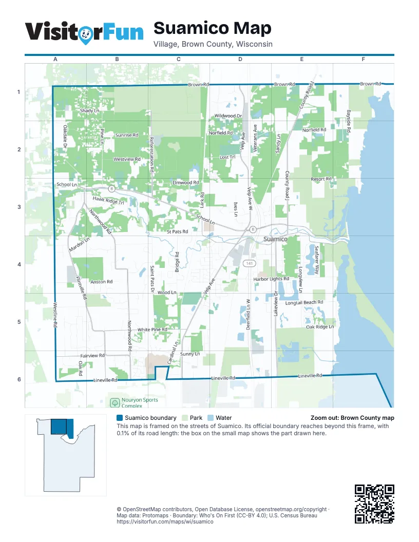
Street index of Suamico
Each street on the sheet and the grid squares it crosses.
- School LaneA3, B3, C3, D3
- Sunset Beach RoadD3, E3, E4, F4
- Velp AvenueD1, D2, D3, C4, D4, C5, C6
- Northwood RoadA3, B3, B4, B5, B6
- Brown RoadC1, D1, E1, F1
- Riverside DriveC3, E3, C4, D4, E4, F4
- Lineville RoadA6, B6, C6, D6, E6
- County Road JE1, E2, E3
- Flintville RoadA3, A4, A5, B5
- Lakeview DriveE4, E5, E6
- White Pine RoadB5, C5
- Reforestation RoadC1, C2, C3
- Fairview RoadA6, B6
- Velp Avenue WestD2, D3
- Pinecrest RoadB5, B6
- Veterans AvenueD1, D2, D3
- Norfield RoadC2, D2, E2, F2
- Harbor Lights RoadD4, E4, F4
- Deerfield Lane WestD3, D4, D5
- Pine LaneB1, B2, B3
- Bayside RoadF1, F2
- Longview LaneE3, E4, E5
- Saint Pats DriveC4, C5
- Elmwood RoadB3, C3, D3
- Oakdale DriveA1, A2, A3
- Wood LaneC4, B5
- Westline RoadA4, A5, A6
- Anston RoadA4, B4
- Resort RoadF2, E3, F3
- Deerfield Lane EastD4, D5
- Elmtree RoadA3
- Bridge RoadC3, C4
- Longtail Beach RoadE5, F5
- Wildwood DriveC1, D1, C2
- Cardinal LaneC5, C6
- Shady LaneA1, B1
- Cathedral Forest DriveA5, A6
- Westview RoadB2, C2
- Sunrise RoadB2, C2
- St Pats RoadC3
- Pine Forest DriveA2, B2
- Hawk Ridge TrailB3
- Blackberry LaneA1, B1
- Stream RoadB3
- Moose Creek TrailB5, B6, C6
- Lost TrailC2, D2
- Brook Hills DriveB4, B5
- Harbor Winds DriveE4
- Ives LaneD3
- East Deerfield AvenueD5, D6
- Wynding Ridge WayA4, B4
- Birch RoadD4
- Whippoorwill RoadB4, C4
- Oak Ridge LaneE5, F5
- Summerset CircleE4, E5
- Seafarer WayE4
- Lost Creek LaneA1, B1
- Sunny LaneC6
- Lark RoadC3
- West Deerfield AvenueD5, D6
- Wyndrush DriveE5
- Crown Pointe BoulevardE5
- Wilderness TrailA1, A2, B2
- Westpoint RoadA5
- Michelle DriveD1
- St Francis Park DriveC2, D2, D3
- Hook RoadF1
- Tarragon TrailA3, B3
- Hidden Lake LaneB4, C4
- Mardon LaneA4, B4
- Elvira WayC4, D4
- Libby LaneC3, C4
- Sandy LaneE2
- Longtail Beach LaneF5
- Hallers Creek RoadC3
- Stonegate DriveC4
- Scotch Pine TrailB4, B5
- Crown Pointe CircleE5
- Oak RoadA6
- Skyline Pines DriveA5
- Tumbleweed TrailA5
- Rainbow DriveC5, C6
- South Timber TrailE3
- Maple GroveE4
- Forest Edge DriveA5, B5
- Idlewild RoadE4
- Big Timber CircleB5
- Woodland Reserve LaneD4
- Sandy Acre CourtC3
- Woodington WayD5, E5
- Austrian LaneA6
- Susie DriveD1
- Stone Creek CircleB4, C4
- Trenton LaneD4
- Golden Bell DriveB6
- Oak Forest DriveB5, B6
- Moonlight DriveC5, C6
- Magy LaneC4
- Woodsdale StreetD4, E4
- Pink Dogwood WayB6
- Luxury DriveB5, B6
- Autumn Ridge TrailB5
- Chambers CrossingC5, D5
- Timber TrailE3
- Vince LaneC4
- Breezeway Bluff CourtC4
- North Gate RoadD5
- Mount Olive DriveC4
- Robin LaneA4
- Thorn Hill DriveB2
- Spur LaneB2
- Mourning Dove RoadE1
- Hilltop DriveD1, D2
- Rocky WayC5
- Gray Hawk TrailB3
- Mink Ranch RoadE4
- Pristine LaneA5
- Huntington WayE5
- Pirates CoveC6
- Side StreetD3, D4
- J Edward CourtA5, A6
- Meadow Heights TrailC4, D4
- Partridge LaneA2
- Celestial LaneB6
- Sandhill DriveA1
- Atterberry LaneD2
- East Weston WayD4, D5
- Sunset Beach LaneF3, F4
- Coach LaneD3
- Forest Ridge DriveB2
- South Weston WayC4, D4
- Cinnamon Ridge TrailC4
- Cedar LaneB5
- Rose Haven TrailB2
- Wisteria CircleB6
- Ranchu RoadC5
- Cottage RowF2, F3
- River Meadow DriveC4, D4
- Golden ArrowD2
- Yellow Jasmine WayB6
- Maple Grove RoadE4
- Flowering Peach DriveB6
- Cedar CourtA3, B3
- Sandburr TrailE1
- Salem LaneA4
- Rustic Haven LaneA5
- Fenmore LaneD4, D5
- Jesse LaneC5
- Harbor Lights LaneF4
- Hidden Pond RoadB3
- Hollow Valley TrailC4
- Family DriveE4
- Sassaby TrailC6
- Field CourtD4, E4
- Ancestor WayC4, D4
- Lillian LaneB5
- North Brook Hills DriveB4
- Willow WayE2, E3
- Mystic Hills TerraceB6
- Overlook CourtD4
- Flintlock RoadD3
- International TrailC2
- Cormorant LaneC4, D4
- West Tanager LaneC4, D4
- Kingfisher LaneC4, D4
- Quail LaneD4, D5
- Wandering CourtB4
- Rockwell LaneC6
- Garden LaneC6
- Siesta LaneD4
- Wheatfield DriveA3
- Crescent SquareB5
- Fescue WayD5
- Redpepper TrailC4
- Farmington WayC5, D5
- Evergreen LaneB5
- Honey Clover CourtC6
- Loxley CourtE5
- Breezewood LaneB5
- Hawks Nest TrailC4
- Forest Meadows CourtC6
- Brandy Wine DriveA4, B4
- St Francis Park CircleC2, D2
- Tower DriveA2
- Sand Dollar CourtB5
- Red Pine CourtB5
- Sarah CourtD1
- Snowshoe TrailD3, E3
- Weedy StreetC4, D4
- Clearwater DriveC3
- Country Meadow CourtC4
- Pinewood TrailD1
- High Country CourtB3
- Deer Run RoadA2
- Irish Hill EstateC5
- Parkland WayD5, E5
- Hidden Forest CourtB4, B5
- Bowling Green LaneD4
- West Kenlar CircleB4
- East Kenlar CircleB4
- Glory Sue CourtF3
- Minnie LaneC4, D4
- Autumn Wood TrailA5, B5
- Meadow Flower LaneC4
- Renard CourtE2
- Maplecrest DriveA3
- Burtons Riverside TrailD4
- Kathleen CourtD2
- Wilding WayD5
- Transfer TrailE3
- Gingerwood WayC4
- Cedar Spring CourtB5
- Cheery LaneB1
- Hallers Creek LaneC3
- Windhaven TrailC4
- Falcon Ridge TrailD4
- Ken RidgeA4
- Carolina Cherry WayB6
- Goldeneye LaneD5
- Trappers Bend CourtA3
- Pride TerraceD4
- Hawks Landing WayB3
- Gliding Hawk WayB3
- Nadiana WayB6
- Merganser LaneC4
- Bracton CourtD4
- Water Way CourtC6
- Barkhausen Waterfowl Preserve ParkingE6
- Black Powder RoadD3
- Grey Wolf CourtC5, C6
- Grassy Plains DriveA5
- Parkfield CourtD6
- Short StreetD4
- Descendant LaneC4, D4
- Huntington Way SouthE5
- Crystal Creek CourtB1
- Church Hill DriveA3
- North Lake Ridge LaneB4, C4
- Roberta CourtC5, C6
- Royal Oaks CourtD3
- Timberwood DriveD1
- Meadow WayA6
- Popplewood CourtD4
- Roundabout CourtD4
- Sagewood WayC4
- Pleasant PlaceA3
- Wellington DriveE4
- Ridge Wood CourtA5
- Knight Riders LaneC5, C6
- Longbranch TrailA5, B5
- Wild Brim CourtB4
- Mallard CourtD5, E5
- Rose Haven CourtB2
- Smokey LaneD3
- Musket DriveD3
- East Bay Breeze CourtE4
- St Pats DriveC3, C4
- Channel RoadF2
- Carriage DriveE4
- Conifer CourtC5
- South Kenlar CircleB4
- Brook Hills CourtB4
- Elderberry CourtB1
- Summer Breeze CourtC5, C6
- White Birch TrailD3, E3
- Nordic CourtD3
- Forest LaneC2
- Clover Field DriveC5, D5
- Monte Carlo CourtC5
- Quiet Wood TrailB1, C1
- Red Oak StreetA6
- Powder Horn LaneD3
- Bay Breeze CourtE4
- Westmore LaneC4
- Shilo RoadD3
- Ruby Ridge CourtB5
- Whirthington CourtE4
- Meadow Heights CourtD4
- Mulligan WayC5, D5
- Wellenfang LaneB5, B6
- Mardon CourtA4
- Lucille CourtC5, C6
- Rockbottom CourtC4, D4
- Deer Run CourtA2
- Golden Hours CourtD4
- Hawkeye CourtB3
- Tanglewood LaneE3
- Bracton RoadD4
- Ascot PlaceE5
- Suamico LaneD4
- Vulcan CourtD4
- Gossamer DriveA6
- Kaplan CourtD2
- Cotton DriveE4
- Northridge CourtB4
- Scenic Ridge CourtC4
- Carleen CourtC2, D2
- Brook Hills PlaceB4
- Southridge CourtB4
- Fescue CourtD5
Places on the map
- ALDI
- Animal Clinic of Suamico LLC
- Barkhausen Waterfowl Preserve
- Batting Cage
- Bay Harbor Elementary School
- Bay Port High School
- Boat
- Brown County Reforestation Camp
- Brown County Rifle Range
- Buzz Social
- Calavera Springs
- Children's Petting Zoo
- Country Inn & Suites
- Culver's
- Festival Foods
- Green Bay West Shores State Wildlife Area
- Green Bay West Shores Wildlife Area-Bayside Road Unit
- Green Bay West Shores Wildlife Area-Long Tail Unit
- Green Bay West Shores Wildlife Area-Sensiba Unit
- Harbor Lights Lake
- Hidden Lake
- Idlewild Park
- Kwik Trip
- Lake Jessie
- Lake Leone
- NEW Zoo
- NEW Zoo Adventure Park
- North American Aviary
- North American Plains
- Saint Benedict Cemetery
- Saint Pats Park
- Suamico River
- Suamico Town Hall
- Townline Pub & Grill
- West Shore Preserve
© OpenStreetMap contributors, Open Database License, openstreetmap.org/copyright · Map data: Protomaps · Boundary: Who's On First (CC-BY 4.0); U.S. Census Bureau















