

Wisconsin map
Town of Burlington map
About 10,939 people live here (Census Bureau, 2024 estimate). The sheet's index lists 214 streets; Burlington Bypass, Durand Avenue and Brever Road cross the most grid squares. Also on it: Bohner Lake, Bohners Lake and Browns Lake.
Open the map (PDF, US Letter)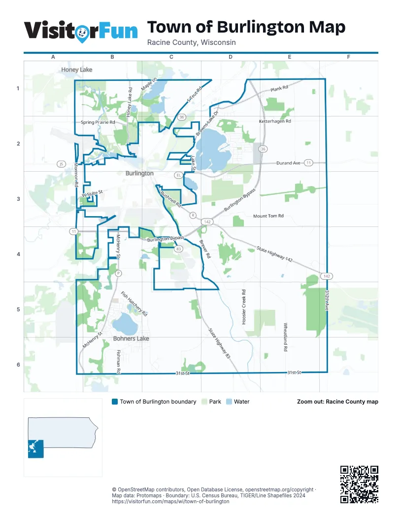
Street index of Town of Burlington
Each street on the sheet and the grid squares it crosses.
- Kildeer CourtB1, C1
- North Honey Lake RoadB1
- South Honey Lake RoadB1, B2
- South Maple LaneB1, C1
- Euphoria DriveC1
- Killdeer CourtC1
- North Maple LaneC1
- South Teut RoadC1, D1, C2
- Walton RoadC1
- Belair DriveD1
- Belaire DriveD1
- Browns Lake DriveD1, C2, D2
- Burlington BypassD1, E1, D2, E2, D3, A4, B4, C4
- Carlin CourtD1
- Casen CourtD1
- Cora CourtD1
- Emma LaneD1, D2
- Isabel LaneD1
- Jante DriveD1
- Jeffrey DriveD1
- Linden CourtD1, D2
- Mila WayD1, D2
- Old Highway AD1
- Old Spice RoadD1
- Plank RoadD1, E1
- River Knoll DriveD1, D2
- Crossway RoadE1, E2
- North River RoadE1
- North Westwood AvenueE1
- South River RoadE1
- South Westwood AvenueE1
- Waymar LaneE1
- South English Settlement AvenueF1, F2, F3
- Mormon RoadA2, A3
- West Chestnut StreetA2, B2
- Airport RoadB2
- Bieneman RoadB2
- Bienemann RoadB2
- Entrance 3B2
- Robins RunB2
- Spring Prairie RoadB2
- Travelers RunB2
- Bear Arbor DriveC2
- Cowdrey StreetC2
- Droster AvenueC2
- Korth CircleC2
- Lake StreetC2, C3
- Voss CourtC2
- Arrow DriveD2
- BeachD2
- Caldwell RoadD2
- Cedar DriveD2
- Circle DriveD2
- Cottonwood CourtD2
- Driftwood TrailD2
- Durand AvenueD2, E2, F2, C3, D3
- FairfieldD2
- Fischer DriveD2
- Forest DriveD2
- Front StreetD2
- Greenleaf DriveD2
- Hickory LaneD2
- Jennie LaneD2
- Ketterhagen RoadD2, E2
- Knollcrest DriveD2
- Lakehills DriveD2
- Landre CourtD2
- Lawn DriveD2
- Marine DriveD2, D3
- Martin TerraceD2
- Meadow DriveD2
- Moccasin DriveD2
- Mound DriveD2
- Murphy AvenueD2
- Peninsula DriveD2, D3
- Pinewood DriveD2
- Poplar DriveD2
- Red Oak DriveD2
- Shore DriveD2
- Spring DriveD2
- Sumac DriveD2
- Sunny SlopeD2
- West Pinewood DriveD2
- West Woodlawn DriveD2
- WoodlawnD2
- Rocky RoadE2
- Stoney Hill RoadE2
- Ridge RoadA3, B3
- Spring Valley RoadA3
- Voree CourtA3
- West State StreetA3, B3
- Hillside DriveB3, B6
- West AvenueB3
- Brever RoadC3, C4, D4, D5
- Bushnell RoadC3, D3
- McCanna ParkwayC3
- Weiler RoadC3, D3
- Lakeside Road WestD3
- Mount Tom RoadD3, E3
- Parkside Road NorthD3
- Spur DriveD3
- State Highway 142D3, D4, E4, F4
- Sunnyside Road EastD3
- Waters Edge CircleD3
- Bonn's TrailE3, E4
- Leo's CourtE3, E4
- Veiterhof LaneA4
- Dream StreetB4
- McHenry StreetB4, B5, A6, B6
- Oriole DriveB4
- Yahnke RoadB4, C4
- Conrad CourtC4
- Hidden Creek LaneC4
- South Pine StreetC4
- State Highway 83C4, C5, D5, D6
- Hoosier Creek RoadD4, D5, D6
- Indianwood CircleD4
- Running Fox TrailD4
- Wheatland RoadD4, D5, E5, E6
- Wild Goose LaneD4
- Young DriveD4
- Coyote CircleE4
- Horseshoe TrailE4, F4
- Shagbark LaneE4, E5
- Womack LaneE4
- 312th AvenueF4, F5
- Foxtail LaneF4
- South English Settlement DriveF4
- Big Pine LaneB5
- Cardinal TrailB5
- Cattail DriveB5, B6
- Contour DriveB5
- Curtis CourtB5
- Euclid DriveB5
- Evergreen TerraceB5
- Fish Hatchery RoadB5, C5, C6
- Fishman RoadB5, B6
- Ford DriveB5
- Franklin StreetB5
- Fulton StreetB5
- Gateway DriveB5
- Grand BoulevardB5
- Greendale AvenueB5
- Highland AvenueB5
- Hillcrest DriveB5, B6
- Honey LaneB5
- Lagoon DriveB5
- LakeviewB5
- Lynn LaneB5
- Monona CourtB5
- Monono CourtB5
- OakdaleB5
- Oakwood DriveB5
- Park StreetB5, B6
- Plainview AvenueB5
- Ridgeway DriveB5
- Robers StreetB5, C5
- Russet StreetB5
- Sage StreetB5
- Short StreetB5, C5
- South Lakeshore DriveB5, C5, B6
- South StreetB5
- Store StreetB5, B6
- Truman CourtB5
- Valley DriveB5, B6
- Walburg LaneB5
- Waveland AvenueB5
- West Lakeshore DriveB5
- White Oak DriveB5
- Bayview DriveC5, B6
- Bohner DriveC5, B6, C6
- Chara DriveC5, C6
- Schaal RoadD5, C6, D6
- Sun CourtD5
- Warren RoadA6
- 31st StreetB6, C6, D6, E6
- 392nd AvenueB6
- Buena DriveB6
- Center StreetB6, C6
- Charles StreetB6
- Clarence StreetB6, C6
- Cochran StreetB6
- Country View LaneB6
- Crestview DriveB6
- Dale StreetB6
- Fairview CourtB6
- Fern DriveB6
- Fir DriveB6
- Green StreetB6
- Heather AvenueB6
- Hilltop DriveB6
- Horizon DriveB6
- Ivy CourtB6
- Mallard DriveB6
- Maple Grove DriveB6, C6
- Morel DriveB6
- Moss RoadB6
- Palm DriveB6
- Rose StreetB6
- Steele RoadB6
- Summit PlaceB6
- Wren StreetB6, C6
- 368th AvenueC6
- 376th AvenueC6
- Clarance StreetC6
- Fieldstone CourtC6
- Juniper StreetC6
- Pheasant RunC6
- Quail RunC6
- Shady LaneC6
- Trail LaneC6
- 348th AvenueD6
- County Highway WE6
- Cramer CourtE6
Places on the map
- Alabama Lake State Habitat Area
- Beachview Grocery
- Bohner Lake
- Bohners Lake
- Browns Lake
- Burlington Cemetery
- Burlington Wetland Area
- Burlington Wetland Habitat Area
- Bushnell Park
- Cedar park
- Duckett School
- Echo Lake
- Fischer County Park
- Fischer Park
- Guthrie Fire Pit
- Herb Leach Park
- Honey Creek Wildlife Area - Long Lake Unit
- Hoosier Creek Habitat Area
- John Margis JR Wildlife Area
- Julius Aukes Beach Park
- Karcher Springs State Natural Area
- Long Lake
- Long Lake Unit
- Louis Fago Park
- Lower Spider
- Main Pit
- Mathers
- Middle Spider
- Mobil
- Mount Tom
- Park Toilet
- Pathway Church Burlington
- Red Cross Fire Pit
- Rockland Lake
- Upper Spider
- Wehmhoff Woodland Preserve
- Winkler Elementary School
- Winkler School
- YMCA Camp MacLean
Next to Town of Burlington
- Burlington map
- Honey Lake
© OpenStreetMap contributors, Open Database License, openstreetmap.org/copyright · Map data: Protomaps · Boundary: U.S. Census Bureau, TIGER/Line Shapefiles 2024















