

Wisconsin map
Town of Plover map
About 14,208 people live here (Census Bureau, 2024 estimate). The sheet's index lists 101 streets; Plover Road, Prairie Drive and Biron Drive East cross the most grid squares. Also on it: Galecke Park, Little Plover River Fishery Area and Bluebird Park.
Open the map (PDF, US Letter)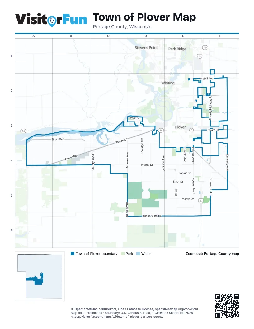
Street index of Town of Plover
Each street on the sheet and the grid squares it crosses.
- Woodland RoadF1
- Airline RoadE2
- Hoover AvenueE2, E4
- Hoover Avenue NorthE2
- Hoover RoadE2
- Iris LaneE2
- McDill AvenueE2, F2
- Porter RoadE2
- Roger's DriveE2
- Zblewski DriveE2
- Bembenek LaneF2
- Bluebird DriveF2, F3
- Brilowski RoadF2
- Cabernet CourtF2
- Canary DriveF2
- Cardinal DriveF2
- County Highway RF2, F3
- Flicker LaneF2
- Lindstrom LaneF2
- Oakwood LaneF2
- Oriole LaneF2
- Pinewood DriveF2
- Porter DriveF2
- Robin LaneF2
- Biron Drive EastA3, B3, A4
- Johnson AvenueB3, B4
- Lake DriveB3
- Hayes AvenueC3, C4
- Hayes RoadC3
- Love Creek AvenueC3, C4
- Pierce AvenueC3, C4
- Plover RoadC3, D3, F3, A4, B4, C4
- River Ridge CircleC3
- River Ridge RoadC3, C4
- Woodland CourtC3, C4
- Coolidge AvenueD3, D4, D5
- Grant AvenueD3
- Julie CourtD3
- Lila DriveD3
- Michael CircleD3
- Monroe AvenueD3, D4
- Park DriveD3
- River DriveD3
- River Height CourtD3
- River Height DriveD3
- Tall Pine DriveD3
- Black Oak DriveF3
- Clearview CourtF3
- Eisenhower AvenueF3, F4
- Kennedy AvenueF3, F4, F5
- Roosevelt DriveF3
- Saeco DriveF3
- Twin Towers DriveF3
- Water WayF3
- 80th Street NorthA4
- 84th StreetA4
- 90th Street NorthA4
- 100th StreetB4
- 100th Street NorthB4
- 110th StreetB4
- 110th Street NorthB4
- Club Forest DriveB4, C4
- Beech DriveC4
- County Road FC4
- Drake StreetC4
- Forest Lake DriveC4
- Meehan DriveC4, D4
- Prairie DriveC4, D4, E4, F4
- Buchahan AvenueD4
- Forest DriveD4
- Jackson AvenueD4, D5
- Boston DriveE4
- Cheryl's DriveE4
- Ford CourtE4
- Gil's DriveE4
- Hoover Avenue SouthE4, E5
- Lincoln AvenueE4
- Old So White RoadE4
- Pine Tree AvenueE4
- Pleasant DriveE4, F4
- Poplar DriveE4
- State Highway 54E4, F4
- Taft RoadE4, E5, E6
- 2nd StreetF4
- Barbara's LaneF4
- Bee's LaneF4
- Bonnie LaneF4
- Han's DriveF4
- Harding AvenueF4
- Isherwood RoadF4, F5, F6
- Jack's DriveF4
- Pat's CourtF4
- Shady DriveF4
- Birch DriveD5, E5, F5
- Marsh DriveD5, E5
- Townline RoadD5, D6
- Brook DriveE5
- Weller RoadF5
- Buena Vista DriveD6, E6
- Buena Vista RoadD6
- Hilmer LaneD6
Places on the map
- Best Western Plover
- Bluebird Park
- Boston School Forest
- Brooks Tractor
- Brooks Tractor - John Deere
- Brooks Tractor Inc.
- CAT Scale
- Club Forest
- Dairy
- Feltz's Dairy Store
- Galecke Park
- Kwik Charge
- Kwik Trip
- Little PLover River Barons Restoration
- Little Plover River Fishery Area
- Little Plover River Savanna Restoration
- Maine Cemetery
- McDill Cemetery
- Meehan Cemetery
- Prairie Drive
- Runway Leasing Incorporated Number 2 Airport
- Shooter's
- Super 8
Next to Town of Plover
- Park Ridge
- Plover map
- Stevens Point map
- Whiting
© OpenStreetMap contributors, Open Database License, openstreetmap.org/copyright · Map data: Protomaps · Boundary: U.S. Census Bureau, TIGER/Line Shapefiles 2024















