

Wyoming map
Albany County map
About 39,288 people live here (Census Bureau, 2024 estimate). The sheet's index lists 300 streets; Dwight D. Eisenhower Highway, US Highway 30 and State Highway 230 cross the most grid squares. Things to do inside the boundary: Laramie and Medicine Bow National Forest.
Open the map (PDF, US Letter)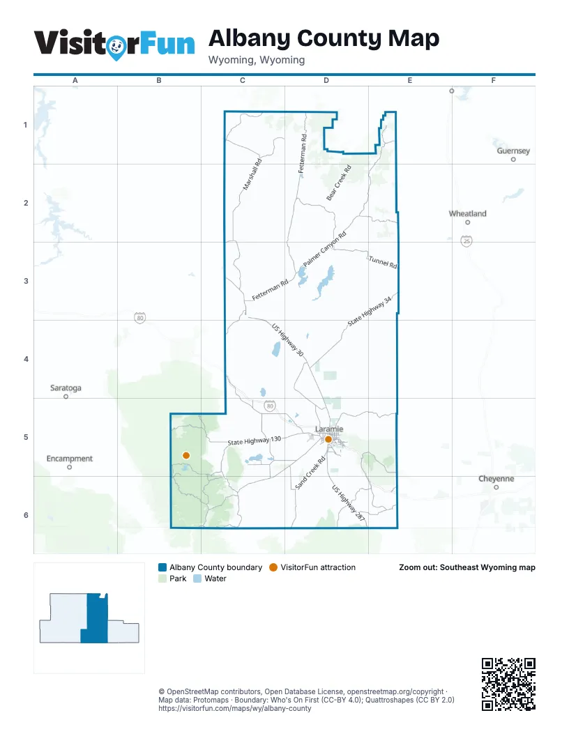
Maps inside Albany County
1 map inside, from the street map of Albany County down.
Street index of Albany County
Each street on the sheet and the grid squares it crosses.
- Dwight D. Eisenhower HighwayC4, C5, D5, D6, E6
- US Highway 30C3, C4, D4, D5
- State Highway 230C5, D5, B6, C6
- US Highway 287D5, D6
- State Highway 34D3, E3, D4
- East Grand AvenueD5
- West Curtis StreetD5
- North 3rd StreetC3, D5
- Snowy Range RoadD5
- South 3rd StreetC3, D5
- North 4th StreetC3, D5
- East Curtis StreetD5
- South 5th StreetC3, D5
- Jackson StreetD5
- North Highway 287D6
- State Highway 130B5, C5, D5
- Herrick LaneC5, D5
- Happy Jack RoadD5, E5
- State Highway 11C5
- State Highway 13C3, C4
- Soldier Springs RoadD5
- Skyline RoadD5
- Reynolds StreetD5
- East Harney StreetD5
- North 15th StreetD5
- North 30th StreetD5
- South 15th StreetD5
- North 9th StreetD5
- Spring Creek DriveD5
- McCue StreetD5
- South 9th StreetD5
- North Pierce StreetD5
- Russell StreetD5
- General Brees RoadD5
- South Pierce StreetD5
- South 30th StreetD5
- Old Highway 130D5
- Happy Jack Road / Old US Highway 30D5
- Fetterman RoadD1, D2, C3, D3
- Marshall RoadC1, C2, C3
- Palmer Canyon RoadD2, E2, D3
- Sand Creek RoadD5, D6
- Cottonwood Park RoadE1, D2, E2
- Tunnel RoadD3, E3
- Roger Canyon RoadD5, E5
- Garrett RoadD2, D3
- Two Rivers RoadD4, D5
- Platte River Access RoadB6, C6
- Little Medicine RoadC1
- Dutton Creek RoadC4, C5
- Monument RoadE6
- French Creek RoadB5, C5, C6
- Dry Park RoadC6
- Holiday RoadC1
- Boswell RoadC6
- State Highway 10C6
- Pumpkin Vine RoadD6, E6
- Hermosa RoadD6, E6
- Harris Park RoadE1
- Fox Creek RoadC5, C6
- Welsh LaneD5
- Pahlow LaneC5, D5
- Mandel LaneC5
- Cherokee Park RoadD6
- Brubaker LaneD5, D6
- Horse Creek RoadB5, B6
- Big Hollow RoadC5
- Hanson LaneC5
- Sand Lake RoadB5, C5
- Howe RoadD5
- Old US Highway 30D5, D6, E6
- Harmony LaneC5, C6
- Lake Hattie RoadC5
- Old US Highway 30 EastD5
- East Garfield StreetD5
- Muddy Mountain Cut Off RoadC5, C6
- North Buford RoadE6
- Bill Nye AvenueD5
- 9 Mile RoadC2, C3
- Fort Sanders RoadD5
- East Sheridan StreetD5
- Hunt RoadC5
- North 22nd StreetD5
- Corthell RoadD5
- Vista DriveD5
- Willett DriveD5
- Boulder DriveD5
- Old Fort Fetterman RoadD1, D3
- South Adams StreetD5
- Beaufort StreetD5
- Pilot Peak RoadD5
- South 2nd StreetC3, D5
- Cottonwood DriveD5
- East Ivinson AvenueD5
- South 4th StreetC3, D5
- South Colorado AvenueD5
- East Shields StreetD5
- Huron StreetD5
- South 17th StreetD5
- Grays Gable RoadD5
- North Cedar StreetD5
- Boswell DriveD5
- East Lewis StreetD5
- North 2nd StreetC3, D5
- East Flint StreetD5
- Sage DriveD5
- Beech StreetD5
- East University AvenueD5
- East Clark StreetD5
- Valley View RoadD5
- South Cedar StreetD5
- Venture DriveD5
- Inca DriveD5
- South 22nd StreetD5
- West Garfield StreetD5
- Bluebird LaneD5
- 26th StreetD5
- Glacier StreetD5
- West Clark StreetD5
- Blackfoot StreetD5
- West Flint StreetD5
- Cold Springs RoadC1
- North County Road 103C6
- Roach RoadC6
- North County Road 89D6
- Road 210E6
- Remount RoadE6
- Sybille RoadE3, D4, E4
- Bear Creek RoadD1, D2
- Esterbrook RoadD1, D2
- Mule Creek RoadC1, C2, D2
- Ehlin RoadB5, C5
- Sportsman Lake RoadD6
- King Mountain RoadD4, E4, D5
- Douglas Creek RoadB5, B6
- Spruce Gulch RoadB6, C6
- Sheep Creek RoadC2
- Pelton Creek RoadB6
- River Ranch RoadD5
- Fletcher Park RoadE2
- Bull Mountain RoadC6, D6
- Wild Horse Ranch RoadC5
- Vedauwoo Glen RoadE5, E6
- Blair-Wallis RoadD5, E5
- Boulder Ridge RoadD6
- Toltec RoadD1
- Eagle Rock RoadD5, E5
- Byerly DriveC2, C3
- Hay Creek RoadD2
- Telephone RoadE5
- Potato Creek RoadD2
- Gyp Quarry RoadC6
- Man O War DriveC2, C3
- Carroll Lake RoadD4, D5
- Sugarloaf RoadD2
- Old State Highway 13C3, C4
- Sheep Mountain RoadC5, C6
- Keystone RoadC5, B6, C6
- McGill LaneC5
- Millbrook RoadC5
- Jelm Mountain RoadC6
- Stevenson RoadD6
- Halleck Canyon RoadE3
- Usfs Road 633E1
- Barber Lake RoadB5, C5
- Pascoe Ranch RoadD4
- Arapahoe TrailD2
- Jonathon Quarry Haul RoadD4
- Katie Canyon LoopD5
- Cinnabar Park RoadB5, C5
- Fallen Pines RoadC5
- Kite Ranch RoadD3
- Caretaker RoadE5
- Headquarters RoadE5
- Goverment Springs RoadE2
- Ace 44 Ranch RoadC5
- Cooper Cove RoadC4
- Red Rock TrailE2
- Deer Crossing RoadD6
- Elk Creek RoadB5
- Klondike RoadE6
- Sunshine DriveD3
- Fs 683E1
- Thunder DriveD3
- Warrens Ranch RoadD5
- Gilmore Gulch RoadD5
- Dinwiddie RoadC5
- Shimmerhorn RoadE6
- Little North Fork RoadB5, C5
- Woolf Ranch RoadC4, C5
- Lakeside DriveC5
- Sprague LaneD5
- Prospect Mine RoadD1
- Neptune RoadE2
- Haystack Peaks RoadE1
- Dalles LaneC5
- Home Rock RoadD6
- Gravel Pit RoadB5
- Wall Canyon RoadD4
- Daybreak DriveD3
- Luman Carrie TrailE2
- Eagle Spur RoadC6
- Labonte Canyon RoadD1
- Wayside RoadD4
- Towner Lake RoadB5
- Flag RoadD5
- Mountain Home RoadB6, C6
- Vale Ranch RoadD3
- Davis ParkwayE6
- Government Peak RoadE3
- Mason LaneC5, C6
- Lake Owen Campground RoadC6
- Clemons Ranch RoadE3
- Sodergreen RoadC6
- Honey Tree LoopD6, E6
- Windmill Ranch RoadC5
- Gates Creek Ranch RoadD4
- Boy Ridge RoadC4
- Lake Creek Resort RoadB6
- Lewis RoadC6
- BLM 3431C6
- Bitterroot RoadD5, D6, E6
- Sir Barton LaneC2
- Thornton LaneC3
- Dodge RoadD3
- North Gramm RoadC6
- Ione RoadD4
- Ashley Creek RoadE2
- Ironhorse RoadE6
- Deerwood RoadC5
- South Albany Peak RoadE2
- Sycamore DriveD3
- Trailblazer RoadC5
- Loop RoadD3
- Gelding RoadC5
- Green Mountain RoadE2
- Cook Ranch RoadC4, D4
- Cow Camp RoadE2
- Mountain Air DriveD5
- North Fork RoadC5
- Overlook RoadD5
- Devils Pass RoadD1
- West Soldier Creek RoadE1
- Stagecoach RoadC5
- Showshoe DriveD3
- Camp Carey RoadE5
- West Vedauwoo RoadD6, E6
- Watson RoadC6
- Buford RoadE6
- Cypress WayD3
- Round Top RoadD3
- Hart RoadD5
- Gabrielson LaneC5
- Starting Gate RoadC2
- Forbes LaneC5
- Branding Iron CourtC5
- Jackrabbit Canyon DriveD5
- Brooklyn Lake RoadB5
- Pope Springs RoadD5
- Roaring Fork RoadD1
- Bold Venture RoadC2, C3
- Elk Ridge RoadD6
- East North Fork RoadC5
- Ridgeline DriveC5
- Banzhaf LaneC3
- Wind River RoadD5
- Lone Tree RoadE6
- East Park AvenueD5
- Cow Creek RoadD2
- Whispering Ridge RoadC5
- Stallion StreetC5
- Butte LoopD6
- Fox Hill RoadB6
- Lake Hattie Vistas DriveC5
- Cottonwood Creek RoadE1
- Paradise Valley RoadD5
- Howerton RoadD6
- Duck Creek RoadE2
- Cow TrailD5
- Asphalt LaneD5
- Ryff RoadD5
- Cattle DriveD4
- Horseshoe RoadE1
- Pole Creek RoadD5, E5
- Elk Crossing RoadD6
- Tamerack DriveD3
- Hornsby RoadD5
- Horseshoe Creek RoadE1
- Trail RoadE3
- Weber Creek RoadC5
- Antelope Ridge LoopD5
- Banyon WayD3
- Pegasus DriveC2
- Meeboer RoadC5
- La Bonte Canyon RoadD1
- Croonberg TrailC5
- Chimney Lamp RoadD5
- Powderhorn DriveC5
- Chokecherry Creek RoadC5
- West Pilot Hill RoadD5
Things to do on the Albany County map
Places on the map
- Albany
- Bamforth National Wildlife Refuge
- Caldwell Lake
- Cavender Reservoir
- Chimney Park Nordic Trails
- Cooper Lake
- Creighton Lake
- Downtown Laramie
- Dutton Creek Reservoir
- Fox Run Golf Course
- Gelatt Lake Public Access Area
- Happy Jack Winter Trails
- Howell Lake
- Hutton Lake
- Hutton Lake National Wildlife Refuge
- Jacoby Golf Course
- Jacoby Ridge Rural Trail
- James Lake
- Kafka Number 1 Reservoir
- Knadler Lake
- Lake Hattie
- Lake Hattie Reservoir
- Lake Mildred
- Lake Owen
- Laramie
- Laramie Landfill
- Laramie River
- Lookout Lake
- Lunch Lady
- Medicine Bow-Routt National Forest
- Meeboer Lake
- Mortenson Lake
- Mortenson Lake National Wildlife Refuge
- Pilot Hill Recreation Area
- Pilot Hill Wildlife Habitat Management Area
- Post Lake
- Rainey Lake
- Rob Roy Reservoir
- Rock River
- Rush Lake
Next to Albany County
- Cheyenne map
- Encampment
- Glendo
- Guernsey
- Saratoga
- Wheatland
© OpenStreetMap contributors, Open Database License, openstreetmap.org/copyright · Map data: Protomaps · Boundary: Who's On First (CC-BY 4.0); Quattroshapes (CC BY 2.0)















