

Alabama map
Scottsboro map
About 15,957 people live here (Census Bureau, 2024 estimate). The sheet's index lists 300 streets; John T Reid Parkway, South Broad Street and Veterans Drive cross the most grid squares. Things to do inside the boundary: Unclaimed Baggage.
Open the map (PDF, US Letter)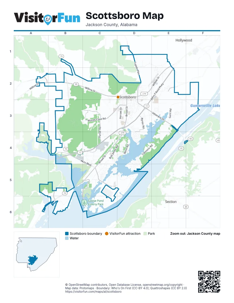
Street index of Scottsboro
Each street on the sheet and the grid squares it crosses.
- John T Reid ParkwayD2, E2, C3, D3, B4, C4
- South Broad StreetD2, D3, C4, D4, B5, C5
- Veterans DriveD2, D3, E3, E4
- Byron RoadD3, D4
- Akzo BoulevardB4, C4, C5
- West Willow StreetA2, B2, C2, D2
- East Willow StreetE1, D2, E2
- Bynum StreetD2
- Woods Cove RoadC3, D3
- Porter RoadC3, B4, C4
- Tupelo PikeD1, D2
- Ed Hembree DriveB5, C5, B6, C6
- Goosepond DriveC5
- Plantation Pointe RoadA3, A4
- County Road 33E2
- County Road 114B5, B6
- Larkinsville RoadB1, A2
- Parks AvenueD3
- County Road 76B6
- Harvey Wilborn StreetA2
- County Road 17A2
- County Road 21D1
- Winniger RoadA2
- County Road 67E4
- Old Larkinsville RoadB1, A2, B2, C2
- Bob Jones RoadD3, C4, D4, C5
- Clemons RoadE3, D4, E4, D5
- Snodgrass RoadE2, E3, F3
- County Park RoadD3, D4
- Ridgedale RoadD1, E1, E2
- Gant RoadE3
- Winn RoadC4, D4
- Micah WayE2, D3
- Skyline Shores DriveB6
- South Scott StreetD2, D3
- July Mountain BoulevardB3, C3
- Stewart RoadC3, C4
- Crawford RoadE2, E3
- Campground CircleD4, D5
- Lookout Mt. DriveD5
- Jeffery RoadB6
- Monte Sano DriveD5
- Peninsula DriveC5
- North Shore DriveC5, D5
- Bethany DriveE2, F2, E3
- Edmonds DriveE3
- Long Hollow RoadB2
- Heroes DriveD3
- Law StreetC4
- Thomas French DriveC4
- South Market StreetD2, D3
- Hood AvenueD3
- Garden DriveD3
- South Houston StreetD2, D3
- Roseberry DriveD4
- Dick Hayes RoadC4
- Moody Ridge RoadD2, E2
- George W Adams RoadE2
- East Maple AvenueD2
- South StreetD2, D3
- East Laurel StreetD2
- South Kyle StreetD2, D3
- Goosepond Island DriveC5
- Anderson Street WestC4, C5
- Bradley StreetC4
- Kelly StreetA5, B5
- North Houston StreetD2
- McFoilton LaneE1, E2
- Cherokee RoadE3, E4
- Phillips DriveD3, E3
- Happiness DriveB3, B4
- Boy DriveC3
- East Ridge RoadD3
- Cimarron StreetD3
- Wilhelm DriveC3
- Bruce DriveD2, D4, D5
- Roberts RoadB4
- Cedar Hill DriveD2, D3
- Lonnie E Crawford BoulevardC4
- Hancock Drive WestC5
- Hancock Drive EastC5
- Scenic DriveD4
- Newport DriveD2
- Birchwood DriveD3
- Bellefonte CircleE2
- Widgeon DriveC5
- Riverview CircleD4
- Wildwood AvenueD3
- Staples LaneC2
- Barbee LaneE3
- Bella Vista DriveB3
- Hillcrest DriveD4
- Berry RoadC5
- Westlawn DriveC2
- County Road 536B3
- Joy DriveE1
- Larkin StreetD2, D3
- Adams StreetD3
- Lasone DriveC4
- Pell StreetD4
- Sumner DriveD4, D5
- West Mary Hunter AvenueD2
- West Laurel StreetD2
- South George W Adams RoadE2
- West Appletree StreetD2
- Christie DriveC3
- Country Club LaneC5
- Larry DriveD3
- Shelby DriveE3
- West Charlotte AvenueD3
- Redstone DriveD5
- Dayton DriveD3
- Mallard DriveC5
- County Road 109A2
- East Charlotte AvenueD3
- Dr Martin Luther King Jr StreetD2
- Andrew Jackson WayE3
- College StreetD3
- Dover StreetC3, D3
- Canadian DriveC5
- Anderson Street EastC4, C5
- Forrest AvenueD2
- City Park RoadD4
- Legion DriveD3
- Woodall LaneC2, C3
- Dock StreetE3
- Edgewood DriveD4
- Garland Ferry RoadD3
- Virginia AvenueD4
- Sebring DriveD2
- Judge DriveB5
- Shawnee CircleB3
- Chesapeake DriveC5
- Quincy StreetD2
- Brad StreetD4, D5
- Carter StreetE3
- Lakeshore DriveD5
- Lisa LaneC4, C5
- Owens DriveC2, B4
- Lake Pointe CircleD5
- Brown StreetD2
- McClendon DriveD1
- Gant Hill RoadD3
- Bynum AvenueD2, D3
- Warn StreetD1
- Kirby StreetD2, D3
- Bingham StreetD2, D3
- Ruth StreetD4
- Wilson StreetD2
- Highland DriveE3
- Cecil StreetD3
- Center StreetD2
- Sarah Betty LaneD3
- Ashmore LaneD3
- Walsh StreetD2
- Ridgewood DriveD2
- Petty CircleC3
- West Cloverdale RoadC3
- Law RoadC4, C5
- Hillsdale DriveC5
- Lakeside DriveC5
- Clayton Arnold RoadD1
- Floyd CircleD4
- Gentle CircleD4
- Chestnut StreetD2
- Garner StreetD4
- Dellwood CircleD3
- County Road 420B5, B6
- Blue Spring RoadA2
- McIntosh StreetE3
- Worthington StreetC3, D3
- Buchannan StreetD3
- West Maple AvenueD2
- Steelworkers RoadC5
- Gwen StreetC4
- Cumberland CircleE2
- Taylor StreetD3
- Woodland DriveD2
- Meadow Island RoadD4
- Van Buren StreetD3
- Lakewood DriveC5
- Snow DriveC5
- Dean StreetD2
- Pine Ridge RoadC4
- East Stewart RoadC4
- Talley StreetE3
- Wayne StreetC4
- Martin StreetD2
- Meadowbrook DriveD3
- Bankston StreetC3, C4
- Butler DriveC3
- Ida Moody RoadC4
- McCrary DriveE2
- Liberty LaneD3
- Benwood DriveD3
- Colonial DriveD2
- Lora StreetD3
- Oak StreetD2
- Woodfern DriveB3
- Washington CircleD3
- Courtland StreetE3
- Comm-Scope WayC4
- Commodore StreetD4
- Hembree StreetC3
- Driftwood Shores DriveF3
- Earl StreetD3
- Trail Ridge RoadE3, E4
- Monte Vista DriveB3
- Karen DriveC4
- Wimberly DriveC4
- Bob CircleD4, D5
- East Mary Hunter AvenueD2
- Big Foot RoadB4
- Beverly StreetC2, C3
- Sharon StreetC2, C3
- Sauty Bottom RoadA2
- South Andrews StreetD2, D3
- Belle Hart DriveE3
- Dredge DriveE3
- Winn Haven CircleD4
- South Hamilton AvenueD2, D3
- Abbey LaneD3, C4, D4
- Oakwood CircleD2
- Debbie DriveD5
- 200th StreetD3, E3
- Mosiac StreetE3
- Brandon StreetD4
- County Road 23B3
- Scotland DriveE2
- Green StreetE3
- Camille StreetC4, C5
- Fox Run RoadC3
- Wisteria WayD4
- River Ridge CircleE3, E4
- Fields StreetC4, C5
- Julie DriveD4
- Harley StreetC3, D3
- Rose DriveC3
- Clinton RoadD3
- Hancock RoadC5
- Howard StreetD2
- Paradise PlaceD4
- Morning Glory DriveD3
- Picadilly DriveD3
- Wall StreetE2
- Bedford StreetE3
- Sisk StreetD2
- Cunningham StreetE3
- West Peachtree StreetD2
- Pine Point RoadD4
- Montecello DriveD2
- Linwood StreetE2
- North Kyle StreetD2
- Teal DriveC5
- Willow Cove DriveC4
- Knight DriveB2
- Savory DriveC5
- Goodyear BoulevardB4
- Plantation Park LaneA3
- Thomas StreetD3
- Cotton StreetD5
- Sutton LaneD4
- West StreetD3
- East Cherry StreetD3
- Lee Hall StreetC4
- Proctor DriveD4
- Winesap StreetE3
- High StreetD2, D3
- Hancock DriveC5
- Masonic DriveD4
- Rome StreetE3
- Tipperary DriveD3
- Richard AvenueE3
- Willowchase DriveC4
- Bradford RoadC4, D4
- Mimosa LaneE2
- Marsie Ave.E3
- Childress DriveC4, D4
- Linville StreetD1
- Demarius StreetC3, C4
- Edwin StreetC4
- Webb StreetD3
- Rogers RoadE2
- Alabama AvenueD2
- Yates StreetE3
- Jonathan StreetE3
- Ponroy StreetD2
- Greenview DriveE2
- Hurt StreetE3
- Becky LaneD4
- Goldenrod DriveD3
- Jeranigan StreetD2
- Twin Oaks StreetE3
- Franklin StreetD3
- Mountain Brook DriveB3
- Lequire StreetC4
- Shrader DriveB5, C5
- Boyd StreetD4
- Tom Hodge LaneD3
- Lake View DriveD3
Things to do on the Scottsboro map
Places on the map
- 50 Taters
- Aaron's
- Advance Auto Parts
- Agape Baptist Church
- Akin's
- Americas Best Value Inn & Suites
- Badcock Home and Furnature
- Bender's Gym
- Bethany Baptist Church
- Bible Baptist Church
- Bibleway Holiness Apostle Church of Jesus Christ
- Broad Street Church of Christ
- Bynum Park
- Caldwell Elementary School
- Cedar Hill Cemetery
- Collins Intermediate School
- Goose Pond Colony Park
- Goosepond Plantation Golf Course
- Highlands Medical Center
- Jackson County Fairgrounds
- Jackson County Jail
- Jackson County Park
- Jackson Square
- July Mountain
- King Caldwell Park
- Nelson Elementary School
- Parkway Plaza
- Poorhouse Mountain
- Saint Jude Catholic Church
- Scottsboro Commons
- Scottsboro Country Club and Golf Course
- Scottsboro High School
- Scottsboro Junior High School
- Scottsboro Municipal Airport
- Scottsboro Municipal Park
- Scottsboro Quarry
- Tater Knob
- The Village on Broad Street
- Veterens Memorial Park
Next to Scottsboro
- Hollywood
- Section
© OpenStreetMap contributors, Open Database License, openstreetmap.org/copyright · Map data: Protomaps · Boundary: Who's On First (CC-BY 4.0); Quattroshapes (CC BY 2.0)















