

Alabama map
Huntsville map
About 230,402 people live here (Census Bureau, 2024 estimate). The sheet's index lists 97 streets; Wall Triana Highway, Memorial Parkway Southwest and Ardmore Highway cross the most grid squares. Things to do inside the boundary: U.S. Space & Rocket Center.
Open the map (PDF, US Letter)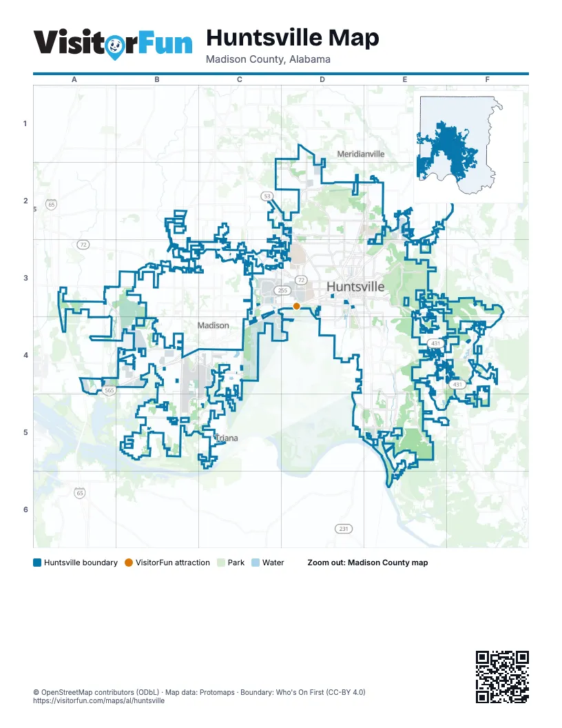
Street index of Huntsville
Each street on the sheet and the grid squares it crosses.
- Old Railroad Bed RoadB2, B3
- Ardmore HighwayC2, D2, D3
- Blake Bottom Road NorthwestC2
- Wall Triana HighwayC2, C3, C4, C5
- Bob Wade Lane NorthwestD2
- Bob Wade Ln NWD2
- Dr Martin Luther King, Jr. ExpresswayD2
- Frontage RoadD2, C3, D3
- Medaris Road NorthwestD2
- Memorial Parkway NorthwestD2, E2, D3
- Northern BypassD2, E2
- Pulaski PikeD2
- Pulaski Pike NorthwestD2, D3
- Research Park BoulevardD2, D3
- Winchester Road NorthwestD2, E2
- Homer Nance RoadE2
- Jordan RoadE2
- Moores Mill RoadE2, E3
- Northern Bypass Eastbound Lanes (Planned)E2
- Winchester Road NortheastE2
- Greenbrier ParkwayA3, B3, B4
- Mooresville RoadA3
- County Line RoadB3, B4, B5
- Huntsville Brownsferry RoadB3
- US Highway 72B3
- Bradford Drive NorthwestC3, D3
- Capshaw RoadC3
- Jeff Road NorthwestC3
- Oakwood Road NorthwestC3, D3
- Old Madison Pike NorthwestC3, D3
- Old Monrovia Road NorthwestC3
- Providence Main Street NorthwestC3
- Research Park Boulevard NorthwestC3, D3
- Slaughter RoadC3, C4
- University Drive NorthwestC3, D3
- Access Road SouthwestD3
- Adventist Boulevard NorthwestD3
- Andrew Jackson WayD3, E3
- Andrew Jackson Way NortheastD3, E3
- Bob Wallace Ave SouthwestD3
- Bob Wallace Avenue SouthwestD3, E3
- East Side SquareD3
- Governors DriveD3
- Governors Drive SoutheastD3, E3
- Governors Drive SouthwestD3
- Holmes Avenue NortheastD3
- Holmes Avenue NorthwestD3
- Jefferson Street NorthD3
- Jefferson Street SouthD3
- Jordan Lane NorthwestD3
- Jordan Lane SouthwestD3
- Madison StreetD3
- Memorial Parkway SouthwestD3, D4, E4, E5
- Memorial Parkway Southwest North Frontage RoadD3, D4, E4
- Memorial Parkway Southwest South Frontage RoadD3, D4, E4
- Patton Road SouthwestD3, D4
- Pratt Avenue NortheastD3
- Pratt Avenue NorthwestD3
- Research Park Blvd NorthwestD3
- Rideout RoadD3, D4
- Rideout Road NorthwestD3
- South Side SquareD3
- Sparkman Drive NorthwestD3
- Washington Street NortheastD3
- Washington Street NorthwestD3
- Washington Street SoutheastD3
- West Side SquareD3
- Whitesburg Drive SouthD3, E3, E4
- Bob Wallace Avenue SoutheastE3
- California Street SoutheastE3
- Moores Mill Road NortheastE3
- US Highway 72 EastE3
- Glenn Hearn BoulevardB4, C4
- Glenn Hearn Boulevard SouthwestB4
- Greenbrier Parkway NorthwestB4
- James Record Road SouthwestB4, C4
- Madison BoulevardB4, C4
- Old Highway 20B4
- Swancott RoadB4
- Martin Road SouthwestC4
- Town Madison BoulevardC4
- Zierdt RoadC4, C5
- Airport Road SouthwestD4, E4
- Martin RoadD4, E4
- Airport Road SoutheastE4
- Bailey Cove Road SoutheastE4, E5
- Carl T Jones Drive SoutheastE4
- Cecil Ashburn Drive SoutheastE4
- Four Mile Post Road SoutheastE4
- Old Hwy 431E4, F4
- Sutton RoadE4
- Eastern BypassF4
- Little Cove RoadF4
- Beadle LaneC5
- Fisher Street SouthwestE5
- Green Cove Road SoutheastE5
- Hobbs Island Road SoutheastE5, E6
Things to do on the Huntsville map
Places on the map
- Addison Park
- Aerojet Rocketdyne
- Alabama A&M University
- Aldridge Creek Greenway
- Amazon Fulfillment Center HSV1
- Amazon Fulfilment Center
- Anslee Farms
- Arch Street Apartments
- Ashbury Woods Apartments
- ATI Metals
- Auto Terminal
- BASF Catalysts
- Bates Circle Northeast
- Big Cove Creek Greenway
- Blevins Gap Preserve
- Bluewater Huntsville Quarry
- Brahan Spring Park
- Bridge Street Town Center
- Bridgewater Landing
- Brookdale Jones Farm
- Buffalo Rock
- Burgundy Square Apartments
- Burritt on the Mountain
- Campus 805
- Carriage Station
- Cavalry Hill
- Chadwick Pointe PH 1
- Chadwick Pointe PH 3
- Columbia High School
- Cooper Marsh
- Cottages at Oak Grove Dairy
- Country Club Apartments
- Country Club Estates
- Country Club Park
- Creekwood Park
- Crestwood Medical Center
- Cummings Research Park
- Ditto Landing
- Dunlop Tire
- Dunlop Tire Proving Grounds
Next to Huntsville
- Madison
- Meridianville
- Triana
© OpenStreetMap contributors (ODbL) · Map data: Protomaps · Boundary: Who's On First (CC-BY 4.0)