

Alabama map
Jackson County map
About 53,780 people live here (Census Bureau, 2024 estimate). The sheet's index lists 300 streets; John T Reid Parkway, Main Street and County Road 8 cross the most grid squares. Things to do inside the boundary: Russell Cave National Monument and Unclaimed Baggage.
Open the map (PDF, US Letter)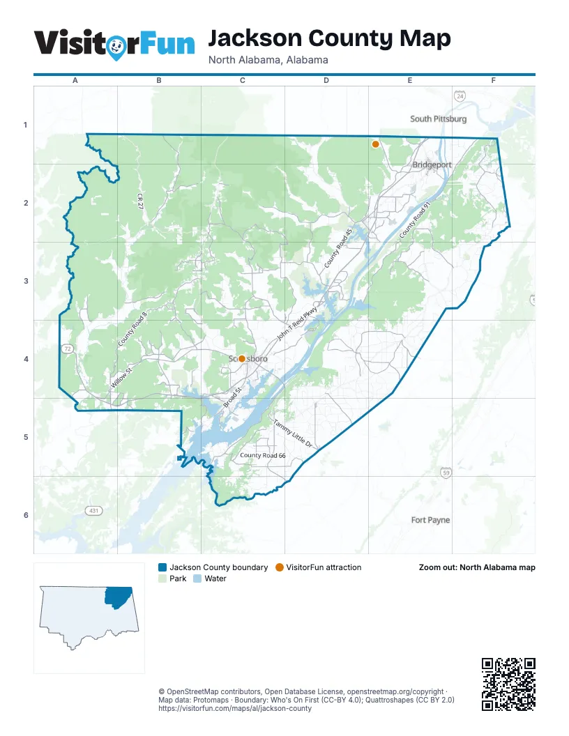
Maps inside Jackson County
1 map inside, from the street map of Jackson County down.
Street index of Jackson County
Each street on the sheet and the grid squares it crosses.
- John T Reid ParkwayE1, D2, E2, D3, A4, B4, C4, D4, A5, B5, C5
- Tammy Little DriveC5, D5
- South Broad StreetC4, C5
- Veterans DriveC4
- Lee HighwayD3, A4
- County Road 137D3
- Byron RoadC4
- Akzo BoulevardC4, C5
- County Road 230D3
- County Road 136D3
- Rowe Gap RoadC1
- Scottsboro HighwayB5
- West Willow StreetA4, B4, C4
- Alabama Highway 73F1, F2
- County Road 89F2
- East Willow StreetC4
- Main StreetD2, D3, C4, D4, D5
- East 2nd StreetD2, E2
- County Road 5A4, A5
- County Road 63A4, A5
- County Road 90F2
- Willow StreetA4, A5
- Kentucky AvenueD2, E2
- West Main StreetD2
- Francisco RoadB1
- Bynum StreetE2, C4
- Cathedral Caverns HighwayA5
- County Road 33C2, C3, C4, D4
- County Road 8B3, A4, B4, A5, B5
- County Road 91F1, E2, F2, E3
- County Road 42C3, D3, D4
- County Road 88D4, E4
- County Road 67C4, C5
- County Road 14E2, E3, F3
- County Road 53C2, D2
- County Road 39C2, D2, C3, D3
- County Road 17B3, B4
- County Road 58D4, E4
- County Road 107C2, B3, C3
- County Road 21B3, C3, C4
- County Road 38C5, D5
- County Road 9B2
- County Road 75E2
- County Road 45D2, D3
- County Road 140B1, B2
- County Road 83D4, E4
- County Road 491D3, E3
- County Road 30A4, B4
- County Road 81E3
- Bellefonte RoadC3, D3, D4
- Larkinsville RoadB4, C4
- County Road 43C5, C6, D6
- County Road 96E2
- County Road 265C5
- Woods Cove RoadC4
- County Road 20B3
- County Road 47D5
- Porter RoadC4
- County Road 55D2, D3
- County Road 32C3
- County Road 98E1, E2
- County Road 59D4, D5
- County Road 74E1, E2
- County Road 145B3, B4, C4
- County Road 11B4
- County Road 70E2
- Tupelo PikeC4
- County Road 119B4
- County Road 114B5, C5
- County Road 245C2
- County Road 46D3
- County Road 116D3
- County Road 10A3, A4
- County Road 1A3, A4
- Langston Gap RoadC5
- County Road 337C5
- County Road 31C3
- 6th StreetE1, E2
- County Road 174E3
- County Road 260E4
- County Road 141D3
- County Road 154C5
- Ed Hembree DriveC5
- County Road 102C3, C4
- County Road 113D3, D4
- County Road 101B4
- County Road 213D3
- County Road 80B4
- Main Street SouthC5
- County Road 6B5
- County Road 37C5
- County Road 94E2
- County Road 134E4
- County Road 25B3, C3
- County Road 209E1
- County Road 77B5
- Goosepond DriveC5
- County Road 143B3, C3
- County Road 412D3
- County Road 470C3
- Jacobs AvenueE1, E2
- County Road 82B4
- Plantation Pointe RoadB4
- County Road 144C2
- McMahon Cove RoadD2, E2
- County Road 85E2
- County Road 287D2, E2
- Old Mt Carmel RoadD2, E2
- County Road 540B4
- Jerico RoadE2
- County Road 274E2
- County Road 321C4
- 8th StreetE1, E2
- County Road 243C2
- County Road 272E2
- County Road 15B3
- Main Street NorthC5, D6
- 7th StreetE1, E2
- County Road 250C2
- County Road 84B4
- County Road 7A4, B4, A5
- Alabama AvenueE2, C4
- County Road 261E2
- County Road 264C3
- County Road 219C3
- County Road 317B3, B4
- Broadway AvenueE1, E2
- East Main StreetD2
- County Road 112B4
- County Road 278E2
- Langston RoadC5
- County Road 64C3
- Lewis Payne DriveE2
- County Road 110B4
- Evans Cove RoadA5
- Mc Mahan Cove RoadD2, E2
- Russell PikeD2
- Moore AvenueE1, E2
- Parks AvenueC4
- County Road 541B4
- Harvey Wilborn StreetB4
- County Road 76B5, C5
- County Road 50D3
- Market StreetC4, D4
- Rocky Springs RoadE1
- County Road 226B4, B5
- County Road 539B4, B5
- Spring StreetD2, D3, D4
- College RoadD5
- County Road 537B5, C5
- Lois LaneE2
- Winniger RoadB4
- Central RoadE4
- County Road 268E2
- Bank StreetE2
- South Sauty RoadC5
- Bellefonte AvenueD4
- Hogjaw Valley RoadE2
- Swearengin RoadB5
- County Road 54C1, C2, D2
- County Road 19D4, D5
- County Road 3A2, B2
- County Road 44C5, C6
- County Road 4A2, A3, B3
- County Road 175B1, B2
- County Road 28C3
- County Road 123D4, D5
- County Road 66C5, D5
- County Road 160D5, E5
- County Road 158D2, E2
- County Road 326E3, F3
- County Road 131F2
- CR 27B2
- Old Larkinsville RoadB4, C4
- County Road 120D5
- County Road 124D4
- County Road 61D4, E4
- County Road 60D4, E4
- County Road 151E4
- Bob Jones RoadC4, C5
- County Road 322D4, E4
- County Road 49C5, C6
- County Road 138B2, B3
- County Road 170D1, D2
- County Road 93F1, F2
- County Road 95F2, F3
- County Road 155D2, D3
- County Road 395D5
- Clemons RoadC4, C5
- County Road 414E2
- County Road 51D5
- Scenic DriveC4, D4, C5
- County Road 56C1, D1
- County Road 97E3, F3
- County Road 105C3, C4
- County Road 378D4
- Snodgrass RoadC4, D4
- County Road 126E4
- County Road 111C3
- County Road 359D4
- County Road 18D4, D5
- County Road 78E3, E4
- County Road 62D4, C5, D5
- County Road 48C5, D5
- County Road 22D4, D5
- County Road 169D3
- County Road 162E4, E5
- County Road 147D2
- County Road 24D4
- County Road 36D3
- County Road 104E2
- County Road 290F2
- County Road 189E1
- County Road 148D2
- County Road 258D2, E2
- County Road 220C4
- Steam Plant Access RoadE2
- County Road 194F1, F2
- County Road 318F2
- County Road 474C6
- County Road 818F2
- County Road 142B2
- County Road 92F2
- County Park RoadC4
- Knotts LandingE2
- County Road 382D4, E4, E5
- County Road 127E3, E4
- County Road 186D4
- Lakeshore DriveC5
- Godwin Point RoadC5
- County Road 372D5
- County Road 354E4
- County Road 547B1
- County Road 262F2
- Sauty Bottom RoadB4
- County Road 115C6
- County Road 678E1, F1
- County Road 425D4, E4
- County Road 259F1, F2
- County Road 676E2
- County Road 368D5
- County Road 422E4, E5
- County Road 121D5
- County Road 320F2
- County Road 357D3, D4
- County Road 118E3, F3
- County Road 531C4
- Ridgedale RoadC4
- Church StreetD2, A4, C4, D4, C5
- Gant RoadC4
- County Road 125E4, E5
- County Road 206E1
- Chisolm AvenueE1, E2
- County Road 369D4
- County Road 473D5
- County Road 128E3
- County Road 239C3
- Winn RoadC4
- County Road 516B2
- Micah WayC4
- County Road 330E3, E4
- County Road 122D5
- County Road 384D4
- County Road 257F1
- County Road 216A4, B4
- County Road 339E3, E4
- County Road 497E3
- County Road 57D4
- County Road 183A4, B4
- County Road 244B2, C2
- County Road 291F2
- County Road 267F2
- Lake BoulevardB5
- Skyline Shores DriveC5
- South Scott StreetC4
- July Mountain BoulevardC4
- County Road 681E3
- County Road 152C6
- County Road 390D4
- County Road 289F2
- Stewart RoadC4
- Cynthia LaneC6
- Hytop RoadC2
- County Road 197F3
- County Road 332E3, E4
- County Road 156D5
- County Road 34C3
- Davis Ferry LaneC5
- Crawford RoadC4
- County Road 611C6
- County Road 52D5, D6
- Evans RoadC5
- Junction 500A4
- County Road 530B4
- County Road 361E4
- County Road 159F1, F3
- Venson StreetA4
- County Road 255E2
- County Road 391C5, D5
- County Road 201C2
Things to do on the Jackson County map
Places on the map
- Bridgeport
- Bynum Park
- Cedar Hill Cemetery
- Crow Creek Refuge
- Crow Creek Wildlife Management Area
- Dutton
- Fern Cave National Wildlife Refuge
- Fort Harker
- Goose Pond Colony Park
- Goosepond Plantation Golf Course
- Guntersville Lake
- Highlands Medical Center
- Hollywood
- Hytop
- Jackson County Jail
- Jackson County Park
- Jackson Square
- James D. Martin Skyline Wildlife Management Area
- Langston
- Mud Creek Wildlife Managment Area
- Nature Trail
- North Jackson High School
- North Sauty Refuge
- Northshore Campground
- Paint Rock
- Pisgah
- Pleasant Groves
- Raccoon Creek Wildlife Managment Area
- Russell Cave National Monument
- Sauta Cave National Wildlife Refuge
- Scottsboro
- Scottsboro High School
- Scottsboro Landfill
- Scottsboro Quarry
- Section
- Skyline
- Stevenson
- Stevenson Municipal Park
- Widows Creek
- Woodville
Next to Jackson County
- Fort Payne map
- South Pittsburg
© OpenStreetMap contributors, Open Database License, openstreetmap.org/copyright · Map data: Protomaps · Boundary: Who's On First (CC-BY 4.0); Quattroshapes (CC BY 2.0)















