

Arkansas map
Independence County map
About 38,345 people live here (Census Bureau, 2024 estimate). The sheet's index lists 300 streets; Heber Springs Road, North Central Avenue and Batesville Boulevard cross the most grid squares. Things to do inside the boundary: Ozark Gateway Region.
Open the map (PDF, US Letter)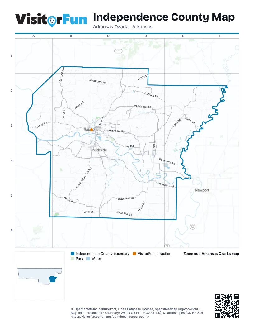
Maps inside Independence County
1 map inside, from the street map of Independence County down.
Street index of Independence County
Each street on the sheet and the grid squares it crosses.
- North Central AvenueB1, B2, B3, C3
- Harrison StreetC3, D3, D4
- Batesville BoulevardC3, C4, C5, C6
- North Saint Louis StreetC1, C2, C3
- Heber Springs RoadB3, C3, A4, B4, C4
- Point Ferry RoadD4, E4, E5
- Mountain View RoadA3, A4, B4
- White DriveB3, C3
- Harrison Street AnnexC3, D3
- West BroadwayD3
- South Saint Louis StreetC3
- Main StreetB2, D3, D5
- South Main StreetC1, D4
- Barnett DriveC3
- Heber Springs Road NorthA4
- Cord RoadE2, E3, D4, E4
- Newport RoadC4, D4, D5, E5
- Camp Tahkodah RoadB4, C4, B5
- Blackland RoadC5, D5
- Floral RoadA5, B5, C5
- Gap RoadC3, C4, D4
- Locust Grove RoadB4, C4
- Elgin RoadE3
- East Main StreetC3
- Allen Chapel RoadC3, C4
- North Locust StreetD4
- Sunny Dale RoadC6
- East Boswell StreetC3
- Mack StreetC3
- North MainD3, D5
- 6th Street WestD4
- East Midwest LaneC3
- West Main StreetB3, C3, D5
- South Central AvenueC3
- Triangle LaneC3
- General StreetC3
- 6th Street EastD4
- West Broadway StreetD3
- State Highway 14E5
- Bethesda RoadB2, B3
- Antioch RoadC2, D2, E2
- O'Neal RoadA3
- Walnut Grove RoadE2, D3, E3
- Sunset Ridge RoadC2, D2
- North Hill StreetC3, D3, D4
- Padgett Island RoadD4
- Old Camp RoadD2, D3
- Pfeiffer RoadC2, D2, C3
- Miller Creek RoadC3
- Holcombe Cemetery RoadD3
- Jamestown RoadB3, B4
- Center Grove RoadD3, E3
- Waldrip RoadD4
- Gainsboro RoadD2, D3
- River RoadB3, C3
- McHue RoadC4
- Cason LaneC3, D3
- East Wright StreetD3
- Cleghorn Chapel RoadD3, D4
- Macdonia RoadD3, D4
- Brown Lake RoadD5
- East College AvenueC3
- Sunset RidgeD2
- Bethesda LaneA3, B3
- 20th StreetC3
- Eagle Mountain BoulevardC3
- Runway RoadC3, C4
- Misty LaneC2
- Long StreetC3, D4
- Sheley LaneD4
- 14th StreetC3, D4
- Eagle Mountain DriveC3
- Macedonia RoadD4
- South Fork RoadC4
- Lawrence StreetC3
- Indian Springs RoadC3
- Chaney DriveC3
- Jennings LaneC3
- Hill StreetD3
- Highland RoadC3
- School RoadD3
- West Ross StreetB3
- Kathy LaneC3
- Juniper DriveC3
- Harry RoadC3
- Myers StreetC3
- 30th StreetC3
- Pioneer RoadC3
- Massey LaneC3
- Dogwood DriveC3
- Highland DriveC3
- Lafferty RoadB1
- West 14th StreetD4
- Sandtown RoadB1, B2, C2
- Cedar Grove RoadD2, B5
- Meadow Lake RoadD5, E5, E6
- Union Hill RoadC5, C6, D6
- Jamestown LoopB4
- Cave Creek RoadC2, C3
- Hideout RoadC5
- Lower Lockhart RoadE2, F2, E3, F3
- Wish StreetB5, C5, B6
- Big Creek RoadB5, A6, B6
- Duck Puddle RoadE4
- Goat Neck RoadD5, E5, D6, E6
- Dusty LaneD2
- Claxton LoopB2
- Thida RoadD5, D6
- North Charlotte RoadD2, D3
- Collietown RoadA2, B2
- Departee Creek LaneD5
- Punch LaneB2, B3
- Creek RoadB5
- Chin Bend RoadE3, F3
- Earnhart RoadA3, B3
- Galloway RoadE3, D4, E4
- Coon Creek LaneC2
- Chin Springs LaneB2, C2, C3
- Shamrock LaneD2, E2
- Pine Grove RoadA4, A5, B5
- Turkey Hill RoadE2, F2
- Oak Hill LoopB2
- Upper Lockhart RoadE2, F2
- Parquette RoadD4, E4
- Blueberry RoadE2, F2, E3
- Kelley RoadA2, A3
- Wagon Wheel RoadB5
- Farm Field RoadD5, E5
- Allen RoadB2, B3
- Two Mile Creek RoadD3, D4
- Sanders RoadD3
- Buzzard Roost RoadE5
- Norris LaneD3, D4
- Old Stoner RoadD2
- Overlook DriveD6
- Pine Hill RoadB1, B2
- Cold Creek LaneC1, C2
- Forest LaneC2, D2
- Limedale RoadB3
- Peach Orchard RoadA5, B5
- Sherrill DriveC4
- Big T RoadB1, B2
- North Main StreetB2, D3, D4, D5
- Goodie Creek RoadC4, D4, C5
- Harmontown RoadA3
- Arrowhead LaneC2
- Webber Chapel RoadA3, B3
- Wildwood RoadD4
- Skyview LaneB2, C2
- Shug RoadD3
- Lone Wolf RoadD1, D2
- Rosewood RoadC3
- Circle R RoadB5, C5
- County Road 150A2, B2
- Collistown RoadA2, B2
- Lonoke LaneD3, C4
- Grace RoadA4
- Harkey RoadB3
- Watson RoadD3
- Rounds RoadC3, D3
- Mitchell RoadB3
- Melon DriveC1, C2
- Cornerstone RoadC5
- Kyler RoadB4, C4
- Red Bell LaneC1, C2
- Lock 3 RoadA2
- Weaver Chapel RoadC2
- Oak Grove RoadC4
- Hilly Village RoadC2
- Capshaw RoadC4
- Mt Herman RoadD3
- Rafter D Ranch RoadB1, B2
- Haley LaneD3
- Wire LaneC1, C2
- Finney RoadB2
- Harwood RoadD5
- West Fetzer RoadE3
- Medlock RoadA3
- Chinquapin LoopA3, B3
- Maple Springs RoadD4, D5
- Stark Springs LaneB2, B3
- Humphrey DriveC5
- Loop RoadB3, B4
- Weaver Hill RoadC4
- Biram RoadA5, B5, B6
- WPA RoadE3
- Sweet Gum RoadC2
- Pear LaneE5
- Glenwood LaneB2
- Lawrence Road 358E2, F2
- Oak Bluff RoadD2, D3
- Gill RoadA3, B3
- Crow LaneD3
- High Rock RoadB2, C2
- Old Union RoadB5
- Dry Run CircleB3
- Hughey LaneA3
- Peel RoadA4, B4
- Winchester TrailD1, D2
- Evans RoadC4, C5
- Round Mountain RoadB5
- West Hopewell RoadE3
- Hickory Flat RoadB5, B6
- McGough RoadC4
- Crossed Arrow RoadB5
- Walter D RoadC3, C4
- Thompson DriveB5
- North Vaughn StreetD3
- Reed Wade RoadC3
- Edwards Cemetary RoadE3
- Lick Creek RoadE3
- Welcome LaneC1, C2
- Miss Helen LaneE3
- Country Oak RoadB4
- Barber RoadD4
- Walden RoadE2
- Russell Ferry RoadC4
- Akron LaneD4
- Brushy RoadB4, C4
- Lawson RoadB4, B5
- Coe LaneD2, D3
- Neeley StreetC3
- Chester Thomas RoadB4, C4
- Red Cut RoadB3
- Beagle LaneC2
- Anderson Hill RoadE3
- Young RoadD3
- Mountain Ridge RoadC3
- Carter's RidgeD3
- Wilcox RoadB5, C5
- Bluff DriveA5, B5
- East Club RoadC6
- Gainer Ferry RoadB3
- Six Mile LaneD5
- Tom Williams RoadC4
- Hickerson RoadB3
- Dowdy RoadE2
- Clark LaneA2
- Lesley Hollow RoadC2
- Rooster RoadC4
- Golden TrailC1, C2
- South Flippo Chapel RoadC5, C6
- Morgan RoadC3
- Thunder Hill LaneB2
- Bone Cave LaneB3
- Benton RoadB2
- Joens LaneA2, B2
- Mount Springs RoadB3
- Jennifer T Wyatt RoadD4
- Greenbriar Farm RdB3
- Woodmont CircleC3
- Lewallen LaneE2
- Blue Creek RoadC3
- Sisk LoopD5, E5
- North Heights AvenueB3, C3
- Northwoods LaneD2
- Rolling Ridge LaneC2
- King RoadB4
- Morris AvenueC3
- Day LaneD5
- Freeze BendD5
- Brewers Hill RoadC3
- Cemetary RoadA5
- Heather LaneD3
- Berry RoadA5, B5
- Red Thomas LaneD3
- McSpadden LaneB3
- River Ridge RoadD4
- Old Trestle RoadC3
- Happy HollowB2
- Otter Lake RoadE3
- Cool Mist LaneB4
- Rush LaneB5, B6
- East Turkey Hill RoadF2
- Ginger LaneD5, E5
- Maple Heights RoadD5
- River Ridge LaneD4
- East Hopewell RoadE3
- Rocky RoadD5, D6
- North Wilson StreetD3
- Union Grove RoadB6
- Bradley LaneE2
- Country Lane RoadD3
- Stacey DriveC3
- Roy LaneD5, E5
- Morgan Creek LaneC4, C5
- North State StreetB3, C3
- Jaron Taylor RoadB3
- Swaim Hill RoadC4
- Hughes LaneD4
- Kimmer LaneB2
- Crockett RoadC2
- Neely DriveC5
- Boswell RoadB5
- Lake Hill LaneE3
- Staggs DriveB6
- Huddleston LaneC3
- Sidney StreetC3
- Taylor RoadD2, D3
- Creech RoadB4
Things to do on the Independence County map
Places on the map
- Adeline Hill
- Adler Hill
- Allen Hill
- Bailey Mountain
- Bald Knob
- Batesville
- Batesville Municipal Golf Course
- Batesville Regional Airport
- Baxter Hill
- Bell Hill
- Bill Hill
- Blue Springs Cemetery
- Bracy Mountain
- Brewer Hill
- Brooks Hill
- Caldwell Mountain
- Campground Cemetery
- Cave City Park
- Chapel Hill
- Chris Hill
- Clark Hill
- Cobb Mountain
- Cushman
- East Main Sports Complex
- Jamestown Crag
- Lake Kimberly
- Lake Unico
- Magness
- Moorefield
- Newark
- Oil Trough
- Pleasant Plains
- Riverside Park
- Southside
- Sulphur Rock
- Terry Sims Diamond Sports Complex
- The Course at Eagle Mountain
- White River
- White River Medical Center
Next to Independence County
- Newport
© OpenStreetMap contributors, Open Database License, openstreetmap.org/copyright · Map data: Protomaps · Boundary: Who's On First (CC-BY 4.0); Quattroshapes (CC BY 2.0)















