

Arkansas map
Batesville map
About 11,539 people live here (Census Bureau, 2024 estimate). The sheet's index lists 300 streets; Harrison Street, East Main Street and White Drive cross the most grid squares. Things to do inside the boundary: Ozark Gateway Region.
Open the map (PDF, US Letter)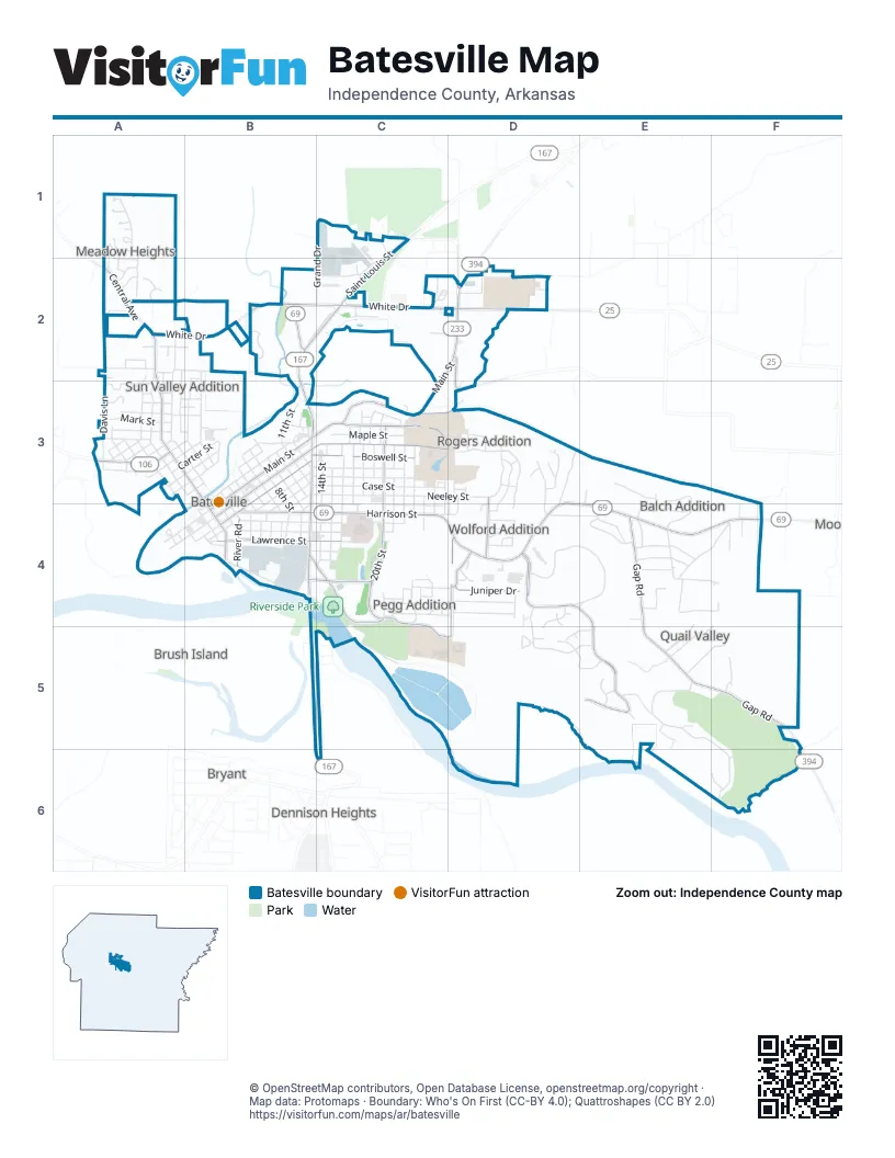
Street index of Batesville
Each street on the sheet and the grid squares it crosses.
- Harrison StreetD3, B4, C4, D4, E4, F4
- White DriveA2, B2, C2, D2
- North Saint Louis StreetC1, B2, C2, B3
- North Central AvenueA2, A3, B3, B4
- South Saint Louis StreetB3, B4
- Barnett DriveB2
- Batesville BoulevardB4
- Gap RoadE4, E5, F5
- East Main StreetC2, D2, B3, C3, B4
- East Boswell StreetB3, C3, B4
- South Central AvenueB4
- General StreetD2
- East Midwest LaneD2
- East College AvenueB3, C3, B4
- 20th StreetC3, C4
- Eagle Mountain BoulevardD4, E4, E5
- Eagle Mountain DriveD4
- Lawrence StreetB4, C4
- Chaney DriveB4, C4
- Miller Creek RoadD2, C3, D3
- Jennings LaneD4, C5, D5
- Highland RoadC3, D3
- West Ross StreetA3
- Juniper DriveD4
- Myers StreetB4, C4
- River RoadB4, C4
- 30th StreetD3, D4
- Pioneer RoadC4, C5
- Dogwood DriveD4
- Highland DriveC3
- Neeley StreetB3, C3, D3, B4
- Mountain Ridge RoadE5, F5, F6
- Woodmont CircleD4, E4
- North State StreetA2, A3, B3, B4
- Sidney StreetC3, C4
- Case StreetB3, C3
- North Heights AvenueA2, A3
- Byers StreetB3, B4, C4
- 22nd StreetC3, C4
- South BroadB4, C4
- Lyon StreetB3, C3
- Aberdeen DriveD4, D5, E5
- Bates StreetB4, C4
- Water StreetB3, B4
- Southerland DriveB4
- North Hill StreetB2, B3
- 14th StreetC3, C4
- Crest View DriveD3
- Melton DriveA1, A2
- 15th StreetC3, C4
- Porter StreetB3, C3
- Big Pine RoadE3, E4
- Quail Valley DriveE4, F4
- Whippoorwill StreetE4, F4
- Bayou StreetA3, B3, B4
- Thunderbird DriveE4, F4
- 21st StreetC3, C4
- West Main StreetA4, B4
- Davis LaneA2, A3
- Ramsey StreetB4
- Maple StreetC3
- Riverbank RoadC4, C5
- Goff DriveC4, D4
- Vine StreetB3, B4
- South 18th StreetC3
- East Craig StreetA2, B2
- 23rd StreetC3, C4
- Brooks StreetB3
- Lomond DriveD5, E5
- Addie StreetA2, A3
- Mockingbird StreetE4
- Woolridge LaneE4, E5
- Broadwater LaneA2
- Elm StreetB3
- Shade Tree DriveD4
- Pool DriveF4, E5
- Timberland DriveD4
- Hawkins StreetA3
- Arch StreetA2, A3
- College Heights DriveD3, D4
- South 17th StreetC3, C4
- Jovi DriveE4
- West Mark StreetA3
- South 9th StreetB3, B4
- North 11th StreetB3
- Sawmill RoadD3, D4
- Grand DriveC1, C2
- Dry Kiln RoadD3, D4
- West College AvenueA4, B4
- Oriole StreetE4
- East Charles StreetB3
- James StreetA1, A2
- Josephine DriveD3
- Oak StreetB3, B4
- Sunnyside DriveE5, F5
- South 19th StreetC3
- Row StreetD3
- Mill Run TrailD3
- Riverwood DriveE4
- South 8th StreetB3, B4
- Stone Flag RoadD4, E4
- West Wycough StreetA3
- Quarry B RoadC1
- Lawrence DriveC4
- Industrial DriveC2
- East Carter StreetA3, B3
- Elsie StreetA3
- Lilly StreetA3
- South 10th StreetB3
- South 7th StreetB3, B4
- Liberty LaneE4
- 24th StreetC3, C4
- West Morrow StreetA3
- Walnut Heights DriveF5
- East Chestnut StreetB3
- Ramada DriveB2, C2
- Franklin StreetC4, D4
- Edith StreetA3
- Sun Valley DriveB2, B3
- La Croix DriveD2
- Boggs StreetA3
- Parker DriveE3, E4
- Aberdeen CircleD5
- Lake Oak DriveD4, D5
- South 11th StreetB3
- Robin StreetE4
- Lee StreetC4
- West Baker StreetA3
- Wilson StreetA3
- Allen StreetB4
- Hidden Valley DriveC2
- West Pine StreetA3
- Poke Bayou LoopB2
- Betty Jean StreetC4
- Bearette StreetC3
- 26th StreetC3, C4
- Fayrene StreetA3
- Vernon DriveE4
- Iona WayD5, E5
- Reed Wade RoadD2
- Shoemaker DriveE3, E4
- County Yard RoadC2
- Shirrell LaneC2
- Virginia DriveC4
- Briar DriveC4
- South Ridge CourtE5
- Gwyn StreetC3
- East Pine StreetA3, B3
- West Boswell StreetB4
- Ridgecrest DriveD3
- Grays AvenueB4, C4
- Rock StreetB3
- East MorrowA3, B3
- Redbird DriveE4
- Hatfield DriveA2, B2
- South 5th StreetB3, B4
- South Slater StreetB4
- Pickens StreetA2, A3
- Bryant StreetD3, C4, D4
- Moss StreetD4
- 25th StreetC3, C4
- Gregg DriveA3
- Kenneth StreetA2
- Shalamar LaneF4
- Gadsen LaneB3
- Forestry LaneC2, D2
- Mark LaneC4, D4
- South 6th StreetB3, B4
- Grace StreetA3
- Alice DriveD4
- North 8th StreetB3
- Amy StreetD4
- South 3rd StreetB3, B4
- East Lawrence StreetC4
- Fairway DriveC4
- Francis StreetA1, A2
- Debra StreetD4
- Tanglewood DriveD3, D4
- Peggy StreetD4
- Dogwood Drive EastD4
- Marywood DriveB3
- North 9th StreetB3
- South 12th StreetB3
- Pioneer DriveC5
- Broad StreetB4
- State StreetB4
- Buckeye StreetC2
- Chester StreetA2
- Bluffview DriveD3, D4
- South 4th StreetB3, B4
- Warrior RoadA2
- Calvin CircleA1
- Buckeye DriveC2
- Fitzhugh StreetC4
- 12th StreetB3
- East Ross StreetA3, B3
- Ferrell StreetA3
- Eagle Ridge RoadF6
- West Charles StreetA3, B3
- West Rich StreetA3
- Jean StreetA2
- Arnold DriveA3, B3
- West FowlerB4
- Long StreetB4
- McCaleb StreetC3
- Neil StreetB4
- Searcy StreetB4
- Duffer LaneC4
- Kay StreetD4
- Red Oak StreetA1
- West Chestnut StreetA3, B3
- North 6th StreetB3
- North 7th StreetB3
- Caroline CoveF6
- Ringold StreetB4
- Tiffany DriveA2
- Weaver AvenueF4
- Ems DriveC4
- Janetta StreetC4
- Edward DriveC4
- Anna StreetD4
- Crestview DriveD3
- Equity CourtD3
- Barbara DriveD3
- North 18th StreetC3
- Sportsman Access RoadC4
- Dylan DriveC4
- Mill HeightsE3, E4
- Blossom DriveA3, B3
- Leslie CircleA1
- North 19th StreetC3
- Bogey StreetC4
- Denny CircleA1
- Cedarwood DriveB3
- Dylan LaneC4
- BallB3
- South State StreetB4
- Forestry RoadD2
- Lumber LaneD3
- Alta VistaD3
- Wildwood StreetD4
- Meadowlark StreetA2
- Cottonwood StreetC4
- Agnes StreetA3
- Douglas StreetC4
- Esther StreetA3
- Leonard StreetA3
- Boles StreetD3
- Hillcrest RoadD2
- Rosa StreetC4
- Alta Vista DriveD3
- Cedar StreetD4
- Stadium DriveB4
- Lakewood CourtD4
- North Park RoadB2
- West Cherry StreetB3
- Meadow WoodE5
- Cruz CourtD5
- Dogwood StreetD3
- Glenn StreetA3
- McGuire StreetC2
- Reynolds StreetC4
- West Carter StreetA3
- East FowlerB4
- Brian StreetC4
- Eagle Mountain PointE5
- Park StreetC3
- Pecan CircleA3
- Carol StreetA2
- East Cherry StreetB3
- East Rich StreetA3
- East Wycough StreetA3
- East Mark StreetA3
- East Morrow StreetA3
- 19th StreetC3
- King StreetA3
- WebberB2
- North 10th StreetB3
- Penrod StreetA3
- Cook StreetB4
- North 5th StreetB3
- Chadwick StreetC4
- White Oak CourtE5
- Clearwater TraceB2
- North 4th StreetB3
- Elise StreetA3
- SylviaC4
- Walnut StreetA4
- Hickory CircleA1
- LynnA2
- Bluff View DriveD4
- Dari DriveA2
- Lee Ella DriveA2
- Willow StreetD3
- North 3rd StreetB3
- Market StreetA4
- Silver Maple CoveD4
- Le AnnA1
- East Baker StreetA3
- Gary StreetA3
Things to do on the Batesville map
Places on the map
- Advance Auto Parts
- Batesville Aquatic Center
- Batesville Commercial Historic District
- Batesville East Main Historic District
- Batesville Municipal Golf Course
- Batesville Post Office
- Batesville Therapy Clinic
- Batesville Water Carnival Stadium
- China King Super Buffet
- Citgo
- Citizens Bank
- Color Vision
- Colton's Steak House & Grill
- Comfort Suites
- Daffin Field
- Dollar General
- Eagle Mountain
- East Main Sports Complex
- First Community Bank
- Fitzhugh Park
- FNBC
- Goodwill
- Hampton Inn Batesville
- Hardee's
- Hobby Lobby
- Holiday Inn Express & Suites Batesville
- Holloway Theatre
- Kennedy Park
- KFC
- Kroger
- Lake Unico
- Littlefield Express
- Lyon College
- Oaklawn Cemetery
- Polk Bayou Park
- Riverside Park
- The Course at Eagle Mountain
- Walmart Supercenter
- White River Medical Center
- White River Regional Library
Next to Batesville
- Brush Island
- Bryant map
- Clearview Estates
- Dennison Heights
- Luster Island
- Riverview
© OpenStreetMap contributors, Open Database License, openstreetmap.org/copyright · Map data: Protomaps · Boundary: Who's On First (CC-BY 4.0); Quattroshapes (CC BY 2.0)















