

California map
Contra Costa County map
About 1,172,607 people live here (Census Bureau, 2024 estimate). The sheet's index lists 14 streets; Eastshore Freeway, John T. Knox Freeway and Donald D Doyle Highway cross the most grid squares. Things to do inside the boundary: Walnut Creek.
Open the map (PDF, US Letter)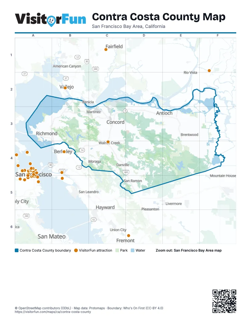
Street index of Contra Costa County
Each street on the sheet and the grid squares it crosses.
- Carquinez BridgeB2
- Eastshore FreewayB2, A3, B3, B4
- Linus F. Claeys FreewayB2, B3
- Benicia-Martinez BridgeC2, C3
- John T. Knox FreewayA3, B3, B4
- Richmond-San Rafael BridgeA3
- John Muir ParkwayB3
- Senator Daniel E Boatwright HighwayC3, C4
- CA 4E3
- I-505 / CA 4 / Sacramento Bypass / West Side FreewayE3
- Caldecott TunnelB4
- Donald D Doyle HighwayC4, D4, D5
- Senator Daniel E. Boatwright HighwayC4
- I-680 Southbound RampsD5
Things to do on the Contra Costa County map
Places on the map
- Abba Self & RV Storage
- Acalanes Ridge Open Space
- ACME Landfill
- Al McNabney Marsh
- Alamo
- Alamo Creek
- Almond Ranch
- Amports
- Antioch
- Antioch Municipal Reservoir
- Auto Warehousing Co.
- BART Concord Yard
- Bart Linear Park
- BART Richmond Yard
- Bay Point
- Bayview-Montalvin
- Belleterre
- Bent Creek
- Berkeley Country Club
- Bethel Island
- Bethel Island Golf Course
- Bettencourt Ranch
- Big Break Regional Shoreline
- Bishop Estates
- Bishop Ranch 2600
- Bishop Ranch Business Park
- Black Diamond Mines Regional Preserve
- Blackhawk
- Bloomfield Vineyards
- Brentwood
- Brentwood Park
- Bridle Gate
- Briones Regional Park
- Briones Reservoir
- Brown Ranch Mitigation Lands
- Byron
- Byron Vernal Pools
- Cameo Acres
- Camino Tassajara
- Canyon Crest
Next to Contra Costa County
- American Canyon
- Benicia
- Berkeley
- Daly City
- Fairfield
- Fremont
- Hayward
- Livermore
- Mountain House
- Oakland map
- Pleasanton
- Rio Vista
- San Francisco map
- San Leandro
- San Mateo
- Tiburon
- Union City
- Vallejo
© OpenStreetMap contributors (ODbL) · Map data: Protomaps · Boundary: Who's On First (CC-BY 4.0)