

California map
Hawthorne map
About 83,633 people live here (Census Bureau, 2024 estimate). The sheet's index lists 208 streets; San Diego Freeway, Century Freeway and West El Segundo Boulevard cross the most grid squares. Also on it: Abandoned Hawthorne Plaza, College Medical Center Hawthorne Campus and Former "The Broadyway".
Open the map (PDF, US Letter)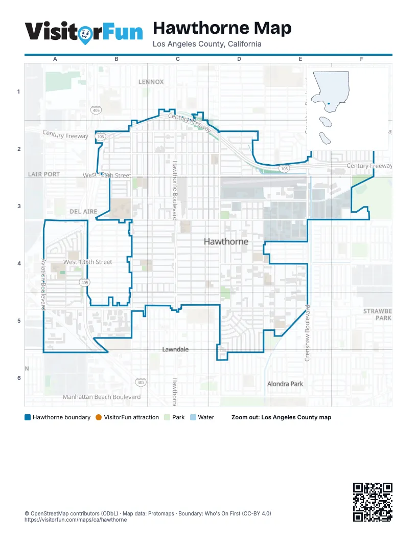
Street index of Hawthorne
Each street on the sheet and the grid squares it crosses.
- 111th StreetC1
- Century FreewayC1, B2, C2, D2, E2, F2
- Hawthorne BoulevardC1, C2, C3, C4, C5
- Mansel AvenueC1, C2
- South Burin AvenueC1, C2
- South Eastwood AvenueC1
- South Freeman AvenueC1
- South Grevillea AvenueC1, C2
- West 111th StreetC1
- 116th StreetB2, C2, D2
- Condon AvenueB2, B5
- Dalerose AvenueB2
- Eucalyptus AvenueB2, B3, B4, B5
- Felton AvenueB2
- Gale AvenueB2, B3, B4, B5
- Inglewood AvenueB2, B3, B4, B5
- San Diego FreewayB2, A3, B3, A4, A5, B5, B6
- South Inglewood AvenueB2
- Sundale AvenueB2, B3
- Tahoe AvenueB2
- West 115th StreetB2, D2, F2
- West 116th StreetB2, D2, E2, F2
- West 117th StreetB2, C2, D2, E2, F2
- West 118th PlaceB2, D2, E2, F2
- West 118th StreetB2, C2, D2, E2, F2
- West 119th PlaceB2
- West 119th StreetB2, C2, D2
- West 120th StreetB2, C2, D2, E2, F2
- West Imperial HighwayB2, C2, D2
- 115th StreetC2
- Acacia AvenueC2
- Birch AvenueC2, C3
- Cedar AvenueC2, C3
- Freeman AvenueC2, C3
- Grevillea AvenueC2, C3, C4, C5
- Hawthorne Boulevard Frontage RoadC2, C3
- Hawthorne WayC2, C3
- Larch AvenueC2
- Manor DriveC2, C3
- Menlo AvenueC2, C3
- Oxford AvenueC2, D3
- Ramona AvenueC2, C3, C4, C5
- South Firmona AvenueC2
- Truro AvenueC2, C3, B4, B5
- 119th PlaceD2
- Almertens PlaceD2
- Doty AvenueD2, D3, D4, D5, D6
- Kornblum AvenueD2, D3, D4, D5, D6
- Prairie AvenueD2, D3, D4, D5, D6
- South Kornblum AvenueD2
- York AvenueD2, D3
- 119th StreetE2, F2
- Ardath AvenueE2
- Atkinson AvenueE2
- Casimir AvenueE2, F2
- Chanera AvenueE2
- Crenshaw BoulevardE2, E3, E4, E5
- Wilkie AvenueE2, E3
- 115th PlaceF2
- Acadia CourtF2, F3
- Central Park CircleF2, F3
- Cimarron AvenueF2, F3
- Daleside AvenueF2
- Daphne AvenueF2, F3
- Fairmont CourtF2, F3
- Haas AvenueF2
- Jackson Square CourtF2, F3
- Loganside DriveF2
- Millennium Park CourtF2, F3
- Purche AvenueF2
- Rock Creek CourtF2, F3
- South Van Ness AvenueF2, F3
- South Wilton PlaceF2
- Spinning AvenueF2
- Tarron AvenueF2
- Central AvenueA3, A4
- City DriveA3
- East El Segundo BoulevardA3
- Glasgow PlaceA3, A4, A5
- Hindry AvenueA3, A4, A5
- Manhattan CourtA3
- Mission AvenueA3
- OceanA3
- Pacific TrailA3
- Park PlaceA3, A4
- StrandA3
- Three Sixty LaneA3
- Union AvenueA3, A4
- West El Segundo BoulevardA3, B3, C3, D3, E3, F3
- Wiseburn StreetA3, A4
- 123rd PlaceB3
- BroadwayB3, C3, D3
- Burl AvenueB3
- Ocean Gate AvenueB3, B5
- West 121st StreetB3
- West 122nd StreetB3
- West 123rd StreetB3
- West 124th StreetB3
- West 129th StreetB3, C3, D3
- West 130th StreetB3, C3, D3
- 122nd StreetC3, D3
- Jefferson AvenueC3, C4, C5
- Michu LaneC3
- Washington AvenueC3, C4, C5
- West 126th StreetC3, D3, F3
- Cordary AvenueD3, D4, D5, D6
- Cranbrook AvenueD3, D5, D6
- Florwood AvenueD3, D4, D5, D6
- Fonthill AvenueD3, D5, D6
- Jack Northrop AvenueD3, E3
- Roselle AvenueD3, D4
- SpaceX Starlink EntranceD3
- Yukon AvenueD3, D4, D5
- Cerise AvenueE3, E4, E5
- Chadron AvenueE3, E4, E5
- Common Space Brewery DrivewayE3
- Innovative WayE3
- Rocket RoadE3
- Simms AvenueE3, E4
- Weber WayE3
- Cypress Knoll LaneF3
- Denali CourtF3
- Glen Eagles DriveF3
- Golden Gate CourtF3
- Griffith CourtF3
- Pine Valley DriveF3
- Pinehurst LaneF3
- Saint Andrews WayF3
- Saint Augusta LaneF3
- Stanley Park CourtF3
- Tivoli Park CourtF3
- 132nd StreetA4
- 134th StreetA4
- 136th StreetA4
- 137th PlaceA4, B4, C4
- 137th StreetA4
- 138th PlaceA4
- 139th StreetA4, E4
- Alaska AvenueA4
- Aviation BoulevardA4, A5, A6
- BoardwalkA4
- Delafield AvenueA4
- Grider AvenueA4
- Hansworth AvenueA4
- Heather WayA4
- Isis AvenueA4, A5
- Judah AvenueA4, A5
- Palm DriveA4
- Rossburn AvenueA4
- South Clydepark AvenueA4
- West 134th PlaceA4, B4, D4
- West 134th StreetA4, B4, C4, D4
- West 135th StreetA4, B4, C4, D4, E4
- West 138th StreetA4, B4, C4, D4
- West 131st StreetB4, C4, E4
- West 132nd StreetB4, C4, D4
- West 133rd StreetB4, C4, D4
- West 136th StreetB4, C4, D4
- West 137th StreetB4, C4, D4
- South Hawthorne WayC4, C5
- South Manor DriveC4, C5
- West 139th StreetC4, D4, E4
- Lisso AvenueD4
- Lisso StreetD4
- West 132nd PlaceD4
- Galli StreetE4
- Lemoli AvenueE4, E5
- Slayton StreetE4
- 140th StreetA5
- 141st StreetA5, B5, C5
- 142nd PlaceA5
- 142nd StreetA5
- 33rd StreetA5
- Konami WayA5
- Rosecrans AvenueA5
- West 142nd PlaceA5
- West 145th StreetA5, B5, D5
- West 149th PlaceA5
- West Rosecrans AvenueA5, B5, C5, D5, E5
- Court WayB5
- South Ocean Gate AvenueB5
- South Shoup AvenueB5
- West 140th StreetB5, C5
- West 141st StreetB5, C5, D5
- West 142nd StreetB5, C5, D5
- West 147th StreetB5, D5, E5
- 144th PlaceD5
- 144th StreetD5
- 145th StreetD5
- 148th PlaceD5
- Bodger AvenueD5, D6
- Gerkin AvenueD5
- Prarie AvenueD5
- Ruthbar DriveD5
- West 144th PlaceD5
- West 144th StreetD5
- West 146th StreetD5
- West 147th PlaceD5
- West 148th StreetD5
- West 149th StreetD5
- Arbor LaneE5
- Cottage LaneE5
- Garden LaneE5
- Lemoli WayE5
- Park LaneE5
- Marine AvenueA6, B6, D6
- Mettler DriveA6
- Redondo Beach AvenueB6
Places on the map
- Abandoned Hawthorne Plaza
- All Star Wholesale Electric Supply
- Andres Auto Body & Paint
- Arco
- Ashley HomeStore
- Aviation Elementary School
- Ayres Hotel
- Best Buy
- Burlington
- Candlewood Suites Lax Hawthorne
- Chips Restaurant
- Church of the Nazarene
- Cimarron Elementary School
- College Medical Center Hawthorne Campus
- Comfort Inn Cockatoo Near LAX Airport
- Common Space Brewery
- Costco
- Crenshaw Park And Ride
- CVS Pharmacy
- DaVita Hawthorne Dialysis
- FedEx Ship Center
- Former "JCPenney"
- Former "Montgomery Ward"
- Former "The Broadyway"
- Hawthorne Branch County of Los Angeles Public Library
- Hawthorne City Hall
- Hawthorne Gateway Shopping Center
- Hawthorne High School
- Hawthorne Municipal Airport
- Hawthorne Park and Ride
- Hawthorne Police Department
- Hobby Lobby
- Holly Park
- LA Fitness
- LAX Stadium Inn
- McDonald's
- Ramada Hawthorne/LA Stadium
- Subaru Pacific
- U.S. Bank
- Wiseburn Branch County of Los Angeles Public Library
Next to Hawthorne
- Alondra Park
- Del Aire
- Lair Port
- Lawndale map
- Lennox
- Strawberry Park
© OpenStreetMap contributors, Open Database License, openstreetmap.org/copyright · Map data: Protomaps · Boundary: Who's On First (CC-BY 4.0); Quattroshapes (CC BY 2.0)















