

California map
Inyo County map
About 18,485 people live here (Census Bureau, 2024 estimate). The sheet's index lists 300 streets; Grand Army of the Republic Highway, North Main Street and Death Valley Scenic Byway cross the most grid squares. Things to do inside the boundary: Badwater Basin, Death Valley National Park and Mount Whitney.
Open the map (PDF, US Letter)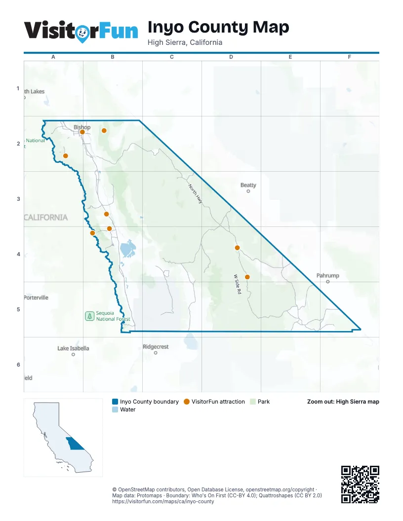
Street index of Inyo County
Each street on the sheet and the grid squares it crosses.
- Grand Army of the Republic HighwayA2, B2, B3, B4, B5
- Death Valley Scenic BywayD3, C4, D4
- Death Valley RoadD3, E4, E5
- North HighwayC3, D3
- Trona–Wildrose RoadC4, C5
- Charles Brown HighwayE5
- Route 395A2
- Panamint Valley RoadC4, C5
- El Camino SierraA2, B2
- Mud Canyon RoadD3
- Daylight Pass RoadD3
- South Main StreetA2, B4, C4
- North Sierra HighwayA2
- North Main StreetA2, B2, B4, C4
- South Edwards StreetB3
- North Edwards StreetB3
- Blue Star Memorial HighwayB5
- Trona RoadC5
- Highway 190D4, E4
- Nine Mile Canyon RoadB5
- Scotty's Castle RoadC3
- Old U.S. Route 395B4
- Ash Meadows RoadE4, E5
- West Line StreetA2
- North Barlow LaneA2
- Wye RoadA2, B2
- State Line RoadE4
- Crystal Geyser RoadB4
- Death Valley - Big Pine RoadB2, C2, C3
- Badwater RoadD4, D5
- China Lake Ranges RoadC4, C5
- Jubilee Pass RoadD5, E5
- Old Spanish Trail HighwayE5, F5
- Emigrant Canyon RoadC4, D4
- Horseshoe Meadows RoadB4
- Mesquite Valley RoadE5, F5
- Mazourka Canyon RoadB3
- Tinemaha RoadB2, B3
- Onion Valley RoadB3
- Whitney Portal RoadB4
- Ophir RoadC4
- Pine Creek RoadA2
- Beatty Cutoff RoadD3, D4
- Furnace Creek Wash RoadE5
- County RoadB2
- Furnace Creek RoadE5
- South Lake RoadA2
- Ubehebe Crater RoadC3
- Olancha Darwin RoadC4
- North Round Valley RoadA2
- South Round Valley RoadA2
- Poleta RoadA2, B2
- Collins RoadA2, B2
- Tecopa Hot Springs RoadE5
- Sunland DriveA2
- Gerkin RoadA2
- Old Sherwin Grade RoadA2
- Lubken Canyon RoadB4
- West Old Spanish Trail HighwayF5
- Brockman LaneA2
- Ed Powers RoadA2
- East Old Spanish Trail HighwayF5
- Rock Creek RoadA2
- Aberdeen Station RoadB3
- Dixon LaneA2
- Sawmill RoadA2
- Excelsior Mine RoadE5, F5
- Schober LaneA2
- South Barlow LaneA2
- Red Hill RoadA2
- Starlite DriveA2
- Mill Creek RoadA2
- Smith Talc RoadE5
- Reynolds RoadB2
- Diaz LaneA2
- North See Vee LaneA2
- Sierra StreetA2, B4
- Home StreetA2, B2
- Saniger LaneA2
- Lake Sabrina RoadA2
- Hanby AvenueA2
- East Market StreetB3, C4
- Sunland Res RoadA2
- East Line StreetA2
- East Yaney StreetA2
- West Market StreetB3, C4
- Spruce StreetA2
- Lake StreetB4
- Southeast Second AvenueC4
- Lower Rock Creek RoadA2
- Tecopa RoadF5
- Mill CreekA2
- Saline Valley RoadB3, C3, C4
- West Side RoadD4, D5
- Racetrack Valley RoadC3
- Greenwater Valley RoadD4, E4, E5
- Waucoba Saline RoadB2, B3
- White Mountain RoadB2
- Los Angeles Aqueduct RoadB3, B4
- Wingate RoadC5, D5
- Owenyo Lone Pine RoadB3, B4
- Dantes View RoadD4
- Cerro Gordo RoadB4, C4
- Eureka Valley RoadB2, C2
- Aqueduct service roadB5
- Darwin RoadC5
- Gill Station Coso RoadB5, C5
- Indian Ranch RoadC5, D5
- South Eureka Valley RoadC2
- Butte Valley RoadD5
- Nadeau RoadC5
- Harry Wade RoadD5, E5
- Cactus Flats RoadB4, B5
- Glacier Lodge RoadA2, B2
- White Mountain Talc RoadB4, C4
- Cinder RoadB5
- Artists Drive Scenic LoopD4
- North Eureka Valley RoadC2
- Buttermilk RoadA2
- Silver Canyon RoadB2
- Charcoal Kilns RoadD4
- East Lubken Canyon RoadB4
- Hogback RoadB3, B4
- Aguereberry Point RoadD4
- Willow Creek RoadC2
- Quarry RoadC5
- Movie RoadB3, B4
- Morgan Mine RoadA2
- G2 Tower RoadC5
- Manzanar Reward RoadB3
- Tuttle Creek RoadB4
- Warm Springs RoadA2, B2
- Pleasant Valley Dam RoadA2
- Sage Flat RoadB4
- Brown RoadC5
- Old State HighwayB4, E5
- Homewood Canyon RoadC5
- RCSC4, C5
- Minnietta-Wildrose Connector RoadC4
- Jean Blanc RoadA2, B2
- Dolomite LoopB4
- Casa Diablo RoadA2
- East Bearona RoadF5
- North Oak Creek RoadB3
- Taboose Creek RoadB3
- Leighton LaneB2
- Moffat Ranch RoadB3
- Cottonwood RoadB4
- Airport RoadB2, D4
- Surprise Canyon RoadC5, D5
- Coyote Valley RoadA2
- Ballarat RoadC5
- Minietta RoadC4
- Canyon RoadB2
- Centerline RoadC5
- Lone Pine Narrow Gauge RoadB3, B4
- Avenue DF5
- Gorge RoadA2
- Fish Slough RoadA2
- Fish Springs RoadB2
- Sterling RoadB5
- West Charity LaneF5
- West Faith LaneF5
- West Charleston LaneF5
- West Hall LaneF5
- West Ley LaneF5
- Bir RoadA2
- Haiwee Canyon RoadB5
- Sulfate RoadB4
- Laws Poleta RoadB2
- Avenue EF5
- Avenue CF5
- Foothill RoadB3
- Talc City RoadC4
- Topaz StreetF5
- Wyman Canyon RoadB2
- Onyx RoadC5
- East Bishop Creek RoadA2
- Black Canyon RoadB2
- Twenty Mule Team Canyon RoadD4
- Titus Canyon RoadD3
- Rogers Peak Service RoadD4
- Fort Independence RoadB3
- Granite View DriveB4
- Tungsten City RoadA2
- Quartz StreetF5
- Goodale RoadB3
- Fall RoadB4
- Avenue BF5
- Silver StreetF5
- Mosaic Canyon RoadD4
- Tower RoadC5
- Rudolph RoadB2
- Eastside RoadB2
- Birchim LaneA2
- China Ranch RoadE5
- Stockwell Mine RoadC5
- Hawk WayF5
- South Purple Sage WayF5
- South Rose WayF5
- Opal StreetF5
- South Deming WayF5
- South Owl WayF5
- North Garnet StreetF5
- East Moon Path LaneF5
- West Shirley LaneF5
- North Lake RoadA2
- East Hall LaneF5
- West Mabel LaneF5
- West Moon Path LaneF5
- East Charleston LaneF5
- East Ley LaneF5
- East Shirley LaneF5
- Olivas Ranch RoadB4
- Mesquite Springs Campground Access RoadC3
- Sunset DriveA2, B4
- Big Trees RoadA2
- Five Bridges RoadA2
- Long RoadF5
- Shop StreetB4
- Ekenberg RoadF5
- Zircon StreetF5
- Fuller RoadB3
- Vanadium Ranch RoadA2
- Bartell RoadB2
- Rosemary LaneF5
- South Oak Creek RoadB3
- Baker Creek RoadB2
- Indian Springs DriveB4
- Natural Bridge RoadD4
- Division Creek RoadB3
- Gus Cashbaugh RoadB2
- Enchanted Lake RoadB4, B5
- South Quail WayF5
- East Faith LaneF5
- Gus Cashbaugh LaneA2, B2
- East Charity LaneF5
- Lake Village RoadB4, B5
- Redding Canyon RoadB2
- Horton Creek RoadA2
- Sub Station RoadB4
- Walker Creek RoadB4
- Gold StreetF5
- Pearson RoadB5
- Riverside RoadA2
- Mustard Canyon RoadD4
- Shabbell LaneB3
- Old Ghost RoadD4
- Joe Smith RoadB2
- Texas Springs RoadD4
- Devils Golf Course RoadD4
- Bearona RoadF5
- Fish Hatchery RoadB3
- Manzanar RoadB3
- Underwood LaneA2
- Haiwee Reservoir RoadB5
- Utah DriveC4
- Sunland Indian Reservation RoadA2
- Pangborne LaneB4
- Talc City CutoffC4
- North Coloseum RoadB3
- Sykes RoadB5
- South Falcon WayF5
- Ironwood WayF5
- South Carpenter WayF5
- North Pa-Ha LaneA2
- North Tu-Su LaneA2
- East Roserwin LaneF5
- North Winuba LaneA2
- Rose WayF5
- Shirley RoadF5
- East Qaqui AvenueF5
- Klondike Lake RoadB2
- West Avenue EF5
- Ruby LaneF5
- West Diamond LaneF5
- East Mabel LaneF5
- East Nama LaneF5
- East Saith LaneF5
- Richards StreetB2
- Piper StreetB2
- North Haiwee RoadB4
- Crater StreetB2
- Mesquite Springs CampgroundC3
- Thundercloud LaneB4
- Dump RoadB3
- Oasis RoadB2
- Keough Hot Springs RoadB2
- Noonday StreetE5
- North Willow LaneB3
- Rocking K RoadA2
- Birch Creek RoadB2
- Reata RoadA2
- Skyline DriveD4
- Black Rock Springs RoadB3
- Stampmill RoadE5
- Trona Airport RoadC5
- Clay RoadE4
- Avenue AF5
- Quartz AvenueF5
Things to do on the Inyo County map
Places on the map
- Airport Lake
- Alabama Hills National Scenic Area
- Amargosa Canyon
- Ancient Bristlecone Pine Forest
- Argus Range Wilderness
- Ash Meadow
- Badwater Basin
- Big Pine / Tovowahamatü
- Bishop
- Bishop Golf Club
- Boraxo Mine
- Briggs Mine
- Bureau of Land Management
- California Valley
- Cartago
- Cartago Wildlife Area
- Cashbaugh Ranch Lease
- Charleston View
- Chicago Valley
- Coso Range Wilderness
- Darwin Falls Wilderness
- Death Valley National Park
- Death Valley Wilderness
- Fish Slough Ecological Reserve
- Funeral Mountains Wilderness
- Great Falls Basin Wilderness
- Ibex Wilderness
- Inyo Mountains Wilderness
- Malpais Mesa Wilderness
- Manly Peak Wilderness
- Nopah Range Wilderness
- Pahrump Valley Wilderness
- Piper Mountain Wilderness
- Resting Spring Range Wilderness
- Sacatar Trail Wilderness
- South Nopah Range Wilderness
- Surprise Canyon Wilderness
- Sylvania Mountains Wilderness
- Trona Airport
- Whitney Zone
Next to Inyo County
- Beatty
- Lake Isabella
- Pahrump
- Ridgecrest map
© OpenStreetMap contributors, Open Database License, openstreetmap.org/copyright · Map data: Protomaps · Boundary: Who's On First (CC-BY 4.0); Quattroshapes (CC BY 2.0)















