

California map
Menlo Park map
About 33,040 people live here (Census Bureau, 2024 estimate). The sheet's index lists 300 streets; Willow Road, Santa Cruz Avenue and Bayfront Expressway cross the most grid squares. Also on it: Bedwell Bayfront Park, Meta West Campus and Pond SF2.
Open the map (PDF, US Letter)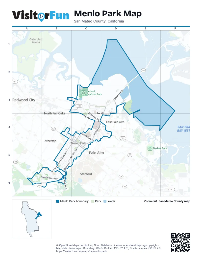
Street index of Menlo Park
Each street on the sheet and the grid squares it crosses.
- Bayfront ExpresswayD2, C3, D3
- Bayshore FreewayC3, C4, D4
- Dumbarton BridgeD2, E2
- Junipero Serra FreewayA6, B6
- Willow RoadD3, C4, D4, C5
- Sand Hill RoadA6, B6
- El Camino RealB4, C4, C5
- Santa Cruz AvenueC4, B5, C5, B6
- University AvenueD3
- Marsh RoadB3, C3
- Junipero Serra BoulevardB6
- Middlefield RoadC4
- Ravenswood AvenueC4, C5
- Alpine RoadB6
- Chester StreetC4, D4
- Alameda de las PulgasB6
- Sharon Park DriveA6, B6
- Bay RoadC3, E3, C4
- Laurel StreetB4, C4, C5
- Middle AvenueB5, C5
- Oak Grove AvenueC4, B5
- Alma StreetC4, C5
- Oak AvenueC4, B5, B6
- O'Brien DriveD3, D4
- Haven AvenueB3, C3
- Encinal AvenueB4
- Bohannon DriveB3, C3
- Avy AvenueB5, B6
- Ringwood AvenueC4
- Scott DriveC3
- Valparaiso AvenueB4, B5, B6
- Glenwood AvenueB4
- Watkins AvenueB4
- Vine StreetB6
- South Sharon Park DriveB6
- Florence StreetB3
- Ivy DriveC3, D3, C4
- Chilco StreetC3, C4
- Woodland AvenueC4, D4
- Trinity DriveA6, B6
- San Mateo DriveB5, C5
- Hamilton AvenueC3, D3
- University DriveB5, C5
- Arbor RoadB5, C5
- Monte Rosa DriveB6
- Hacker WayD3
- Bay Laurel DriveB5, C5
- Cotton StreetB5, C5
- Laurel AvenueC4, D4
- Van Buren RoadC3, C4
- Pierce RoadC3, C4
- Constitution DriveC3
- Hermosa WayB5, C5
- Linfield DriveC4, C5
- Hedge RoadC3
- Seminary DriveC4
- Madera AvenueC3, D3, C4
- Sevier AvenueC3, D3, C4
- Carlton AvenueD3, C4, D4
- Windermere AvenueC3, C4
- Hollyburne AvenueC3, C4
- Branner DriveB6
- Gilbert AvenueC4, D4
- Meta WayC3, D3
- Stanford AvenueB5, B6
- Oakdell DriveB5
- Sharon RoadB5, B6
- Hobart StreetB5
- Olive StreetB5, C5
- Sand Hill CircleA6
- Henderson AvenueC3, C4
- Newbridge StreetC4
- Lassen DriveB6
- Waverley StreetC4, C5
- Bedwell Bayfront ParkC3
- Siskiyou DriveA6, B6
- Menalto AvenueD4
- Menlo Oaks DriveC4
- Felton DriveB4
- Creek DriveC5
- Almanor AvenueC3, C4
- College AvenueC5
- Cambridge AvenueC5
- Central AvenueD4
- East Creek DriveC5
- Santa Monica AvenueC4
- Pope StreetC4, D4
- Coleman AvenueC4
- Menlo AvenueB5, C5
- Lemon StreetB5
- Continental DriveB6
- Crane StreetB5, C5
- Santa Margarita AvenueC4
- Garwood WayB4, C4
- Roble AvenueC5
- O'Connor StreetD4
- Hospital PlazaC4
- Berkeley AvenueC4
- Jefferson DriveC3
- Oak CourtD4
- Fremont StreetB5, C5
- Windsor DriveB5, C5
- Adams DriveD3
- Concord DriveC4
- Tioga DriveA6, B6
- Yale RoadC5
- Sharon Oaks DriveB6
- Burgess DriveC4, C5
- Durham StreetC4, D4
- Live Oak AvenueC5
- Warehouse RoadC4
- 4th StreetC4
- Del Norte AvenueC3, C4
- O'Keefe StreetC4, D4
- Marmona DriveC4
- Terminal AvenueC3
- Gloria CircleC4
- East O'Keefe StreetD4
- Sherwood WayC5
- Hillview DriveB5
- Partridge AvenueC5
- Claremont WayC5
- Independence DriveC3
- Altschul AvenueB6
- McKendry DriveC4
- Politzer DriveB5
- Oak Knoll LaneB5, B6
- Harvard AvenueC5
- North Lemon AvenueB5
- South Perimeter RoadC4
- Elder AvenueB5
- Johnson StreetB5
- Redwood AvenueC4
- Wallea DriveB5
- Klamath DriveB6
- Chrysler DriveC3
- Elm StreetC4, D4
- Market PlaceC3, C4
- Princeton RoadC5
- Eastridge AvenueB6
- Campbell LaneB6
- Campbell AvenueC3
- Lorelei LaneB3, C3
- West 3rd StreetC4
- Lexington DriveC4
- Ralmar AvenueD4
- Recreation AvenueC4
- Euclid AvenueD4
- Stone Pine LaneB4
- Cascade DriveB6
- Oakhurst PlaceC3
- Deanna DriveB6
- Lennox AvenueB4
- Arden RoadB4
- Haight StreetD4
- Sonoma AvenueC4
- Hallmark CircleB5, B6
- Alto LaneC5
- Arnold WayC4
- West Perimeter RoadC4
- White Oak DriveB5, B6
- Oakland AvenueC4
- Hesketh DriveB5
- San Antonio StreetB4
- Crest LaneB6
- Hoover StreetB4, B5
- Doris DriveB5
- Hanna WayC4
- Paulson CircleC4, C5
- Greenwood DriveC3, C4
- Mills StreetB4, C4
- Warner Range AvenueB6
- Marcussen DriveC4
- Pine StreetC4
- Noel DriveC4
- Robin WayC4
- Walnut StreetC4, D4
- Anderson WayB6
- la Loma DriveB6
- Survey LaneC4
- Modoc AvenueC3
- Alma LaneC4
- Hill AvenueC3
- Merrill StreetC4, C5
- Commonwealth DriveC3
- Peggy LaneC3
- Sandlewood StreetC3
- Chestnut StreetB5, C5
- Shasta LaneA6, B6
- Nash AvenueC4
- Trenton WayC4
- Blackburn AvenueC4
- Spruce AvenueB4
- Maywood LaneC5
- Loma Prieta LaneB6
- Sierra DriveB6
- Holly AvenueB5
- Poppy AvenueB5
- Oak Hollow WayB6
- Clayton DriveB6
- Olympic AvenueB6
- A StreetC4
- Buckthorn WayB4
- Evergreen StreetB5
- Florence LaneC5
- Magnolia StreetB5
- Iris LaneC3, C4
- Ambar WayB5, C5
- East 2nd StreetC4
- Dunsmuir WayC3
- Tehama AvenueC4
- Evelyn StreetB5, C5
- Rural LaneB6
- Morgan LaneC4
- Whitney DriveB6
- Corinne LaneB5
- Biltmore LaneB6
- Hamilton CourtD3
- Oakwood PlaceC4
- Elliott DriveD4
- Kenwood DriveC5
- Delfino WayB5
- Garden LaneB5
- Sunset LaneB6
- Sherman AvenueB5
- Theresa CourtC3
- Blueridge AvenueB6
- Santa Rita AvenueB5, C5
- Campo Bello LaneB6
- Curtis StreetC5
- Timothy LaneC3
- Edgewood LaneB5
- Cornell RoadC5
- Grayson CourtC4, D4
- Rosefield WayB5
- Claire PlaceC5
- Barton WayC4
- Callie LaneC3
- Adams CourtD3
- Riordan PlaceC4
- Plumas AvenueC3
- Westfield DriveC5
- May Brown AvenueB5
- Blake StreetC5
- Garland DriveB5
- Sharon Park RoadB6
- Robert S DriveB5
- Homewood PlaceC4
- Werth AvenueB5
- Chestnut LaneB5, C5
- Palm CourtB5
- East 1st StreetC4
- Elizabeth LaneB4, B5
- Mansion CourtB6
- D StreetC4
- Millie AvenueB5
- Rose AvenueB5
- Hopkins StreetC4, C5
- Baywood AvenueC4
- Bieber AvenueC3
- Harmon DriveC3
- Artisan WayC5
- Oliver CourtB5
- Grace DriveB5
- Alice LaneC5
- Maloney LaneC4, C5
- Morey DriveC5
- Pineview LaneB5
- B StreetC4
- Oak LaneB5, C5
- West 1st StreetC4
- Susan Gale CourtB6
- Regal CourtC4, D4
- Louise StreetB5
- Greenwood PlaceC3
- Henderson PlaceC3
- Clover LaneC4
- Atkinson LaneB5
- Saga WayB6
- Coleman PlaceC4
- Saint Francis PlaceB5
- Shoppe LaneC4
- WBRC DriveC4
- Barron StreetC4, C5
- Orange AvenueB5
- Byers DriveD4
- Croner AvenueB5
- Wood LaneB5
- Christopher WayC3
- Fanita WayB5
- Howard StreetC4
- Laurel PlaceB4
- Oakfield LaneB5
- Doyle StreetC5
- August CircleB5
- Harkins AvenueB6
- Lee DriveB5
- Haven CourtC3
- Johnston LaneC5
- Nova LaneC4
Places on the map
- 1 Hacker Way
- A-A Lock
- Allied Arts
- Allied Arts Guild
- Arillaga Family Gym
- Arrillaga Family Gymnastics Center
- Arrillaga Family Recreation Center
- Bedwell Bayfront Park
- Belle Haven Elementary School
- Building 20 Rooftop Park
- Burgess Park
- Chorpus Christi Monastery
- Downtown Menlo Park
- Flood County Park
- Hillview Middle School
- Holy Cross Cemetery
- Kelly Park
- La Entrada Middle School
- McKeon Memorial Library
- Menlo Park City Hall
- Menlo Park Surgical Hospital
- Meta West Campus
- Nealon Park
- Oak Knoll Elementary School
- Philips Brooks Private School
- Pond SF2
- Ravenswood Open Space Preserve
- Salt Evaporators
- Sand Hill
- Sequoia Belle Haven
- Sharon Heights Golf Course
- Sharon Hills Park
- Sharon Park
- SRI International
- The UPS Store
- US Geological Survey Menlo Park Campus
- USGS Library
- VA Medical Center Menlo Park
- Vallombrosa Center
Next to Menlo Park
- Atherton
- East Palo Alto map
- North Fair Oaks
- Palo Alto map
- Redwood City map
- Stanford
© OpenStreetMap contributors, Open Database License, openstreetmap.org/copyright · Map data: Protomaps · Boundary: Who's On First (CC-BY 4.0); Quattroshapes (CC BY 2.0)















