

California map
Redwood City map
About 82,982 people live here (Census Bureau, 2024 estimate). The sheet's index lists 300 streets; Bayshore Freeway, Woodside Road and Jefferson Avenue cross the most grid squares. Also on it: Bair Island Ecological Reserve, Belmont Slough and Cordilleras Creek.
Open the map (PDF, US Letter)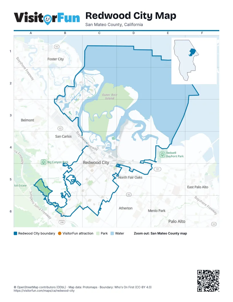
Street index of Redwood City
Each street on the sheet and the grid squares it crosses.
- Bayshore FreewayC3, C4, D4, E4
- Woodside RoadD4, D5, C6, D6
- El Camino RealC4, D5
- Veterans BoulevardC4, D4
- Main StreetC4, D4, D5
- Redwood AvenueC5, D5
- Marsh RoadE4, E5
- Pine StreetD4, D5
- Laurel StreetD4, D5
- Hazel AvenueD5
- Seaport BoulevardD3, E3, D4
- Redwood Shores ParkwayC1, B2, C2
- Jefferson AvenueC4, B5, C5, B6
- Marine ParkwayC1, B2, C2
- Alameda de las PulgasB4, C4, C5, C6
- Twin Dolphin DriveB2, C2
- Whipple AvenueB4, C4, B5
- Farm Hill BoulevardC5, B6, C6
- Brewster AvenueC4, B5, C5
- Edgewood RoadB4, C4, A5
- Middlefield RoadC4, D4, D5
- Shearwater ParkwayC1
- Industrial WayC4
- Holly StreetB2, B3
- Hinman RoadD3
- East Hopkins AvenueC5
- Industrial RoadC4
- BroadwayC4, D4, E4
- Bridge ParkwayB1, C1, B2, C2
- Roosevelt AvenueC5, D5, C6
- East Bayshore RoadC4, D4, E4
- Hudson StreetC4, C5, D5
- Hopkins AvenueC4, B5, C5
- Chestnut StreetD4, D5
- Maple StreetC4, D4
- Shell ParkwayC1, C2
- Valota RoadC5, C6
- Shoreline DriveB2
- Bay RoadD4, E4, E5
- Oracle ParkwayB2
- Winslow StreetC4
- Marshall StreetC4, D4
- Spring StreetD4, E5
- Davit LaneC1, C2
- Charter StreetD4, D5
- Douglas AvenueD4, D5
- Haven AvenueE4
- Duane StreetC4
- The EmbarcaderoC1
- Stafford StreetC4
- Canvasback WayC1
- Hastings Shore LaneB2, C2
- Cormorant DriveB2
- Shoreway RoadB2, B3
- Lathrop StreetC4, D4, D5
- Florence StreetE5
- Pico BoulevardC2, B3, C3
- Skyway RoadC2, B3
- Old County RoadC4
- Scott DriveE4
- Saint Lucia DriveC1
- Nimitz AvenueC6
- James AvenueC4, C5
- Madison AvenueC4, C5
- Oak AvenueC5, D5
- Vera AvenueC4, C5
- Clinton StreetC4, C5, D5
- King StreetC4, C5
- Grand StreetC4, C5
- Iris StreetC4, C5
- Kentfield AvenueD4, C5, D5
- Virginia AvenueC5, C6
- Myrtle StreetC4, C5
- Rolison RoadE4
- Hoover StreetE4
- Page StreetD4, E4
- Fernside StreetC5, C6
- Fulton StreetC4, C5
- Connecticut DriveC5, C6
- Harrison AvenueC4, C5
- Goodwin AvenueC5, C6
- Palm AvenueC5, C6
- Upland RoadB5, C5
- Radio RoadC1
- Avocet DriveC2
- Ruby StreetC5
- Saint Francis StreetC5
- Arlington RoadC4
- Jeter StreetC4, C5
- Hampton AvenueC5, C6
- Arguello StreetC4
- Massachusetts AvenueC6
- Corriente Point DriveC1
- McGarvey AvenueC5
- Newport CircleC1, B2, C2
- Walnut StreetD4
- Topaz StreetC5
- Poplar AvenueC5, D5
- Maddux DriveC6
- Woodhill DriveB6
- Stambaugh StreetC4, D4
- Roble AvenueE4, D5
- Carson StreetC5, C6
- 5th AvenueE4
- Canyon RoadB5, C5
- Maryland StreetC6
- Sierra StreetC5
- Carolina AvenueC6
- Hillview AvenueC4, C5
- Adams StreetC4, D5
- Cleveland StreetC4, C5
- Herkner RoadD3
- Gordon StreetC5, D5
- Nevada StreetC4, C5
- Beech StreetC4, D4
- Lowell StreetC4, C5
- Washington AvenueC5, C6
- Katherine AvenueC4, C5
- Elwood StreetC4
- Chesterton AvenueC5
- Kentucky StreetC5, C6
- Upton StreetC5
- Highland AvenueB5, C5
- Country Club DriveB6, C6
- Cork Harbour CircleB2
- Quartz StreetC5
- Altamont WayB5, C5
- Carlos AvenueD5
- Westpoint Harbor DriveE3
- Lincoln AvenueC4, C5
- Anamor StreetC6
- Crompton RoadC5, C6
- Blandford BoulevardB4, C4
- Warren StreetC4
- Bret Harte DriveB6
- Ebener StreetC5, D5
- Waterside CircleC2
- Chesapeake DriveD3
- Harding AvenueB5, C5
- Rockport AvenueC1
- Emerald Hill RoadB6
- Bennett RoadB5
- Junipero AvenueC5
- Sapphire StreetC5
- Blomquist StreetD4
- Eden Bower LaneB6
- Atherwood AvenueC5, D5, D6
- Silver Hill RoadB6
- Allerton StreetC4
- Oak Knoll DriveB5
- Shannon WayC2
- Shorebird CircleB2
- Glennan DriveB5, B6, C6
- 15th AvenueE4, E5
- Oxford StreetC5, D5
- Bair Island RoadD3, C4, D4
- Lakeshore DriveC1, C2
- 3rd AvenueD4, E4
- Arch StreetC4
- Cedar StreetD4, D5
- Lenolt StreetC4
- Orchard AvenueD5
- 2nd AvenueD4, E4
- Ohio AvenueC6
- Scott AvenueD4, D5
- Regent StreetC5, D5
- Hillcrest DriveB5, C5
- Lagoon DriveB2
- Marlin CourtC2
- Center StreetD5
- Pennsylvania AvenueC4, D4
- Hilton StreetD4
- Martinique DriveC2
- Marlin DriveC2
- Monaco DriveC1
- 17th AvenueE4, E5
- Johnson StreetC5
- Jackson AvenueC4, C5
- Whisperwave CircleC1
- Birch StreetC4
- Heller StreetD4
- Willow StreetD4, D5
- Mediterranean LaneC1, C2
- 10th AvenueE4
- Bowsprit DriveB2
- Flynn AvenueD4, D5
- Genoa DriveC1
- Buckeye StreetD4, D5
- G StreetC4
- Gossamer AvenueC1
- Cypress StreetD5
- California WayB6
- Convention WayC4
- Lanyard DriveB2
- Hastings AvenueC5
- Chelsea WayD5, D6
- Mindanao DriveC1
- Delaware AvenueC6
- Castle Hill RoadB5, B6, C6
- Bradford StreetC4, D4
- Cassia StreetD4
- D StreetC4
- Governors Bay DriveC1
- Cordilleras RoadB5
- Tiller LaneC2
- Glenwood AvenueB5
- Island DriveB2
- B StreetC4
- Spruce StreetD4, D5
- Shasta StreetD4, D5
- 8th AvenueE4
- Meridian DriveC1
- Sequoia WayB4, B5
- Alverno CourtB6
- E StreetC4
- Oakdale StreetC4
- Anchor CircleC2
- Island PlaceB2
- Finger AvenueC4
- Keelson CircleC2
- Union AvenueC5, D5
- Avenue del OraC5
- Windsor WayC5, C6
- Park StreetD5
- Lancaster WayC5
- Cardinal WayD3
- Oak Ridge DriveC5
- Briarfield AvenueC5
- Cambridge RoadB6
- Inner CircleC5
- Manzanita StreetD4, D5
- Seminole WayB5
- C StreetC4
- Oddstad DriveD4
- Positano CircleC1
- Port Walk PlaceB1, C1, B2
- Wheeler AvenueD5
- Central AvenueD5
- Saginaw DriveD3
- Eaton AvenueB4
- Quay LaneB2
- Barnegat LaneC2
- Northumberland AvenueD5
- Truman StreetC5
- Standish StreetC4
- West Oakwood BoulevardD5
- Howland StreetC4
- Seabrook CourtC1
- Westwood StreetC5, C6
- Barkentine LaneC2
- Lakeview WayB5, B6
- Hemlock AvenueD5
- Compass DriveB2, C2
- Baltic CircleC1
- East Oakwood BoulevardD5
- A StreetC4
- Shoal CircleC1
- Alden StreetC4
- Skiff CircleC2
- Teredo DriveC2
- Whitehall LaneD5, D6
- Fairview AvenueC5
- Harcross RoadC6
- Kansas StreetC5, C6
- Samson StreetC4
- Warwick StreetC4
- Oregon AvenueC5, C6
- Foothill StreetC5, C6
- Granger WayC6
- Carleton CourtC5
- Pleasant Hill RoadB6, C6
- Bonita AvenueD5
- Stony Hill RoadB6, C6
- Woodsworth AvenueB4, C4
- Salt CourtC1
- Pelican LaneB2
- Cringle DriveC2
- Galveston DriveD3
- Sanchez WayC5
- Elm StreetD4
- Dockside CircleC2
- Beacon Shores DriveC2
- Horgan AvenueD5
- Hillcrest WayB5
- Kensington RoadC6
- Round Hill RoadB6
- Nueva AvenueD5
- Madrone StreetD5
- Linden StreetD5
- Leahy StreetD5
- Turnsworth AvenueB4, C4
- Brandy Rock WayC6
- Canoe CourtC1
- Franklin StreetC4
- Mohican WayB5
- Price AvenueC4
- Turnbuckle DriveD4
- Jones CourtE4
- Uccelli DriveD3
- Seastorm DriveC1
Places on the map
- Bair Island Ecological Reserve
- Bat Ray Island
- Bay Club Redwood Shores
- Belmont Slough
- Boardwalk Auto Mall
- Boardwalk Place Pond
- Cordilleras Creek
- Costco
- Docktown Marina
- Eagle Hill
- Easter Bowl
- Edgewood Park and Nature Preserve
- Electronic Arts
- Emerald Hills Golf Course
- FedEx
- FedEx Office
- Grand Bay Hotel San Francisco
- Griffin Field and Bechet Field
- Harper Redwood City
- Hoover Park
- Kennedy Middle School
- Mariner Park
- Marlin Park
- Middle Bair Island
- O'Neill Slough
- Oracle Headquarters
- Outer Bair Island
- Pacific Shores Center
- Paragon Point
- Red Morton Community Park
- Redwood Life Office Park
- Redwood Shores Lagoon
- Sequoia High School
- Sequoia Hospital
- Sequoia Station
- Sobrato Center for Nonprofits
- Stanford Redwood City
- Stulsaft Park
- Towers at Shores Center
- Westpoint Harbor
Next to Redwood City
- Atherton
- Belmont map
- Menlo Park map
- North Fair Oaks
- Palo Alto map
- San Carlos map
© OpenStreetMap contributors, Open Database License, openstreetmap.org/copyright · Map data: Protomaps · Boundary: Who's On First (CC-BY 4.0); Quattroshapes (CC BY 2.0)















