

California map
Monterey map
About 29,015 people live here (Census Bureau, 2024 estimate). The sheet's index lists 300 streets; Cabrillo Highway, Monterey Salinas Highway and Del Monte Avenue cross the most grid squares. Things to do inside the boundary: Cannery Row, Monterey Bay Aquarium and Monterey Bay Whale Watch.
Open the map (PDF, US Letter)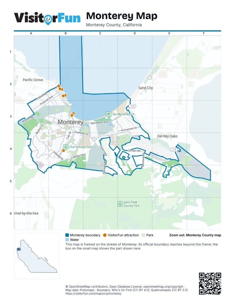
Street index of Monterey
Each street on the sheet and the grid squares it crosses.
- Cabrillo HighwayC3, D3, B4, C4, A5, B5
- Monterey Salinas HighwayC4, D4, E4, E5, F5
- Del Monte AvenueB3, C3, D3
- Lighthouse AvenueB2, B3
- Munras AvenueB3, B4
- Pacific StreetB3, B4
- North Fremont StreetD3
- Aguajito RoadC4, C5
- Soledad DriveA4, B4
- Fremont StreetB3, B4, C4
- Foam StreetB2, B3
- Pacific Grove-Carmel HighwayA3, A4, A5
- Camino AguajitoC3, C4
- Via MiradaB4
- Hannon AvenueD3
- English AvenueD3
- Abrego StreetB3, B4
- Tyler StreetB3
- Del Monte BoulevardD3
- Canyon del Rey BoulevardD2, D3, E4
- Fremont BoulevardD3
- David AvenueA2, B2, A3
- West Franklin StreetA3, B3
- Casa Verde WayC3, D3
- Wave StreetB2
- East Franklin StreetB3
- Washington StreetB3
- Ocean View BoulevardB2
- Skyline DriveA3, B3, A4
- Mar Vista DriveA4, B4
- Garden RoadC4, D4
- Scenic DriveA4, A5
- Prescott AvenueB2, A3
- Iris Canyon RoadB4
- Josselyn Canyon RoadC4, D4
- Hoffman AvenueB2, A3, B3
- El Dorado StreetB4
- Herrmann DriveB3, B4
- Mark Thomas DriveC4
- Pearl StreetB3, C3
- Barnet Segal LaneB4
- Jefferson StreetB3
- Cannery RowB2, B3
- Via del ReyA3, B3
- Via ParaisoB3, B4
- Spencer StreetB2, B3
- Olmsted RoadD4, D5
- Monhollan RoadC5, D5
- Pine StreetA2, B2, B3
- Fairground RoadD3, C4
- Via GayubaA4, B4
- Airport RoadD3, D4
- Madison StreetB3
- Sloat AvenueC3, C4
- Monroe StreetB3
- Alta Mesa RoadB4
- Monte Vista DriveA4, B4
- Camino el EsteroB3
- Filmore StreetA2, A3
- Martin StreetB4
- Johnson StreetB3
- Old Golf Course RoadC4
- High StreetB3
- Alvarado StreetB3
- Skyline Forest DriveA4
- Central AvenueB2
- Irving AvenueA2, B2, A3
- Private Bolio RoadA3, B3
- Casanova AvenueD3, D4
- Mason RoadA3
- Glenwood CircleB4, C4
- Ramona AvenueD3, D4
- Sylvan RoadB4, C4, C5
- Littlefield RoadC5
- Upper Ragsdale DriveF4, F5
- Leahy RoadC4, C5
- Michael J Smith LaneC4, D4
- Dry Creek RoadA3, A4
- Bergin DriveC4
- Laine StreetB2, B3
- Kit Carson RoadA3, B3
- Lower Ragsdale DriveF5
- Hawthorne StreetB2, B3
- Montecito AvenueC3, D3
- Belden StreetB2, B3
- Shubrick RoadC4, C5
- Van Buren StreetB3
- McClellan AvenueB2, A3, B3
- Fishnet RoadB4, C4
- Don Dahvee LaneB4
- Forest Ridge RoadA3, A4
- Archer StreetB2, B3
- Cuesta Vista DriveA4
- Castro RoadC4
- Spruance RoadC4
- Deer Forest DriveD4, D5
- Larkin StreetB3
- Dela Vina AvenueC3, D3
- Viejo RoadB4, B5
- Withers AvenueA2, A3
- Cass StreetB3, B4
- Park AvenueC3, C4
- Montsalas DriveC4
- Fitch AvenueB3
- Farragut RoadC4
- San Bernabe DriveB4
- Alta Mesa CircleB4
- Artillery StreetB3
- Corporal Ewing RoadB3
- Drake AvenueB2, B3
- Roberts AvenueC3, D3
- Cielo Vista DriveA4, B4
- Bear Track RoadA3
- Alameda StreetB4
- Flagghill DriveD5
- West RoadC3, C4
- Ocean AvenueC3, C4
- Harrison StreetA3, B3
- Roosevelt StreetA3, B3
- Oak StreetA2, B3
- Old Salinas HighwayC4
- Toyon DriveA4
- Watson StreetB3
- Cunningham RoadC3
- Colton StreetB4
- Ryan Ranch RoadE4
- Infantry StreetB3
- O'Hare AvenueD4
- Lily StreetA2, A3
- Mesa RoadB3, B4
- Newton StreetA2, B3
- Army StreetB3
- Opossum RoadA3
- Michelson RoadC4, C5
- Hellam StreetB3
- Via IsolaD4, D5
- Webster StreetB3
- Corporal Evans RoadA3, B3
- Cypress StreetA2, A3
- Macarthur RoadA3
- Taylor StreetA3
- Terry StreetA2, A3
- Via del PinarB3, B4
- Encina AvenueC3, D3
- Lawton RoadA3
- Higuera LaneD4
- West Rifle Range RoadA3
- Jessie StreetA3
- Palo Verde AvenueC3, D3
- Parcel StreetA2, A3
- Lobos StreetA3
- Skyline CrestA4
- Lottie StreetA3
- Grace StreetA2, A3
- Alice StreetA3
- Clay StreetB3
- Mervine StreetC5
- Lyndon StreetA2, A3
- Municipal Wharf 2B3
- El Caminito del NorteB3
- Dickman AvenueB2, B3
- Deer Stalker PathD4, D5
- East RoadC3, C4
- Calle PrincipalB3
- Figueroa StreetB3
- Ragsdale DriveE5, F5
- Summit RoadA3
- Revere RoadC5
- University WayC3, C4
- Costanoan DriveC4
- Monterra RoadE4
- 10th StreetC4
- Dunecrest AvenueC3, D3
- Plummer StreetB3
- Virgin AvenueD3
- Wainwright StreetB3
- Euclid AvenueD4
- Ralston DriveD4
- Linda Vista DriveA4
- Grant AvenueD3
- Sierra Vista DriveA4, B4
- 5th StreetC3
- Grace Hopper AvenueD4
- Via LavanderaC4
- Moreell CircleC4
- 6th StreetC3
- Lake DriveC3
- Shepherds Knoll RoadA4
- 1st StreetC3
- 7th StreetC3, C4
- Scenic RoadA3
- Shady LaneA4
- York RoadF5
- 8th StreetC4
- Reeside AvenueB3
- Scott StreetB3
- 4th StreetC3
- Del Robles AvenueC3, D3
- Pinehill WayA3, A4
- 2nd StreetC3
- Edinburgh AvenueD3, D4
- Grove StreetB4
- 3rd StreetC3
- Malloway LaneC4
- Branner AvenueD3
- Garden DriveC3
- Lerwick DriveD3, D4
- Spray AvenueC3
- Leidig CircleC4
- Marsala CircleD4, D5
- Stillwell AvenueB3
- Major Sherman LaneB3, B4
- Via DescansoB4
- Ssg Fronins StreetA3
- Via CastanadaB4
- Ryan CourtF5
- Littleness AvenueD3, D4
- Cortes StreetB3
- Elk RunC4, D4
- San Vito CircleD5
- Cramden DriveA3, A4
- North RoadC3
- Forest Knoll RoadA4
- El Caminito del SurB3
- Dundee DriveD3
- La Mesa WayC4
- Via VenturaB4
- Moran CircleC4
- Trapani CircleD4
- Beach WayC3
- La Playa StreetC3
- Patton AvenueB3
- Eddie Burns LaneB3
- Bruce LaneD3
- Halsey DriveC4
- Antelope LaneC4, D4
- Greenwood WayA4
- Fernwood AvenueA4
- Caribou CourtD4, D5
- Church StreetB3
- Garden AvenueC3
- Seeno StreetB3
- El CallejoneB3, B4
- Harris CourtF4, F5
- Pierce StreetB3
- Menneken CircleC3
- Doud StreetB4
- Fountain AvenueB4
- John StreetD3
- Twin Oaks DriveD4
- Lewis RoadA3, B3
- Linda Vista PlaceA4
- Biddle LaneC4, C5
- Hartnell StreetB3
- Bonifacio PlaceB3
- Fechteler DriveC4
- Monterey CircleB4
- Via CimmaronB4
- Via Buena VistaB4
- Helvic AvenueC3
- Wilson RoadF5
- Via EncantoB4
- Via MarettimoD4
- Halleck RoadA3
- Anthony StreetB3
- Oro RoadA3
- Castanada PlaceB4, B5
- Cooper StreetB3
- Leidig RoadC4
- Avenue Maria RoadB4
- Fort Mervine PlaceB3
- Serra AvenueB3
- Portola AvenueC3
- Sgt Beans RoadA3, B3
- Tide AvenueC3
- Wellings PlaceB4
- Cedar StreetB3
- Henderson WayD4
- Sea Foam AvenueC3
- Alcalde AvenueD3
- Allen DriveC4
- Surf WayC3
- Porta Vista PlaceB4
- Bartolomea WayB4
- Melway CircleD3
- Stone RoadC3
- Huckleberry DriveA3
- Via EncinaB4
- Del Rosa AvenueD3
- 9th StreetC4
- Fawn LaneD4, D5
- Sampson LaneC4, C5
- Via EsperanzaB4
- El CaminoB4
- Victoria ValeA3, A4
- Soledad PlaceA4, B4
- Via ChualarB3, B4
- Paseo VistaE5
- Wyndemere WayA4
- Presidio of MontereyB3
Things to do on the Monterey map
Places on the map
- Barnet J Segal Building
- Community Hospital of Monterey Medical Staff Library
- Custom House Plaza
- Del Monte Beach
- Del Monte Lake
- Del Monte Shopping Center
- Don Dahvee Park
- Edward F. Ricketts State Marine Conservation Area
- El Estero Lake
- El Estero Park
- Enterprise Cannery
- Fishermans Shoreline Park
- Huckleberry Hill Nature Preserve
- Iris Greenbelt
- La Mesa Military Housing
- Lamesa Elementary School
- Lower Presidio Historic Park
- Monte Vista Elementary School
- Monterey Bay Aquarium
- Monterey City Cemetery
- Monterey County Fairgrounds
- Monterey Fisherman's Wharf
- Monterey High School
- Monterey Hotel
- Monterey Institute of International Studies
- Monterey Marina
- Monterey Pines Golf Course
- Monterey State Beach
- Montery Pines RV Campground
- MPC Library
- Presidio of Monterey
- Priscilla Fairfield Bok Library
- Quarry Park
- Ryan Ranch Disc Golf Course
- Ryan Ranch Park
- San Carlos Beach
- US Naval Postgraduate School
- Veteran's Memorial Park
Next to Monterey
- Carmel-by-the-Sea
- Del Rey Oaks
- Pacific Grove map
- Sand City
© OpenStreetMap contributors, Open Database License, openstreetmap.org/copyright · Map data: Protomaps · Boundary: Who's On First (CC-BY 4.0); Quattroshapes (CC BY 2.0)















