

California map
Pacific Grove map
About 14,851 people live here (Census Bureau, 2024 estimate). The sheet's index lists 194 streets; Ocean View Boulevard, Lighthouse Avenue and Sunset Drive cross the most grid squares. Things to do inside the boundary: Fishwife and Pacific Grove Museum of Natural History.
Open the map (PDF, US Letter)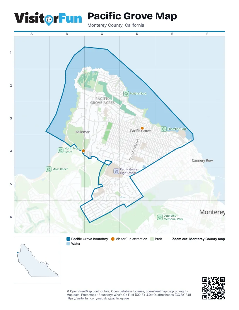
Street index of Pacific Grove
Each street on the sheet and the grid squares it crosses.
- Ocean View BoulevardC1, B2, C2, D2, D3, E3, E4
- Jewell AvenueB2, C2, C3, D3
- Lighthouse AvenueB2, C2, C3, D3, D4, E4
- Sunset DriveB2, B3, B4, C4, D5
- 17 Mile DriveC2, C3, C4
- Acropolis StreetC2
- Asilomar AvenueC2, B3, C3, B4, C4
- Balboa AvenueC2, D2, D3
- Beacon AvenueC2
- Companion WayC2
- Coral StreetC2
- Crest AvenueC2, D2
- Crocker AvenueC2, C3, C4
- Del Monte BoulevardC2, D2, C3, D3
- Egan AvenueC2, C3, D3
- Esplanade StreetC2, D2
- Grove Acre AvenueC2, C3, C4
- Monarch LaneC2
- Pine Garden LaneC2
- Quarterdeck WayC2, D2
- Railroad WayC2
- Ripple AvenueC2, D2
- Sea Palm AvenueC2, D2, D3
- Shell AvenueC2, D2
- Spray StreetC2
- Surf AvenueC2
- Beach StreetD2
- Siren StreetD2
- Arena AvenueB3, C3
- Calle de Los AmigosB3
- La Calle CorteB3
- Pico AvenueB3, C3
- Alder StreetC3, C4
- Avalon PlaceC3
- Bayview AvenueC3, D3
- Bentley StreetC3
- Cedar StreetC3, D3, C4
- Chestnut StreetC3, C4
- Dennett StreetC3, C4
- Evergreen RoadC3, C4
- Forest Park CourtC3
- Heacock AvenueC3
- Laurel AvenueC3, D3, D4, E4
- Locust StreetC3, D3, C4
- Melrose StreetC3, C4
- Melton PlaceC3
- Oak PlaceC3
- Pacific Grove LaneC3, C4
- Pico PlaceC3
- Pine AvenueC3, D3, D4, E4
- Ridge RoadC3
- Short StreetC3, D3
- Spruce AvenueC3, C4, D4, E4
- Walcott WayC3
- Walnut StreetC3, C4
- Willow StreetC3, D3, C4
- 12th StreetD3, D4
- 13th StreetD3, D4
- 14th StreetD3, D4, D5
- 15th StreetD3, D4
- 16th StreetD3, D4
- 17th StreetD3, D4
- 18th StreetD3, D4
- 19th StreetD3, C4, D4
- 20th StreetD3
- Briggs AvenueD3
- Caledonia StreetD3
- Carmel AvenueD3, E3, D4
- Central AvenueD3, E3, E4
- Clyte StreetD3
- Congress AvenueD3, C4, D4, C5
- Cypress AvenueD3, D4
- Doc Ricketts RowD3, E4
- Forest AvenueD3, D4, D5, C6, D6
- Fountain AvenueD3, D4
- Garden LaneD3, E3
- Gardner's AlleyD3, D4
- Grand AvenueD3, D4
- Granite StreetD3, C4, D4
- Grove StreetD3
- Lobos AvenueD3, C4, D4
- Marine StreetD3
- Mermaid AvenueD3
- Moss StreetD3
- Naiad StreetD3
- Pacific AvenueD3
- Park PlaceD3
- Park StreetD3, D4
- Union StreetD3
- Wood StreetD3, C4, D4
- 10th StreetE3, D4, E4
- 11th StreetE3, D4
- 1st StreetE3, E4
- 2nd StreetE3, D4, E4
- 3rd StreetE3, E4
- 4th StreetE3, E4
- 5th StreetE3, E4
- 6th StreetE3, E4
- 7th StreetE3, E4
- 8th StreetE3, D4, E4
- 9th StreetE3, D4, E4
- Monterey AvenueE3, D4, E4
- Pearl StreetE3
- Beauford PlaceC4
- Day CircleC4
- Gibson AvenueC4, D4, E4
- Hillcrest AvenueC4, D4
- Junipero AvenueC4, D4, E4
- Laurie CircleC4
- Maple StreetC4
- Marino Pines RoadC4, D4
- Pedersen CourtC4
- Rosemont AvenueC4, D4
- Ruth CourtC4
- Sinex AvenueC4, D4
- Todd LaneC4, D4
- Weldon Grove PlaceC4
- Workman PlaceC4
- Beaumont DriveD4, D5
- Eardley AvenueD4, E4
- Filmore StreetD4
- Gate StreetD4
- Hillcrest CourtD4
- Olmstead AvenueD4, D5
- Petra LaneD4
- Reservoir Line StreetD4, E4
- Spazier AvenueD4
- Terry StreetD4
- Acacia AvenueE4
- Archer StreetE4
- Dewey StreetE4
- Evans AvenueE4
- Laine StreetE4
- Lily StreetE4
- Line StreetE4
- Oak StreetE4
- Pine StreetE4
- Sloat AvenueE4
- Spencer StreetE4
- Acorn CourtC5
- Arkwright CourtC5
- Benito CourtC5, C6
- Brentwood CourtC5
- Buena Vista AvenueC5, C6
- CC EstateC5
- Clark LaneC5
- Country Club GateC5
- David AvenueC5, D5
- Forest Hill BoulevardC5, D5
- Forest Lodge RoadC5, D5
- Glen Lake DriveC5, D5
- Heather LaneC5
- Heather PlaceC5
- Hillside AvenueC5, C6
- Kenet PlaceC5
- Lincoln AvenueC5, B6, C6
- Moreland AvenueC5
- Patterson LaneC5, C6
- Piedmont AvenueC5, D5, C6
- Presidio BoulevardC5, C6
- Redwood LaneC5
- Sage CourtC5
- Sage PlaceC5
- Syida DriveC5, C6
- Timber TrailC5
- B StreetD5
- Bishop AvenueD5, D6
- Bishop PlaceD5
- Bishop WayD5
- Country Club Gate CenterD5
- Divisadero StreetD5
- Irving AvenueD5
- McFarland AvenueD5
- Morse DriveD5, C6
- Pine CircleD5
- Platt CourtD5
- Prescott AvenueD5
- Prescott LaneD5
- Ransford AvenueD5, C6, D6
- Ransford CircleD5, D6
- Seaview AvenueD5
- Stuart AvenueD5
- Miles AvenueB6, C6
- Austin AvenueC6
- Benito AvenueC6
- Funston AvenueC6
- Lawton AvenueC6
- Montecito AvenueC6
- Otter LaneC6
- Pacific Grove-Carmel HighwayC6
- Ransford CourtC6
- Shafter AvenueC6
- Adobe LaneD6
- Halleck RoadD6
Things to do on the Pacific Grove map
Places on the map
- Ace Hardware
- American Tin Cannery
- Andril Fireplace Cottages
- Andronico's
- Anytime Fitness
- Archie's American Diner
- Arnett Park
- Asilomar Conference Grounds
- Asilomar Dunes Natural Preserve
- Asilomar State Beach
- Beachcomber Inn
- Berwick Park
- Best Western the Inn & Suites Pacific Grove
- Bide-A-Wee Inn & Cottages
- Borg's Motels
- Breaker Stadium
- Butterfly Grove Inn
- Caledonia Park
- California Seltzer Co.
- Carl's Jr.
- Central Coast Silkscreen & Embroidery
- Central Presbyterian Church
- Centrella Inn
- Chapel
- Country Club Gate Shopping Center
- El Carmelo Cemetery
- Forest Grove Elementary School
- George Washington Park
- Hayward Lumber
- Hayward Park
- Lover's Point Park
- Lovers Point - Julia Platt State Marine Reserve
- Monterey Bay Charter School
- Pacific Grove Golf Links
- Pacific Grove High School
- Pacific Grove Marine Gardens State Marine Conservation Area
- Pacific Grove Middle School
- Perkins Park
- Shoreline Park
- The UPS Store
Next to Pacific Grove
- Cannery Row
- Monterey map
- New Monterey
- Ocean View Plaza
- Spaghetti Hill
© OpenStreetMap contributors, Open Database License, openstreetmap.org/copyright · Map data: Protomaps · Boundary: Who's On First (CC-BY 4.0); Quattroshapes (CC BY 2.0)















