

California map
Riverside-San Bernardino-Ontario Metro Area map
The sheet's index lists 19 highways; I-15, I-10 and I-40 cross the most grid squares. Things to do inside the boundary: Agua Caliente Casino Rancho Mirage, Agua Caliente Cultural Museum and Alpine Slide at Magic Mountain. Also on it: Barstow, Big Bear City and Blythe.
Open the map (PDF, US Letter)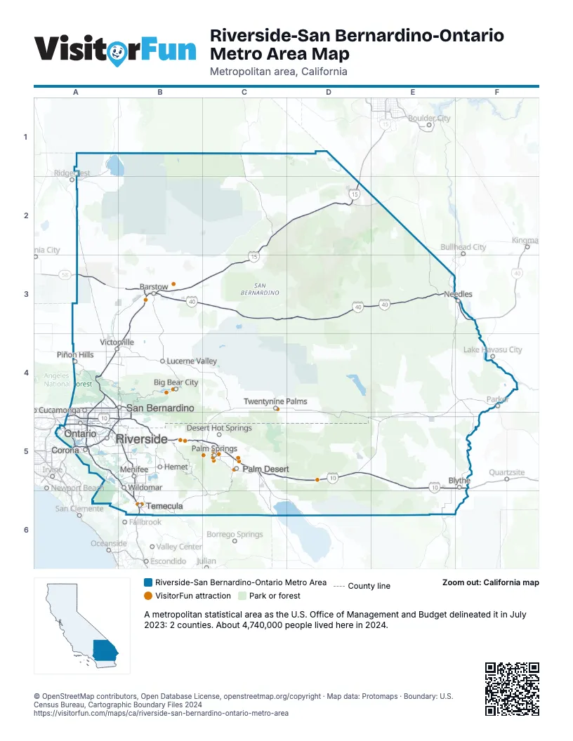
Highway index of Riverside-San Bernardino-Ontario Metro Area
Each highway on the sheet and the grid squares it crosses.
- I-10A5, B5, C5, D5, E5, F5
- I-15A4, A5, B3, B4, B5, B6, C2, C3, D2
- I-40B3, C3, D3, E3, F3
- I-215A4, A5, B5, B6
- US 66A4, B3, E3, F3
- US 91A4
- US 95E3, F3, F5
- US 99A5, B5, C5
- US 395A4
- CA 18A4
- CA 58A3, B3
- CA 60A5, B5
- CA 71A5
- CA 86C5
- CA 91A5
- CA 111B5
- CA 210A4, B4, B5
- CA 259A4, B4
- CA 330B4
Things to do on the Riverside-San Bernardino-Ontario Metro Area map
- Agua Caliente Casino Rancho Mirage
- Agua Caliente Cultural Museum
- Alpine Slide at Magic Mountain
- Big Bear Snow Play
- Cabazon Dinosaurs
- Cabazon Outlets
- Calico Ghost Town
- Classic Club
- Covered Wagon Tours
- Desert Hills Premium Outlets
- Escape Room Palm Springs
- Fantasy Springs Resort Casino
- Five Star Adventures Tours
- General Patton Memorial Museum
- Indian Canyons
- Joshua Tree National Park
- Mojave National Preserve
- Morongo Casino Resort & Spa
- Ontario Mills
- Palm Springs Aerial Tramway
- Palm Springs Air Museum
- Palm Springs Art Museum
- Pechanga Resort Casino
- Promenade Temecula
- Red Jeep Tours by Desert Adventures
- Spotlight 29 Casino
- Tahquitz Canyon
- Temecula Valley
- Temecula Valley Wine Country
- The Outlets at Barstow
- Victoria Gardens
- Yaamava' Resort & Casino
Places on the map
- Barstow
- Big Bear City
- Blythe
- Corona
- Desert Hot Springs
- Hemet
- Lucerne Valley
- Menifee
- Needles
- Ontario
- Palm Desert
- Palm Springs
- Piñon Hills
- Rancho Cucamonga
- Riverside
- San Bernardino
- Temecula
- Twentynine Palms
- Victorville
- Wildomar
© OpenStreetMap contributors, Open Database License, openstreetmap.org/copyright · Map data: Protomaps · Boundary: U.S. Census Bureau, Cartographic Boundary Files 2024